
What is Reddit's opinion of
Skew-t?
From 3.5 billion Reddit comments
Popularity Score: 1
This app was mentioned in 9 comments, with an average of 2.33 upvotes
Best Comments
https://play.google.com/store/apps/details?id=com.ajw.skewt&hl=en_US is my preferred predictor for wind shear, turbulence, excessive convection, mountain wave, etc. etc. .
I've found it very good for training my eye/brain to see and understand what is happening in the sky.
It takes about six months of daily use to get proficient at using it, so it is definitely not for everybody. Good for weather geeks though!
There are better subscription based forecasting tools out there, but I like the 'read it at a glance' quality of skew-T. Lately I've started to use windy to get a 'big picture' understanding of how the weather is developing.
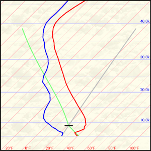
There are several 'rules of thumb' that predict turbulence. The location is largely predicted by the atmospheric temperature, wind , sun angle, terrain and the interaction of these factors. The skew-T diagram and the graph of wind direction and speed vs. altitude have the data that you need. Read it before your flight and you will have a better idea how to deal with the turbulence that you encounter.
For example, one useful rule of thumb predicts wind shear in the pattern. If the wind graph shows a rapid increase in wind speed from ground to pattern altitude, you will have dangerous wind shear. Likewise wind shear happens around the altitude where wind direction changes, so a wind direction change close to ground predicts wind shear in the pattern.
After you learn what the basic lines on the skew-T mean, one way to master it is to look at the diagram and the sky before and after every flight, and compare the diagram to what you encountered during the flight. Takes some work, but it is worth it. Here is the android app that I use https://play.google.com/store/apps/details?id=com.ajw.skewt&hl=en
Op's turbulence was probably caused by rising air heated by the buildings that he flew over, which is the interaction of sunlight with 'terrain'.
If you want to know whether you should go soaring in the next 12 hours, when to launch, how late in the day you will find lift and how high the lift will take you, and at what hour of the day to expect lift to turn into thunderstorms... get this skew-t/winds_aloft tool https://play.google.com/store/apps/details?id=com.ajw.skewt (or something similar) and practice using it. Look at how the skew-T changes as the day progresses.
To practice, 1)look at the skew-T for the present time, then look at the sky/weather and see how the skew-T explains it. 2)After a few weeks of practice, look at the sky/clouds and try to imagine what the skew-T will look like. Then look at the skew-T and see what you got right/wrong.
Skew-t looks complicated, but the effort to master it is well worth it.
Obviously you have to consult some basic texts to learn about how/when lift develops and clouds form to make sense of skew-t, but make mastering skew-t your goal and you will be rewarded.
https://play.google.com/store/apps/details?id=com.ajw.skewt&hl=en is a nice implementation of Skew-T done by a glider pilot in Chicago. It's all I need. I also like the histograms on weather.gov (in the USA) for a general overview of the next few days.
I had a subscription to XC Skies when I first started flying. The graphics were seductive. The data resolution is high, but the accuracy was low in the mountains. It might work better in the flatlands.
skysight seems to be the up and coming product. Windytv.com is very nice presentation of the raw data.
It interesting to learn how to interpret the raw data. You start to notice little things after a while. Like last year I learned how to predict the severity of rotor and wind shear close to the ground for aerotow. I've used this as a data input for making a go/no-go decision in mountain wave season.
I've been using this android app https://play.google.com/store/apps/details?id=com.ajw.skewt Down the right side, it shows wind speed and direction at altitude
I've not looked at other available apps/sites.
Learning to read the skewT takes lots of practice and a little study.
I look at the skewT and try to figure out what is happening in the sky, and then I look at the sky.
Another exercise is to look at the sky, think about what is going on and imagine what the skew-t looks like, then look at the skew-t.
>Then for some bizarre reason, the layer started forming into overcast.
Do you know about skew-t diagrams? It takes some effort to learn how to use them but the effort pays off in terms of understanding the formation of condensed water vapor.
A nice free app: https://play.google.com/store/apps/details?id=com.ajw.skewt
Wave is complicated. Here are a couple of things that might help.
Understanding the generic structure of wave and visualizing where you are in the wave structure during your actual flight is key to minimizing your time spent in downdrafts and turbulence. There are two basic structures for wave. Lee Wave is the most commonly described. Stationary Wave stacks up differently. Both types form in the mountains. If wind speed increases with altitude you get Lee Wave. If wind speed is more constant with altitude, then you're more likely to get Stationary Wave.
Skip to chapter 7 in this document to get a practical visualization (without the math)
https://www.schwerewelle.de/literatur/dieter-etling-atmospheric-gravitywaves-and-soaring-flight
I use the following Android App to look at the skew-t at points along my intended route https://play.google.com/store/apps/details?id=com.ajw.skewt&hl=en_US
The rest of this comment outlines what I do in a glider. Maybe some of it is applicable to powered flight. Both aircraft categories can exploit updrafts and minimize time in downdrafts and turbulence. Rotor occurs below the wave because of the wind gradient between surface wind and wind aloft. The stronger the gradient, the stronger the rotor (aka turbulence).
I head into the wind and stay in the sweet spot of the wave (the updraft) to climb to my target altitude ASAP. Since my airspeed is greater than the wind speed, I need to orbit around a point on the ground, leveling the wings when flying upwind and banking steeply when not flying upwind. Keep an eye on the VSI (vario) to stay in the updraft and avoid the downdraft. Once I reach my target altitude (or as close to the target as the updraft allows), I head downwind on my intended course. My target altitude anticipates that I will hit the downdraft part of the wave and lose considerable altitude, but since I'm flying downwind I will spend minimum time in the sink.
If I'm flying in Lee Wave I anticipate that I will find the secondary updraft that will let me recover the lost altitude. In Stationary Wave, I may top out in the Primary Updraft before I reach my target altitude, so I will need to linger in the Secondary Updraft to achieve my target altitude. Rule of thumb is 'go high and stay high'.
Should the wind direction change above the mountain wave layer, wind shear will form turbulence. There is usually smooth air above and below the windshear layer. (The Skew-T app graphs wind direction and speed vs. altitude, and you can use it to predict the wind_shear_turbulence altitude.)
If I want to fly from Point A to Point B, I will typically take a zig-zag course. The Zig heads directly downwind to minimize my time in the sink. The Zag crabs into the wind to maintain a course that keeps me in the updraft part of the wave. The art of flying XC in wave lies in visualizing where the up and down drafts are found, and then finding a zig-zag course that gets you to your destination. Keep in mind that on the return 'upwind' leg of the journey it will be harder to maintain altitude (because the aircraft will spend more time in the downdraft part of the wave).
I do my best to NOT fly a heading that keeps me in the downdraft longer than necessary. The VSI (vario), wind direction, and terrain help me find the updraft where I'll orbit to climb to my target altitude. My moving map software guesses/calculates the actual wind direction and speed at my current altitude. That real time information is invaluable because the wind aloft forecasts factor out the localized variations that happen in the mountains.
>at about 1,000 ft agl hit a strong thermal and got 1,500+ ft on the VSI.
Would be useful to sort out the sources of rising and sink air masses and to better understand how wind interacts with terrain. A "thermal" refers to a rising column of air. It is unlikely that your lift came from a thermal. You stayed in the lift for long enough to notice it and see it register on your VSI. On a straight course you would have felt a 'bump' from a thermal and you would have flown through it in a few seconds. 1500 fpm - engine induced climb rate = 1000 fpm, (say 10 knots) is unusually strong lift to find in a thermal at 1000 agl. This would be likely only in the central core of a thermal (but you'd have to fly at 40 knots at 45d bank to stay in the core). So you were probably experiencing slope, ridge or rotor lift, all flavors of wind interacting with terrain.
>but couldn't go to far left or right due to 2,000-3,000 ft hills
The fact that you were flying between two ridges (aka lines of hills), and near or below the top of the ridges, suggests slope, ridge, or rotor lift. The wind direction was probably perpendicular to the ridge lines. Ridge lift would develop on the windward side of hills/ridges, but you have to be rather close to the ridge and pretty low to the terrain. Ridge sink develops on the leeward side of a ridge, but again you need to be pretty close to the ridge line to experience it. I doubt that you were in slope lift because you have to be pretty close to terrain to get into it (many glider pilots get nervous in slope lift).
Since you were in a power plane I assume that you were flying down the center of the valley between the two ridges. And since you stayed in the lift (and later sink) for a while, it sounds like you were experiencing Rotor. Visualize rotor as a rotating barrel with the axis of rotation parallel to the ground. The air is rising on one side and falling on the other. In reality, rotor is a lot more chaotic because of the undulations in the terrain (even with stable laminar wind flow), but in general you will find lines of lift or sink roughly parallel to the ridge lines. In all likelihood, you were flying in a line of rotor lift, and then you were flying a line of rotor sink. If you increased your crab angle and moved perpendicular to the wind (upwind to avoid getting blown into terrain), you probably would have moved out of the rotor sink line.
This time of year, it is common to have wind increase with altitude. You really need to check the wind gradient before you take off. 10 knot wind on the ground is not enough information. The location and intensity of rotor is for the most part predictable from terrain, wind gradient and direction. A report of wind shear is a crude report of wind gradient. I generally look at wind speed plotted graphically against altitude and skew-T (free android app https://play.google.com/store/apps/details?id=com.ajw.skewt )
If you'd foreseen the rotor and deliberately stayed in the area of lift and climbed above the ridge lines, you might have entered mountain wave this time of year (due to winds increasing with altitude and layer of stable air). If you want to fly in Mountain Wave, you need to understand that it can generate strong lift and strong sink. The winds are commonly above 50 knots and if you let yourself drift downwind, you'll move from lift to sink. In a glider, we commonly fly straight into the wind and stay stationary over the ground and climb to just below flight levels. The strong wind makes it hard to make progress over the ground in a small plane.
While mountain wave is generally extremely smooth air, you will also find patches of rotor and extreme turbulence mixed in with the smooth air, and so you generally want to keep the ASI in the green range. This is another reason why it is harder to fly XC in an arbitrary direction in wave.
If you want to fly a power plane in rotor and wave, you'd best study up and take some additional training. VFR-->IMC is another hazard.
Tldr: Know the wind gradient before you take off. Know how to deal with Rotor, or stay on the ground when it is likely. Rotor is a crap shoot, treat it with extreme caution.
Is it this one? https://play.google.com/store/apps/details?id=com.ajw.skewt