
What are
/r/NCTrails'
favorite Products & Services?
From 3.5 billion Reddit comments
The most popular Products mentioned in /r/NCTrails:


The most popular Services mentioned in /r/NCTrails:
AllTrails
Geocaching
Airbnb
WebMD
The most popular VPNs mentioned in /r/NCTrails:
The most popular reviews in /r/NCTrails:
A lot of the comments have already touched on permits (won't need one), campsites (there are plenty, and they are marked on maps), maps (download Avenza and use that to plan campsites + water refills), so I'll touch on a different point.
For a new backpacker the Gorge can be pretty tough. They say in the Gorge you shouldn't expect to go more than 1MPH and that's absolutely true - elevation changes can get brutal.
That being said, I think that the Gorge IS a great choice for new backpackers as there are trails that are not too hard but have tremendous views. For someone new to walking up and down steep elevation changes with a 20 pound pack, I would say don't do the Gorge Loop; my recommendation would be to start at the Spence Ridge trailhead, hike down to Shortoff Mountain to stay the night, and hike back the next day (assuming you can start by around 10/11AM). It's difficult enough to make you feel like you're getting a workout in, but moderate enough that a new backpacker should be able to handle it given they're not completely out of shape; it will also give you some of the highlights of the Gorge (Table Rock, Chimneys, Shortoff), with tremendous views both to the West and the East!
https://www.alltrails.com/explore/map/sun-18-oct-2020-23-04-a081c17?u=i
You can also make this easier by cutting out the entire first section of elevation gain (which is fairly tough) by parking at the Table Rock parking lot and starting from there. The road up to it is closed during winter though, not sure if it'll reopen by March.
Black Balsam Knob is what you're looking for. It's easy to get to. It's part of the Shining Rock Wilderness. The whole area is spectacular.
It's spectacular at sunrise or sunset.
Bears exist, but they'll leave you alone unless you threaten them, surprise them, or leave your food out for them to find. They typically steer well clear of hikers if they hear you coming.
Cold Mountain is also a nice spot, but not nearly worth the effort if you had to pick one or the other.
I did an overnight there a few months ago. Left the car at the Black Mountain Campground. We paid $5 and they let us use the showers the next morning too. I've added a link to my hike, hopefully it works. I'm not sure how accurate the mileage is. It was messing up a little but I have camping spots and water locations saved. https://www.alltrails.com/explore/recording/mount-mitchell--29?p=-1
I’ve walked the ridgeline trail. It’s 13.7miles, half a marathon, up hill from Kings Mountain North to the peak of Pinnacle in Crowders mountain state park and down to the Visitors center. It would be a great trail to walk in the fall/winter once the leaves change and drop off the trees. Otherwise you can’t see much past the trees. Last year when I went it was very well maintained.
Here’s a link to my all rails record.
Awesome, thanks for the link! This little pocket map you can buy on Amazon was super helpful to me when I did the ALT a couple years ago, I would've never found the spring near the Sam Knob trailhead parking area without it.
There are absolutely spots near Celo. More specifically, at the intersection of the Crest Trail and Woody Ridge Trail. Probably room enough for 20 tents in the clearing.
There is a spot that is more covered, north of this intersection as well. Before the trail starts to descend, you'll do a little zig zag, right and then left. Where you make this left you can go right, into the trees and find one or two spots.
Grassy Ridge bald is probably one of my top picks. It's probably one of the only balds over 6000 feet. From Carver's Gap (lots of free parking but it can fill up) at Roan mountain, hike northbound on the AT then at Grassy ridge junction take a right and hike up the bald. In total just 2.3 miles from the road, but it's a somewhat strenuous hike up. https://www.alltrails.com/trail/us/north-carolina/grassy-ridge-bald-via-appalachian-trail
If you don't want to hike that far, the first bald you come to is Round Bald, right after you hike up from the parking lot about half a mile. However, lots of people stop there rather than go all the way to grassy bald so on a weekend it'll be packed. I saw people setting up camp in July about 3pm so they could get a good spot there.
Another option close by is to go from US 19E southbound on the AT to big hump bald. That's a good 5.3 mile hike up.
If you don't mind going a little north of the border, Grayson Highlands in Virginia is a good option. You can't disperse camp without the state park land, but it's only about 1.7 miles to the Mt Rogers National Recreation area and there's a lot of places to camp along the Appalachian trail headed southbound towards Mt Rogers and Thomas Knob shelter. Another option close to there is Whitetop mountain which you can actually drive to the top of. Plenty of dispersed sites at the top and along the forest service road to the top.
Colbert Ridge To Mt. Mitchell To Maple Camp Ridge Loop (https://www.alltrails.com/trail/us/north-carolina/colbert-ridge-to-mount-mitchell-to-maple-camp-ridge-loop?p=-1)
I've not hiked the Mt. Mitchell trail, however I have hiked the loop named above. It was an extremely challenging hike, but also very rewarding. I loved the view of Mt. Mitchell as we hiked down Colbert Ridge. It was beautiful the whole loop. I went with a couple friends to hike and go check out the breweries afterwards. We decided it would be cool to camp up top one night and so we did. However, I wish we would have gotten there earlier and could have had the option to finish in a day if we wanted. We started hiking at about noon, but if we had started at eight we would have been fine to finish before dusk. I packed way more unnecessarily since we were camping up top and that led to me slowing down a lot. Pack light. If you want to do this as a day hike.
As for breweries, I feel like Sierra Nevada is a must see during the day when the sun is out. I loved Sierra Nevada - some consider it the Taj Mahal of breweries. Wicked Weed is super cool as well. I haven't visited New Belgium, but next time I'm near the area I'll be going there.
EDIT: I went during the spring. I'm not sure how the weather conditions are right now.
If you have two cars at your disposal, I'd recommend considering the App Trail section in the Roan Highlands between 19E and Carver's Gap. You will need to start early, though, both parking lots tend to fill up pretty quickly after daybreak.
https://www.alltrails.com/trail/us/north-carolina/appalachian-trail-carvers-gap-to-us-19e
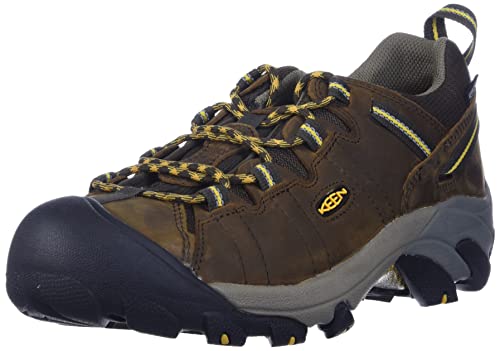
I was a boot guy for many years until switching to hiking shoes. I've been really, really happy with a pair of Keen waterproof Targhee 2's that I've been wearing for the past 5 years. These shoes have been the absolute best hikers I've ever had. I've put thousands of miles on these all over from NC/Pisgah/Great Smokies/Uwharrie/Eno River to the Sonoran desert in Arizona, Rockies in Colorado, Cascades in Oregon and many other places and these shoes have always been great.
Difficult trails and rivers you say? I'd suggest hiking up Woody Ridge Trail to Celo knob and down Bowlens creek to it's trailhead on the other side of the ridge. It'll be a tough hike, you'll get insanely amazing views on top of the black mountain crest (over 6000 feet of elevation on Mt Mitchell's ridge), and beautiful camping next to a wild stream.
The BMCT is no joke. The hike up to Celo Knob is an absolute calf burner. I was hiking in a t-shirt on a 35-degree day and was still warm from how intense the hike was. Apparently there's a different trail up that may as well be a scramble, excited to try it.
You can make a nice 18-ish mile loop out of three trails on and around the Chattooga river beginning at Burrells Ford. The Foothills trail, Fork Mountain trail and Chattooga River trail make up the loop. I'd begin on the Foothills, then take the fork Mountain to the Chattooga.
I think I'm gonna take my friend who's not a hiker to the "four waterfalls trail" at Dupont on Friday. I am assuming this is the directions and hike you are talking about. https://www.alltrails.com/trail/us/north-carolina/four-waterfalls-trail
As for me solo hiking/running on Saturday I'm still on the fence between: 1) Looking glass (looks like the coolest but not sure it's accessible), 6.5 miles
2) John Rock (a bit shorter than Looking glass but perhaps not as scenic) 5 miles
3) Mt. Pisgah looks like a short hike but not sure the view looks as cool as the looking glass rock.
The Roan Mountain/Carvers Gap to US 19 section of the Appalachian Trail
Incredible views on the first day of this hike and lush wooded trails on the second day.
Carry enough water on the first day to get to the Red Barn area.
I didn't think this was close enough, but it's 2 hours 45 minutes from Charlotte.
You’re looking ay the wrong pinnacle. It’s nowhere near a visitors center. It’s a very lesser known park.
Check out this trail on AllTrails. https://www.alltrails.com/trail/us/north-carolina/the-pinnacle-trail
It’s a little more than three hours away, but check out the Woody Ridge Trail (177) on the east side of Celo Knob in the Black Mountains! About 3000’ of vertical over 2.4 miles one way. It takes you up to the Black Mountain Crest Trail, which you can (and should) keep hiking on to reach Mt Mitchell! If you like scrambling, check out the Left Wishbone Rock Scramble that is accessible from this trail. Note that this scramble is pretty remote by southeastern standards.
Woody Ridge Trail Hikingproject
Left Wishbone Scramble Mtnproject
There is no campground at Deep Gap. I hope you're not expecting any services whatsoever. There is also no water unless you go a little bit down Colbert Ridge Trail. It's a rocky, steep trail, but you shouldn't have to go more than a mile.
The trail out to Deep Gap is seriously one of the most unique in WNC. Expect extremely rocky terrain at times, and a few sections where hand lines are in place. Have fun, and double however long you're thinking it will take to get out to Deep Gap. Also, hike north of there to Celo and all those peaks if you can, it's amazing and not to be missed.
I've only camped up there once. I typically run it. There are only two places possible to camp, otherwise the terrain is prohibitive. Deep Gap and next to Celo Knob at the north end of the trail, before it forks off to Bowlens and Woody Ridge. The camping is great...spectacular views on a narrow ridge. No water tho.
I did 19E to Hump mountain - up hill pretty much the whole way but I didn’t think it was so bad - here’s the details : https://www.alltrails.com/trail/us/tennessee/appalachian-trail-19e-to-hump-mountain?p=-1
That would be the entire trail. The sections I'm referring to is approximately this...
https://www.alltrails.com/trail/us/south-carolina/foothills-trail-a4-to-a8
Our ACD mix had no problems with anything in The Gorge. just checked her feet for pebbles after any rocky sections
did [pinch-in- > linville river -> conely -> rockjock](https://www.alltrails.com/explore/trail/us/north-carolina/pinchin-to-linville-river-to-conley-to-rock-jock)
As a couple other people have said, do a portion or all of the 5 peaks trail at Hanging Rock. https://www.alltrails.com/trail/us/north-carolina/five-peaks-hike The 5 peaks are Moore's Knob, House Rock, Cook's Wall, Wolf Rock, and Hanging Rock. If you start with Moore's Knob, then go to House Rock/Cook's Wall (Counterclockwise around the loop) you should be in the 5-6 mile range, with the option to extend by going to Wolf Rock and then Hanging Rock to finish out the 9 mile total loop.
I wouldn't really describe any of the trails as overly strenuous. Moore's Knob is IMO the most difficult with a large number of uneven stone steps.
Sleeping Bear and Hawksbill connect to it. Here's the AllTrails page for it: (https://www.alltrails.com/trail/us/north-carolina/devils-hole)[https://www.alltrails.com/trail/us/north-carolina/devils-hole]
"10 essentials" cache seems to be at Kitsuma/Youngs Ridge and people have told me it makes you crawl all over Young's Ridge but no further... I did Kitsuma a couple years ago with my dog (letterboxing, and one Geocaching DNF) and hadn't seen this tag.
The tag in this photo is at Catawba Falls, way farther down towards Pisgah Forest.
I went home after finding this little guy to see if any caches were near him. These were the closest ones:
Know I'm a little late to the party, but it might be a virtual geocache. They use a ghost symbol when there is no cache and the number above it might be a clue to a puzzle to get to the next set of coordinates.
Edit: Possibly this one-- seems to be in the area? http://www.geocaching.com/geocache/GC1915Z_happy-hiker-1-the-ten-essentials#
The hardest part will probably be the bushwhacks up Celo, Horse Rock, Gibbs, Deer and maybe the bushwhack from Clingmans to the MST near Patton Knob. We did it in 2 days but were not trying to hit all the peaks and used some other trails we wanted to check out. 2 days because we ran out of water but had planned on 3, that made the last day a 20 miler, that was a long day.
There's probably a 120V duplex outlet in the box with the RV outlet, but you could get something like this if it's worth $30 to not take the risk: https://www.amazon.com/Rophor-Adapter-14-50P-Household-Protection/dp/B08NXHHCKG
If it won't get to you in time, then have it shipped General Delivery to the post office in Brevard and pick it up there.
I've done the Mt. Mitchell trail. Is that your preferred summit method to Deep Gap trail heading towards Mt. Craig and eventually BMC? Also, are you saying that going up Bowlens to Celo is the easiest of 5 ways? I've heard that's a very strenuous uphill hike to Celo from Bowlens. Thanks for your response!
I'm looking into the BMC trail. Celo to Mt. Mitchell camping at Deep Gap. Do you have a suggestion regarding starting at Bowlens Creek trailhead and going south to Mitchell, or start at Mitchell and head north ending at Bowlens Creek trailhead?
I really don't want to dissuade you if you're down for the challenge, but the sun isn't going to do much. Microspikes would be essential. I posted this in a recent thread, but I was up there on 1/1 this year in the 40s/50s, after a week of moderate weather, and the top mile of the mt Mitchell trail was iced over, with several unavoidable ice stretches. I went for the slide and pray method lol. If you are prepared for potentially harsh winter conditions on a trail with mild to moderate exposure, I'd say go for it. Between Celo and Deep Gap will have some intense sections that actually would be fun with microspikes and some general scrambling skill. But again, this will be more of a challenge than an enjoyable romp overall, so take with that what you will. If you do go for it, please post a report!
Same, re: quest for crest. There's also a variation that makes it even steeper if you're interested in that. The Left Wishbone of Celo...typically an ice climb in winter, but can be done on foot if you don't mind bushwhacking around ice. Essentially before I out get to the steep switchbacking part, you take a side trail east to a drainage that goes straight up to the top of Celo, no switchbacking. If you really hate yourself, you should check it out!
Winter backpacking is fun in it's own way but not for the faint of heart and maybe not beginner friendly... I'd consider waiting until April or May to get started so you aren't battling any potential snow (or even worse, 33F and rainy).
South Mountains state park is close and has a nice water fall loop. I'd also look into Gorges State Park or the south fork of the mills river in Pisgah. Once you get some experience Linville Gorge and the Wilson Creek area are both incredible options but with Linville in particular it is very easy to get lost and hard to bail out if something goes wrong so I would avoid going there by yourself as a beginner.
I found the book below extremely helpful getting started with planning trips, I'd highly recommend it. https://www.amazon.com/dp/0898869668/ref=cm_sw_r_cp_apa_fabt1_56LVFbHQMAZD1
Did it with my dog in 2016, took us 2 nights, we definitely weren't as fast as the other poster! Shining Rock Wilderness, Ivestor Gap (some of the best camp spots on the trail are in this area, which lies a little bit beyond the Shining Rock Wilderness boundary), and Black Balsam Knob have the best views by far. The section between the BRP and Davidson River Campground is very pretty and has some cool geological features, but no long views really other than the ones you get on the Pilot Mtn summit. So, start at Davidson River if you want the best views to be toward the end of the trek. However, if you start at Daniel Boone Camp (which we did), the uphill push to Shining Rock will be the ass burningest portion of the whole trip, and it will be a pretty smooth, gently sloping hike the rest of the way. I highly recommend purchasing this map, which can be found in most NC REI stores for a bit less than Amazon sells it, so be on the lookout if you drop by one the stores before your trip. If for nothing else, the map's got water sources marked very well, they can be a bit spread out during the warm months.
That’s what I had thought! I remember earlier in the pandemic, Pisgah closed down the area around Celo to camping, so I assumed there had to be something out that way. I’m hoping for a few less people in that section. I’ve even seen Maple Camp Bald getting packed in the past year. Thanks!
There's a place south of Celo where people have definitely camped, it's up against an exposed rock wall maybe 25' east of the trail. Somewhere around Cattail Peak, I think?
I have no idea whether or not this would be a legal spot to camp, but it has definitely been used as a campsite.
If you and a group of friends plan on going hiking a good tool for android users would be this app that lets you communicate and keep track of your group with no internet connection required. Spoiler: It works with Bluetooth.
Link : https://play.google.com/store/apps/details?id=com.dstudio.pricesmart.socialparty