
What are
/r/landsurveying's
favorite Products & Services?
From 3.5 billion Reddit comments
The most popular Products mentioned in /r/landsurveying:


The most popular Services mentioned in /r/landsurveying:
The most popular Android Apps mentioned in /r/landsurveying:

Locus Map Free - Outdoor GPS navigation and maps
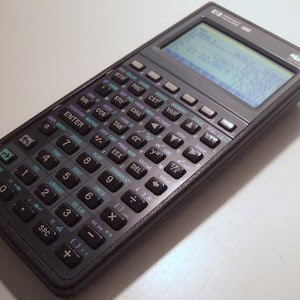
Droid48
The most popular reviews in /r/landsurveying:
Sure can, but its pretty tricky without a serial port on your laptop. You're going to have to use Bluetooth if you don't have one and Sokkia Bluetooth is a serious pain to get working right. Here's the Sokkia CX Manual. Your steps are outlined on page 44 being sure to configure your instrument using page 38.
Depends who set it, but likely it's just a designation in some sort of order for the entity who set it. Could also be stationing for a roadway (ROW Monument, etc)
For example, a LOT of the NGS Benchmark stations in Southern California I've hit are PIDs of "DX......"
You'd need to know what type of monument it was (where it was found usually makes it pretty obvious)
edit: first instinct was spot-on, here you go:
http://www.geocaching.com/mark/details.aspx?PID=DG3184
Original NGS Datasheet: http://www.geocaching.com/mark/datasheet.aspx?PID=DG3184
For Australian Surveyors BENCHMRK is an app useful for finding State Permanent Survey Marks.
I use Droid48 all the time. A HP48 Emulator.
Weather Apps (I use our Government BOM app)
CASA Open Sky (Lets me know if there are restrictions for flying our Drone)
Compass. Just for basic orientation starting an unconnected job.
Tinder. Because, well, Tinder.
Locus Map will do exactly this, as well as creating and exporting tracks in several different formats (kml, gpx, dxf).
Used this app a couple weeks ago - We were on the top of a ridge when the client asked if we could map an old (closed) county road from the top of the ridge all the way down to where the end of this road was still maintained by the county. All I had with me was my LG G4, but I told him I could collect mapping-grade data.
Fired up Locus, began a track and walked down the road for a mile or so. Got back to the office, exported a KML file, checked it out in Google Earth and emailed it to the client. Easy-peasy.
I sweat a lot here in Florida and I prefer Cargo pants for the extra leg room. I bought these CQR pants and I have been happy with them. They take a beating cutting line but still no rips, granted I've only had the a few months. The only thing I don't like about them is I wish they stretched more in the legs when climbing over things and had a little more comfortable waist line. As for chaffing, get some body powder and liberally apply it downstairs. Works for me in these hot months.
Know the Law of Sines and Law of Cosines
I found these two books to be good especially the Reference Manual. Though they definitely aren't the only two good ones out there.
Get a calculator if you don't have one already and learn how to use it so you're comfortable with it. Check the NCEES website to which ones are allowed and make sure you've got one of those. Most guys in survey opt for the HP stuff. When I took the LSIT i used a Texas Instruments because that's what I had and knew how to use but have since switched to HP. They all get it done so it's personal preference.
https://www.amazon.com/Surveying-Construction-Applications-Barry-Kavanagh/dp/0132766981