
What are
/r/nationalparks'
favorite Products & Services?
From 3.5 billion Reddit comments
The most popular Products mentioned in /r/nationalparks:


The most popular Services mentioned in /r/nationalparks:
AllTrails
Airbnb
Roadtrippers
Walmart
The Motley Fool
The Weather Channel
Google Arts & Culture
Microsoft Forms
Cambridge Dictionary
The most popular reviews in /r/nationalparks:
>Why don’t we fund them accordingly?
Humans are pretty well known for choosing short-term benefits with substantial long-term penalties over slower, long term, benefits with minimal penalties. When fracking can get companies around $2 billion/year in excess cash, it's easy for some to ignore the long term disadvantages. Consequences be damned.
Don't overlook the Kolob Canyons section of Zion just off of I15 north of St George. Nice hikes like Middle Fork of Taylor Creek.
Second going to Cedar Breaks to get altitude and away from the heat. Maybe combine day trip to Cedar Breaks with the Kolob Canyon area.
I collect park maps and park patches.
The maps I have on display in my living room in a mail organizer.
I don't quite know what I want to do with the patches. Right now, they're sitting in a faux National Geographic book box.
I came on here to recommend Grand Teton too! My favorite park I've ever visited. My boyfriend is not as big of a hiker as me but we did both Cascade Canyon and Bradley-Taggart Lake trails and he loved them and they weren't too hard for him. Cascade Canyon is an out and back so you can head back whenever too. I should note too that we took the ferry across, so we didn't hike around the lake.
https://www.alltrails.com/trail/us/wyoming/cascade-canyon-trail
You are correct that this is a tension within the National Park Service. It is also a tension in some states between the public and the stewards of the land. Brian Kenner ably addresses this is his new book, "Hard Lessons in a Hard Land," https://amazon.com/HARD-LESSONS-LAND-experience-retaliation/dp/B0948BCGL6/ref=sr_1_1
Amazon has them.
59-piece Deluxe National Parks Postcard Set
My SO has several similar displays all over our place :)
They come in larger poster sizes too
I would love a copy of Zen and the Art of Motorcycle Maintenance, please. I read it as a ranger in the Adirondacks and it's been on my mind ever since - it's high time for a re-read. Should I PM you my address?
I checked it out and found that some people were using a book. She has patterns for all 63 National Parks in this book. I might try to knit a few.
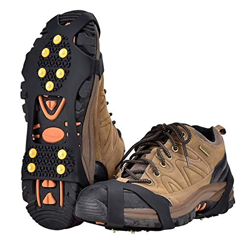
Spikes are definitely a good idea. For 3 days you're better off buying them ahead of time. Useful ones as cheap as $7-15 (depending on size), or better ones for $25ish. Enjoy!
I'm not sure the trail name, but it's the one that connects Yosemite Falls with Half Dome. After climbing up from Yosemite Point towards Half Dome, you'll be walking along a ridge overlooking the valley. When the trail turns north, there's a campsite just over some large boulders.
On the map for this link, there should be a yellow dot that says "Viewpoint for Half Dome and North Dome". That's the spot
Glad to hear that. Hope you enjoy it! Feedback is always welcome.
The trail to Little Devils Tower is shown here. However, if you look at the trail map, it looks like there's an alternate starting point that makes the hike shorter, and I think that's the one I used. My notes say that it's 3.0 miles round trip.
As the map indicates, most of the trail is identified as "Trail 4." The park has a network of trails with multiple destinations possible, so you have to pay close attention to where you're going.
I should add that I had previously hiked to Harney Peak, now called Black Elk Peak. That's a very popular trail, but I found that the trail to Little Devils Tower delivered more bang for the buck - it was shorter, less work, and gave closer views of the rock formations, which is what I wanted.
Hope that helps.
Link to our favorite trails. We're going again in two weeks.
This place is where you park and walk just a little bit to a really great swimming hole.
Paradise Creek Trail also has great swimming opportunities. Have fun and stay safe.
Another SAR guy here.
In the vast majority of places the volunteers are the pros.
And, preemptively, because I've heard this too many times:
professional and volunteer are not mutually exclusive: https://dictionary.cambridge.org/us/dictionary/english/professional definition 1...
We have this job. The fact that we aren't paid, doesn't preclude us from being professionals. We are trained for this job, we have the fitness, determination and skill for this job. These are required to do it correctly.
I don't know /u/Kazan, but I suspect that he's the one inviting people out for beers, and you're the guy that showed up on scene he didn't want to talk to afterwords...
Zion has the Angels Landing hike, although it is really popular and might be really hot in the summer.
Grand Teton also has amazing mountains, but I'm less familiar with the hikes there.
Lost Mine Trail, moderate hike in the Chisos Mountains. Offers stunning views. The border crossing is not 7 days a week. So if that's a must for you check the schedule. I spent 4 days there in May and the border was closed on the early part of the week if I am not mistaken.
We just got back from SEKI. It was our second trip, and it's one (two) of my favorite parks. I recommend driving up to Panorama Point (KC) and having a picnic lunch. Hike to the view point (easy .5 mile trail) then continue on to the Park Ridge Trail south. The Park Ridge Fire Lookout Tower is about 2.5 miles along the trail. Both times we have had the trail to ourselves, and the views are amazing.
You're correct - I forgot the main trail to Observation Pt closed due to rockfall in January. Hopefully open by April but Zion Twitter (@ZionNPS) says "closures are indefinite. We will update as we know more."
Can access Observation Pt via East Mesa trailhead but not as scenic a hike as from Weeping Rock and road to trailhead may be too muddy/snowy yet for easy access in April.
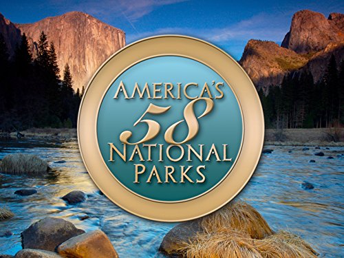
Start here: Your Guide to the National Parks: The Complete Guide to all 59 National Parks (Second edition) https://www.amazon.com/dp/1621280675/ref=cm_sw_r_cp_api_glt_fabc_VJDC375DHT55YJ0BHBBV
Spend time getting to know the parks. Their locations relative to major cities, airports, interstates, family, etc. Get to know their seasons and when best to visit. Get to know how big they are and how long you would need to spend their to explore the whole park. Get to know accommodations, costs, popularity, is it better for kids or teens etc.
From there I would suggest starting small. Hit the closest parks. Get familiar with what family activities interest you: hiking, bird watching, kayaking, biking, ranger programs, guided tours, back country camping, etc. knowing what activities you want to do helps shape your whole trip.
The closer parks will allow you to make sure your child isn’t too young to remember that once in a lifetime family trip to summit Denali or something. As your family grows up, you can all contribute to the planning aspects of a long distance trip so stay small and local for now.
Eventually you will have a baseline knowledge of the parks and road trips to hit a group of parks will become apparent (northern Cali, big 5, pacific NW, I40).
I would also look at the entire NPS program, a lot of monuments and historic battlefields are more common in your neck woods and can provide just as great of an experience.
You need to fill out this application to get a permit, which will include a gate code. It can take up to 48 hrs to get your confirmation. The closing rangers should be doing their rounds about now, and if they’re anything like the park I worked for as a ranger, they will be checking for vehicles before they close down for the night and will get you out. You will probably get some shit, perhaps a ticket as well. Make sure to do your research before heading out next time!
https://roadtrippers.com/ is fantastic. We planned our 4 week RV trip using it, along with some other trips. It has all kinds of resources, places to stay, things to see, and even other people's trips for inspiration.
These page protectors fit them! I put them in binders. https://www.amazon.com/BCW-1-PRO2T-4X10-20-2-Pocket-Envelope-Page/dp/B00TBP8XHW?pd_rd_w=hTtVZ&pf_rd_p=38b2b237-b12b-4ef2-a9e2-848718ec136c&pf_rd_r=K5D1WJ5BWZCC0DXDP6N7&pd_rd_r=ddd6c60b-273d-43bf-afd4-02452e773e40&pd_rd_wg=ElqGd&...
So I got this for the puffy : Puffy Jacket - Amazon
Thinking something like this maybe cheaper for the waterproof jacket? REI Jacket
Michel Digonnet has a great hiking guide for that area, although a bit tilted towards more serious hikes. Lots of info about the dirt roads, natural history, etc. Worth having if you'll be going on more than one trip to the area.
https://www.amazon.com/Hiking-Mojave-Desert-Cultural-Heritage/dp/0965917827
And this is the map you want: https://www.jawbone.org/ohvmap/index.php/maps-guides/ctuc-trail-maps/CTUC%20Map:%20Amboy
/u/211logos is right that you shouldn't limit yourself to national parks. There are lots of great places to visit in that area that aren't national parks, including Dinosaur National Monument, Goblin Valley State Park, Monument Valley, Red Canyon, and BLM sites in the Moab area like Fisher Towers and Corona Arch.
If you're in southeast Utah, don't forget about Colorado - Mesa Verde NP and Colorado National Monument - and Arizona's Monument Valley.
Here are some of my photos from favorite parks and hikes in Utah.
Since you're into photography, I'd recommend this book.
You're skipping a bunch of parks, and I don't know if that's intentional.
Do yourself a favor and get a book on the area like <em>Fodor's Pacific Northwest: with Oregon, Washington & Vancouver</em>. And go the park websites, most at nps.gov. I think Reddit is better for answering questions of a smaller scope than helping you plan a 3-week trip over an area the size of the France.
I got this book and it was been super helpful for planning my trip this upcoming August.
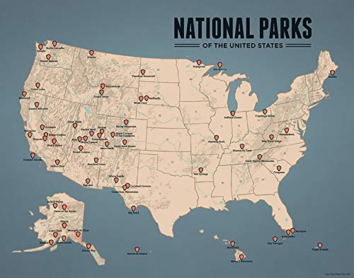
The only guide I'm aware of to all 59 national parks would be the National Geographic Guide. But I have their guide for the Canadian national parks, and I wouldn't regard it as comprehensive.
Frommer's and Fodor's had/have guides that are more comprehensive, but they cover the parks of the West, not all 59 national parks.
If you want more information, you're better off going to the park websites at nps.gov.
Frommer's used to make a large guide to the national parks of the West, which I used a lot, but I don't think they still make it. Looks like you can still get it: http://www.amazon.com/dp/1118118022/ref=sr_ob_2
Fodor's seems to make something comparable: http://www.amazon.com/Fodors-Complete-National-Full-color-Travel/dp/1101879750/ref=sr_1_1
Obviously that doesn't cover the whole country or even all NPS sites in the West. But a book like that is a decent place to start.
Lonely Planet might have something worthwhile, too.