
What are
/r/amateursatellites'
favorite Products & Services?
From 3.5 billion Reddit comments
The most popular Products mentioned in /r/amateursatellites:


The most popular Services mentioned in /r/amateursatellites:
Gqrx
ezgif.com
Discord
SwissTransfer
Homebrew
The most popular reviews in /r/amateursatellites:
sorry for such a long wait, but uploading took a while!
It's a 16bit 6MSPS baseband centered on 1707 (all the meta is missing because I had to shrink the file)
It's from NOAA-18. It has about 15dB SNR at most and is more than enough for a decent decode. I hope that helps!
https://www.swisstransfer.com/d/356acf33-9b9b-48c3-a170-d3aa42464648
I'm not really sure I just know that it worked. Much better for me. You can get 50ft of rg58 on Amazon for $18 here
Try without the Sawbird. My dipole is the same as yours but without the filter. It's about 5 meters above ground in a tree and it works okay. You should ask in this discord server: https://discord.com/invite/msJ5kyJ. Plenty of experienced people in there.
If you installed it with the package manager, there's a chance that it downloaded bad dependencies.
Try downloading it from the gqrx website: http://gqrx.dk/download/gqrx-sdr-for-the-raspberry-pi
there should be a readme file for you to follow
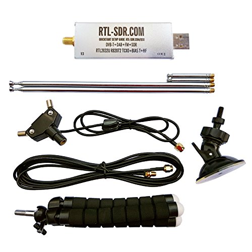
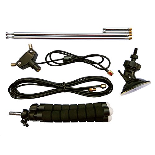
This looks like a good starter kit, it has a variety of different antennas for different frequencies. As far a software for for windows I would recommend SDRSharp https://airspy.com/download/ , for Linux and Mac I would recommend GQRX http://gqrx.dk (can be got from repositories).
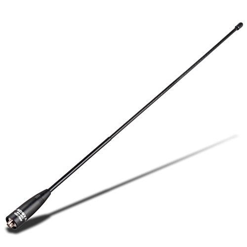
This will work better. It is designed specifically for 1.7GHz.
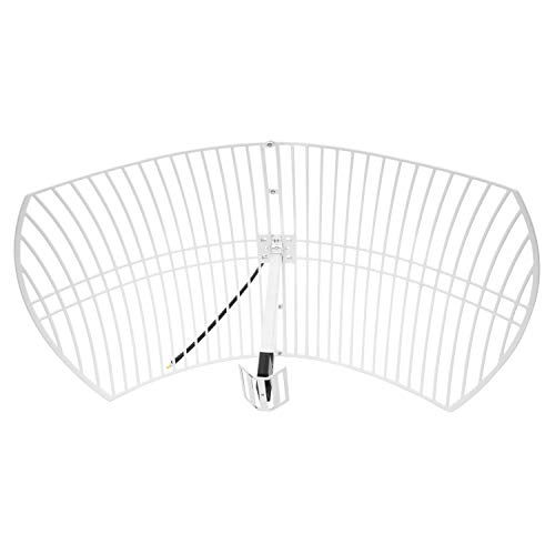
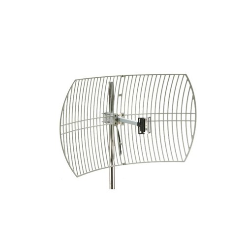
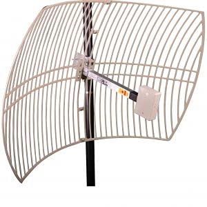
I'm in Minnesota and have received it with the standard wifi dish (https://smile.amazon.com/gp/product/B07DQS39RZ/ref=ppx_yo_dt_b_search_asin_title?ie=UTF8&psc=1), but had issues in bad weather. I since changed that antenna to this one: https://excel-wireless.com/product/1710-2170mhz-23-dbi-grid-parabolic-antenna/ now the signal is rock solid. Edit - it is also at 22 degrees for me as well.
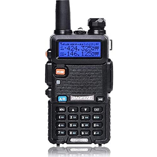
Nice! I'm surprised your setup worked as well as it did, actually, and you've made me want to try my UV-5R next time I have the chance.
If you can afford to buy or build a better antenna, that will help a lot. V dipoles (specify it's for NOAA), quadrifiliar helixes (QFH antennas), and double crossed dipoles are common choices with varying build difficulties. Even a bigger "rubber duck" would work better, if you want something easy. I have this one and I like it, although I've never tried it for NOAA.
Another thing that's effecting you is probably the UV-5R's receive bandwidth. I haven't found any good sources on what its receive bandwidth actually is, but it's probably 12.5 or 25kHz. Unless it's wider than a NOAA signal (34kHz), which I think it won't be, you're not going to receive everything that you should. I wonder if limited bandwidth is why you see almost exactly half the image? I'd be curious to see what happens if you shift your RX frequency up or down for a future pass, and I'll probably try that myself too. My current theory is that you might find the other half of the image, but that conflicts with the fact that you got the full width image for a little while.
What app did you use to decode NOAA on your phone? I want to try it.
You can check out r/RTLSDR
Most of us are using software-defined radio and some sort of homebrew antenna/witchcraft to get these images.
Rtl-sdr.com has a whole bunch of cool tutorials. If you're starting off, the NOAA weather satellites are probably the easiest for image acquisition. https://www.rtl-sdr.com/rtl-sdr-tutorial-receiving-noaa-weather-satellite-images/
Below is a "basic kit" that will get you started. You get a pretty good bandwidth with these, but if you're looking for ultra low-frequency radio astronomy stuff you'll need something different. Others here might be able to help point you in that direction. But with this you'll at least be able to pick up most of the higher frequency (relatively speaking) parts of the spectrum, including most transmitting satellites.
https://www.amazon.com/dp/B011HVUEME/ref=cm_sw_r_cp_apa_fabc_JQNYD29Y8SA76GPX2N9N
My dad actually has a PhD in astrophysics with a focus on radio astronomy...so any "theoretical level" questions he could probably help. Not so much on the technical stuff because he's more used to using multi-million dollar research-grade equipment. Lol.
I use a RTL-SDR Blog V3 dongle for my receiving. He has a generic version from Aliexpress or similar.
They can both be used just fine, however the RTL-SDR blog one is built specifically for receiving transmissions other than TV, which is what the generic version is built for.
Those lines are an overlay placed by WxToImg, they aren't sent from the sat. What are you using now for an antenna? I use the dipole set that RTL-SDR blog sells, I bought it as part of the SDR kit, but they sell it separately as well. https://www.amazon.com/RTL-SDR-Blog-Multipurpose-Dipole-Antenna/dp/B075445JDF/
To set that kind of antenna up, put the long antennas in, extend each to 53cm from the center, make a V-shape with a separation of approx. 120 degrees. If you aren't sure, the tips of each end of the dipole should be a little over 91cm apart. Face it so the "V" is north-south. I set mine on top of a cardboard box on top of my car. That got me some decent images even before adding an FM-blocker and inline amplifier (both RTL-SDR blog branded).
Make sure you run the "Update Keplers" in WxToImg before processing your audio. If you don't the map overlay it makes will be wrong and not make any sense.
Good info, I chatted with David at Nooelec, and gave them basically the same information, they updated the bundle information on Amazon Sunday night to help avoid any confusion. https://www.amazon.com/dp/B08HGQXC7C
that is so nice of you ! thanks a lot ! please be sure to post it in this sub if you got it well ;)
here's the app I use to get weather chart, and specially pressure chart. I'm no paraglider (yet), but I know how to read those chart haha
I know that others have answered you already, but I'm going to point out something that others haven't.
IF you happen to have a PC or Laptop around that's not being used much, you can task it into being your weather station. I'm using a Windows 8 laptop from 2013. Then all you would need is an RTL-SDR and antenna. You can get a complete kit at the link below for $35 shipped (if you are in the USA).
https://www.amazon.com/dp/B011HVUEME/
This will enable you to receive the 3 currently operating NOAA satellites operating APT and the Russian Meteor M2 operating on LRPT. If you want higher resolution images, I believe that you're probably going to need a dish and possibly a means of making the dish track the satellite. I only do APT & LRPT, so I can't help you there.
Although an LNA (Low Noise Amplifier) isn't necessary, it can certainly improve the quality of your reception, and therefore images. I use a Nooelec Sawbird +NOAA unit. They currently run between $35 - $43, depending on if you want it enclosed or the barebones kit.
https://www.amazon.com/dp/B07TWPR871/
Depending upon your location, you might want to move the antenna away from your house to minimize RFI (Radio Frequency Interference, like from your TV or other appliances). I got a lot better images once I moved my antenna about 10 meters / 30 feet from the house. I'm using 50 feet of RG58 to reach out there from my laptop.
Using a variety of free software applications, my station runs 24/7/365. It then automatically uploads the images to my Amazon Photos account (free for Prime members), so that I can access them from my phone.
Software used:
SDR# (SDR Sharp) with DDE Tracking and Meteor Demodulator. $0
WxtoImg - For APT - $0
M2_LRPT_Decoder - For M2 $0
MeteorGIS - For M2 $0
Smooth Meteor (occasional use for M2) $0