
What are
/r/phillycycling's
favorite Products & Services?
From 3.5 billion Reddit comments
The most popular Products mentioned in /r/phillycycling:


The most popular Services mentioned in /r/phillycycling:
Ride With GPS
Strava
Komoot
OpenStreetMap
MapMyRIDE
The most popular Android Apps mentioned in /r/phillycycling:
The most popular reviews in /r/phillycycling:
If you want to do see this section, what you have to do is go west from VF past the Pawlings Road Trail Head (1), then down a paved switchback and turn right (2). Go two miles and you'll find yourself at what appears to be the end of the trail at the Phoenixville Dog Park, but if you watch the signs you'll see that the SRT actually continues as a dirt path that goes left across the grass. This dirt path goes another 2 miles, becomes paved, passes under Route 29 and continues on for another mile to end at "Lock 60" which is the canal lock in one of the pictures. For now the lock is a dead end, but news stories indicate they plan to link the trail (somehow) to the next section which runs towards Pottstown.
(1) If you go up into the parking lot and follow the sidewalk north you're on the Audabon Loop. http://www.mapmyride.com/us/audubon-pa/audubon-trail-loop-route-83358201 - It's a very pretty park with a twisty 10% downgrade (watch for bird watchers!) and one short scary section where you end up riding the wrong way on the shoulder of Egypt Road for about 25 yards before you enter Lower Perkiomen Valley Park and connect with the PVT. (The shoulder used to have poles and markings separating it from the main road but it looks like they removed them when they last paved.)
(2) If you follow the main trail left you actually leave the SRT and you're going north on the Perkiomen Valley Trail. This is also a very pretty ride, much of it is at the edge of a ridge overlooking Perkiomen Creek. If you follow that, you end up in Collegeville then, eventually, Green Lane. http://www.montcopa.org/perkiomentrail
Edit: Just in case it isn't clear from the pictures - don't ride this section on a road bike. There's tree routes, mud and the occasionally fallen tree along the whole length.
My typical Saturday/Sunday ride is pretty much what you're describing. It's just me, my friend who runs a certain bike shop in south philly, and maybe 1-4 more people. Laid back, no drop, pace is conversational, but we still push it a bit. Decent elevation(2k'-4k'), 30-60 mi, depending on who's riding and the weather. Usually starts from behind the art museum at 9am on the weekends. Mostly road, unless we all decide its time to hit the trails. Also sometimes road may also include some gravel (never anything a road bike can't handle, although bigger tires would make for a more comfortable ride). This is pretty typical.
During the week as we get more daylight in the evenings, I'll do a reservoir loop or two, which can be anywhere between 12-17mi, depending on how many sub-loops i throw in.
You are more than welcome to join for both, provided this is something you're interested in!
not sure if this will do anything for you but i love the route and you can adjust it to stop by belmont plateau and extend the end into the city for more antics
My Route from yesterday. It'll get you to spring mill ave just before conshy, which will take you to the bridge where you can either do gladwynne if you head left up 23, or right will take you down balligomingo/gulph road which will take you toward radnor/valley forge
Hey, I actually do a very similar commute (Home in Fairmount to Office in Bryn Mawr). Haverford ave isn't bad to ride on through west philly. It has a bike lane or sharrows pretty much the entire way to/from city ave!
Here's the route that I used to take. Lemme know if that helps or if you have any questions about roads in the area!
I rode from philly to cape may last year, here's my new route for it. It goes through the Wharton state forest for a bit, so you could use the first half to help you plan.
You're going to have to ride on some decently busy roads though, through kensington and after cherry hill. I tried my best to use less busy roads with good shoulders though. Also disclaimer, I changed up the route after I rode it (mostly to ride in Wharton state a little more as opposed to going through hammonton), and I'm not positive if I changed anything before that. It looks right though
I've never had an issue with a quick bio break. I did recently buy one of these, though, just to be a small deterrent. Its small enough to fit in a pocket and just gives some barrier to a person walking away with the bike. I'm pretty sure you could cut through it with garden shears but the point is to just prevent a crime of opportunity.
Kind of late in the season, not sure how far into the fall most of these rides will go but you can use this reference for the spring too:
Sprints - Tuesday, 6:45am - https://www.strava.com/segments/5526637
Drives - Tuesday, 6:30pm @ East Falls
Fountain - Tuesday & Thursday, 6pm @ Italian Fountain
Vino Velo - Saturday, 9am @ Italian Fountain
If you're looking for non-stop city riding here is a good one, now that FDR is re-paved:
https://ridewithgps.com/routes/33444173
Scope out the Cynwyd Trail down to Manayunk Main Street, especially with the Pencoyd Bridge crossing to West Laurel Cemetary, I think you'll also enjoy those scenic petite switchbacks, and there is some light gravel around the trail and cemetery ;-)
Also created a non-anon throwaway from my reg. username here. I've got two longer ones, both of which were mostly luck, though the Art Museum to Betzwood I spent about 1 month hammering away at once I discovered it. https://www.strava.com/segments/5413523 https://www.strava.com/segments/4761888
(non-anonymous throwaway to keep personal info off my regular account)
I'm tied for KOM on "Parkside sprint" - Parkside drive behind the Mann center, at the bottom of a significant downhill. Kinda surprising since I've only been cycling seriously for about a month or two now - I certainly go that way a lot, but I figured someone with more experience and better equipment would be well ahead of me. Maybe I just got lucky with the traffic light, letting me get more speed going in?
oh yea, shurs & shawmont, those are good ones too
port royal's not that bad, just hit it with speed and keep spinning til you get to Eva St. cobbles only last 1/4 mile or so.
If you're feelin' fancy and are down to ride on dirt, Nature Boy is also a good one.
I just remembered how to find the OSM entry. This is the canonical trail map and should be more or less up to date.
Keep in mind, Belmont has much more clay-heavy soil than some of the other local trail systems, and does not have great drainage, so it's way more sensitive to moisture than Wiss or Pennypack. Be extremely conservative about riding on days where it's close to freeze-thaw temps. If the first few meters of a trail are muddy, the rest of it is absolutely going to have lots of mud.
I'd also recommend Belmont, if only for the convenience in proximity to the rest of the city. Also, the Belmont Plateau Trails Alliance has been working on a big loop around the park that follows the Historic Fairmount Trolley route, and it's all super beginner-friendly terrain. Although I'd recommend it on a couple caveats -
1) You can definitely run into some pretty technical terrain. And not like big rock gardens or anything, LOTS of log-overs and a lot of low-speed maneuvering twists and turns. This can get kinda frustrating if you're new to the dirt. All I can say is go into it expecting to walk a bunch and, if you have the patience for it, session some stuff! There's a lot of cool, weird obstacles out there in Belmont that can be a lot of fun once you get your skills up.
2) It's super easy to get turned around and wind up on a trail you were already on, or just get spit out on a fire road and not see another trailhead anywhere. Belmont packs a ton of trails in a relatively small space, so you'll end up snaking around all over the place and it's easy to lose your frame of reference. Fortunately you'll almost always leave the trail on a fire road, Chamounix Dr, Ford Road, or somewhere else pretty easily recognizable so you won't be getting hopelessly lost in there. Again, patience and a lot of trial and error to figure out how to piece together routes. Also, Open Street Map has all of the trails pretty well marked down.
Happy to answer any questions or suggest a route if you're interested!
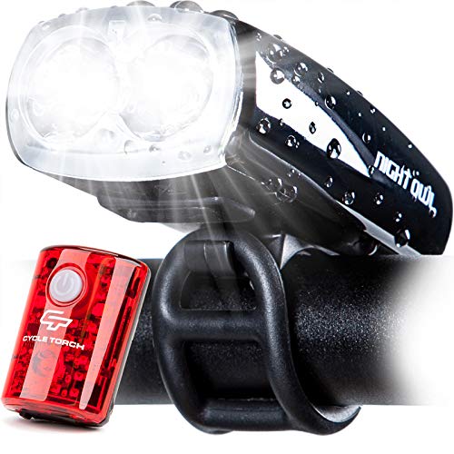
I have a headlamp on my helmet, I got one with a zoom lens which allows me to have bright light wherever I'm looking but without blinding passing drivers and other cyclists. It also has the added benefit of that I can zoom it way in tight for a bright white dot a good 30 feet in front of me, which tends to get the attention of pedestrians from behind.
Here's my favorite dirt cheap one
I get about 8 hours out of that on a full charge, and I have no problem riding in total darkness.
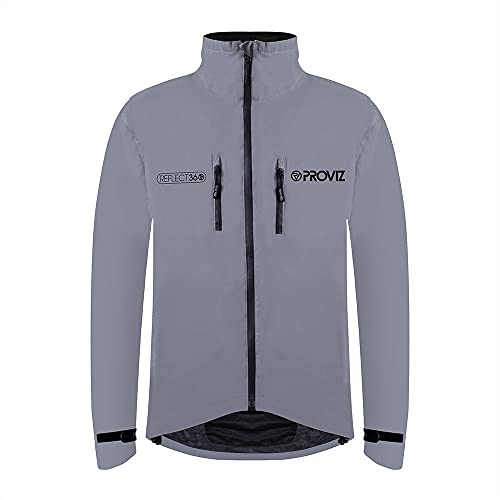
I would also highly advise a reflective jacket too depending what part of the city your riding in.
I got one of these a few months ago and they are incredibly reflective and warm thanks to the glass bedding.
https://www.amazon.com/Proviz-Reflect360-Mens-Cycling-Jacket/dp/B00LD82CAY?th=1&psc=1
Shurs Ln isn't as long as Shawmont, but it's really steep. I live in Wynnewood, so we ride a lot on this side of the river. Plus routes into Delaware County, and across towards Chestnut Hill a bunch.
Ashland Ave is harsh. On our way home, we often take a right on Jefferson, and another right to stay on it past LaCollina restaurant. All the way to the top, then more long climbs up Woodbine. I hate that route.
You can see a lot of our rides at https://www.strava.com/athletes/759248
So, I just suggested a similar ride in another thread - but if you're starting from the art museum, modify the French Creek Iron Tour metric century route so that you're starting from VF instead of Kimberton then when you get back to VF and head home, you'll have a 100 miles when you get to the Museum.
Are you looking to finish in VF? You could adapt the French Creek Iron Tour route - it starts &at stops in Kimberton, PA, but it passes through VF, you could just start and stop there instead of Kimberton.
schuylkill river trail is your best bet. a little annoying at times but still better than the road. bicycle coalition of greater philly has some great routes on ride with gps
some other non completely road stuff not all in philly if you're also interested:
-wissahickon/forbidden drive if you want to try some gravel (and can integrate some mountain bike trails if you want)
-boxer's trail is fun double track/single track that can be done on a gravel bike
-cynwood heritage trail is a fun connector to the schuylkill river trail (paved)
-fairmount around please touch museum has a lot of hills but also some gravel/mountain bike as well (mostly paved but some rough paths)
-delaware canal towpath (never ridden myself but people seem to like it)
-cobbs creek/john heinz (more gravel)
there's a ton of unpaved stuff towards pottstown/allentown/central pa too. the jack a markell trail in wilmington is a nice ride too. valley forge, perkiomen trail, chester valley are all paved ones i've been meaning to try.
Lancaster county?
I did a ride out there last summer that had some good climbs, I can’t find the cue sheet but it was something like this: https://ridewithgps.com/routes/32885777
Just did a century through the Wharton State Forest with friends 2 weeks ago. Pretty flat. Some nice wooded stretches. https://ridewithgps.com/routes/34034125
It’s 106 round trip from the Art Museum. If you start at the BFB it would come out to about 100.
There's a weekly Sunday hill route via Bicycle Club of Philadelphia with a great ride leader and a wonderful group of folks. Usually leaves at 9am from the Art Museum fountain. You can find more info on the BCP website, but if you just want the routes most of them are available on the ride leader's RWGPS profile.
I started trying to describe it and realized it would just be confusing. This should get you from Betzwood (the trailhead at the entrance to Valley Forge) to Blue Marsh Lake (my destination): https://ridewithgps.com/routes/33117491 - the link has a map and a cuesheet.
The first place of confusion is getting from the Reynold's Dog Park at the edge of Phoenixville onto the next section of the trail which starts right at the end of downtown Phoenixville. This involves following either Port Providence Road or the Mont Clare Canal section of the SRT for a few miles, then crossing route 29 to find the next section of the SRT.
The next will be getting from Parkersford into Pottstown while avoiding Route 724 as much as possible by using Old Schuylkill Road. Once you're in Pottstown you can get back on the trail again and follow it to Birdsboro.
You'll end up back on the road there, for a short while, but soon you'll be on your way to Reading and beyond.
There are a bunch of great routes sprinkled throughout the BCP ride calendar. The Dirty Thirty is a nice short one if you're not averse to a bit of climbing.
There are a ton of good routes on ride with GPS, this one is a bit shorter than what you're looking for but has a ton of climbing: https://ridewithgps.com/routes/28352976
As for small group rides, I'm staying solo for the time being, sorry!
I used to commute to Narberth every day and would usually go through overbrook before I learned some easier ways to avoid traffic and crazy commute drivers. I'd do something like this if I was you: https://ridewithgps.com/routes/30819259
Remington Rd. is usually pretty calm, and this routes around most of S. Bowman, except for the bridge, which is a pain in the ass to get over. There's a sidewalk if you're not comfortable on the shoulder there. Another problem spot to watch out for is near Produce Junction where nobody has any idea what's going on. Should be fine in the morning when they're closed but the evenings might be a mad house. It's also possible to bypass by continuing down Wynnefield to 51st.
It is possible to take N. Highland to the Cynwyd trail, but that route will be a pretty long ride.
I did it a few years ago by riding out to wharton state forest, going down 206 past Hammonton, making my way to tuckahoe road and cape may ave then through the bellplain state forest, then finally taking 347/47 down to bayshore road. The only trouble I had was that the road through hammonton turned into a shoulderless like 50mph road, so I had to backtrack a bit and improvise. Other than that you're mostly on state roads through the country with wide shoulders. Super fun ride. I ended up changing the route a bit, here's the new route that I am going to roughly follow this summer. A lot of those roads through wharton are sand. I think the section from philly to wharton is about the same as what I rode last time.
My friends and I do an annual overnight ride to cape may every year! Here's our route - https://ridewithgps.com/routes/28657727. In years past, we've ridden up to AC to catch the train back. It's a very pleasant flat 40mi up the coast and WAY better than taking a 3 hour bus ride back home. Last year we ended up just camping across the bay in DE and riding back the following day. Glad to answer any questions you might have about the route/ride!
If you're from SF, you probably know how to ride hills. The Schuylkill River Trail (SRT) is a leisurely ride that keeps you off the street, but it's also dead flat and mostly boring.
If you're comfortable riding on the road with cars, albeit mostly quiet 2-lane suburban roads, I have a 35-ish mile (from center city) loop out through Havertown, Bryn Mawr and Haverford (suburbs to the northwest of the city) that you can knock out in about 2-2.5 hours depending on fitness. There's a moderate amount of climbing and a nice mix of terrain and scenery.
I feel that it's relatively safe due to the sparse traffic, and it has become my go-to solo road ride through the pandemic.
Here is the current Komoot route which is a mix of all the “suggested” routes. I believe the Taconoy-Palmyra was simply a middle ground between riding all the way into Philly vs crossing into jersey from my location in Langhorne.
Port Royal is... technical.
The cobbles aren't the whole climb but they're the most memorable part. It used to be a lot less difficult, but the cobblestone bits have been sinking and sliding and buckling, and the asphalt patches almost make it worse.
But yeah, the Dirty Dozen is a solid ride with some nasty climbs. At least they're nasty when you do them all in a row.
Here's my route from the 2018 Dirty Dozen. I can't remember if this worked out to 13 or 14 hills, but it's a doozy. You might have to create a free Komoot account-- if you can't get the file, let me know and I'll see if I can directly share the GPX file.
I'm not group-riding with anyone, but I have a pretty solid route I can share with you that meets the easier end of your specs. It should be easy to follow if you have a computer that does turn-by-turn directions.
The ride leaves center city and heads out through Wynnewood, Radnor, Willistown and Conshohoken for a total of 50 miles and 2,000 feet of climbing. It has some beautiful scenery and good, but not nasty, climbs. Sawmill is a favorite.
It briefly dumps you onto Newtown Street Road / Darby Paoli Rd which is a 4-lane road with a big shoulder, but I think you're only on it for a mile or two before you turn off onto a quiet 2-lane road again. When riding solo it's more important than ever to bring your blinky lights and run them even in the daytime. Visibility is crucial.
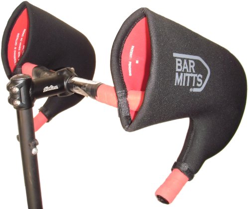
Bar mitts. Neoprene bar and shifter covers. Down to a little under 40 degrees, I've ridden with half finger gloves and my hands have stayed warm. I've gone down to 20 degrees with them and full finger gloves.
https://www.amazon.com/Bar-Mitts-Handlebar-Shifters-Internally/dp/B002VK3SEC
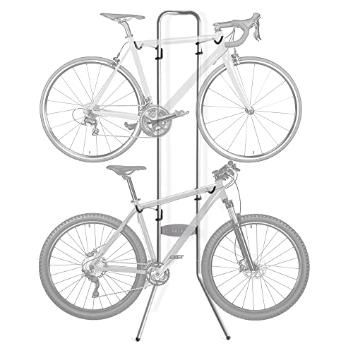
I live in Center City. I use my road bike when I want to go out for a ride. I also have a commuter bike that I use to get to work. I would never want to ride my road bike to work, and I would never want to ride my commuter when I go out for a ride. So I got two of these and I store the bikes standing up in my garage: https://www.amazon.com/gp/product/B07BLG6LKH/ref=ppx_yo_dt_b_search_asin_title?ie=UTF8&psc=1
Not sure of your apartment configuration, but could it accommodate something like this?:
https://www.amazon.com/Delta-Michelangelo-Two-Bike-Gravity-Stand/dp/B000ACAM38
A spare bike can come in handy if you can swing it.
My set up is one on the handlebars (White light), one on the seat post (blinking red), one clipped to the back of my helmet (blinking red). I prefer the on-bike ones for MY vision because they're more stable and at a lower angle, so they tend to show the road a bit better. The red blinkers don't matter as much to me, I've found even the cheap ones help you be seen.
Considerations:
- Brightness (1,000 lumens is preferred for front lights if you have NO lighting on your route, otherwise you can get away with as little as 200)
- Battery set up (most are rechargable these days, but batter life can be an issue)
- Modes (some front lights offer different brightness levels and blinking options, useful to help extend battery life if you're in a well lit area)
- Ease on and off (You'll want to take them off pretty much any time you leave your bike locked up... or at least take off the more expensive front light)
Models I've used:
- Trek/Bontrager makes good ones, I have older version of the ones seen here
- This guy (which was the first one I bought, not as expensive, not as bright, but gets the job done in lit areas)
As I said, rear blinkers come in such varieties that all seem to get the job done... but I like the ones that I've gotten for free from events and that came with other lights from amazon.
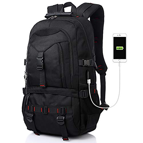
Oh I totally got this! My random laptop sleeve back pack I got on amazon is absolutely perfect for my u lock. With it unlocked, I loosen the bottom two straps and wiggle the locking mechanism through then tighten the straps. The U gets clipped in the strap over the smallest pocket, which is also perfect to clip a light on to. Then lock it up and tighten and it doesn’t even bounce around, it’s great. I can send you pictures if the way I described it was confusing. link here
I've been using a kmc single speed chain for the last 2ish years, it's on the lower end but if you degrease and lube every once in a while you should be fine.
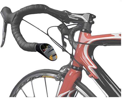
I salvaged this out of road shoulder debris: https://www.amazon.com/Zefal-471001-Cyclop-Bicycle-Mirror/dp/B0010VTQBM The bar attachment part isn’t there. I’ve had it wire tied onto my drop bars for ~4500mi and it’s indestructible.