
What are
/r/Adirondacks'
favorite Products & Services?
From 3.5 billion Reddit comments
The most popular Products mentioned in /r/Adirondacks:
![Adirondack Park [Map Pack Bundle] (National Geographic Trails Illustrated Map)](https://m.media-amazon.com/images/I/51+vYm3eLbS._SL500_.jpg)


The most popular Services mentioned in /r/Adirondacks:
OpenStreetMap
AllTrails
EveryTrail
Locus Map
TripAdvisor
Ride With GPS
Gab
Weather Underground
ImgBB
Google Maps
Geocaching
MapMyRIDE
AccuWeather
The most popular Android Apps mentioned in /r/Adirondacks:

Relay for reddit

Locus Map Free - Outdoor GPS navigation and maps
The most popular reviews in /r/Adirondacks:
These are the two easiest Adirondack High Peaks. Cascade offers beautiful views at its bald summit. You could opt to only do Cascade but from the fork, Porter is so easy and close. There are easier hikes to do for sure but for a bit of a challenge that is easily done and a little bit of Adirondack prestige, this is the hike to do.
FWIW, most of the 46er peaks have partially or completely wooded summits.
Mount Colden's summit is partially wooded and the most unobstructed view is towards the west. However, it's a grand, 180-degree view from Flowed Lands and Marshall in the southwest to Cascade and Big Slide in the northeast. It's a 'front-row seat' for the MacIntyre Range and not a view to be missed.
If you stand on its summit marker (a small triangle carved in the rock and circumscribing a drill-hole that once held a survey bolt), you get a decent view of Marcy in the east. Of course, you'll get an unobstructed view of Marcy (and more) near Colden's northern "false summit" where the L. Morgan Porter Trail turns from west to southwest.
To be precise, it's the former fire-observer's cabin (fire tower on Mount Adams) along the East River Trail.
https://www.openstreetmap.org/?mlat=44.07890&mlon=-74.04189#map=18/44.07890/-74.04189
The Allen Mountain Trail starts at a junction along the East River Trail, a few miles east of this cabin.
Nice photo but one helluva fish-eyed view! There's no "smile" in Lower Ausable Lake! :)
For the people who've never seen it, the southern end of Lower Ausable Lake has a gentle bend and is not curved like a banana.
Lake Colden (and Marcy Dam) are absolutely MOBBED on holiday weekends. Sometimes the rangers have to go around and double/triple/quadruple people on the designated sites. I have witnessed this in person. It's a beautiful area, but I would strongly advise avoiding it this weekend. Midweek is generally fine, no matter what month.
​
As for bear canisters, they are required by law in the high peaks and the rangers WILL throw you out if you don't have one. Lake Colden is heavily patrolled and on a holiday weekend, the rangers WILL come through your site at least once (but likely several times). As it is a heavily used area, bears tend to appear there every summer to feast on people who leave food unattended.
​
I don't want to discourage anyone from experiencing the Adirondacks, especially these two incredible locations, but you really won't enjoy it on a holiday weekend, and the regulations exist for good reasons. There are plenty of alternative campsites (and established campgrounds) around. The Adirondack Loj campground is great (but probably already fully reserved). Lake Harris is a nice, quieter DEC campground. And there are plenty of other "designated site" around in the High Peaks that will have less competition for sites.
​
This map shows most of them when zoomed in to this level:
https://www.openstreetmap.org/#map=18/44.11985/-73.98189
​
(Note: I've centered it on Lake Colden, but you can click & drag to explore nearby)
My wife and I did Owl’s Head Lookout a few weeks ago and it was a great shorter hike in the high peaks. We basically had the entire trail to ourselves as well as the summit when we got up there. Plus, parking was no issue as we got to the trailhead around 9am and were the first ones there.
Tough to beat the views for the level of difficulty and length of the hike.
https://www.alltrails.com/trail/us/new-york/owl-head-lookout
I believe there is currently four. Maps have traditionally gotten the number incorrect, for a few reasons- for one thing, the total number has decreased steadily over the past few decades (from something like 8-10+ back in the 70s), and so maps that haven't been updated in a few years often showed more lean-tos than actually existed some had been removed. There's also been some confusion with the Hudowalksi Lean-to, which some people count as a numbered Marcy Dam Lean-to and some people do not. For years, when there was 5 lean-tos at Marcy Dam, the Nat Geo maps showed "Marcy Dam #1-#5" plus the Hudowalski Lean-to. In reality, it was "Marcy Dam #1-#4" plus the Hudowalski Lean-to.
Open Street Map, which is kept current by members of the hiking community, shows 4 lean-tos at Marcy Dam.
However, I know that the DEC has plans to remove another of the 4 remaining Marcy Dam Lean-tos and replace it with a brand new lean-to, further east along the VanHoevenburg Trail, along Phelps Brook. I know that demolition of the Marcy Dam Lean-to (not exactly sure which one will be removed) is scheduled to begin pretty soon- it may have started already.
Not allowed in Wilderness areas because of the regulation against the use of motorized equipment. So unless the drone is powered by a wind-up rubber-band, it doesn't get to fly in a Wilderness area. ;)
Bloomingdale is just outside the northwestern border of the McKenzie Mountain Wilderness area. My guess is the photo is of the Saranac River and taken near Moose Pond Lane. This is just outside the boundary of the Wilderness area.
I posed this question to Magic Eightball "Is there space at Lake Colden?" and it said: "My sources say no."
A second try produced: "It is decidedly so."
So there you have it, Schrodinger's Campsite, there is/isn't space and you'll only know for sure if you go Saturday! ;)
Best to know where all the sites are located in advance to avoid wasting time searching for them. The last time I checked (over a year ago) there were 12 sites in the vicinity of Colden Dam. The DEC may have relocated/closed some campsites since my survey.
2 are west of Cedar Point Lean-to.
1 is north of Herbert Brook Lean-to
5 are in the vicinity of Opalescent Lean-to
3 are southeast of Colden Dam.
1 is on the eastern side of Lake Colden.
There are also 2 sites north of Calamity Lean-to. One is (was?) located on the shore of Flowed Lands (the only designated site with a lake view). There's one more site northwest of the Lake Colden Interior Outpost (a nice site with a flat, pebbly spot for a tent).
My choice would be this site, southwest of Opalescent Lean-to. It's small and very private. It's a short walk away from the broad, open Opalescent River which offers a nice rocky beach for cooking supper and for star-gazing.
Make sure you cook far away from your campsite and store your bear canister more than 100 feet away from your tent. This entire area is frequented by bears so the less interesting you make your site to them, the quieter the night's sleep you'll get.
Good luck and enjoy!
Spectacle pond is a great little hike. ~3-4 miles round trip and unbelievably pleasant. There are also a few nice ones off of Rt 74... The Short Swing Trail into the back of Rock Pond (be sure to take the detour to see the waterfall. If you geocache - Rock Pond Falls) is about 7-8 miles of easy/moderate hiking. Arnold Pond is also pretty cool - short and steep (1 mile each way) but worth it. I've heard Severance Mountain is nice, but I've never done it. Treadway Mountain is probably the best mountain in the area that isn't Pharaoh, but it leaves from the boat launch at Putnam Pond Campground so I'm not sure if it counts as "near schroon lake". Have fun!
That's the usual loop-route, done counter-clockwise as you intend to do, or clock-wise.
Just south of Lake Arnold, when you begin to descend into the Opalescent valley, there's a nice, but brief view, of the area. That's about it. Beyond it you'll cross over a bridge that has shifted position substantially and then through an exceedingly wet area featuring the "floating bridge" (free-floating, loose planks). Do your best to avoid falling in here because the water is allegedly waist-deep. Then the trail becomes nicer, and a little more scenic, along the way to its terminus with the Mount Marcy Trail.
BTW, before you descend all the way to the shifted bridge, keep your eyes peeled, along the right-hand side of the woods, for the base of Colden's Southeast Slide. You can access it (short walk through the woods) for a nice place to pause for a break and for views of the upper reaches of the slide. It's well worth the diversion because there's not much else to see from about Feldspar Lean-to all the way to Lake Tear.
Good luck and enjoy!
As long as you follow the 150-foot rule (~46 meters) and LNT principles.
In the HPWA (and most other areas), you are allowed to primitive-camp (i.e. find a suitable camping spot in the woods) as long as it's more than 150 feet away from trails, roads, water, lean-tos, designated campsites, etc.
Alternately, you can camp at sites designated by the DEC (aka "designated campsites"). They're marked with a yellow "Camp Here" disk and >90% of the designated campsites in the HPWA are marked in OpenStreetMap.
Only the two most popular trailheads charge for parking (ADK Loj and the Garden). Parking at all other trailheads in the High Peaks region is free.
Here's a concise, categorized summary of regulations and guidelines for the Eastern High Peaks Wilderness Area. The eastern HPWA is more regulated than the western half.
FYI
This photo was taken from an off-trail location. Off-trail travel (bushwhacking, rock-climbing) is not permitted in the Ausable Mountain Reserve where Rainbow Falls is located.
I contacted an authority on the subject (local resident, guidebook author, map editor, and much more) and received confirmation there is no official trail beyond the one that leads to the base of the falls.
Please respect the AMR's rules. There have already been instances where private landowners in the High Peaks have either restricted access to their property (Owl's Head) or banned it outright (Little Porter Trail; access to Porter Mtn from the Garden). It would be a shame if the same happened in the AMR all because the general public fails to follow simple rules. Be advised that the AMR's staff has escorted rule-breakers off their property (rules are posted at the trailhead and available as a pamphlet from the guide's booth in the parking area).
If you don't want to part with $5 to star-gaze, you have two nearby free options:
Drive ~1/4 mile south along Adirondack Loj Road, pull over onto the shoulder and look up. Completely open-sky viewing because there are only fields nearby. Only drawback is that a passing car's headlights may ruin your night vision.
A better option is to continue south on Adirondack Loj Road then turn left onto Meadows Lane (unpaved). Continue to the South Meadows Parking Area at the very end of Meadows Lane. For best results, walk about a hundred yards along a trail though a grassy meadow to the footbridge over South Meadow Brook. Nice open-sky views from there and easily as dark as Heart Lake.
Enjoy!
Here you go. This is just one of many.
Tick Tornado ZenPet Tick Remover for Dogs & Cats & People - Value Pack - Easy and Fast Tick Removal Tool https://www.amazon.com/dp/B010NU1V1I/ref=cm_sw_r_cp_api_glt_fabc_CKCBEK33KNR9YNMT06YP
I purchased a NatGeo Adirondack map on amazon for like $11. Has every road, trail, and camp site depicted. Highly recommended for planning trips.
Here is the whole bundle, or you can purchase sectors individually: https://www.amazon.com/Adirondack-Bundle-National-Geographic-Illustrated/dp/1597752258/ref=nodl_
With that being said, Moose river plains may be a good start.
https://www.alltrails.com/trail/us/new-york/wright-algonquin-iroquois-gray-skylight-marcy-loop
Marcy, Skylight, Gray, Algonquin, Iroquois, Wright.
Depending on how fast you want to go you can do them in either 2 or 3 days.
From the Upper Works trailhead, you can get any of the peaks in the Lake Colden area as well as heading over to Marcy and everything over there. Colden, Cliff, Redfield, Grey, Skylight,Marcy, etc. On the other side, Marshall, Iroquois, Algonquin, Wright, Colden, Tabletop, Phelps. If I remember correctly, you have a 6 mile or so mile relatively easy hike into the Flowed Lands and Lake Colden area. From there you can decide how far you want to go. I'm sure there are other options.
I've only been that way once or twice, but now that The Garden trailhead parking lot will be closed for the summer, I plan on using Upper Works a lot more.
Check out the Open Street Maps website. It's a great resource for planning hikes. https://www.openstreetmap.org/#map=16/44.0917/-74.0562
There are trails along fairly level terrain on the private land of the Adirondack Mountain Reserve (AMR; open to the public but familiarize yourself with its rules which are posted at the main gate). You can make an easy loop of the East River and West River Trails, crossing the river at the second bridge.
This area is run by the Ausable Club and public parking is a short distance to the east. From the parking area, you have to walk along Ausable Club Road (and up the hill) to get to the Lake Road and the main gate. FWIW, you can also walk the full length of the Lake Road (5.6 km) to see Lower Ausable Lake and the dam (note: the trip involves an ascent of ~230 meters.
Please note that in the AMR and in the High Peaks Wilderness Area, you must wear snowshoes (or skis) if there's 8"+ snow on the ground. If you and your family don't have snowshoes, and there's 20+ cm of snow, you'll have to rent them. If you're spotted post-holing along trails by a DEC Ranger, you run the risk of being fined $250.
Do me a favor, when you go, take a walk around the area and count the number of lean-tos you see. The last time I surveyed them was ~ 2 years ago. I found 4 lean-tos, logged their names and locations, recorded a track of the trails leading to them, and that's what I entered into OpenStreetMap.
Marcy Dam #2 is on the east side.
On the west side, there's Marcy Dam #4 and #5 and, off to the southwest and deep in the woods, is the Ed Hudowalski Lean-to (the husband of ADK 46er historian Grace Hudowalski).
Having said that, I too have heard the buzz mentioned by /u/DSettahr that they plan to rearrange the furniture. I heard one lean-to is slated to be moved and they might have already done it. My guess is it'll be either Marcy Dam #5 or #4.
If you discover one less lean-to, I'd appreciate it if you report it here in this thread (I'll update OpenStreetMap accordingly). Also, if you have time, check out the area just north of the Interior Outpost.
Just head north along the Truck Trail and keep your eyes peeled for signs of a new trail on your right. I believe it is north of where the foot bridge enters on your left and the outhouses (on your right). It may lead to either new campsites, the relocated lean-to, both or neither! If you have a GPS and can record the position of things you find (or that are now missing), that would be best. If not, that's OK too. Thanks!
There are no campsites at Fish Hawk Cliffs. That area is located on the private land of the Adirondack Mountain Reserve. You can't camp anywhere in the AMR.
You may be thinking of the DEC designated campsites along nearby Gill Brook. Those three sites are on state land (now part of the High Peaks Wilderness Area). The woods there have trees suitable for hammock-camping.
Summit Rock is just off the main trail but we're talking about less than a hundred feet.
Based on what I saw June 2016, the trail-junction is marked with a sign and there's a three-rung ladder, within sight of the sign, to help you get up a small ledge. FWIW, I'm an OpenStreetMap editor and I mapped all this info.
The view from Summit Rock is pretty (Santanoni Range and more) but what I found to be more remarkable is in the foreground. There are house-sized boulders at the base of Wallface's cliff. The trail also passes a boulder that is easily the size of a three-storey building.
EDIT
You many be interested to explore an old airplane wreck in Cold Brook Pass. It's just off the Cold Brook Pass Trail but you'll have to continue east, past the junction with the Marshall Trail, for a few hundred yards, inspect the wreckage, and then double-back to the junction. It's just beyond a large boulder next to the trail.
I was also going to recommend Hurricane. I've done a lot of hiking in the ADKs and that has one the BEST views of many of the mountains/High Peaks. Plus, it's not a 46er so it's a lot less busy. https://www.alltrails.com/trail/us/new-york/hurricane-mountain-trail-northern-approach
One really good one that is about 11 miles but really not much vertical is the home out to Indian head along the west river trail. Lots of waterfalls to pass and rivers/streams to cross, plus the view from indian head is beautiful. Check out this trail on AllTrails. https://www.alltrails.com/trail/us/new-york/indian-head-and-rainbow-falls
If you are looking for more of a challenge, I would suggest hiking up to Algonquin or Marcy from adirondack Loj and then heading back through the lake avalanche trail, another gorgeous area!
Don't overlook the fact you'll need to leave Montreal at ~03:00 to get to there for day-break. Starting at sun-rise is a good idea and you might consider leaving Montreal this evening and camping tonight in the ADK Park in order to avoid a pre-dawn drive tomorrow.
There's Draper's Acres close to the Loj and KOA campground in Wilmington. There's free camping along Meadows Lane but all sites might already be occupied (it's a holiday weekend after all).
Nat Geo makes a Six piece series that covers the whole park. Adirondack Park [Map Pack Bundle] (National Geographic Trails Illustrated Map) https://www.amazon.com/dp/1597752258/ref=cm_sw_r_cp_api_i_7wyJCb0HJJBE0
Here is a guide that's a good start. Others will likely share tandem trips that they have done, and many combinations are possible but it will be determined by your schedule, abilities, conditions, etc. In addition to Cascade and Porter, Street and Nye are almost always combined. There's a ton of sources out there if you keep looking.
I second the Ausable Brewing company, it's just got a nice relaxed vibe. Ausable Chasm is for sure worth checking out.
if you're looking for some day hikes in the immediate area, Pok-o-Moonshine is probably the most popular option.
If you're up for some more serious hiking or wanna check out some of the easier high peaks you're about an hour away from ADK Loj and the Porter/Cascade trailhead as well as many of the other high peaks hiking areas.
​
Edit: porter and cascade trail overview / directions
and a big ol list of ADK LOj based hiking choices. (On the bottom right of the map Click "overlays -> show nearby trails" for a bit ol list of available stuff or build your own hike!)
AllTrails will show you nearby trails - it's one of their map overlays. Looks like Wakely Mountain (which has a fire tower) is the southernmost right off the NPT. Blue Mountain (another fire tower) will be a bit out of your way, but only 4ish miles each way.
Trailhead is right by Route 28 between Blue Mountain Lake and Long Lake. https://goo.gl/maps/DmqXgEqtaso
And here's more info and what other people say about the trail: https://www.alltrails.com/trail/us/new-york/blue-mountain-trail-to-blue-mountain-fire-tower
Have a great time!
I also come in from the West. I always go North from Utica through Old Forge and up to Saranac Lake / Lake Placid. You can access the high peaks trails north of Newcomb if you don't want to drive all the way around to the North or East. I've never hiked from there, but you can. Still looks like ~3.5 hour drive though. I'd check the proper high peaks map to be sure of what you can to from there.
​
Coreys Road, in the Western High Peaks Wilderness Area has several, free, roadside campsites. Campfires are still allowed in this area.
If you plan to go there, be advised the campsites are popular with hunters at this time of year (hunting season) so availability may be very limited.
ADK Loj's campground ("Wilderness Campground at Heart Lake") is located at this map marker.
The main trailhead is located at the eastern end of Parking Lot #1. That's about 400+ feet from where you'll be camping.
You can buy a map of the area, and other things, at the High Peaks Information Center (the "HPIC") which is located at the western end of the same parking lot.
Enjoy your visit!
No insult was taken.
I believe the lean-to you're thinking of is Opalescent Lean-to. It's not along the Mount Marcy Trail to Cliff, Redfield, etc. It's 500 feet southwest of Colden Dam (as the crow flies). The fastest way there from the Dam is to ford the river along an established trail. Alternately, you can cross the suspension bridge then double-back using the trail running alongside the river.
There definitely is a trail from Marshall to Cold Brook Pass. It's an unmarked, minimum-maintenance trail, just like the Herbert Brook Trail. The Marshall Trail is the route I used to get to Marshall the first time I ascended it, decades ago. My last visit was this past fall and the trail not only exists but is experiencing increased traffic.
+1 to /u/arcana73 's suggestion.
>in the Eastern High Peaks you are only allowed to camp at designated camp sites.
Not quote yet; you're still allowed to primitive-camp "at large" in the Eastern HPWA (> 150 feet from trails, lean-tos, water, etc).
In the 1999 Unit Management Plan, there was mention of potentially restricting camping to designated sites within the South Meadows thru Flowed Lands Corridor. It never came to pass but there is renewed interest in this strategy once again (i.e. in the latest UMP).
Having said that, the Corridor is very popular and, for the sake of the resource, campers should strive to camp exclusively at designated campsites.
That's a unique POV.
It's not from the Rainbow Falls Lookout.
It's not from the viewpoint on the Lost Lookout Trail.
It's not from the level of the Rainbow Falls Trail either; it's from above.
How did you take this photo?
I can't link to Essex Country GIS so here's a screenshot of the property lines near the spot where you wish to camp. The area bounded by pale-blue lines is owned by the state and you can primitive-camp there. However, the next parcel of land south of Bennie Brook is privately owned (no camping; only allowed to pass through along the trail). Therefore camping in the woods along Bennies Brook (upstream of the Southside Trail) should be fine.
In case you don't know, the Southside Trail no longer receives maintenance (not since 2011). It's still passable but a section was washed out right at this dogleg in the trail. You'll know it when you see it because the trail up to that point runs along rocks directly in the brook then seemingly ends at a pool of water at the base of a rockface. You have to scramble up the steep rocky bank (the zig in the dogleg) then swing back to the original trail (the zag in the dogleg).
If you don't mind me asking, after ascending the slide, what's your planned route to Slant Rock?
There's at least one designated campsite not far from Panther Gorge Lean-to and there may be a second one. Marcy Brook is your source for water.
If all designated campsites are occupied (first-come, first-served; max 3 tents per site) you can primitive-camp provided the site you choose is more than 150 feet from trails, lean-to, and water.
Don't forget this is in the Eastern High Peaks Wilderness area where it's mandatory to store your food in bear canisters and campfires aren't permitted.
Enjoy your trip!
I'd recommend Peaked Mountain. Frankly, this is always my suggestion for reasonably new hikers looking for an ADK experience as it is not particularly difficult and convenient enough to the Capital Region, yet offers most everything one could hope for in an ADK hike..lakeside, boulder strewn river, beaver ponds, alpine lake, then finally a quick ascent up to the top of a treeless peak offering wonderful views in all directions.
Most of the hike is easy to easy/moderate, but the climb from the pond to the summit (which is only 30-40 mins) is relatively steep, making it more moderate.
The biggest challenge on the hike is route finding near the beaver pond. Follow the blazes, and if the trail is still as it was, you will find the trail covered by water as the beavers had flooded the trail. Not a biggie, just find the blaze on the other side, and take a small detour to find the easiest way across the water, and then back to the blaze that you had eyeballed before crossing. Be sure to check out the handiwork of the beavers while you're here though. You will find many trees, from saplings on up, have been removed leaving pointed stumps and wood chips around. Those little guys are friggin amazing. Also, take a look at the beaver lodge out in the pond for any activity.
Here is the AllTrails listing for this hike.
Remember, even though this is a relatively close and easy hike, that you should still be sure to carry the appropriate tools, including most importantly map and compass.
Feel free to hmu if you have any questions. and if you do go, let me know how you liked it.
Gosh its been 2 maybe 3 years since I've been up Noonmark. It's not bad, just a very worn trail. Its nothing technical, just take it slow and watch your footings. There are several lookout areas along the way up as well as a ladder or two if I recall. I recommend using the website Alltrails. It has pictures of the trail as well as reviews and maps and I find it helpful. (You might need an account if the links don't work)
https://www.alltrails.com/trail/us/new-york/noonmark-mountain-trail
https://www.alltrails.com/trail/us/new-york/noonmark-mountain
I always thought Lake Mary Louise was interesting. It's pretty high up in elevation on the way to Rocky Peak if you're hiking from RT 9, and it's almost a perfect heart shape.
Can you tell me how you know it's a DEC designated campsite?
Unless something changed this year, there's no DEC designated campsite anywhere above 3500 feet in the Dix Range.
If you are specifically referring to the area at the junction of the Lillian Brook Trail and the Dix Range Trail, I've hiked the Dix Range many times over the last 8 years and have not seen a DEC 'Camp Here' marker there.
The DEC's State Land Interactive Mapper (SLIM) does not show a campsite there nor does the Adirondack Mountain Club's High Peaks map (nor does OpenStreetMap).
Page 61 of the 2004 Dix Mountain Wilderness Unit Management Plan discusses the campsites in the area, notably the ones requiring relocation/establishment. Its inventory of campsites does not mention one there nor is it shown in the UMP's map of the Dix Wilderness.
I would like to know why campers who make the challenging trek to this site, firmly believe it's a legal camping spot. Located well above 3500', not designated by the DEC, and not shown on any recent hiking map. Is it just word of mouth that misleads them to camp there?
FWIW, I met at least one group (mid-afternoon at the top of Macomb's slide) who were heading to camp there with full knowledge it was an illegal campsite. They justified their actions by claiming they'd 'camped there before'. Not sure how two wrongs make it right.
The final ~400 meters of the trail are above treeline (and ~90 meters of ascent).
Algonquin is a wildly popular peak. ADK Loj regularly runs out of parking space especially on holiday weekends. Honestly, if you don't arrive before 7:30 AM you'll be parking about a kilometer and a half north near Meadows Lane (parking along ADK Loj Road is forbidden south of this point). Include walking an additional 3 km of hot pavement in your calculations.
If you liked Bald Peak, consider Owls Head Lookout. Great view and the trail crosses at least one brook.
EDIT
In metric because OP is Canadian. In Imperial units, the final ~1300 feet of trail and ~300 feet of ascent are above treeline. If you're unfamiliar with meters just think of them as 'super-sized yards' (one meter is about 10% longer than a yard).
I have no hiking plans for this very hot weekend but if I did, I'd pick a route with lots of water. Not just for drinking but for dipping to cool off (head/feet/whole-body). Above-treeline travel exposes you to additional risks (like no water sources or shade and full exposure to thunderstorms).
Consider it an opportunity to visit waterfalls, rivers, lakes, ponds, and other flat-land hikes you may have overlooked. Adirondack brooks have inviting dipping pools but are often numbingly cold. What better time to use them than during stiflingly hot weather?
Have you visited Shoebox Falls on the North Fork Boquet River? The dipping pools in Johns Brook? Rainbow Falls in the Ausable Mountain Reserve? How about roadside Split Rock Falls?
The Sewards don't dry out quickly and are often muddy even at the best of times. Plan for the worst and hope for the best.
If you to plan to camp in the area, I suggest you avoid doing what everyone else does (camp at the designated sites near Blueberry or Ward brook Lean-tos) and opt for this designated campsite near Calkins Brook Truck Trail. It's located midway between SDE via Calkins Brook Trail and Seymour via Blueberry/Ward/Brook/Seymour trails. Water is nearby and it's a short walk from the trail-head. The site is large and flat and about 150 feet east of the road.
Don't overlook that it's forecasted to be stiflingly hot and humid this weekend. Consider choosing peaks where the route follows/crosses streams so you have ready access to water (for drinking and dipping).
The route to TT+Phelps provides access to water. I would caution you about adding Gray to those two. It means traversing Marcy and those four peaks make for a punishing day when hot and muggy.
You orphaned several challenging peaks! Blake means going over Colvin again (unless you approach from Elk Lake but the ascent and distance is more not less). Couchsachraga effectively means re-ascending most of Panther (I should talk; this also happened to me on my first round). If you went to Skylight without the side-trip to Gray, you now get to re-ascend 95% of Skylight.
Wherever you choose to go, go early. This weekend is Canada Day weekend and there'll be a lot of hikers from Quebec and Ontario. Good luck!
I now you know this but for those who don't, many beginners navigate exclusively by trail signs. They think the trails are marked like the interstate highway system … but they're not.
That intersection has a signpost with signs:
The first shows the distance to Big Slide, Yard, and on to the Klondike Notch Trail, and JBL.
The second indicates the distance to Second Brother and the Garden.
The third sign … well there is no third sign (in August 2017). If there was it would tell you the distance to the Phelps Trail and to JBL (much shorter that via Yard) and possibly even to the Garden.
Without that third sign, "sign navigators" appear to be believe the way to JBL is by going over Yard, like it clearly says on that first sign. If one were to look at a map … well "sign navigators" either don't have one or can't be bothered to refer to it (or have one but would be hard-pressed to explain where they are on it). If one did look at the map, it's abundantly clear that the shortest route to JBL is via the Slide Mtn Brook Trail.
That's a great panorama from Jay Mtn's Lookout!
Did you go to its summit at the extreme eastern end of the ridge? This route and the western half of the East Trail to Giant have similar characteristics (wide-open views along bare-rock outcrops).
I don't know exactly when or where you parked but Ausable Club Road is posted with No Parking signs. Nevertheless, I've seen cars parked along its shoulders despite the signs (and they do get ticketed).
If the Ausable Club Parking Area is full, there's limited parking along route 73 where it's allowed provided all four wheels are off the pavement. The Roaring Brook Parking Area (across the highway) fills up fast so its rarely an option. If the highway's shoulders are filled to capacity (there are guard rails that limit the available space), there are legal parking areas on route 73, the first one being about a quarter-mile south.
https://caltopo.com/map.html#ll=44.14884,-73.76314&z=17&b=sat&a=mba
Having said that, I see more cars parked illegally than at the legal areas a quarter-mile away. Why? Probably not because of the distance but the fact they're ~100 feet uphill. They're avoiding a 10 minute walk to run the risk of a ($60) fine.
A popular place to go for a dip is Shoebox Falls on the North Fork Boquet River. It's not secluded but it's not roadside either.
Having said that, unless you and you're girlfriend are members of the Polar Bear Club, you probably won't want to dip more than your feet in the cold, cold river (it's only late May).
Be advised the trail leading to it (Boquet Forks Trail) is not marked and there are no trail signs. Having modest backcountry navigation skills is advisable. The path is obvious up to the point where it fords the Boquet river (that's where some go astray). If you miss the ford, you'll be following a westerly path ... and you're on your own.
There are many primitive campsites and lean tos along the trails in the high peaks. You may also camp anywhere that is 150 feet from the trail and any water source, however most of the area is pretty dense forest and finding a suitable spot for a tent that meets those requirements can be challenging.
Here is a map that shows where all the campsites are located. They are free but first come first serve. https://www.openstreetmap.org/#map=16/44.1566/-73.9514&layers=N
Also you should know: Bear canisters are required in the Eastern High peaks area, Fires are not allowed, and you can't camp over 3500 ft elevation.
Something I just recently stumbled over is Electrolyte pills. They seem to work great. Also pickles have a large amount of electrolytes.
https://www.accuweather.com/en/us/albany/12210/october-weather/329673?year=2022
The graph at the bottom shows actual October temperatures compared to the average. About half the days were over, half were under....which you would expect since its an average.
https://www.accuweather.com/en/us/albany/12210/november-weather/329673?year=2022
This one is November....you can see the warm spell the past week, but aside from a few days we will actually be below average for the remainder of the month
say more.. flat? climb??
​
do you only mean climbing... there are some cool hikes to ponds in the area
​
https://www.alltrails.com/trail/us/new-york/owen-pond
​
also a cool trail along the Ausable... a flume as well... it goes all the way to the ski center near the Hungry Trout Restaurant
Cobble Lookout has the best view for the least amount of effort of any trail that I know of. https://www.alltrails.com/trail/us/new-york/cobble-lookout-wilmington
​
That being said, you'll need snowshoes or at the very least microspikes/crampons, neither of which I would recommend for somebody rehabbing from knee surgery.
Hands down the Western Ridge Trail, part of Moreau Lake State Park near South Glens Falls. Less than a mile hike to summit. Insane views, especially at sunset.
McKenzie Mountain is a great hike if you are up for it. https://www.alltrails.com/explore/trail/us/new-york/mckenzie-mountain-jack-rabbit-trail
Miles 2 -> 2.5 is very steep, but the rest is a great trail, and I don't think gets a lot of use.
If you look on the map you can see that you can make it a loop as well instead of out and back. Coming down the back side looks as steep but its much different terrain, kind of going through a steep meadow.
MAKE SURE YOU HAVE MICRO SPIKES!
There's various names for them but I've always referred to them as "cats eyes." Hunters use them to mark paths to their tree stands/hunting blinds so that they can easily find their way to them while it's still dark- early in the morning on their way out to hunt and/or late in the evening on their way back from hunting.
They aren't technically legal on State Land (counts as littering and/or marking/maintaining your own trail) but in areas away from popular hikes (i.e., outside of the High Peaks region) it's not uncommon to find them.
Example: https://www.amazon.com/Reflective-Trail-Markers-Marking-Hunting/dp/B07SN71Y26/
I think you would find this an interesting read. It's a fathers journal he kept when he did the 46 with his son. The trail info is somewhat dated, but the insight into the journey is not. I referenced it regularly while doing my 46 with my sons.(only 1 of 4 did them all with me)
https://www.amazon.com/Exploring-Adirondack-High-Peaks-Historical/dp/0962492329
This is a book is a great place to start your journey. Exploring the 46, by James Burnside.
I was looking at that loop! This one right? https://www.alltrails.com/trail/us/new-york/blake-peak-colvin-and-nippletop-dail
Unfortunately, I don't think we'd be able to get up in time Friday to hike to a basecamp before sunset, but we have experience rucking/hiking with significant weight already (despite no backpacking trips yet) so thinking the gear needed for one night won't be too bad.
Also was looking at upper works to Lake Colden. Maybe hike out, set up camp midday, do Colden or Marshall before sunset, and then the other on day 2 before hiking back to the parking area? Any idea how far it is from Lake Colden up either Colden or Marshall? Only map I can find that way on AllTrails is for Marcy.
did this one earlier this summer. highly recommended!
Oh, nice. Will take a look. Might be a bit farther south than I want for this trip, but maybe not 🙂 This is tempting me a lot. Was leaning to maybe this Cranberry Lake hike just because it's only 2hr drive. Seems like might be nice unless those ponds are just bug infestation zones, or there's some reason to avoid this CranLake.
Would be so cool to see a moose... or a bear. My bear can isn't up here in NY with me, so I'm going to bear bag hang. How's the bear population around CranLake or the West Can/French Louie Loop?
I think that the West Canada Lake loop, aka French Louie loop, sounds like it would be perfect trip for you. It is one of my favorite hikes for a three or relaxing four day trip - great hiking, some beautiful leantos, and a healthy moose population in the area.
https://www.alltrails.com/trail/us/new-york/west-canada-lakes-wilderness-loop
We have a place on the GSL so I know this area well.
Hike Spruce Mountain - it's a short and relatively easy hike up to the tallest fire tower in the Adirondacks. Hadley isn't far but it will be packed if you go on a weekend.
We also discovered this hike recently. It's not the most interesting hike in the world but the overlook offered some neat views. It also connects with the Western Ridge trail if you want something longer.
For more scenic walks in the wood vs. true hikes, check out the Saratoga PLAN properties scattered south of Corinth.
Thanks! Openstreet wasn't loading so I made a map on Alltrails - is this what you had in mind? https://www.alltrails.com/explore/map/map-fca758e--31?u=i
And any good websites for recommending where to find other lean-tos or stealth sites?
Thanks guys for your responses. I too was looking for this information, and after your advice looked into that trail and it looks like something I might try soon!
Got some info from people who hiked it recently as yesterday too!
There's not really any official 40 mile loops. Your going to have to get creative. Keep in mind that elevation is far more important then mileage. That said here's a loop:
Start at elk lake>over haystack to uphill lean too
wolfjaw trail>hike to st huberts>old dix trail>boquet lean to
back to elk lake
I didn't calculate mileage but this is close to 40. You pass tons of peaks you can grab on the way if its too easy.\ I might do this actually haha
https://www.openstreetmap.org/#map=13/44.0973/-73.8261&layers=C
The only place I know near there is on Indian Lake, but you'll need a boat to get to it. There's about 15ft - 25ft high cliffs. It's right about here.
If you don't mind going further north there's Bluff Island on Lower Saranac Lake which has cliffs from about 20-70ish ft. Or there's a spot on 86 just east of Whiteface.
Looks like it's supposed to snow this weekend so make sure you got the right gear/footwear for winter camping and Hiking.
Without knowing your past hiking and camping experience and fitness it's hard to suggest things. Generally I would recommend NOT doing a loop the first time in a new environment as you don't want to be over a day away from civilization if you accidentally end up in over your head.
The classic is to use Marcy Dam as your base to do hikes like Phelps n Table Top or some combination of Marcy / Gray / Skylight. You could also hike and camp at Avalanche pass or Lake Colden from which you can hike Iroquois, Algonquin or Colden.
I recommend messing around with that all trails app/website linked above so you plan your own trip and i highly recommend building a few different length options so you can adjust based on how your feeling / how fast your moving.
Most of the designated campsites in the High Peaks are indicated in OpenStreetMap. Here's are the lean-tos and campsites near Avalanche Camp.
The branding on these amazon pants is tacky, but I got a pair and they're surprisingly good: https://www.amazon.com/gp/product/B07BW8K2TB/
The thigh pockets are mesh lined, so they act like vents though I can't personally attest to how much air they actually move.
I wonder how it would be wearing zip-offs and just half-unzipping the legs for more air? Or heck, unzipping the fly too.
Best ones ive found yet. Ive seen companies charging $190 for identical pants stich for stitch.
These are $40. I have 2 pair and swear by them. Had 2 family members purchase a pair as well and they love em.
Rdruko Men's Snow Ski Pants Waterproof Softshell Outdoor Hiking Travel Fleece Insulated Winter Pants https://www.amazon.com/dp/B07XT2G5QJ/ref=cm_sw_r_cp_apan_glt_fabc_VNPFF4H8PBA1G8P0KN10?_encoding=UTF8&psc=1
Hurricane Mountain & Fire Tower is the first that comes to mind.
https://www.alltrails.com/trail/us/new-york/hurricane-mountain-trail-northern-approach
If you look at AllTrails, it'll show you the elevation at any given point.
For example, taking the out & back Van Hoevenberg Trail, you reach an elevation of 3,500 feet at approximately 4.2 miles: https://www.alltrails.com/explore/trail/us/new-york/mount-marcy-via-van-hoevenberg-trail?ref=sidebar-view-full-map
Check this out. Closer to you, and definitely manageable this time of year.
http://www.offonadventure.com/2014/04/blueberry-hill-trail-system.html?m=1
there is a lean-to with an excellent view (I stayed there last year) and it was not a difficult hike in. There are also mountains to hike nearby:
I would be with 2 other people who have also done overnight hikes before. Is this the campsite you stayed at?
I noticed on openstreetmap that there is a campsite there, I'm just not sure if that's accurate.
The odds of getting a parking space this evening are better than tomorrow evening.
It is private property so if the guard insists you turn back, you have no option. However, the reason for turning someone away is if they appear to be unfamiliar with Ausable Mountain Reserve's rules and are liable to camp within it. You need to demonstrate you're not one of those people. If challenged, explain you're familiar with the AMR's no-camping rules and you're headed to one of the three designated campsites along Gill Brook which is on State land.
Following the Lake Road is easy. I would suggest using the Gill Brook Cutoff Trail vs Gill Brook Trail. The first site is across the brook and is the largest of the three. The other two are smaller. Make sure you have a detailed map and a strong headlamp because the spur-trails leading to the sites aren't obvious in the dark.
FWIW, if you're heading out today, you also have better odds of getting a parking space at the Garden. The campsites along Gill Brook are better suited for a tour of Indian Head, Colvin, Blake, Nippletop, and Dial. They're not optimally located for the Lower Great Range.
In fact, you will have to climb ~360 feet from the Lake Road to get to the first campsite. You'll be ascending/descending that 360 feet several times over the course of your trip. That's why I suggested camping in Johns Brook Valley where there are many well-located options for camping.
There are free, designated campsites along route 73 between I-87 and Keene Valley. Some are drive-up sites. The greatest concentration is near Chapel Pond. The closest one to I-87 is along route 9. Camp at one of them and get an early start the following morning.
https://www.openstreetmap.org/#map=17/44.11904/-73.98119
This map has the lean-to's and campsites listed.
It's a very pretty area, but there is high bear activity, you really need an approved bear can for your food (they rent them at the loj for $8 a day) and keep it away from where you sleep, don't bring any food there. Most people choose to eat at the dam (just a minute down the trail) it's scenic and away from the lean-to's.
Beaver point was really nice, there were 3 of us, we showed up around 2:30pm and had only one other person to share the lean-to with, most people saw there were 4 sleeping bags and went to look elsewhere.
/u/LookingForViews also recommended Herbert Brook lean-to as being very scenic.
​
The Seward Trailhead. It's indicated on the linked map.
If you're having trouble viewing it (it doesn't render well on mobile devices), it's right here.
Nippletop trailhead has several peaks out of. You could do the Nippletop loop, catching two peaks (Nippletop and Dial) and a lesser hill (Bear Den).
Out of that trailhead you could camp overnight off trail or find a lean-to, and then hit up several other peaks out there.
Another great trailhead is Adirondack Lo j. I’ve done a day loop out of Phelps, Table Top, and Marcy, but there are several options you could do out of those.
https://www.openstreetmap.org/#map=13/44.1286/-73.9159&layers=CN
I’ve throughly about doing another loop out of there and hitting Phelps, Table Top, Marcy and then sleeping the night out there to hit up Haystack, Gray, and Cliff. Then spending another night to hit up Colden and maybe Avalanche.
Check out that Open Street Map, it’s sweet and has been referenced on here before. All Trails is not bad, as well.
>Will probably avoid it and stay on track towards Algonquin, which I hear has a more rewarding view (would you reinforce this claim?)
Absolutely. Algonquin's peak has the best view of all the high peaks imo. Wright's was kind of underwhelming since Algonquin sort of towers over it.
>I run 5 miles in 40-50 minutes
You'll be fine then. From the Loj, it should take you maybe 3-4 hours to the peak. Start at the trail at the back of the parking lot, turn right at the junction towards Algonquin a mile in, walk for a while and you'll see a waterfall on your left, then you'll get to the Wright/Algonquin junction -- Wright on the left, Algonquin straight ahead. You'll run into a few false summits right before the top, but you'll know when you reach the real one.
Here's a map for you, the two stops are Algonquin and Wright: https://www.alltrails.com/explore/recording/algonquin-and-wright
Where is a good place to overnight and what are some good routes in the Dix range? I'm very open to doing a round trip carrying tents and gear, rather than dropping gear. This(http://www.everytrail.com/guide/the-dix-range) looks like a good route, but I would prefer a overnight location that's closer to halfway on the trip. Thanks for the input.
yeah no problem! i sort of covered some of your questions in my response to the OP. i think that the loop might be a solid option for you. take a look at this, though i personally prefer doing the loop in the other direction. that will be more interesting than a straight out and back hike, especially because avalanche pass is pretty awesome. plus having the options of doing side trips for wright and iroquois give you a way to scale the difficulty to what you feel is appropriate. marcy is great, but as you mentioned the challenge of marcy is more in the distance than the trail itself and you would probably have to return on the same trail you hiked in on. this loop should make things more interesting for you.
Yes, it is possible to map springs in OSM.
https://wiki.openstreetmap.org/wiki/Tag:natural%3Dspring
Here's one located in northern Maine.
I haven't done an extensive survey of springs in the High Peaks. In addition, every trickle of groundwater does not make for a reliable source of potable water. I feel it's safe to assume that if people see "spring" on a map, they'll assume it's a source of potable water.
For example, there's a spring along the Algonquin Trail above the junction to Wright. The water runs out along the trail, on bare-rock, and frequently contributes to creating muddiness downhill near the junction. I could mark that spot in OSM … but is it reliable and is it safe to drink unpurified? I can't answer that so I hesitate to include it in OSM.
It's located everywhere on Instagram and Facebook. /s
… but seriously, Indian Head is the name of a mountain in the High Peaks. It's southern outlook provides an impressive view of Lower Ausable Lake and it's this outlook that most people call Indian Head.
It's called Indian Head because it has a rock outcrop that, when viewed from nearby Fish Hawk Cliffs, has a human-like profile.
Encourage them to become OSM map-editors. It's all done by volunteers. You can start small like adding a missing park bench or path in your neighborhood. Progress to adding/improving a local bike path or even individual trees in a park. OSM's Central Park wasn't created in a day!
Having said that, before making any major additions/modifications, check to see if there are editors who regularly maintain the area. You can email them for advice about changes you wish to make (they probably know the area very well). It saves everyone time and effort (i.e. undoing mistakes).
I've had to ask several contributors to remove/change their additions because of errors or bad practice. For example, someone wanted to have Saddleback's cliff appear in red on the map (to indicate it's hazardous). They chose "Military Firing Range"! I explained the right way to do it but ultimately had to change it myself because the contributor never replied to me. Another example is changing the name of a waterway despite having no reference material to back it up and contradicting what USGS Hydrography says. Fortunately, there have been very few such cases (although I can't speak for what goes on outside the High Peaks area).
TIP: When using Graphhopper for hiking, be sure to pick the "Hike" profile (the figure with the backpack and walking stick). If you don't, and just use the "Foot" profile, Graphhopper will refuse to route along any trail that has a ford (i.e. trail crosses an unbridged stream). BRouter isn't as picky and the default "Trekking" profile will route through fords.
Middle Saranac Lake has good pike fishing in Hungry Bay. My husband caught one on a Zoom Fat Albert grub at Labor Day last year. I stupidly lost my favorite lure from my recently passed father in law to a pike this Memorial Day due to not using a wire leader. It was a Rose Kuli jointed swimbait that looked like a largemouth bass.
We just use regular 6' rods with spinning reels, maybe not ideal but they do the trick
A few years back I started casting absurdly large tail spinners like this: South Bend Sm Muskie Tail Orange/Black https://www.amazon.com/dp/B003OBJN3M/ref=cm_sw_r_cp_api_glt_fabc_MNK5MEXC9A0BKQ9DVPZ5
Works like a charm. Every time. If there’s a pike around, they’ll hit it.
Deer flies are all of the un-frozen months unfortunately. They're annoying but they don't leave welts and bruises like the black flies.
You can stick fly tape on your backpack to get relief, or use one of those electric racketsthat make a nice satisfying pop when you kill one. I keep a retractable swatter in the canoe when I'm fishing.
I bought it off amazon. I didn’t want to spend a ton because I wasn’t sure how it was going to go. I’ve had issues with harnesses chaffing. This one works surprisingly well.
I'm not sure if we're talking about the same site? I linked to Nat Geo's index of their paper (I think they are actually some kind of plastic) maps to order online. You can also order them through Amazon: https://www.amazon.com/Adirondack-Bundle-National-Geographic-Illustrated/dp/1597752258/
There is an interactive map in the link that I shared, but it's just an aid to see what maps cover what areas, not for trip planning.
National Geographic has an illustrated map that you could cut out.
$6 on Amazon. Lake Placid, High Peaks: Adirondack Park (National Geographic Trails Illustrated Map) https://www.amazon.com/dp/156695357X/ref=cm_sw_r_cp_apa_i_9UYqDb133XPDA
You may want two copies as some of them are on the backside.you might even need a second map.
This map links up with a guide for the high peaks by the Adirondak Mountain Club(?) or something like that.
There's also other maps by the AMC(?) but they are likely more technical.
>good sleeping bag liner
What's a good one?
I have this: https://www.amazon.com/gp/product/B078GQVSMX/ref=ppx_yo_dt_b_search_asin_title
Thank you
East of Colden Dam, on the trail toward Cliff, Redfield, and the Four Corners, maybe .5 miles from Lake Colden.
Sidenote: not sure where you got that map that you linked to, but it's pretty sketchy, it's missing a lot and there are several trails on that map that don't exist or have been closed. I suggest getting a basic National Geographic map of the High Peaks Region, they're not that expensive and super helpful!
Sorry. I am talking about those big clunkers a good winter hiker is like a normal hiking book and insulated. Great for use with gaiters.
Something more like This
Marcy you're looking at 15 miles round trip, 2 miles longer then your last hike. How did you feel after your last trip? I would assume Marcy also has more elevation change.
It's hard to know what to suggest water wise because everyone is different. You should be fine with with a 70 and 2 1l nalgenes as long as you grab a filter Just in case. Personally, I carry this one
If you're looking for something more relaxed from the the LOJ you could go for Big Slide
The boy scouts of america's Fieldbook is a decent place to start and it has information on all sorts of things relating to hiking/outdoors which you might like to know. It has a decent chapter on navigation. The best thing you can do is practice. Especially on more leisurely hikes, take the time to invent situations to navigate.
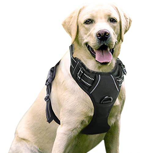
This is the pack is the one my dog is wearing in that picture. It gets the job done. Only minor complaints are the lack of a d-ring (I either use a separate front clip harness underneath or clip the leash to the handle on the back). And a tendency to shift to the side while walking.
Ruff wear packs are really well reviewed, but come at a much higher cost, which is why I don't have one hah.
As for bug spray, I'm still experimenting. There is a repel lemon eucalyptus spay that was recommended to me, or a Picaridin/Icaridin based spray like Bug Guard or Sawyer which is supposed to work well.
In that first pic she is wearing an Insect Shield bandanna, specific for dogs. It worked pretty well for mosquitoes, but did dick-all at keeping biting flies away. She got a nice bite near hear eye that caused some swelling.