
What are
/r/CyclePDX's
favorite Products & Services?
From 3.5 billion Reddit comments
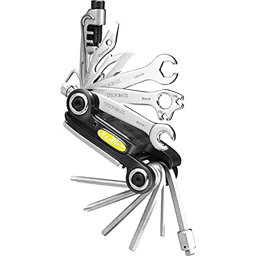
The most popular Products mentioned in /r/CyclePDX:


The most popular Services mentioned in /r/CyclePDX:
Ride With GPS
Strava
SurveyMonkey
MapMyRIDE
OfferUp
The most popular Android Apps mentioned in /r/CyclePDX:

Maps & GPS Navigation — OsmAnd

MyRadar Weather Radar
The most popular reviews in /r/CyclePDX:
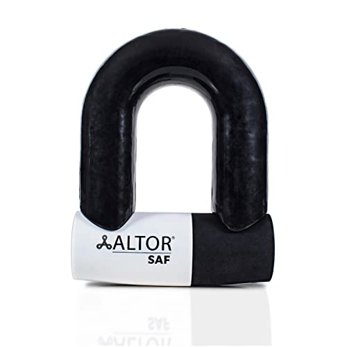
Pretty much any standard lock will be able to be defeated with an angle grinder extremely quickly. This includes u-locks and the popular abus bordo folding style as well.
There are a couple of fairly impractical options that exceed these though. The first is the Kryptonite New York Fahgettaboudit, which is a super heavy duty chain lock. The chains are very thick hardened steel, designed to be difficult to cut through. That doesn’t mean it’s impossible though, as there are many reports of thieves with moderately decent angle grinders cutting through them very quickly.
The only one that’s really angle grinder safe is the Altor SAF. It’s expensive though, and almost comically large at 13+ pounds. Probably something that only makes sense if you leave it locked to your most common destination. It’s thick enough that it cannot be cut through with a standard angle grinder though, and is probably the only lock that really qualifies as safe from that type of attack.
If a thief can’t cut through a lock though, they will cut through whatever your bike is locked to or a part of the bike itself. The realistic solution is to just get appropriate insurance and a reasonable lock used in combo with a good locking strategy that will make your bike less attractive to thieves. I use the kryptonite evolution that comes in a combo with a cable that I connect to the front wheel.
I've done the route listed in blue here that goes through Vernonia and it was quite nice. 100% paved, very little traffic, and you get 22 miles on the Banks Vernonia trail through the woods.
I'd recommend taking the MAX out to the last stop on the blue line in Hillsboro (Hatfield Government Center) and this is my suggested route from there to Banks.
I am off the bike for a bit due to a back injury but that sounds pretty compatible with my riding style. My favorite thing is to get long-ish commute rides in the mornings before work, like this
https://www.strava.com/activities/333460232
and hope to be back into it soon. good luck, i found the best thing is to go to different group rides and talk to people. bring cards with your online contact info so you can meet up with ones you get along with.
Marine Drive from Blue Lake to Troutdale is pretty incredible. The Willamette River loop is excellent as well. For gravel, you can't beat the Crow-Zellerbach Trail.
There’s a lot of road involved to get there and back, but Otto Miller is an option. You could also head out to Pumpkin Ridge. Not exactly 2000+ ft for a single gravel climb but better than Saltzman. Also if you haven’t ridden the CZ Trail from Scappoose to Vernonia I recommend it! Gets real muddy on the west side of the pass over the winter, but it’s a great route.
The route we’ve taken a number of times out to the Mt Hood area (just repeated this last weekend and it was still awesome) is this: https://ridewithgps.com/trips/16119676.
Low traffic for much of it and beautiful. Once you hit Lolo pass it’s only a few miles to Welches (would connect you to 26) or you can continue the route and head out into the backwoods on FR 1810 (original Ride With GPS route followed a private road with crazy huge gravel- after the intersection with the PCT you just hang a right instead of going forward).
I lean on weather radar apps moreso than the per-hour predictions that many apps offer. It'll let you judge if you're able to beat the worst of it by hustling, or if you're going to get soaked no matter what.
Also, if I wear anything too waterproof/non-breathable, I turn into a big sweaty mess which negates the whole point. So I tend to lean more on quick-drying fabrics that have some DWR rather than full-on rain paints, and a Marmot Precip for the jacket.
Full disclosure I work at Ride with GPS. Opening the mobile app and referencing the heatmap, looks like a fair amount of people are riding the following which cuts out some of the highway riding https://ridewithgps.com/routes/36466509
If you're climbing in the city proper, Saltzman road in Forest Park is one of the highest climbs in the city and is free of cars:
https://www.strava.com/segments/3468870
For higher climbs you'll need to look outside of the city as /u/Leland_Stamper suggested.
The Bridge of the Dirt Gods can be a fun S24O route. It's 104 miles round trip with camping at 40 miles into the route. If you would like you can reverse the route (out historic 30 and then climb that gravel!). I actually prefer it this way so that you can have a solid day with some off road and then come back hard on the tarmac. Keep in mind that it is an OMTM ride so there is a little single track section near Camas (not too gnarly though).
https://ridewithgps.com/routes/35225382 I have really enjoyed this route for a after work ride. Can easily add in Tabor if you want. Some stop lights and stop signs but as far as city riding goes, its a lot of riding without stopping.
Around Happy Valley, I'd string together segments from La Doyenne.
You didn't ask about Clark County, but Washougal River Road is a pretty ride, but you have to time it to avoid traffic from rush hour and hot sunny days when people go to recreate there. The river is the show, go on a nice spring day when it's running.
The rest of my suggestions are under your nose.
Columbia River Highway (HCRH):
Larch Mountain (LMR), and if you don't want to go all 15 miles to the top you can branch onto Deverell. It's good pavement and I don't think I've ever seen another soul on that road.
Hurlburt is a good diversion that takes you to Littlepage, where other neat roads appear.
Knieriem (I hardly know him! *rimshot*) is a very quiet paved valley road that connects back to HCRH just befor LMR.
Louden/Loudon (depending on the sign) is a challenge that goes up to LMR. I turn off on Deverell when going up because there was a territorial unleashed dog just past that intersection some years ago, and was reminded of just the other week… fortunately on the way down.
Skyline Area:
You've never done Logie Trail or Rocky Point? LTR is mostly dense forest and a little ragged in places so it's better for climbing. RPR is logged to hell, so the views are great and most people driving on it are there for the mountain bike trails.
Near CPR, Rock Creek Road is a quiet, beautiful segment. There's a tiny valley with small farms and goats. Just beware of the short stretch of craters just off Old CPR.
There are lots of nice roads north of 26 TBH. Get lost out there.
I did the HR to rowena crest last week, but I extended the route into a 60-mile figure-8 that went through The Dalles: Rowena Ridgerunner
People ride Larch Mountain a lot, it's a huge climb and nearby to Portland. You can ride there from town, or head out from Troutdale. You could also check out crown point while you're out that way, but that's also a fun destination from Portland.
This is a good collection of rides West of Portland. Feel free to DM me, I ride regularly with this club and can also recommend a few other routes.
https://ridewithgps.com/ambassadors/19-portland-velo-cycling-club
As others will point out it requires a lot of engineering. They do make all kinds of disc brake adapters for old bikes now. Of course they are sketchy af...
With limited time I'd definitely just do something from town, we have amazing riding close by so no sense wasting time in the car, and starting from NW Portland is nice for easy access to coffee/beer/snacks before or after. I would pass on anything that doesn't get you some good climbing, since you sound up for it.
I would recommend hitting some of the classic roads and climbs of Portland cycling. Something like this would serve you really well IMO: https://ridewithgps.com/routes/36077705
Saltzman (dirt), Old Germantown, Leif Erikson Dr (dirt), Washington Park and Council Crest are all mainstays and you'd have minimal time with unpleasant traffic. We're super lucky to have the road riding we've got here, and you can hit a lot of it in 50 miles from downtown. You could also consider NW 53rd Dr & NW Thompson from NW Cornell to NW Skyline, NW Newberry Rd, Council Crest via NW Montgomery, Riverview Cemetery, NW Rock Creek Rd. When you come back again and have more time, there's more to do in town and tons of great roads within a couple hours drive or ride.
Example 1: from downtown https://ridewithgps.com/routes/30136296
Cruising down Broadway drive is lovely, you're far faster than cars. I recommend a 30s gap at the Benson Bubbler.
https://ridewithgps.com/routes/30136307
Option 2, west side. Use it as an extra climb if you're hitting the cemetery route into SE. Glad to see you made it up there, it's one of the finest views in the city!
Here's Sunday's ride: Hood River to The Dalles Loop
​
I followed another person's route and modified in a few places with a start near the Hood River Event Site, skipped gravel road shortcuts, and added a McDonalds stop in The Dalles for water bottle refills (they were super nice about me refilling without buying anything).
​
Do you mind checking your link? The link takes me to a map of Dufur, I love the Dufur area and would like to do your ride when I get a chance. I did the Sherar's Falls Scenic Bikeway in Maupin last year and it's a really nice ride in the area.
Would you mind linking?
Here is one of my "secret" routes in the area too!
Dufur is an awesome place with access to some great cycling. There is more to explore than what I have highlighted, but that climb and descent up Dufur Valley Road is a ton of fun. Generally, when I go out there, I only see like 5-10 other cars the entire time I'm there. Also, if I am not mistaken, the road is still closed at a certain point and doesn't connect to 35 making through traffic a complete non issue.
There's really nothing further south for a while. You can wind your way out of Rickreal and eventually hook up with 410 to Newport, or if you want an all-nice-tarmac experience, 34 is a great road without too much traffic.
Edit: There's also the non-Trask section of this one: https://ridewithgps.com/routes/6970396
These are super awesome for the price. They can even be used with prescription lenses and have an really nice zippable case!
KAPVOE Photochromic Cycling... https://www.amazon.com/dp/B08ZJGDYSH?ref=ppx_pop_mob_ap_share
I second the SW hills and Council Crest and Washington Parkt. It is a beautiful area, low traffic and great roads. You can Circle Council Crest as many times as you need. If I'm coming from Terwilliger I normally go up SW Westwood drive, the streets are not great but there really any traffic.
Also loops around Lake Oswego to West Lynn to Oregon City and up the East side of the rive is awesome. This is from the NW but you can easily adapt it. https://ridewithgps.com/routes/33704028
Terwilliger is great riding once you get past George Himes Park. Or swing a left from the park and explore the roads between Marquam Nature Park and Sunset Ave. Good hilly terrain. Check out the PDX Classics routes for ideas.
You could also drop down through the cemetery, cross 43 at the light, and right the Willamette River loop.
There are countless great roads in the SW hills with minimal traffic. Get to Council Crest via Fairmount, then ride Hewitt to the Zoo/Washington Park. Then either reverse it, or ride back up Vista/Montgomery to Council Crest.
The Ronde PDX route for last year hits a lot of the more popular climbs in the SW hills. Would be a good starting place.
Dig a bit deeper and you'll find a lot more. Also try making some routes using RidewithGPS or Strava if you haven't yet.
I'd look at a strava heatmap (or RideWithGPS) heatmap of the area. This will show where people ride the most, and while not fool-proof, is a presumptively reliable indicator of a road's quality.
I'm sure someone will chime and mention the Giro d'PDX which is a collection of steep climbs down in SW Portland and LO. the route is on RidewithGPS here:
https://ridewithgps.com/ambassador_routes/968-giro-pdx-le-foglie-morte-di-sud-portland
Lucky for you, there are a ton of cool climbs, paths, little parks, and niches to explore down there. Since you have a mountain bike you'll be in a great position to explore them!
I'd say you just have to see it for your self and decide if it's in your comfort zone. Although there is no shoulder for most of those roads back there I find the cars to be patience and pass with care. Nobody goes out there to get somewhere fast, they would take 84 otherwise. I've ridden that road the the surrounding roads many times and I usually feel safer there than in the city. There are several roads that parallel the main historic highway and they have even less traffic. Check this other century route I did over the summer because it incorporates some of those lines. This route is essentially Larch Mountain + Bull run so it's a bit heavy on the climbing. https://ridewithgps.com/trips/72434865
You could actually do this route on a road bike, the way I went up was 100% paved. Essentially I rode the MAX out to Hillsboro and the road to Banks and after that you can take the Banks-Vernonia trail to Stub Stewart Park.
Here is the ride with GPS track if you even want to try it: https://ridewithgps.com/trips/66944540
If you do this route, I'd strongly suggest taking a quick detour on Shipley Rd at mile 29 for one of the most pleasant little climbs around. Just rejoin the route with a similarly grin-inducing descent on Marmot. In fact, you could use the OMTM route from their ride of the month series, which has a number of excellent little niceties added: https://ridewithgps.com/routes/35089220
You'd have to go pretty far (both distance and elevation) to go through the Gifford. Then youd still have to figure out how to cross in either Hood River or Cascade Locks. Something like this: https://ridewithgps.com/routes/26388314
https://ridewithgps.com/routes/34733967
I’ve done this route twice now. Last Sunday it was a bit snowy but doable, if they have gotten more snow since then I’m not sure if I would do it until it gets warmer. Starts on CZ, then peels off onto a logging road. Lots of fun
off the top of my head:
- Larch Mountain
- Vista Point
- Mt Scott
- West Hills (Skyline)
- Council Crest
- Lake Oswego
If you go on ridewithgps.com and type any of those in, something should come up. If you really want to go hard, try this
Best is subjective— I’d look up some of the Seattle international Randonneurs routes.
https://ridewithgps.com/organizations/29-seattle-international-randonneurs/routes?name=Portland
The shortest distance of course will track I5, but there are some fantastic routes both further out by the coast and East of the cascades if you want to make it more of an adventure! At the expense of bonus miles of course.
Lots of flat empty roads towards kelly point park and around far north Portland.
Also if you drive far enough west towards like North Plains or Helvetia there's lots of much more scenic flats, and you could always like climb up dorland or something and then turn around.
Riding a loop around Milwaulkie/Oregon City/West Linn/Lake Oswego is a nice moderate ride. Use springwater/trolley trail/river road in lake oswego/terwilliger (or the cemetary/springwater) back to town. Nice 30ish mile ride with no major climbing.
Pittock Mansion isn't all the way up the hill, and could be a nice out-and-back destination up the quiet neighborhood streets.
Endless Summer Saturday Ride is a really nice moderate route that is a staple of my cycling team.
Here's a route on MapMyRide that might get you started. I suspect you can pretty much go in the reverse direction.
http://www.mapmyride.com/routes/view/embedded/71943052
Also, I believe it's legal to ride a bike on HWY 26 between the zoo exit and the Jefferson exit. Though I'm not sure I'd want to.
https://ridewithgps.com/routes/27965053
This is kinda THE go to all road route out of Portland Proper. All the gravel that's worth riding without getting waaay out there and uses the most popular roadie options to get there and back. Further west you head from the furthest point out is almost all gravel if you want more.
Here is the West side route that I mentioned. Saltzman is closed to autos once it hits Forest Park, and the access from Hwy 30 during the week is closed for the next 3 months. It sounds like you can still access it via Leif Erickson, but that's a much rougher surface i.e. embedded large-ish gravel vs. small groomed gravel. I'd ride either on 28's.
The Ronde route is shorter than I remember, but the ridewithgps elevation is an underestimate because the route has so much rapid up-and-down.
Oh and BikeFlights is good for traveling anywhere with your bike, not just PDX. Bill just happens to live in town so we count it as a local-ish business.
Thank you to all the respondents that have already participated. I have created a new, more open-ended questionnaire if you would like to share your comments. Take this new survey here
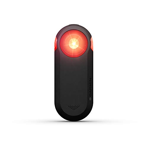
Check it out - this might be what you're looking for. You hook it up to a display on your bike, and the display tells you if there are cars behind you, how many cars, and relative speed to you. It's extremely helpful in my commute, and I've heard this echoed many times.
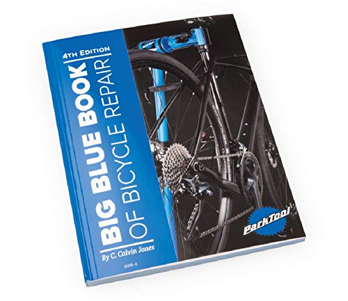
Only $30 brand new for the Big Blue Book of Bicycle Repair
hah, it could have been a lot worse -- traffic was heavy (moving slower than me -- I was in a bike lane), and they didn't signal so their rear bumper clipped my front wheel, so I went over the bike and landed hard.
The folks in the car were flustered, but did pull over and were easy to deal with. Having video made it *really* easy to work with their insurance company.
All that said: I'm a lot more cautious about passing on the right, now, and I never split lanes.
I'd suggest sticking with red/white for lights, and having one fixed to the bars or the front of your helmet, so it's clear from the lights wether you're getting closer or moving away, and those colors signal "vehicle" more than blue / green.
I carry extra little front/rear lights to hand out -- happy to meet up and give you a set if you want. (I order ~$20 worth of these, or whatever's cheap on amazon each year. They take a couple weeks to arrive, but they're usually just fine lights, and they're damned cheap: https://smile.amazon.com/Malker-Bicycle-Light-Front-Silicone/dp/B01L773R9A/ref=sxin_3_ac_d_pm?ac_md=1-0-VW5kZXIgJDEw-ac_d_pm&crid=3CBAT4LF2P2PB&keywords=bike+lights&pd_rd_i=B01L773R9A&pd_rd_r=5fb93a63-e711-4247-af9d-aa8e2baf051d&pd_rd_w=2N2Ws&pd_rd_wg=YZdsO&pf_rd_p=aba5dc0d-7593-4752-a14d-357ecc5c98cc&pf_rd_r=CVC5CK1023PNW1N7ZW19&psc=1&qid=1576278523&sprefix=cell+phone+game%2Caps%2C202 )
Peal Izumi gel gloves have always worked well for me. Comfortable. Good price point. They last a good long time for thirty five bucks.
I've never had good luck with rain pants, so Ima check out the recommendation from /u/Ozensha.
Edit to say, it was not clear from your post if you're looking for good rain gloves. I read it as good gloves and also good rain gear (separate items). Sorry if my recommendation is not helpful as you were actually looking for rain gloves.