
What are
/r/NYCbike's
favorite Products & Services?
From 3.5 billion Reddit comments
The most popular Products mentioned in /r/NYCbike:


The most popular Services mentioned in /r/NYCbike:
Ride With GPS
Strava
Komoot
MapMyRIDE
Google Maps
Bikemap
OfferUp
Groupon
Facebook Marketplace
OpenStreetMap
Bing Maps
AllTrails
Garmin Connect
Bypass Paywalls
ConsumerReports.org
The most popular Android Apps mentioned in /r/NYCbike:

The most popular reviews in /r/NYCbike:
One of my favorites is take Metro North to Brewster NY. Then it is a short ride to the beginning of the Putnan County trailway. That connects with the North Westchester Trailway, then South Westchester Trailway, then Van Cortland Park in the Bronx. Then it is a short ride via the streets of Kingsbridge and Marble Hill, and you're in Manhattan. 60 or so miles, nearly all of it on rail trails.
Another one of my favorites when I need to get back into shape, is to take the train to Croton, and do my hill-repeats ride.
A couple of ideas:
A one-way ride to Montauk / the Hamptons with a return on LIRR. A good day trip if you start early or of course can make it a weekend. I suggest a route via the north fork and Shelter Island to Montauk. There are plenty of organized rides and ridewithgps links. Here is the one-day route I took in early November last year, which doubles back to Southampton because westbound LIRR trains weren't running from Montauk at the time: https://ridewithgps.com/trips/41860383
Take Metro North to Poughkeepsie and do a round trip route northeast into western Mass or across the river to the Ashokan Reservoir and Big Indian Wilderness.
Poughkeepsie's post office is on the National Register of Historic Places, so pop in as you pass by. Mountain Brauhaus is a few miles downhill from New Paltz and a pretty popular restaurant for German food - I recommend you call ahead if you want to try it.
I've done Poughkeepsie -> New Paltz and it was pretty easy. There was one section of the trail that was closed for maintenance over the summer, but the detour was not bad and there isn't a lot of traffic on the roads in that area.
If you are in New Paltz, you are SO CLOSE to Minnewaska State Preserve. It's probably another day of riding to do a loop through (~50 miles total if you connect it with New Paltz -> Poughkeepsie), but it is spectacular. It's a long climb on gravel carriage roads (I did it on a road bike) and you get some amazing views at the top. If not this trip, then make another trip for it.
Can't recommend it enough! Did this very ride a few months back and would do it again. I basically looked at google maps suggestions, printed it out, compared it to the strava heat map, and scratched off all the nonsense Google suggested.
Only two of us today, but the ride went well! The weather cleared up and it turned out to be a really nice day for the ride.
My suggestions:
Last Summer Hurrah: Grand Army Plaza -> Eastern Parkway -> Rockaway Parkway -> 94th -> Shore Parkway bike path to Nathan's Hotdogs on Coney -> Ocean Parkway -> Prospect Park back to Grand Army Plaza
DUMBO to Corona: Meet at Manhattan Bridge base in DUMBO -> Flushing Ave -> Adelphi -> Willoughby -> Central Ave -> Around the bottom of Evergreen Cemetary -> Through Highland Park to Cooper Ave -> Myrtle to Forest Park -> Up into Corona Park -> Maybe 7 train home
River Road is your best bet as JRinNYC notes, but if that's a little much for right now, the Manhattan and WB bridges are also nice hills. Just promise us you won't try repeats on them during peak commuting hours. My two favorite climbs in the city proper are on the west side. (1) from the Hudson River Path under the GWB all the way over the pedestrian bridge and up to Fort Washington aka "The Great Wall Climb" https://www.strava.com/segments/2245425 and (2) this little guy from St. Clair to Grant's Tomb https://www.strava.com/segments/9729207
I shoot out by Tavern on the Green, 67th St. take left/right on Columbus to get to 66th, then take it all the way west to Riverside Blvd and get back on the Greenway at 59th. Really easy and pretty stress free. https://ridewithgps.com/trips/69396040
With the mess yesterday and the overnight deep freeze, you knew we'd wake up to this! Days like this are made for citibikes! https://www.strava.com/activities/249848170
Heavy bikes, low center of gravity, easy to steer and get feet down, no worries about salt messing up your stuff, wide tires and easy gearing. The bike was frozen in "3rd gear", but whatever. It was a hoot commuting in this morning!
Highly recommend a membership for days you can't do a round trip or for really nasty roads like this. Just make sure to carry a key food bag or two to cover the seat (that ice will melt on your pants otherwise).
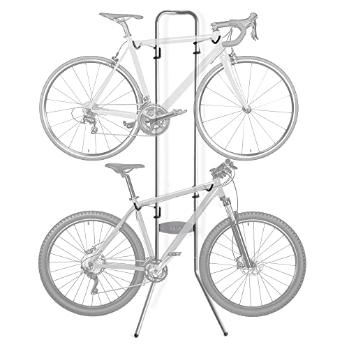
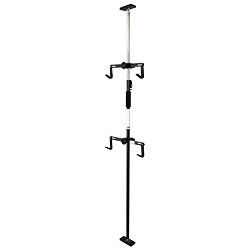
I feel your pain. If I were in your shoes I’d sure as hell want to bring my bike into my apartment too.
I’ve got two bikes I switch between regularly, and recently got this from Amazon. It’s right against the wall just inside my apartment, so I can hang them up and take them down easily just as I’m coming and going.
Don’t worry about hanging your bike by the rim of a wheel. Unless your frame is made out of ultra dense material from a collapsed star and weighs a ton you’ll be fine. I wouldn’t discount a pulley system with the ceiling, even if it’s tall either. Installation would certainly be a pain, but worth it once you got it done. I’ve seen some innovative setups on YouTube, you can look there for some inspiration and brainstorming. It’s also possible you could make something just to fit your needs in a DIY project. Before I bought my rack I was contemplating following some instructions online to make one myself out of $50 or so of PVC pipe or wood from a hardware store. Good luck with whatever you choose.
your plan is good, but just to throw it out there, another option is to keep heading north: take the west side greenway to its end at Dyckman, north along Broadway over the bridge and to Van Cortlandt park, through the park (some of it is unpaved, watch out), and then along the South County Trailway basically until you get tired and you can take Metro-North back home. Depending on exactly where you start, it's just over 50 km from lower Manhattan to Tarrytown, for example, and you can get lunch there before heading home if you want.
There's lots of nice riding in the Bronx. Unfortunately, the first half of your route isn't any of it. Southern Blvd isn't horrible, but I think this is nicer. The last few blocks around Whitlock and getting across the river are going to suck no matter what you do.
I've experimented with cutting over to the Hunts Point side of the expressway at Leggett and going up Garrison or Lafayette to Edgewater. Or 149th to Oak Point Ave and wind your way through that way. I can't really recommend either of those. Sometimes I take the Bruckner service road from 141st to 149th, but I really don't recommend that if you're not comfortable riding in traffic.
Once you do get over the Bronx River, you're home free. You could go down Story Ave to Soundview Ave (don't even think of taking Bruckner Blvd). That's not bad, but way better is to get into the park and take the bike path all the way down to Harding Park, That's a weird little private community with funky twisty streets, but the route I mapped is easy to follow and low traffic.
The last little bit is the Shore Haven Bikepath. The entrance off Bronx River Ave is a little hard to find, but it is a pretty route. It' some kind of crushed gravel, but in really good shape and should be fine unless you're on skinny road bike tires. If that worries you, go across Gildersleeve and take Soundview from there.
Discovering 9W is almost a life changing event for NYC cyclist. As it's your first time, a few notes.
Not sure where you're coming from, but if coming up the West Side Bike Path, take the the 181st St pedestrian bridge to get to the GWB. I take a right on Cabrini to cut that climb in half.
The narrow hairpin on the entrance ramp to GWB will be the worst of it. Take a right immediately after the bridge, this is actually Hudson Terrace, (not 9W). About 2 miles up, you'll hit a T, take a left and then on right on to 9W (or Sylvan as it's known locally). There's no shoulder here yet, but don't worry. The only uphill of note is CNBC, which is just about like Harlem hill in CP. After you crest CNBC Hill, at mile marker 4, you get to the nice, broad shoulder.
You can take 9W as far as you want (I just took it up to Beacon/Newburgh last week). Starting at Mile Maker 10, you're going to hit 2+ miles of serious downhill. Stop at The Market if you need to refresh, or turn around.
I've been biking this for years and have lots of routes. Fyi, here's a loop I did yesterday around the Tappan Zee with another first time friend: https://ridewithgps.com/trips/75137847
I love this ride! As a newbie to the area this is one of my fave for a half day trip. Here's my Ride With GPS route. It's not perfect but it's something to go odd https://ridewithgps.com/trips/67055525
A few of my friends and I are working on organizing monthly rides. Our next ride is this Saturday night 9/26. We'll be handing out neon glowsticks and riding about 17 miles through Greenpoint, Williamsburg, Downtown, and Redhook.
https://www.strava.com/clubs/155049/group_events/71837?new=true
Where are you located? The greenway in Manhattan running from Fort Tryon on the West Side down under the bottom of the island to 34th on the East Side is great, but unless you live right on the route it's tough to get to without biking on roads. You could also ride around the shores of Randall's Island and Roosevelt Island.
Also, I recommend bone conduction headphones like these ones, which I use to listen to music/podcasts while I bike on the street while still being able to hear traffic around me.
Agree with everything you said. However, if OP wants to avoid 9W as much as possible, let me make the following suggestion.
Take Joseph Clark Trail to the end to Oak Tree Rd, and instead of taking it out to 9W, take a right on Piermont Road (State Hwy 340) to Dean St in Tenafly, then out to E Palisades Ave.
See route from ~mile 60 on: https://ridewithgps.com/trips/57897906
I have this one saved for my next free day! Recently did this one from NYCC taking the train to Golden's Bridge and back. The middle part through Mountain Lake park was challenging . There was a section that I had to skip because the farm it seemed to cut through had their gates closed (it was a Sunday). I think it was the northeastern most loop on the link.
Look on the East Coast Greenway site, they recently changed there NYC approach/departure.
Here is my route to Philly, using the Staten Island Ferry and the ECG route. It passes Princeton. I have not ridden this yet. https://ridewithgps.com/routes/37042131
> Step 1 is always wearing a camera, if you can afford one.
If you can afford the bike, helmet, lights, bell, etc you can afford the camera. I picked up two dash cams for ~$24 each from China . Here is the exact same cam on Groupon for $19.99. Despite the negative reviews it does the job well. Whoever wrote the description didn't read the manual. It does not have a battery. It has a supercap that holds enough power to deal with interruptions when the car starts. It needs to be plugged into an external power source. I run mine for hours off of an external cell phone battery. The UI is clunky, but the video quality is quite good.
IMO it's already paid for itself. About a week after I installed it I had a driver make a left in front of me and I barely cleared being run over. The side of her car clipped my rear wheel and knocked me off balance. Without the video I would have never been able to even report the incident.
I recently switched from a CitiBike to a Van Moof Smart S. It's nice to ride the same bike every day and not deal with inconsistencies between Citi bikes.
It is easier to ride faster (I usually go 16 - 20 mph when conditions allow) and whereas a CitiBike is tolerable to ride, my VanMoof is simply a pleasure.
I spend a good deal of my commute at traffic lights or dealing with traffic, so I don't notice a huge time savings. It's just nice to have a bike I enjoy riding.
This is a pretty much full on greenway route that I took: https://www.strava.com/activities/370700996 all you need to do is get from LIC in to Williamsburg which is obviously very easy over the poulaski.
If you're an experienced road cyclist, definitely Bedford. If you're a not-so-confident rider with a mountain bike or hybrid, give Ocean Parkway a go. But don't go fast on Ocean Parkway--I ended up in the hospital that way one time because the pavement had a giant bump in it (yes, in the bike lane). Besides, as others pointed out, the multitude of roads on OP is confusing, better to stick with something simple.
I went around there a few times from Manhattan; this is sort of the final/best version of my route: http://connect.garmin.com/activity/119234674 .
Speaking of Bicycle Pro, I ran out of water yesterday (two big bottles worth) riding home from the city on a day when it hit 99F. I was not far from the shop so I figured I'd just press on and ask them to refill my water bottles. I was astounded when they wouldn't. They claimed they didn't have any water. Really? There's not even a sink in the bathroom they could have filled my bottle from?
A pizza place a little further along was more accommodating with a refill.
I'm thinking about doing the same soon. I pulled this route from an old thread in this sub: https://ridewithgps.com/trips/10117
Edit: here's the thread: https://www.reddit.com/r/NYCbike/comments/26alvh/fun_paths_to_montauk/
Yup, here it is via Komoot: https://www.komoot.com/tour/514396847?ref=wtd (I trimmed off the start and end points a bit, so the mileage might be slightly different)
What do you mean? You can get on & off on the west side of the street, where Jackson meets 49th.
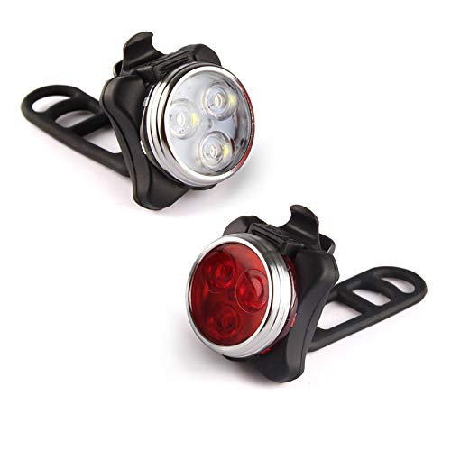
These little guys attach to anything in seconds, offer good battery life, are reasonably bright but not obnoxious, and are easy to recharge — I’ve bought three pairs for various bikes and always been pretty happy with them. Plus, they’re pretty damn cheap.
https://www.amazon.com/Ascher-Rechargeable-Headlight-Resistant-Included/dp/B01EUQ7ZQG/
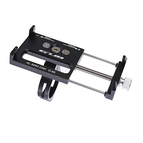
quad lock is nice, but requires the use of their case.
i use this mount - it's cheap but solid and holds well. it will work with whatever phone case you use now. if you choose this, make sure to look at the other variants; some are taller and keep the phone higher off the handlebar, some have side grip points, some have bottom and side grip points. don't pay more than $13-$18 from whatever seller has the one you want.
I also live in a small apt in NYC and I use this - Amazon Link
Photo of it on my wall - Photo
Lots of other good ideas here, but I'll add that you can download the Reported app and report unsafe driving, such as blocking the bike lanes. Focus on taxis and other vehicles with TLC on the plates, because they are the only kind that will get punished.
I beg to differ, this is where things are the diciest, although the obstacles are pedestrians and other cyclists. Perhaps three feet for bidirectional foot/bike traffic squashed between the FDR and a building next to the sewage outflow.
BTDT. https://ridewithgps.com/trips/18856055 slavishly follows the ECG. Yup, the parts through downtown New Rochelle and Portchester are sub-optimal, but they're only a few blocks each.
The only part of the ECG route that I just don't understand is why they put you on Playland Parkway through Rye. I strongly recommend you take Osborn Rd / Oakland Beach Ave about 1/2 mile to the south of the parkway.
You can try going from the Brooklyn Bridge to the Hudson River Greenway along Manhattan(Flat roads but crowded). Then cross over the George Washington Bridge and following along 9W(Hilly with some slightly more challenging climbs) to Tallman Mountain State Park. Then find somewhere to stay around there. Depending on which part of Brooklyn you start from it may be 25-35 mile one way. https://www.strava.com/routes/3358211
Hey /u/heavypedal917 Just finished my rides in Woodstock. Would have to say 2 of the best rides I've ever done.
Ashokan Res: https://ridewithgps.com/trips/67956566
Slide Mountain: https://ridewithgps.com/trips/68025811
Swapped in a ride around Ashokan Res instead of hitting Saugerties/Kingston, absolutely terrific. Nothing like 600' of climbing in the first 4 miles to get your heart going.
On the other, I can say that that last climb up Slide Mt was the hardest 1.5 miles I've ever ridden. Looks to be an average of 9.6%. Was the only time in my time cycling where I thought about walking, though I did make it. Couple other challenge were due to repaving. On that steep climb in Denning they had stripped the road down to dirt, and because of the storms last night, there was a bit of mud, and my 700x28s were either slipping or digging in. And, on the steepest decline after Peekamouse, due to repaving, it was a couple of miles of loose gravel, like riding a jackhammer trying to keep in under 15 mph. And yup, took Ridge Rd, cuz who doesn't need a few more 10% climbs at the end of a 90 mile ride. ;0. Thanks again for the info.
/u/vin_espo I'd definitely check out the ride around Ashokan above.
/u/brash_name /u/ontherok I did indeed do this route this morning. https://ridewithgps.com/trips/67042717
Think it's a good route until they fix the SCT. Went down Rt9 to Hastings then cut over to SCT. The first little bit in Tarrytown was the worst of it. A bit of rolling hills on Rt9 but elevation is still about half as it is on the west side of the Hudson. The Welcome Center on the Tarrytown side of TZB is a good halfway point to refill water bottles, snack and hit the restrooms.
/u/ontherok, I'm on a road bike w/ 700/28c, not sure what you're riding. Up to you if you want to take it slow and take SCT the whole way down. But Rt9 is pretty broad, no issue w/ traffic this morning.
technically it's a little farther but it's far faster/safer to take westside highway, imo: https://ridewithgps.com/routes/35989885
folks will have Opinions on the lil' ramp underneath the GWB but 2" of climbing is better than the alternative, for this route at least.
I believe the point being made was that if you want to ride from, say, Country Club to Whitestone, you would have to do something absurd like this, which does go through the South Bronx.
The NYC Century was one of the easiest rides around, and relied on having a safe route since they never did road closures for it. Here's 2019 and I think this one is 2017 (No Pelham Bay). It stays completely in NYC city limits though, not sure if that's what you want.
Note that the East Coast Greenway route *IS* the D&R path, from New Brunswick to Trenton.
Here's what I like best nowadays, route starting from Rahway or Woodbridge NJT.
No shit dude I left at like 750 from bushwick! We definitely crossed paths at some point. How'd you like river road? Also try gypsy donut next time for some quality carbs.
Edit: strava = https://www.strava.com/activities/156311461
Here's one you could do. Starts and ends in lower Manhattan. Start early before the Brooklyn Bridge gets way crowded; otherwise you will hate humanity (and your girlfriend will hate you).
It would be helpful to know where your starting point is since if, e.g., you're uptown, in Queens, etc., that changes the equation.
You'll have to adjust your route. After the Bayside Marina the Cross Island/Joe Michaels mile is being repaired. https://www.strava.com/activities/1682941185
This is a ride I did a few days ago. You'll see I exited the Marina and took 216th st, you can also take 215th PL. A few quiet streets and you can get to Northern Blvd where the rest of your route picks up.
You can use this route (I've changed it a few times, but this one starts from Joe Michaels mile) and head to douglaston & Great Neck. A few options to get the LIRR along the route as well. https://ridewithgps.com/users/1089525/routes
Better than expected. Here's a few photos and the trip log in RideWithGPS.
We packed a picnic lunch and made an adventure of it. Rode to the Lafayette Ave stop on the Q50 (last stop before the bridge) and got the bus to 20th Ave (the first stop on the other side), then rode over to Fort Totten Park. That's a nice part of Queens to ride through. Mostly quiet residential streets. Ditto for the part through the Country Club section of The Bronx. I'd never been to Fort Totten before; it's beautiful.
Anyway, the racks work well. They're easy to use. They're even easier once you figure out that you need to obey the clearly visible signs that tell you which side to put your front wheel on :-) They're the kind with a swing arm that come up over your front tire. As such, they work better on bikes without fenders. I've got fenders on my bike, but it still worked OK. The bikes seemed pretty secure.
Both bus drivers were very friendly, and both of them said we were not their first passengers to use the racks. So, good to know they're getting used.
The down side is the Q50 only runs every half hour (at least on Saturday). The other bus over the bridge, the Q44, is much more frequent, but has no bike racks. Maybe some day? And, of course, this being NYC, the bus schedule is only a vague suggestion. In both directions, the bus was about 15 minutes behind schedule.
But, basically, a big win. I was able to get from The Bronx to Queens by bike. Today was a good day.
Here's my rec: the greenway is fine if you're close to it. Otherwise, I'm happy doing Columbus/9th Ave to 40th to avoid Times Square, cross over to Broadway, which at this point is sandwiched between pedestrian plazas so not much traffic, then from Union Sq, I go east on 16th St to 2nd Ave and take that all the way down to the Manhattan Bridge entrance by Canal. From Manhattan Bridge, I take Jay St and take a left on Schermehorn, right onto Hoyt and then left on Dean and take Dean all the way until you get to your Crown Heights area.
https://www.openstreetmap.org/#map=16/41.0559/-73.8196
Google maps is so far behind the times. But openstreetmap gets updated as soon as someone notices the change and makes an update. Also check out the cycle map feature.
this, but instead of Route 119, get back on the South County Trailway in Elmsford for a little bit, and take the Tarrytown Lakes Extension into Tarrytown.
For lights I use these cheap little bastards: https://www.amazon.com/Ascher-Rechargeable-Headlight-Resistant-Included/dp/B01EUQ7ZQG/ref=mp_s_a_1_3?dchild=1&keywords=bike+lights&qid=1627013859&sprefix=bike+li&sr=8-3
Easy on and off but stay on the bike even through rough terrain, cheap as hell, bright enough all things considered, rechargeable with a usb, and their battery life is bizarrely long — like, I can’t remember when I last charged them and I use them every day.
+1 on the safety glasses.
If you wanna spend a little more and look like a mamil dbag, these glasses are a good buy. Comes with 3 interchangeable lenses, including a clear lens. Block the wind real nice.
Once it gets a little colder the ski goggles are coming out.
Good comments here.
- I commute from BedStuy to East Harlem daily. I'm super happy I've started to do it. I actually get to see the city each day. Can't wait until summer when I can enjoy it a bit more.
- Spend a lot on gloves, but your fingers well get numb. Make sure your core is warm, I find this alleviates numb fingers and toes. Balaclavas are also dope, since when some ~~arsehole~~ pedestrian realises they're in the bike lane, balaclavas scare them out a little.
- It's like not safe, but safe. There are dickheads everywhere, particularly in midtown. Keep aware & you'll get the hang of it.
- If you can get away with not using a backpack, it will make getting to work a lot less sweatier.
- I ride a track bike and can't fit racks to my frame. So I use one of these to my saddle. It's no good for a laptop, but amazing for clothes, food, etc. I got it heaps cheaper than amazon at 718 bikes in BK.
Though any bike/setup is suitable. Ultimately just do it, and you'll make it stick.
Buy this book - Zinn & the Art of Road Bike Maintenance. it's under $20 on Amazon. Couple of points:
Amazingly comprehensive. Includes old stuff and new stuff.
A book is great for having when actually wrenching. Way better than trying to scroll on your phone with greasy hands.
All tasks are broken into three levels of difficulty. The first level is for people like you, and you'll be pleasantly surprised how much that covers. Has tool recommendations for each level.
Most tools don't need to be bike specific. A set of Allen keys, needlenose pliers, and an adjustable wrench will get you further than you think.
Good luck!
Biking is dangerous but so is being a pedestrian. I love riding the bike since it is less of a commute.
You will learn a lot about how bad drivers are and how you hate taxis/ubers/etc. But biking saves time and keeps your heart rate up.
Get the Reported.cab app for reporting bad actors. https://play.google.com/store/apps/details?id=cab.reported.nyc https://itunes.apple.com/us/app/reported/id916072964?mt=8
They bent a signpost, and then cut it off with like 2 inchesof jagged metal poking out sideways. Here's the maps link: https://maps.google.com/maps?q=40.723365,-73.951834&ll=40.723365,-73.951834&z=20
I have biked across multiple continents and do most of my training rides upstate, 20+ 8hr rides per year approximately. My bike is worth around 6k.
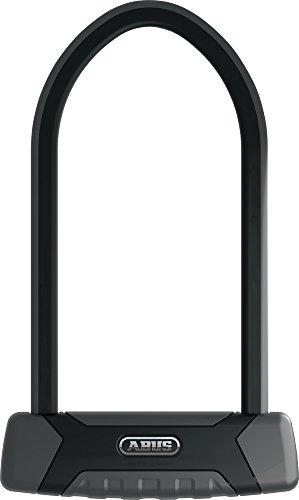
If someone has the tools/angle grinder and they are that dedicated , you are screwed no matter what lock. I use a very small lock to eliminate that someone will steal my bike by opportunity. Never heard of anyone getting their bike stolen if its locked to something during a gas station stop.
https://www.facebook.com/marketplace/item/183077176317761/
I think this is an excellent deal. It's a gravel bike but work fine on roads. Benefit is wider tire clearance for greater versatility. The wahoo computer itself is worth $200+. Treks from what I've seen run a little small so their 58cm should work for you.
Hey that's my ride!!! /u/jackyLAD, if you want to do more of a loop, rather than a there and back, you can ride up 9W and come back through the Palisades. https://ridewithgps.com/trips/52127825 (hill repeats are up to you).
Just be a bit careful, as the Palisades is likely a bit leaf-covered at this time of year. Especially as the road has been closed to cars (bikes can go around the gates)
NYCC future rides are morning rides; climbing-intense will be obvious in ride name and/or description, and GPS file for members. Most rides meet 10 minutes from RFK Bridge (good for Astorians) and go into northern NJ.
Also look for the CentruryPlus Radiator ParkSlope ride by in Brooklyn.
Hey OP, here's a ride I did earlier this year that crosses Highbridge. I was Manhattan bound, but it's pretty basic and if I remember correctly, they were 2-way streets, so should be able to do it outbound. Also, looking at the route, I bypassed SCT from Elmsford to Yonkers by riding Rt9A (again Manhattan bound) and taking Barney Street to access SCT. This too, you could do outbound, if you're worried that SCT has closures between miles 9 - 11
Thanks! The commute time is really helpful. I currently run 7 miles from work to Forest Hills (basically first part of the potential bike route) which takes 50-55min depending upon how bad the lights are. I figure I can do the same pace on hillside so it'll end up being 55min run vs N22 ride/wait time (google says 30min).
Do you have any thoughts on biking to F train in mornings vs folding bike and taking in onto the N22? The full commute path I came up with is here Commute Path and would greatly appreciate any feedback you have on it. Thanks!
Thanks! What you mentioned is pretty much exactly the route I've mapped out. Commute Path.
Would greatly appreciate any thoughts on alternate safer paths! I figure even if I only bike home and only during daylight months it's still worth it.
Do you think it's worth just biking to the F in mornings avoiding hillside as much as possible, or just buy a folding ebike and take it onto the N22? On google maps N22 to F route is faster than LIRR by ~15min, so I'm leaning towards that. Thanks!
Absolutely. Something like https://ridewithgps.com/routes/37354845 is a reasonable route. It's a few extra miles compared to what you planned, but once you get to Highbridge, you'll understand why it's worth it.
And, yeah, 138th in the Bronx is really going to suck. If you absolutely don't want to go all the way up to Highbridge, at least take something like 141st across town.
I've ridden from lower Manhattan to Milford. Mostly followed the East Coast Greenway. Happily surprised that the route through the Bronx was almost entirely dedicated/multii-use path. The ECG is very well marked through Westchester, though I missed one turn onto Rye Playland Parkway. Signage not as obvious in CT, and depended on bike computer routing (had preloaded the route)
I've subsequently ridden Milford to east of New Haven. very doable.
Here's the route I took to Milford: https://ridewithgps.com/trips/67162008
Let me know if you have any questions/concerns.
Take the LIRR to Massapequa. The Massapequa train station is right next to Massapequa Preserve, which has a bike path that heads about 12 miles north to the Bethpage Bikeway. The entire route is on bike paths. Most of it is in parks. Some of it is along the sides of suburban roads.
Here is the route on Strava, although note that I started from Bethpage:
Taco Time!: Grand Army Plaza -> Ocean Parkway -> Emmons Ave -> Belt -> Flatbush to Far Rockaway -> Rockaway Beach Blvd -> Tacoway Beach -> CrossBack -> Belt Parkway -> Emmons -> Bedford -> Eastern Parkway -> Grand Army Plaza
Just tried it (dat sawtooth elevation graph). Definitely lots of fun, but you're right about the stops and starts. Didn't really come anywhere close to suffering at any point. Best part is passing pedestrians on a downhill and then again on an uphill, and seeing their faces as they realize what you're up to :P
Here's my route to avoid the bad part of SCT. After crossing the TZB, come down Rt9. At Hastings, bear left and go up Farragut, then left on Ravensdale to 9A. Then take 9A just in to Yonkers and take a right on Barney St and join the SCT at La Lanterna. Then smooth sailing all the way through VCP and out on to Bailey and the Broadway Bridge.
After crossing TZB, because of SCT condition, I've taken Rt 9 south, then crossed over at Hastings to 9A and joined SCT in Yonkers at Barney St/La Lanterna and then it was smooth through Yonkers and VCP: https://ridewithgps.com/trips/67042717
Kind of depends on where you're starting.
I live on the Island and haven't done Ronkonkoma specifically but I've probably ridden most of the roads that will get you out there. The LIE service road is likely the most direct route but there's not much shoulder in Eastern Queens/Western Nassau and drivers tend to use it as a faster alternative to the actual highway. There are more hills on the North shore which may also affect your battery performance.
If you want to take some interesting routes through Queens, take a look at coming through Astoria and finding your way to the Long Island Motor Parkway bike/walking trail. You'll have to find your way back to the LIE from there and again hills getting back to it and fairly high speed traffic along it with limited shoulders until you get to maybe Roslyn road.
If you haven't already check out ridewithgps.com and map out a route. I did a not very specific one from the QB bridge, via Flushing Meadows Park and Cunningham park and it ran around 60 miles.
I did this last year: https://ridewithgps.com/trips/54701296. Avoids 9W between Piermont/Nyack and around Haverstraw.
Only thing you should do differently is that they paved/opened that Jones Point bike path. Hoping to do it soon, pretty sure you just bear right on River Rd up there off of 202.
The Concourse sucks. Even the parts that have bike lanes suck. I much prefer University. Edward L. Grant, which is the extension of University at its southern end, has a brand new protected bike lane, so if you can find your way over to that, you're pretty good. Take University all the way up to the reservoir, then Goulden Ave up the east side of the water. One you get to the end of Goulden, take Dickerson Ave and enter the park at the corner of Dickinson and Gun Hill.
The paths through the park can be a little tricky to follow. Just before you get to the weird spiral thing, the trail splits. Do NOT take the branch that puts you on the footbridge over the parkway; do through the spiral thing and you'll end up in the parking lot for the golf course. The entrance to the Old Putt Trail is just south of the clubhouse. When the weather's nice, the park benches by the lake are my favorite lunch stop, and the restrooms are the cleanest public facilities I've seen in the city.
Randalls Island itself (and the connector bridge to The Bronx) is very nice. The problem is that once it drops you on 132nd, there's no good ways from there. Maybe Prospect Ave which becomes Crotona Ave through Crotona Park all the way up to The Bronx Zoo, then Southern Blvd to the Mosholu Greenway. But, given a choice, I'd suggest doing more of your north-south in Manhattan, taking High Bridge from Edgecomb Park (158th St), and picking up University from there. If you do use Randalls, the footbridge from 102nd street is the way to go.
I know the area quite well, but I'm having trouble following what you described. If you can be more specific about your two endpoints, I could give you a good route.
The route Roadskater describes is basically this, and is hard to beat for nice riding. It's almost entirely paved paths through parks. If you wanted to go faster, the parallel Bronx Park East / Bronx Blvd is not bad either.
You absolutely want to avoid White Plains Road as a north-south route. That just sucks.
Instead I would recommend taking the Metro north Harlem line to Southeast or Brewster stations. Hop on the Putnam Rail trail and ride that back to the city (drops you in Van Cortland Park). If you start late the trail can get crowded with runners and walkers.
This in reverse: https://ridewithgps.com/routes/6144214
This is part of my "every street in The Bronx" project. These last few rides as I've ground out Riverdale and Spuyten Duyvil have been killers. One more ride to mop up a few streets I've missed and I'll have everything west of Broadway done.
I didn't actually see much traffic today. That may be the only positive thing to come out of this pandemic.
Just did it yesterday, this is the route I used. Great ride.
-River road vs. Palisades - River road much more hilly, but more scenic. I always take 9W because I'm comfortable with a little more traffic and some of the downhill sections on River Road are a bit sketchy with potholes.
-Definitely stay by the hudson
-Right before you get to bear there's a decent sized climb (300ft, 6-7%) and then you descend the same amount
-9W Market, Runcible Spoon in Nyack, and make sure to fill up on water at Cove Deli before you get to Bear, that's the last place to do so and there's no food or water on top of Bear (people might tell you there are vending machines but they are out of power because of a recent storm).
-The only sketchy section is the previously mentioned incline and decline right before bear. No shoulder on a windy mountain road for a few miles or so, just be careful and you'll be 100% fine. Also a slightly sketchy part before Haverstraw on 9W, where the shoulder is covered in gravel and other rocks and you have to bike on the road in a section where there's a decent amount of traffic.
Make sure you get off 9W before Nyack and take Piermont road instead, there's a death trap portion of 9W right before Nyack. The route I posted shows exactly where to go.
​
Last thing! If you're going up Bear Mountain and about halfway up the gate to the turnoff for the rest of the climb is closed, just take your bike around the gate and keep climbing!
https://ridewithgps.com/trips/50831060
It gets a little freaky when you have to cross Saw Mill River Rd (you'll know it when you get there). And then keep an eye out in Millwood, you have to ride along the road for ~ a mile and then have to take a right (Millwood Market will be on your left, btw: good restroom/refreshment stop). Or if you need a break, take a left off trail in Yorktown Heights, lots of options. The Brewster train station is about a mile from the end of the trailway.
https://ridewithgps.com/routes/4200512
I like this one. Hugs the shoreline as much as possible. Traffic isn’t all to bad as long as you get the Queens and Nassau part done with as early as possible.
Historical data confirms this - NYC is windier in the winter.
The winter also has more wind from the north and west, which lines up with my commute home - making it even worse.
Here you go: http://www.mapmyride.com/us/weehawken-nj/the-ride-to-montauk-06-19-2011-route-38064920
Start early. We were wheels rolling at 4am in Central Park, which got us into Babylon before 8am. It's nice to have the city at your back before it wakes up. The route after Babylon was fast riding. It is mostly on streets with four-way stops instead of lights.
I've posted this route before: https://ridewithgps.com/routes/32379338.
You didn't say exactly where you're starting from, so you'll either want to divert to the 102nd street bridge instead of the Willis Ave, or pick up the route in the 130's somewhere. The part through Randall's Island is really nice, so if you can swing 102nd street, I'd suggest that.
Once you get past Hunts Point, it's all really nice riding. The loop through SUNY Maritime is sort of the highlight of the trip, but if you're looking to cut some miles, once you're over the Unionport Bridge, make the turn onto Lafayette from Brush Ave and take that all the way over to Stadium Ave in Country Club.
The Unionport Bridge is currently under construction, but they're built a surprisingly civilized temporary walkway that gets you through the area.
If you actually want to end up at Co-op City, once you get to Bartow Circle (mile 21.5 on the route), head west on the other bike path that takes you back over the Hutchinson River, then down a funky little switchback to Bartow Ave.
Another alternative to consider is getting the ferry at 90th Street and taking that up to Soundview to pick up the route from there.
Follow the Ride to Montauk route. Here's one example: https://ridewithgps.com/routes/28579249 It tends to sidle onto quieter roads when possible. The detours tend to be quite scenic.
From Prospect Park, you'd head NE to hit it. Enjoy. It's a great ride.
I've followed the East Coast Greenway up as far as Stamford. Not as nice riding as the rail-trail route to Brewster, but not bad. I'd probably deviate from the official ECG route through downtown Port Chester and find some nicer side streets. Ditto to avoid Playland Parkway in Rye.
You're basically following the Metro North New Haven Line the entire route, so you can get the train back to Grand Central wherever you want.
Here’s something to get you started:
https://ridewithgps.com/routes/6790816?no_redir=1
You can see the 9W alternates for the 4-lane section in Englewood Cliffs.
State Line Lookout is pretty amazing, but the road up there is rough concrete.
The entrance to Henry Hudson Drive, sometimes called River Road, not to be confused with the street actually called River Road, is here: https://goo.gl/maps/fiRsG3hr9XuQCZh38
8 beautiful miles, very light car traffic, 3 steep hills and the last one is the longest.
Hope this helps
Don't know where in Queens you are, but this was a good ride from 5BBC. Little Neck train station to Prybil Beach and Centre Island.
https://ridewithgps.com/routes/28258953 https://www.strava.com/activities/1799850024
Nice photo op at the top of the Sea Cliff Memorial. I would think Prybil Beach is closed (it's only for residents too) so you'd have to make some changes to the route.
If you're not feeling navigating or adding extra climbing, you can ride 9w and link up easily to those big climbs. I never ride Bear, I just ride the tors or do a 7 lakes drive loop
https://ridewithgps.com/routes/22976449
Is a fun loop I planned, easily done from the train station. I drive, but the train station is real close. And there's an ice cream and hot dog place in the last 10 miles or so. Rolling hills, nothing huge, a nice long and fast descent at the end.
I've did a ride similar to the one above few years ago except I came from Orient Point and with an overnight in Riverhead (via the NL ferry and LIRR, work schedule didn't allow me to ride 100% of the way from the ferry). From there I worked my way down to the south shore and to the City. Traffic only got really bad once I was in Massapequa on RT 27 proper for about 3 miles. I stayed off the major roads as much as possible and had a fairly good ride. Then i went to Newark to explore a bridge that had stymied a friends bike from Maryland the summer before. That was fun...
I've also done Port Jefferson to the Orient Point (via the Shelter Harbor ferries and a portion of the South Fork). The RT 25 section of this ride kinda sucked, stupid heavy traffic and quite a few "tcompensators" (jacked up trucks blowing smoke w/truck nuts on the back) squealing around. Southwest of Riverhead was pretty nice rolling terrain (stuck to the "north coast" of the fork if that makes sense) with very little traffic. There weren't a whole lot of services once I got past Riverhead so plan accordingly.
Overall, if you're on the move early enough you shouldn't have too many issues with traffic on the western end of Long Island. I'd stick to the south shore as there are a lot more side roads to use and less mid day traffic.
Riverhead to Newark- https://ridewithgps.com/trips/2919856 Port Jefferson to Orient Point- https://ridewithgps.com/trips/2745778
Cold Springs gravel ride - killer ride, starts at the cold springs metro north station
Kittatinny ride out of Port Jervis - really nice and scenic
And I've ridden up to the Catskills up 9w to kingston then past the ashokan reservoir, and while I probably wouldn't recommend that.. I would definitely recommend figuring out a way to get up to Kingston and taking 28a into the catskills, to route 42 over Peekamoose, then route 55 through Minnewaska to New Paltz.
7 Lakes Drive and just exploring Harriman is nice. Definitely beats 9w-to-Bear-and-back
That's a curb cut. Former parking lot
I have a bunch of routes here - all start near GWB or a train station that shouldn't be hard to get to from the city. One caveat is that I haven't ridden anything that ends with an *, but let me know if you do try one out and I can update the route to avoid any issues you encounter. Most of these are pulled from local people I follow on Strava like some of the Rapha NYC guides and other racers.
Also happy to download the GPX for any of those and send them to you via DM if Komoot is a pain and doesn't allow you to export.
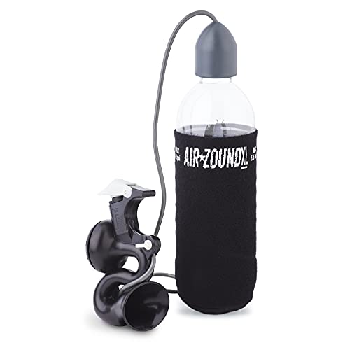
It's loud AF, but it does the job, and more importantly gets the attention of pedestrians blindly stepping into the bike lane: https://www.amazon.com/gp/product/B006TDEV20/ref=ppx\_yo\_dt\_b\_asin\_title\_o00\_s00?ie=UTF8&psc=1
I have this on the back. Stone alternates between red and blue, which I read somewhere is better at getting attention but who knows. You can also do straight red or blue.
I have this on the front.
No complaints about either
I also have a monkey electric 210 on the rear wheel and a 232 on the front for side viz and also for fun. Sadly monkeylectric went out of business.
I got a very large raincoat off amazon that works fairly fine. Your pants and shoes still get wet though, but something that you can fit over your backpack is solid.
Mine had sleeves which are kinda nice in some ways because I can see my hands but in other ways I think something like this might keep you dryer.
I use the lock you linked to on amazon in NYC everyday and it works great. I've never had any problems 3+ years. I also use this convenient bottle lock - https://www.amazon.com/Kuat-BL03-Bottle-Lock-Pink/dp/B0064AW2VK/ref=sr_1_1?s=sporting-goods&ie=UTF8&qid=1496110469&sr=1-1&keywords=kuat+bottle
I use one of these
https://www.amazon.com/GoNovate-Bluetooth-Playtime-Magnetic-Chargers/dp/B01LWUFECM
There are a bunch on amazon, some cheaper, some more expensive but they all are the same cheap bluetooth earbud that come as one. If you get a ticket I'm sure you could use the receipt to prove there is only one earbud.
They arent the best quality but at $10-$20 bucks in price I don't really care plus I just listen to podcasts with them.
I use that: https://www.amazon.com/gp/product/B07DN84354/ref=ppx_yo_dt_b_search_asin_title?ie=UTF8&psc=1
​
It's pretty great and minimalistic, and the leaning help for storing and taking minimal space at human height (if you put it high enough) and uses most of the space above human head height.
​
We have 3 of them now, never had an issue, one of the bike is an old steel Peugeot that weights a pig...
I have road pedals on my bike but put on pedal adapters when I use it for errands and such. Here is a link:
https://www.amazon.com/gp/product/B07CGWQJVT/ref=ppx_yo_dt_b_search_asin_title?ie=UTF8&psc=1
I recently got one of these and have been happy with it, I hook my bike up to my trainer to use it and put a towel underneath, but it could probably also work in the shower/bathtub as well.
https://smile.amazon.com/dp/B07YWQYC83/ref=cm_sw_r_cp_apa_i_v.yoFbGY7297F