
What are
/r/NYCultralight's
favorite Products & Services?
From 3.5 billion Reddit comments
The most popular Products mentioned in /r/NYCultralight:


![[Upgraded] CHAFON M3 USB C Cable 60W, 4 in 1 Multi Charging Cable Zinc Alloy Magnetic Keychain EDC Fast Charger Dual Type C/IP Connectors for Portable Charger MacBook Phones Tablets (3rd Generation)](https://m.media-amazon.com/images/I/41AnH7IXOSL._SL500_.jpg)
The most popular Services mentioned in /r/NYCultralight:
AllTrails
Ride With GPS
The Weather Channel
AccuWeather
Weather Underground
The most popular reviews in /r/NYCultralight:
What's up NYC Ultralight. Finally escaped Brooklyn for an overnight hike. First time since February. It's been tough times for us out there. I just got a car to and am looking for some other NYC hikers to do some car to car hikes soon. Trying to finish up the Long Path in the Catskills if anyone is down. Made this little edit after an overnight in Harriman. Was one of the best overnights I've done across the park honestly. With some slight variation like leaving from Tuxedo and going over Bald Rocks, and finding a better spot to camp at this could be a near-perfect weekend trip.
We took the train from the city to the Tuxedo stop and then a short cab ride to the South fields (West side of Harriman State Park) to start the trail. From there we went North East eventually meeting up with the AT and the Long Path. Along the way we went by 2 mines including the Bradly Mine which was super rad, even has an archway. Definitely check that out if you have not before, it's slightly off-trail. We Stealth camped at what was supposed to be a lake but was more of a pond, Lake Nawahunta. I don't recommend doing that as it's right off SevenLakesDrive and sucked for swimming which is why we wanted to go there. The next day we followed the Long Path North, went for a swim in Turkey Hill Pond, illegally checked out this old Furnace, summited Mt Torne (Best View in the park I think), swam in popolope creek and linked back up with the AT to cross the Bear Mt Bridge. From there we took the hard way up Anthonys Nose (Super dope but tough scramble) and then descended to Peekskill and caught the train back to Brooklyn. Ended up being 23 miles total with 4k+ of elevation gain. Deffelty was an ass-kicker with 90+ degree heat that weekend after being couch-locked the past 5 months. AllTrails link below
I got an X shaped one off AliExpress, it's 32cm tall, there are larger ones and smaller ones, so trend larger because they will sit too low otherwise. It's nice. Quick to setup and light, only 390g.
I'd link the original but the seller no longer offers it so just look for one that's 32cm tall.
here's the closest i could find on Amazon
Try a linkup in the high peaks area. Something like this link below and you can also add nippletop or dix/macomb if you want a longer trip. Just be careful with the icy “alpine” condition this time of the year and be prepared to get your shoes wet. https://www.alltrails.com/trail/us/new-york/great-range-grand-loop
Forecast says "Heavy to Severe" Thunderstorms on the way for today Saturday 6/27 and early Sunday 6/28. I'll see you all in the woods Sunday and Monday night instead. Spending today washing pounds of merino wool instead.
Did this awesome overnight hike from Tuxedo through Harriman to Peekskill this weekend. We started a little North of the Tuxedo station to check out a trail we had not hiked before. Then took the Long Path North before cutting East to the bridge. Ran up the Torne and sawm in the river first. Took the steep nose route up Anthonys Nose and made it to Peekskill in time for a beer at the brewery. Was a really awesome hike for an overnight with 3mines, lakes, and peaks. I would highly recommend it from Tuxedo station so you can go across bald rocks as well. Make sure not to miss the Bradley mine which is slightly off-trail but worth checking out.
Thanks for the tips! We're thinking of doing an out and back to Peekamoose Blue Hole. I've been swimming there before, but haven't don't too much hiking around there.
https://www.alltrails.com/explore/trail/us/new-york/long-path-section-16
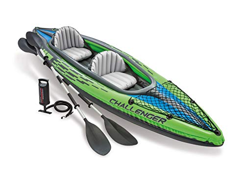
Would anyone from this sub like an inflatable kayak? Me and partner bought it a few years ago for a specific trip and have only used it that one time. Now it's just taking up space. We live in Astoria and you would have to pick it up. https://www.amazon.com/dp/B00177FIJ8/ref=twister\_B08976YQX7?\_encoding=UTF8&th=1
I had an excellent weekend hiking in Harriman this weekend. By combing a whole bunch of trails, I hiked a lot of scenic places and new areas of the park. The app said I hiked 36.7 miles train station to train station, I wonder how accurate this is since I wandered around and bushwhacked quite a lot. I’ve been fooling around with AllTrails trying to record hikes and what not but it’s really destroying my phone battery. Can anyone suggest a better option?
https://www.alltrails.com/explore/recording/recording-sep-08-7-03-pm?p=-1
Here is a fb post from 2016: https://www.facebook.com/LongPathRaces/posts/interactive-map-for-the-srt-runhike-with-nice-weather-its-time-to-start-planning/1220225658006991/ with a link to this interactive map: https://www.alltrails.com/explore/map/srt-v2
> check out the updated interactive map for the SRT Run/Hike, which shows starting points for the 70, 50, 30-mile and 1/2 marathon courses, as well as check points and the finish. There's an elevation chart (button in the lower right), and if you zoom in, you can see all the water sources along the course (plenty of water!)
looking back on this past weekend:
I took the Hudson Line MNRR to Beacon to walk a route to Cold Spring that I had written when Mt. Beacon still had ice on it.
https://ridewithgps.com/routes/29329534
took a small diversion, an out and back on the yellow 'undercliff' trail, for some last looks of the Hudson River after Mt. Taurus and ended up with 3,333' over 12 miles
Hot 'n humid day, carried 2L reservoir in my pack plus .5 L or so in a smaller smartwater bottle and drank all of it. considered filtering some more at the Cornish Estate ruins, but decided just to suck it up until getting into town. Lots of hikers out, including on all the connector trails; lots of groups on the peaks. Bug pressure was fairly light, albeit annoying growing obnoxious in the forested descent into Cold Spring; eventually took off on a trail run just to drop the flies.
Good day out on the trail, def worked my muscles out on the climbs and even more so coming off the peaks on steep trails. Would recommend to a beginner hiker looking to find out just how wrecked they can be from hiking :D
X-Mid 2P is live on Amazon now: https://www.amazon.com/gp/product/B08FXW6T2Z
Ordered one because my fiancee is not as enthusiastic about tarps as I am and I'm hoping to get her at least car camping this year. I'm also hoping it'll be nice for some bad weather trips since I'll have a little more space and confidence in not getting wet.
Did my first pandemic-era hike (aka 1st hike since March) at Mt. Taurus (across the river and north of Harriman, just south of Breakneck Ridge). Breakneck was INSANE as we drove past, but Taurus (Bull Hill) parking lot was only 3/4's full at 8:30am on Sunday. Take aways:
- Not hiking for 5 months and thinking I would be in "hiking shape" since I've consistently been using my treadmill was silly of me. Treadmill incline at 15% (highest mine goes) is not a substitute for real hiking lol.
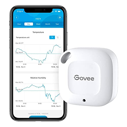
- I don't remember if it was it's own thread or just in the UL weekly, but they were talking about lightweight thermometers and one mentioned was the Govee so I snagged one since the other popular UL thermometer I already have and don't like. Maybe I'm missing something, but it looked to me like the Govee would only work if I had it paired with my phone via Bluetooth, which flies in the face of being able to conserve battery in airplane mode. If so, I may have wasted $15.
- The reason I had not hiked in so long is completely Covid19 related, so I was really curious to see what mask usage would be like while hiking since I was stressed. I'd say that at least half of the people we passed "masked up" once they saw us. I had it in my brain that the majority of people would just say "we're outside in the woods, I'm not masking". The fact that at least half did put on masks once they could see us was a pleasant surprise.
- Wowzers did I miss being out in the woods. It was such a nice reminder of how much I love hiking, and I think as long as I try to find places that I think won't be super-crowded I'm going to try and get out there and hike as much as I did pre-pandemic.