
What are
/r/oregon's
favorite Products & Services?
From 3.5 billion Reddit comments
The most popular Products mentioned in /r/oregon:


The most popular Services mentioned in /r/oregon:
AllTrails
Weather Underground
TripAdvisor
Airbnb
500px
BitChute
ConsumerReports.org
Windy
Ride With GPS
Roadtrippers
Healthcare.gov
Nextdoor
GasBuddy
Wikitravel
WikiLeaks
The most popular Android Apps mentioned in /r/oregon:
The most popular reviews in /r/oregon:
This is my favorite book about this subject-
https://www.amazon.com/Nez-Perce-Summer-1877-Nee-Me-Poo/dp/0917298829
Fascinating bit of western history that was covered extensively by newspaper accounts at the time.
You won't have to bug out at all. You are very lucky! You won't have to go anywhere! You're in the right spot already. Just do your regular shopping before the weekend and you should be OK. Stock up like you would before a snowfall.
Tips might include having extra glasses for people, download an eclipse timer app, and have fun!
And don't go firing up IE either: http://www.cnet.com/news/stop-using-ie-until-bug-is-fixed-says-us/
Of course, there's no one at the wheel at Cover Oregon to alert unsuspecting users of this fact.
Ah! Totally understandable. Sorry to hear about the arthritis, that can really be terrible. One of my best friends suffers from Reynaud’s and we have had to figure out some adjustments for her when the nights are even in the low 60s. USB-powered electric hand warmers, and we always give her our deer hunter bag. It’s $130 and -35. If you get the big one, it can be unzipped and used as a giant family comforter, or two of them can be zipped together. Anyway, not that you asked, but just something we found that works and is relatively affordable compared to doing expensive down sleeping bags.
TETON Sports Deer Hunter Sleeping Bag; Warm and Comfortable Sleeping Bag Great for Camping Even in Cold Seasons https://www.amazon.com/dp/B00A4VLLX0/ref=cm_sw_r_cp_api_glt_fabc_K43V51B0ESZQ18FX82WA
Identify theft and intercepting CCs and checks.
https://www.amazon.com/dp/B008HVH502/ref=cm_sw_r_cp_apa_glt_fabc_0SJ8J0GRYJZ1F14ZJ6VX
First thing I bought when I got my home in SE Portland. Haven't had an issue since. All my neighbors have had their mail stolen, I have not.
Sign up for USPS informed delivery. It's free, also ensures you know exactly what is and has been delivered so you can notify the parties if it is stolen.
https://dictionary.cambridge.org/us/dictionary/english/ghost
>ghost noun (MEMORY) >[ S ] literary a memory, usually of something or someone bad: > >The ghost of the old dictator still lingers on.
Of the many sites, the most reliable in my opinion is PurpleAir for current conditions:
https://www.purpleair.com/map?opt=1/mAQI/a10/cC0#9.84/45.4835/-122.5482
The reasons for this:
- You get to look at multiple monitors.
- ~~Each monitor~~ Some monitors, if you click on them, have a confidence level.
- This confidence level comes from the fact that ~~each monitor~~ some monitors actually have two measurement devices built in. Confidence is 100% when the two devices measure the same thing.
For predictions, that's much more difficult, as there are virtually no services that do this kind of prediction. The 2,000 AQI claim is based off of the modelling on windy:
https://www.windy.com/-PM2-5-pm2p5?cams,pm2p5,45.069,-122.772,9
This is based off of satellite data, which uses reflected light. Because of this it is likely (but obviously not guaranteed) that the numbers here could be high.
However, in this situation it is likely more prudent to prepare for the possibility that it's not. At this moment, the windy data and the purpleair data actually match fairly well, which is not encouraging.
EDIT:
An additional note: some of the AQI monitors are actually indoors, not outdoors, and not all of them are properly marked as such. This is what causes the enormous variance that some people are seeing between various websites, or even on the same site. For instance, at the moment Salem has one monitor reporting an AQI of 80 right next to one that's over 300. This is because one of them is indoors.
No problem, further south you have Honeyman park which has some really cool sand dunes. Also the hobbit trails.
No. Well the time part is pretty close
I-5 runs for 308 miles from the south to north borders.
308/65=4.74 hours
308/70=4.4 hours
Different vehicles have different sweet spots for best fuel efficiency. 55MPH was geared more towards old cars from the 70s and it was raised to 65 because people were irritated by it.
If everyone drove properly and you could sustain 70MPH in the left lane you'd get better mileage than doing so at 65MPH in many vehicles. Accelerating is more energy expensive than sustaining a speed.
2000 RPMs at 70MPH and 2000RPM at 55MPH use the same amount of gas in the same amount of time but with 70MPH you spend less time at that RPM.
There are at least a number of situations documented that show no raise in accidents/injuries when speed limits are raised from 65 to 70MPH source. In another with a short term study of post speed limit increase traffic accidents were down source.
Don't count on buying a house unless you have a serious bankroll
http://www.marketwatch.com/story/portland-ore-housing-market-is-on-a-record-roll-2015-10-09
Job growth just hasn't managed to keep up with immigration here.
First, you don't have to be a dick about it.
Second, the average wage in Portland for a Pharmacy Tech is about $27,000 according to this site. That's about $13.50 per hour at 40 hours per week. Lots of jobs are like that and it's significantly better money than the current minimum wage.
I'd recommend Private Internet Access. It's got a good reputation, it's affordable and I haven't noticed too much of a drop in speed, depending on the node I connect to. I run it on my PC, Android phone and even my fire TV stick.
Ouch! I am also bad about sunscreen... I will bring some tomorrow for sure though!
I think the trailhead is called green lakes? It's about 10 miles we are just going to hike in to camp by the lake. Here's the route: https://www.alltrails.com/trail/us/oregon/green-lakes
Are the mosquitoes bad right now?
There are quite a few wineries down here in Eugene. It's about a two hour drive from Portland. You could drive down here, get an entire studio or apartment on Airbnb for less than $100 a night. I recommend one of the rooms/tiny houses in south Eugene- the college kids don't make it down there. Do some wineries one day, hit up the breweries at night. Head to Florence (one hour drive from Eugene) and check out the Heceta Lighthouse, do some light hiking, have a picnic or go out for some seafood.
The current and overnight temperatures are basically tying with the all-time highs. The forecast for the day is far below the record, but the actuals are already well above some forecasts.
This site shows the historical min/mean/max, 75th and 90th percentiles, and up to three different forecasts on the same chart:
https://weatherspark.com/#!graphs;a=USA/OR/Cannon_Beach
None of these three forecasts have it over the record on Saturday (88F), but two of them have it pretty close.
Lies. there's video showing that anti-fa was throwing multiple objects (which is assault) even before throwing the bomb at PP. PP only "charged" when one guy who seemed to be right near where the bomb went off refused to take the assaults any further. https://www.bitchute.com/video/J7sv20ytrQg4/
One thing that I'd like to change is that a state representative is just that, a representative of the majority wants and needs of the district they serve. Every concerned, registered voter should be able to have a voice and a vote on legislation in the house. To do this, I've created a community forum for people to discuss and vote on upcoming bills. If I get elected to office, I'll lock this down for CD2 registered voters so we all can discuss, write, amend, repeal and vote on legislation.
You probably shouldn't rely on this app to figure out whether mushrooms are safe to eat, but Seek by iNaturalist will try to identify any organism using your camera. I ID'd some mushrooms near my work the other day. It works best on wild plants in good lighting but I've also had good success with bugs, pets, and roommates.
https://play.google.com/store/apps/details?id=org.inaturalist.seek
Glad to help! Even if you don’t see monarchs, go check every couple days. They’ve been spotted in Oregon and Washington this week. I just got lucky seeing one and then happened to see a thread on Nextdoor about what to look for.
Here’s the migration tagging that coincided with our fortuitous caterpillar growing:
https://ucanr.edu/blogs/blogcore/postdetail.cfm?postnum=27559
And here’s the simple terrarium. I’d guess 10 caterpillars per habitat is okay, they eat A LOT of milkweed in the last couple days. It’s convenient to have an empty clean one to move everybody into, then clean out the other.
https://www.amazon.com/dp/B074ZHXF48/ref=cm_sw_r_cp_api_glt_fabc_GY3CKQ95C5A7P2AF3MMT
I'm seeing significantly different readings for Portland on a few different sites, ranging between 434 (AIRNow) and 281 (IQAir).
Weather Underground has a map showing measurements from all over town. Some of the differences are striking.
You understand that a flash flood after a fire is more than just water though right? It’s mixed with ash and debris. If you remember the fires from 2018, flooding killed 15 people. https://www.wunderground.com/cat6/least-13-killed-flooding-mudslides-fire-scarred-southern-california
Where this actually is. Southbound 5 entering the San Fernando Valley, interchange with the 210. Sorry, couldn't help it.
Fort Rock - weather permitting. It's a drive, but... pretty cool place to check out. Be prepared out there, though, it's extremely remote.
If you have time or are planning on visiting the beaches in Oregon while you're on spring break, I'd HIGHLY recommend Drift Creek Falls outside of Lincoln City. It's not really a day hike, it's a pretty short and easy hike, but its beautiful forest, and has a cool suspension bridge you walk right over a waterfall. Plus, it's maybe 15 minutes outside of Lincoln City, so you can see the beach, visit some little shops and get some saltwater taffy, or visit Chinook Winds Casino if that's your thing.
Fort Rock. Something you won't see back east. The coast? I'm not a fan, it's cold and chilly.
Compare and contrast:
Hewlett Packard has a branch or something over in Corvallis- home of Oregon State University. They're known to recruit electrical engineering graduates. Good luck.
That's Broken Top in the background. Just east of the South Sister, and no too hard to get to via the Cascade Lakes Highway and a day hike: https://www.alltrails.com/trail/us/oregon/broken-top-trail-to-no-name-lake-and-bend-glacier
We actually have marginally lower gas prices than CA, WA, or NV, and less than a penny higher than ID at the moment.
So, obviously, those states are in part making up the difference in higher gas taxes. So do we like it better if the money goes into state coffers, or into gas station attendant pockets?
I used temp-mail.org/ for my email if anyone else is concerned about receiving spam from the GOP, though I haven't received anything in the inbox after submitting my responses
Directly above the chunk of concrete is the Gales fire, directly above the left most black stump is the Ninemile fire. I know it due to taking the photo and being able to match the smoke column with active fires on the map. https://play.google.com/store/apps/details?id=com.rmtheis.fireguard
If you just want a map, caltopo.com is where it's at. I download and print them from there. You could save the file to your phone.
If you want an app, Back Country Navigator is awesome! https://play.google.com/store/apps/details?id=com.crittermap.backcountrynavigator
You can download maps and use them offline, record your tracks, etc. Not sure of the limitations of the free version, I have the paid version. Hope this helps!
There are a few lesser known parks that are off the beaten path. I would recommend Gold and Silver Falls state park when you are near Coos Bay. There are some fun airBnB places, too. Here's one near Bandon where you can stay in a Teepee!
I just searched for "old growth willamette" and found some stuff like this:
https://www.alltrails.com/trail/us/oregon/hackleman-creek-old-growth-trail
i worry about snow, as many of these old growth sections are at higher elevations. good luck!
I think I got this stuff and I wasn't as thorough as u/slobone. I had a pretty good idea how they were getting in and just sprayed those 2 window frames. It worked for about 3 months or so and then I had to re-apply.
Reserveamerica.com for state park reservations. Recreation.gov for federal campgrounds. You will run into some closed campgrounds by October. Look for nearby dispersed sites, don’t block the gate, LNT.
https://www.amazon.com/DeLorme-C2-AE-Oregon-Atlas-Gazetteer-Delorme-dp-1946494062/dp/1946494062/ref=dp_ob_title_bk Our ‘crown lands’, lol, are open for free dispersed camping. I.e. National forest, BLM managed land. You will often find established sites near water just off forest roads.
Mind the October weather. It’s a transition period. It could be summer at elevation or you could wake up to several inches of snow. Every year someone needs rescuing early in the season because of the weather.
Edible Wild Plants: Wild Foods From Dirt To Plate
The author also does Oregon workshops.
That too. But every kind of “middle housing” is met by neighbors who scream “but mah property values!l😱 this is true across the board- red or blue towns. There has been some movement very recently on ADUs and duplex conversions but we are 20 years behind the 8 ball on this.
To read about the connection between zoning laws and racism, The Color of Law has a lot about Portland history. Spoiler Alert- a lot of what people love about SE Portland is tied to racial/ economic discrimination. As a 20 year past resident of that area it was kind of sad to learn.
Yea that sucks. Something I learned recently was that there are immense federal grants for building roads but the cost of maintenance falls on the cities. It makes roads look really cheap but as they start to wear out after 15+ years the cost of maintenance which does not include all that grant money from federal sources is really hard to gather up. The amount of roads we have as a taxbase to support compared to the amount of tax revenue makes it really hard to maintain it all. No matter where the money comes from it's going to be expensive and actually the problem is getting worse because for cities to stay afloat they literally have to build new developments and get that federal $$$ to help repair the roads for which they don't have the money.
This decision to sprawl and build more roads without a concern for the $$$ to maintain it started after WW2 with the assumption that a modern country will involve everybody driving everywhere. It has taken a long time for that mistake to catch up with us, roads last about 30 years before needing to be repaved but it all comes due eventually and then you run into cases where you have bridges collapsing in PA for example. Also after WW2 we had immense amounts of money from all other countries in debt to us, but what we did with that wealth was to build liabilities.
A really worthwhile read/listen I keep passing around on reddit about this is this book by written by a PE civil engineer with decades of introspection from his career and the economics of roads:
You can also preview his talking points in some of his blog posts such as this one: https://www.strongtowns.org/journal/2022/2/21/we-need-to-embrace-traffic-congestion-not-fight-it
Here you go. This way it’s not their property.
Petbobi 30 Feet Tie Out Cable Chew- Proof for Dog Stake with Durable Spring Rust- Proof Training Tether Reflective Training Runner Pet Lead Great for Playing, Camping and Backyard In Ground (Blue) https://www.amazon.com/dp/B07CXJGZY5/ref=cm_sw_r_cp_api_glt_i_9A2X1ZYS5MQQXYQ3A98V?_encoding=UTF8&psc=1
https://www.alltrails.com/trail/us/oregon/wildhorse-lake-trail--2
Wildhorse lake trail from camping by the lake.
The steens summit road ends near the wild horse lake trail head to go down to the lake.
The end of the road is about 9000 feet.
There is a mile long or so trail with approximately 1100 feet elevation change to the summit.
If you are training I think you could easily use that area and camp near the lake which is amazing. Or just camp at the summit or road or wherever.
I can get you specifics if you need. I know a guy who is pretty much an expert on that area.
it was my first trip to SE Oregon. going back next month.
we went all over Oregon and Washington... this flickr set has all the photos so far...
https://www.flickr.com/photos/bodiegroup/sets/72157644644389181/
This is about the time of year I think about making the opposite move.
https://www.wunderground.com/forecast/us/nm/silver-city - looks quite pleasant!
There is another Whetstone, Opal Creek, Bagbe it is a hike though and it is really rainy and cold in this area right now.
https://www.alltrails.com/trail/us/oregon/whetstone-and-opal-creek-to-bagby-hot-springs
or even offer short backpacking trips where you drop-off and pick-up and lead the way. Many foreign visitors would like to see the backcountry sights in oregon but the planning and logistics make it daunting. Just checkout /r/EarthPorn and sort for top all time. there are tons of pictures from Oregon but most of them are somewhat hard to get to by car. For example Jefferson Park.
I did the route that goes from the first fee park trailhead (Connor's Camp Trailhead?) up to the peak. All trails said 5.2 miles round trip but the incline gets pretty wild in some spots, especially for someone new to trailing like me.
It was actually kind of creepy due to the clouds and light rain... and my trailing partner wasn't able to make it that day. I think i'm packing bear spray from here on out lol.
The Goodman trail off Highway 58 might be an option. Lots of nice trees, newts, and not a lot of slopes.
This is so much better isn't it:
https://www.shutterstock.com/image-photo/aerial-view-affordable-tract-housing-development-643337218
​
​
How old are you? Are you on a student visa? It is good to ask the question. I am wondering if there is any possibility of doing something like babysitting. I find many people are always looking for a babysitter and can't find one. If you are a student, it might provide the flexible hours too. Nextdoor.com (which requires you to state a specific address) is good for advertising services.
The link above gives the location in Washington, near Lyle. However, I didn't really see anything like a row-planted stand of poplar trees real close to there on Google Earth's pics. There is a similar grove a bit south of Salem, on the East side of the Interstate 5.
Well, in that case. You can purchase health insurance from any private or public insurer in Oregon, and you can sign up using Cover Oregon, if you like. The website is working fine at the moment. In fact, it's doing so well that our politicians are planning on getting rid of it (because their assholes).
However, if their plans to destroy the extremely expensive and now fully functioning public service succeed, you can always use the federal website healthcare.gov. If you need any further help using the internet, you may want to try using google.
The blue pool truly is stunning! More info here: https://www.alltrails.com/trail/us/oregon/tamolitch-blue-pool-via-mckenzie-river-trail
Traveling to Ecola state park/Cannon beach with a car. Will be traveling with the family, there is one infant who is 6 months old. I would like to goto Ecola State park to the viewpoint where all the pictures of Cannon beach from above are generally taken. How far is the hike from the parking lot to the viewpoint? Are best times for pictures morning or afternoon (including people, don't want to have shaded face issue due)
Afterwards, hoping to head to the beach for the day with a portable BBQ, is this possible? How is the weather in Mid-July/August? Windy? My main concern is or 6 month old. We also have someone who isn't too mobile with us. Any other places you recommend we go since we're in the area? This is only a day trip. Coming from Seattle.
Would you recommend a different beach for picnic/bbq/kids to play?
Also, this picture is taken from the main viewpoint at Ecola I assume? https://www.alltrails.com/api/alltrails/photos/19273347/image?size=extra_large&api_key=3p0t5s6b5g4g0e8k3c1j3w7y5c3m4t8i
If we have an older grandparent come with us, do you see any issues with them access to the viewpoint or beach? They can walk on their own but they just rather slow.
From uptown Oakridge, take Salmon Creek Rd (aka FR 24) eastbound. That's pretty much it. It'll be about 17 miles of asphalt and then 7 miles of gravel. Just past the end of the asphalt there will be a sign. Here's a map.. Note that Goddards Grove is not on FR 24, it's just off it down a short road.
here's another anecdote
Sheriff of Kenosha County on an unhinged rant calling for "warehouses" to store people in inhumane conditions (he was responding to some shoplifters)
I live in South Salem and have a homemade antenna I made from some scrap lumber and wire coat hangers - it's up in my attic and I pickup NBC, CBS, etc etc etc just fine.
I started with a store bought antenna and it was shit, the homemade option works 1000x's better. This is what I used: http://www.consumerreports.org/cro/news/2009/04/diy-antennas-build-your-own-dtv-antenna/index.htm
This person is the perfect example of the Dunning-Kreuger effect
He talks with confidence of a smart person, but says words which shows a lack of actual education on the problem.
People, who are also smart, but educated, and focused their careers on this very problem explain why almost never works.
I suggest you read some Mancur Olson (1965)
https://www.amazon.com/Logic-Collective-Action-Harvard-Economic-ebook-dp-B00DMKS0WU/dp/B00DMKS0WU
I wear these Bogs Boots on my coast trips and beach walk for shell/rock collecting and shellfish harvesting, and they are phenomenal. Any rubber boot is what you want, waterproof, keeps sand out, and very easy to clean.
https://www.amazon.com/gp/product/B071K5PF1G/ref=ppx_yo_dt_b_search_asin_title?ie=UTF8&psc=1
>Welcome to Oregon Exposure Notifications, the official Exposure Notifications app of the state of Oregon in partnership with the Oregon Health Authority. Thank you for joining thousands of other Oregonians to help stop the spread of COVID-19 in our communities. The use of this app is voluntary, and you can turn it on or off, or uninstall it at any time. The app will not collect or store any of your personal information, your contact information or your location (GPS). > >Using your phone's Bluetooth technology, the Oregon Exposure Notifications system continuously exchanges anonymous keys (random collections of letters and numbers) with the phones of other nearby users. Based on the strength of the Bluetooth signal (which indicates how close you were to a person), the date and duration of the signal, the app notifies users if they've have been near other users with a positive COVID-19 test in the last 14 days.
Washington is using the same system but uses a separate app. You can install both. https://play.google.com/store/apps/details?id=gov.wa.doh.exposurenotifications
For those parents and guardians who can afford it, I highly recommend the Spectrum series of workbooks for kids in kindergarten through 8th grade. Available on Amazon.
They cover multiple topics.
Example:
https://www.amazon.com/dp/1483808696/ref=cm_sw_r_cp_apa_fabc_gvb5FbJG32HYK
I have this problem too. I bought plastic spike mats (they don't harm) for under our windows, an ultra sonic movement detector, that sends off noises you can't hear but cats can, and I sprayed my yard with an orange based deterrent.
The spike mats are the BEST.
https://www.amazon.com/dp/B07SDCK7WJ/ref=cm_sw_r_cp_apa_fabc_jDw0Fb6473VGZ?_encoding=UTF8&psc=1
The clear masks aren’t for the hearing-impaired person—they’re for everyone around them. These are similar to the ones we got at work, which are fine: https://www.amazon.com/dp/B08HCPYX7P/ref=cm_sw_r_cp_api_i_t0UJFb8THRMB5
Embrace using public transit for a bit to give it a try. (Here's the app I use for figuring out times https://play.google.com/store/apps/details?id=com.circlegate.tt.ezride) Also being from California and not having access to a similar system, I wanted to just dip my toe in at first. I took transit when the route was simple and I wasn't in a rush to get to the destination and now I use it whenever it's a good choice (even if a bit longer than a car ride... to a point).
Beaverton is more diverse than Portland and it's not without a few decent food options (Frank's Noodles and Oyatsupan bakery are in the same area and both worth checking out).
There's some great hiking/walking options around. Tualatin Hills Nature Park is a great mostly flat, partially paved area but it's beautiful. Forest Park isn't very far away either and it's filled with interesting trails.
WinCo is a great grocery store option, but Beaverton also has a pretty amazing Farmer's market on Saturdays. There's so much more than produce. Just be aware that parking gets very tough for the market and there's often a lot you can pay to enter.
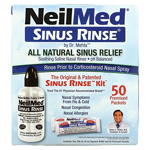
Use a sinus rinse! They can be picked up at pretty much any drug store/grocery store. Like a bidet for your sinuses. It will help with the inflammation/pain.
NeilMed Sinus Rinse - A Complete Sinus Nasal Rinse Kit https://www.amazon.com/dp/B000RDZFZ0/ref=cm_sw_r_cp_api_i_T0nxFbSGZ7MSR
These respirators are fairly cheap about $36 with filters
If your masks have filter pockets, try finding a PM2.5 to put in it, like these:
10pcs PM2.5 Activated Carbon Filter Mouth Mask Filters Breathing Insert Protective Mask Filter for Men Women,Anti Pollution Washable Cotton for Adults Outdoor Activities (10pcs) https://www.amazon.com/dp/B085L9HFV6/ref=cm_sw_r_cp_api_i_yXWvFbZE14DP9
Watch the documentary from the "home movies" they made on the bus, "Magic Trip," on Amazon or many other streaming services or buy the DVD: https://smile.amazon.com/Magic-Trip-Alex-Gibney/dp/B0058ZZHXC/ref=sr_1_1?keywords=magic+trip&qid=1566827094&s=instant-video&sr=1-1
Her mother wrote a book about her experience. Was just published last year, I'd suggest giving it a read:
Here you go, now you can wipe your tears anywhere you go! Any time a scary man with his scary inanimate objects makes you feel down, you can let those emotions take hold and cry it out.
https://www.amazon.com/Kleenex-Ultra-Anywhere-Facial-Tissues/dp/B06XD1FVNH
Thanks for the pic, it's one of my favorite places. I should go there more often since it's only a couple hours away.
If you want to get rid of the glare next time, get a big rubber lens hood for your camera. Press it up against the window to seal out any light that could reflect off the surface.
https://www.amazon.com/Collapsible-Rubber-MagicFiber-Microfiber-Cleaning/dp/B0094KJTWM
The lead exposure is an interesting angle I haven't thought of. I have been pretty sick of boomers' collective BS and ruining of our country and state for a while now. I recently read this book, which basically lays out the case that boomers are sociopaths only concerned with getting as much for themselves as possible. The author discusses how they were raised in ways totally different from previous and following generations and then uses mountains of data to ram home the point of how shitty they have been for the country. I have been recommending it to everyone I know that reads.
In the 1970s, the Santa Cruz city council voted to make Hwy 17 one way northbound in SC to keep the San Jose tourists out.
Source: a book on Hwy 17. I can't find online confirmation.
Well, this is sort of cheating - but since you have so little time you should consider this book.
> The concept of economic libertarianism depends on the notion that competition will always lead to the best winning out, but it ignores the fact that not everyone begins the race from the same starting line;
The philosophy does not ignore that. If you wish to learn about Laissez-faire economics I would start with this book http://www.amazon.com/Economics-One-Lesson-Shortest-Understand/dp/0517548232 It is an introductory book on the matter if only to help you better criticise it. I find that many on Reddit have a distorted cartoonist view of libertarianism, as if they learned about it from New York Times cartoons or something. I don't expect to convince more then three people of libertarianism in my lifetime, but would love to have more discussions about it with people who at least know what they are talking about.