
What are
/r/vancouvercycling's
favorite Products & Services?
From 3.5 billion Reddit comments
The most popular Products mentioned in /r/vancouvercycling:


The most popular Services mentioned in /r/vancouvercycling:
Ride With GPS
Strava
OpenStreetMap
Bikemap
Meetup
Weather Underground
Google Maps
AllTrails
The most popular reviews in /r/vancouvercycling:
I’ve done this many times. The 7 really isn’t that safe until you get to Bruce’s Corner. I would highly recommend union -> Barnet hwy -> Port Moody -> guilford -> skip busy Coquitlam -> old dewdney -> silverdale -> lougheed. Here’s a route: https://ridewithgps.com/routes/36689039
That gives you 2 minimal extra climbs (guildford in Coquitlam and dewdney hills up near mission) before the big lougheed hill mt woodside you would have to do anyways.
Personally, I would go one step further than that link I sent, and stay on dewdney all the way up over stave lake, then exit old dewdney directly after lougheed skipping all of mission, but it’s a extra hill (I recommend this because the section between silverdale and mission itself can get really busy as well and full of fast cars). Your water refuel stations then become the iron mountain store before stave lake, and the gas station right along lougheed outside of mission.
You can also do more lougheed at the start, but that adds more navigational complexity.
The south side of the Fraser is slightly longer with different scenery, but more convoluted. Google maps won’t be your friend because it doesn’t really know the nice roads, but there’s lots of twists and turns in there which is slower.
If you're going to be donating your knowledge, even if it's just of drinking fountains, I'd recommend openstreetmap instead of that enormous corporate entity, Google.
Openstreetmap uses a free licence, allows reuse, and remixing their database. One example is the bicycle oriented rendering they optionally display on their homepage.
It's really a great nonprofit, largely volunteer, project.
Oh, and lots of people who map on OSM are interested in bicycle related stuff. Bike lanes, bike routes, bike paths. And drinking water. Lots are already mapped, but I'm sure there are some missing.
Typical route GS takes for club rides is: https://ridewithgps.com/routes/35580040
Usually sub Railway for No.1 road in that route though. It's by no means a secret route, but is most peoples go to for road loops of Richmond.
Yes. This link was posted in another thread: https://www.env.gov.bc.ca/epd/bcairquality/data/station.html?id=E316370 You can see just one or two days were really bad this year.
If you want to go crazy a 3M half face respirator with P100 filters is $30 and $14 for filters = $44.
Avoid main roads whenever possible. Which you should be doing on a bike most of the time anyway.
https://www.wunderground.com/cat6/air-pollution-cars-affects-everyone-why-we-should-care
It's the gravel road with switchbacks the mountain bikers on Fromme use to get to their trails. But you just keep going you end up at Grouse.
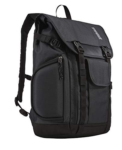
I managed to snag this while it was on sale a couple of months ago, it has served me well so far! https://www.amazon.ca/Thule-3203037-Subterra-Daypack-Dark-Shadow/dp/B0133APKFI/ref=pd\_lpo\_3?pd\_rd\_i=B0133APKFI&psc=1
I recommended photochromic sunglasses. They are great especially for those days where it is brighter in the morning/night.
I have a pair like this but there are tons of models.
Wow that looks amazing. I'm doing this or the Stanley Park loop depending on how much time I'm able to muster. If I can't do this one this time, I'll definitely do it next time, and take Arbutus Greenway back up to town. The ride I wish I could do: https://ridewithgps.com/routes/36971142
100th Ave (Strava) in Maple ridge is a good one if you are out that way (lots of great recently paved roads out there, so worth a ride regardless). The steep section averages a lovely ~19% for a bit under 100 m, topping out over 23%. Looks like fun.
Take a look at my response directly to tripleaardvark2, but in short, take a look at openstreetmap. They are a better choice for adding drinking fountains to. Partly because it's nice to to donate your time to big corporations, but if you don't care about that I'll point out that OpenStreetMap already has many fountains mapped, as you can see on their bike version, when zoomed in. If somebody wanted to do another version that allowed you to see drinking fountains when zoomed further out, then the could. They also have better mapping of bike paths and walking trails. Adding drinking fountains to a map that already supports cyclists and walkers is more likely to be useful.
As others have said, Richmond is your best bet. A map of the regular counter-clockwise route to Iona, around Richmond and coming back via River Road should be easy to find. If you start from Kits and go around UBC to start (basically, the Glotman Simpson club ride: https://ridewithgps.com/routes/35580040) it ends up being about 100km without too much elevation and plenty of places to stop along the way. And once you know it, it's very easy to navigate.
This route, in either forward or reverse direction:
https://ridewithgps.com/routes/29662518
Obviously can skip the north van loop :)
edit: and stay on dewdney if you don't want the extra hills
I couldn't tell you the names of the trails, b/c this was 2 years ago, but this is a fun route that we did that ended up at Lost Lake for a dip. https://www.strava.com/activities/68891371 --- And this is the second half of the day; https://www.strava.com/activities/68891370 --- I hope that helps.
A useful tool for planning routes is RideWithGPS. You can set up a free account and map out your routes, and it will show you the elevation profile of your route. That way, you can avoid those ball breakers.
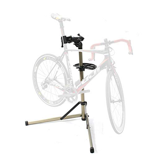
A bike repair stand also really helps as you can take the wheels off etc. but I understand that these can get pretty pricey. I have this one and I cannot recommend it enough.
Looks like a half decent cutter is $26 on amazon: https://www.amazon.ca/QKURT-Cutter-Bicycle-Shifter-Housing/dp/B08H4V9MPY/
I have cut cables with dremel/hacksaw/file/etc prior to getting a decent cutter and it works but is a pain in the ass. If you can't afford it PM me.
https://www.amazon.com/dp/B00BV6FQ8S/ref=cm_sw_r_cp_awdb_btf_t1_d5uGFbXVERCN9
I've honestly had these for over 8 years now and have changed the batteries twice. They OK for lighting your path, but great for visibility.
They are cheap, good, and last forever.
I have only seen them in Canada once at the Bike Doctor a few years ago (I bought them when I lived in the US).
I also have nice rechargeable lights. The are great for lighting things up, but after a a single season I needed to start charging them daily.
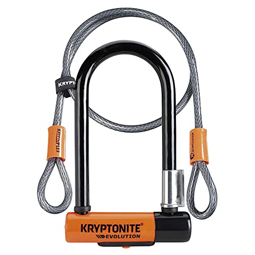
I have this Kryptonite Evolution 11-14mm U-Lock with FlexFrame-U Bracket, it is pretty small and struggle on THICC BOII bike racks or whenever I can't get RIIIIIGHT next to the metal I'm locking to. (If not using the cable..)
I had seen some friends with Kryptonite New York Standard Heavy Duty Bicycle U Lock Bike Lock and so I too wanted a small one. This one is a bit bigger and they have an easier time with it. I was just too cheap..
edit.. these definitely don't fit 2 bikes and we use them to lock all over the city when we stop for lunches or other things.. so different use case.. woops..
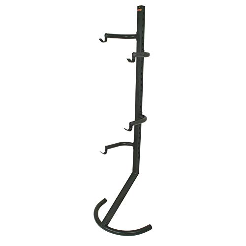
Best thing I did was getting one of those gravity bike stands. This allows you to stack your bikes one on top of each other to save space.
https://www.amazon.ca/Racor-Pro-PLB-2R-Two-Bike-Stand/dp/B000077CPK
Otherwise get more of those Brompton folders.