
What are
/r/Washington's
favorite Products & Services?
From 3.5 billion Reddit comments
The most popular Products mentioned in /r/Washington:


The most popular Services mentioned in /r/Washington:
AllTrails
TripAdvisor
Weather Underground
The Weather Channel
OpenStreetMap
Google Maps
500px
Coronavirus COVID-19 Global Cases
Windy
Figma
Flickr
Pastebin.com
Indeed
SimilarWeb
Gofile.io
The most popular Android Apps mentioned in /r/Washington:

PeakFinder AR

Scanner Radio
US Topo Maps Free
The most popular reviews in /r/Washington:
I'm not sure of the regulations but may I encourage you to use biodegradable ammo wherever you wind up? Leaving plastic pellets all over the place is more impactful than most people realize.
Kudos to you for asking about a place to do this responsibly btw :)
(ed: of, not if)
read this book then hike in to Monte Cristo
I use Scanner Radio on Android, you can set up push notifications when a scanner is above whatever number you specify of listeners.
Wow, their horrible, illegal gambit to privatize state funding loses in court so their natural reaction is "replace the judges".
Unbelievable.
Why do I get the feeling they've all got haircuts like this?
My suggestions (with links)
- Mount Storm King near Port Angeles. Gorgeous little town on the North end of ONP next to the ocean. Fairly cheap hotels and a good spot to load up on food for your hike.
- High Divide - Seven Lakes Basin near Forks - 19 mile trail that's got much less people on it than Mount Storm King. Definitely on the side of 'difficult' and will reward you with insane views at the top of the trail.
Bring good rain gear and warm clothes. https://weather.com/weather/monthly/l/WANPSOLMP:13:US Still enjoyable and lots to see even if its cloudy and/or rainy. Yurts available at Pacific beach might be good option if its really wet. https://www.reddit.com/r/Washington/comments/66x5sw/what_would_weather_be_like_at_my_rainier_in_midmay/
Crescent Lake has been one of my favorite places to camp since I was a kid. Beautiful, crystal clear bright blue lake and one of the best places in the country for star-gazing on a clear night!
Just added the restaurant to OSM using your website information. https://www.openstreetmap.org/way/232707040#map=18/48.51857/-122.61113&layers=N
Location is Reflection Lakes.
I took the picture on Labor Day weekend.
There's a couple on US 2 that I know of over near Sun Lakes: https://www.flickr.com/photos/tonyjcase/9474727289 - but it might be kind of a drive for you to make.
Sadly my favorite barn in that neck of the woods fell over a couple of years ago. Still the houses look pretty smooth.
Hole in the Wall - a beautiful 30-45 min walk down Realto beach to a large rock formation and then tide pools on the other side teaming with life. You can camp on the beach (mind you it will be nosy from the waves)
https://www.alltrails.com/trail/us/washington/hole-in-the-wall-trail
There might be hot springs? I vaguely remember some friends venturing out to hot springs one of the last camping trips I took out there, but sounded like they were not at all developed—lots of mud, some litter since they aren’t managed by anyone, as natural as a natural hot spring comes. IIRC, there was no parking and they had to hike in a bit. Good luck.
ETA: Google is your friend. Found this as the top result for “Mt Baker hot springs”: https://www.alltrails.com/trail/us/washington/baker-hot-springs
Go here and change the location from Seattle/Tacoma Airport to the area you're planning to be visit:
It's a little early for us but Montana is getting record early snow https://weather.com/forecast/regional/news/2019-09-25-september-blizzard-montana-northern-rockies-snow
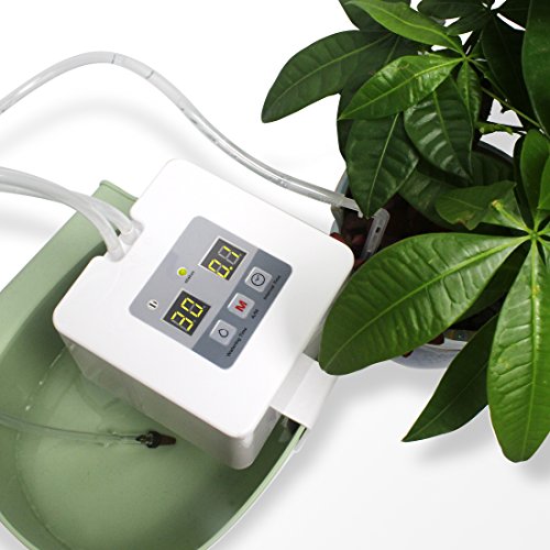
My Tomato plants are doing pretty well considering the 5 days of 100+ temperature's. The automated watering system gives them water every hour and only costs ~$30 on Amazon https://www.amazon.com/dp/B086BHHPR3?ref=ppx_pop_mob_ap_share
So before I shared the layer, I went back just to double-check that the topographic maps matched where the pins were on Google maps and sure enough it looks like there was an update from their satellite data overlay or their GPS positioning because every pin that I put in is off by about 10m to the northwest.
I can remake this layer but it will take some time and I probably will not have time to do it for a few days, but here is the general process in case you want to get started while you wait for my completion:
I use this app for Android, US Topo Maps
https://play.google.com/store/apps/details?id=com.atlogis.northamerica.free
The layer that I use is "US topo traditional drgs"
Centered roughly on the point: https://maps.google.com/maps?q=46.101834123,-122.220947742
view the map legend, the icons that appear like a slanted upside down "Y" indicate a cave entrance, they sort of look like this "ʎ"
drop a pin on one of those markers, share the location, copy the shared location into Google maps, place a pin in Google maps marking the cave entrance on satellite view.
There was a report that I read or maybe it was a website and it listed a huge variety of caves up there that were already known and named, let me do some digging later today or the next few days and update this with the name of the website or the report (I remember finding it and reading it sometime back between 2014 and 2017)
Check out this book. I go back to it over and over again. So many great topics. My favorite is Mel's Hole.
Weird Washington: Your Travel Guide to Washington's Local Legends and Best Kept Secrets (Volume 5) https://www.amazon.com/dp/1402745451/ref=cm_sw_r_cp_api_i_RY33P3J5YN0SWHWAK14E
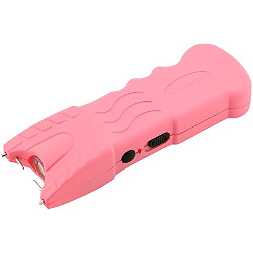
Thank you. This is the stun gun that I purchased from Amazon.
VIPERTEK VTS-979 - 59 Billion Stun Gun - Rechargeable with Safety Disable Pin LED Flashlight, Pink https://www.amazon.com/dp/B01FH3OFNW/ref=cm_sw_r_cp_api_i_BHAW5GG7X0RHJJFJRF06
I wasn’t sure it was a book or an 8 track tape under the dash: it’s a book: this person was into the space stuff!
Soviet Space Science : The Russian Story of Artificial Satellites https://www.amazon.com/dp/B000E4LOV6/ref=cm_sw_r_cp_api_i_KQ6JQEP5EYXP3RTGB5CW
Try Peakfinder I spend a lot of time in the mountains so I always have the "What mountain is that?" question & it can almost always answer it.
Switchbacks most the way up to the lake, about 4 miles, most people stop there, but I went through to Soughdough Gap so a total of 7.4 miles. Pretty steep hike, 2,913 ft elevation. Right now there’s pretty thick snow still up there about 1/3 of the way up, past the first campsite.
Personally, it was a bit challenging for me, haven’t really hiked in snow, I did all my hiking before I moved here in the southwest chihuahuan desert. I took all morning and afternoon out there 5-6 hours exploring and taking in the views.
If you’re interested in trail info & reviews about this hike and tons of other places to hime, get AllTrails! Hikers and reviewers rate crystal lakes about a moderate difficultly on AllTrails. Great app, I used it to find this trail and they are pretty updated regarding trailhead/road closures & directions if needed worldwide
https://www.alltrails.com/trail/us/washington/crystal-lakes-trail?p=23734331
The circle-what now? The circle-don't-kill-other-people-because-we're-not-socipaths-like-the-two-of-you? Fuck us, right?
Go get your hair cut or something, you beautiful sovereign citizen or whatever the hell is wrong with you.
Yessirree, sure wouldn't want to circle-jerk about not spreading a pandemic that's killed over 40 thousand Americans and 182 thousand humans world wide.
The Columbia Gorge is an often left out great place in Washington. Probably because it's mostly traveled on the Oregon side but the gorgeous vistas you're usually looking at are often on the Washington side. It makes sense that tripadvisor says the best thing to do in Portland is to travel along the river looking at Washington state.
FYI, they make stickers you can put on your windows to help birds see them more clearly, and they’re cheap + easy to apply. I got these a while back and haven’t had any collisions since: https://www.amazon.com/WINDOWALERT-WA-MAPLE-WindowAlert-Maple-Decals/dp/B001BO6EMC
> The cougar population is growing all the time, as is the wolf population.
Not really; not long-term anyway. The reality is that predator populations naturally fluctuate to stay in sync with prey populations. It's been studied enough that there's actually a term for it, the Predator-prey cycle.
I just recently moved to the Seattle area from out of state and hiking is my passion. I’ve found Moon’s Best Day Hikes in the PNW a great resource to find hikes and I cross compare latest reviews with WTA and All Trails https://www.amazon.com/dp/1640490744/ref=cm_sw_r_cp_awdb_imm_9YVRNRME45JM6JGCZMMZ
Happy Exploring!
Look up peak finder on what ever app store you use. It's on google, and it has been super worth it. It has like 98% of "ohh, I wonder what that mountain is?" Stuff on it. You can even go back to places virtually when you can use internet again. Works good for upper Puget sound. Rockd is another one
https://play.google.com/store/apps/details?id=org.peakfinder.area.alps
There is a book about Monte Cristo as well that talks about the town, the mines and it's history.
I like this book and you can probably find others in the library. its a good place to start. if you are close to spokane and want to hang with some mushroom wierdos, it looks like there is a spokane mushroom club. They can probably point you to resources closer to you if you arent from there.