
What are
/r/coloradohikers'
favorite Products & Services?
From 3.5 billion Reddit comments
The most popular Products mentioned in /r/coloradohikers:


The most popular Services mentioned in /r/coloradohikers:
AllTrails
Weather Underground
Strava
Meetup
AccuWeather
Have I been pwned?
WebMD
The Weather Channel
Airbnb
EveryTrail
The most popular Android Apps mentioned in /r/coloradohikers:
The most popular reviews in /r/coloradohikers:
Since your app collects geo data even when its not open and many apps are sharing location data with firms that market location data information without the users' knowledge as a way to monetize free apps. Can you tell me if you are selling users data? Also where is the data physically stored? The privacy policy states "The data processed at the owners offices and in any other places where the parties involved in the processing are located" especially since the address for the company is a UPS store P.O. box in Littleton, I doubt you are hosting servers there. All-in-all as a network engineer with background in security, you couldn't pay me to download this thing.
Edit* It is funny how many people blindly download stuff that tracks your every movement. LMAO
For those same people I have this link could you just run the java plugin when it prompts you. I swear it wont steal your banking credentials.
We’ve been going hiking almost every weekend. Before I get some hate post: No, I don’t care about 10-mile rules. We’re more careful about PPE and disinfectant and such than any person I’ve come across in the last two months.
Going anywhere north / north-west has been bad. One hike up in the Poudre Canyon was great, but other places we’ve gone have had crowds by 11am that fill up overflow parking and then some. PPE usage is like 10-20%.
We’ve had the best success in the Pine / Bailey area. There are some folks and most of them use either a face mask or very aggressive distancing (like 20 feet). Last weekend we did the first few miles of this trail linked below and it was one of my favorite hikes we’ve been on ever. There were some other people, mostly campers more than day-hikers. Seemed like plenty of spots to pick out and, as an out-and-back, you could go as far as you see fit. We did about 5.5 miles round trip. The parking lot was 80% full when we got there but it quickly splits into three trails so foot traffic is much lower.
If you're hiking from Devil's Playground, that makes way more sense. Just be warned, that is a brutal 3 miles. If you've never hiked above 10,000 feet, it definitely takes your breath away. That being said, it sounds like you've got a good plan and should be okay.
In addition to AllTrails there is an excellent free app for Colorado trails called COTREX (Colorado Trail Explorer). It's available on itunes and the google play store.
Emerald Lake in Rocky Mountain National Park is a good winter hike. It's popular enough that you won't need snowshoes unless there has been a recent storm. The trail will be packed snow and easy to follow. I've done it in a good pair of boots.
The last three days of November 2016 in RMNP varied between -4 and 5 degrees.
Not sure what elevation those temps were at, but, uh, good luck.
Chief Mtn at sunrise is my favorite hike. It’s pretty short and easy but has a steady incline. Need to be on the trailhead by 4:45am to make it for sunrise at 530. It’s a short hike - 3 miles out and back roughly.
https://www.alltrails.com/trail/us/colorado/chief-mountain-trail
Mount bierstadt is probably the easiest 14er if you’re trying to tackle one of those. Would still recommend getting there early. You want to be off of the mountain by noon.
Last July we could not do Four Pass Loop due to too much snow and avalanche debris. We did the Lost Creek Wilderness Loop in a calm 3 day hike. On the 3rd night we drove to the base of Mt. Sherman and climbed it on the 4th day. The Lost Creek Loop was beautiful with scenery more like Utah than Colorado. 28 Miles round trip.
https://www.alltrails.com/trail/us/colorado/lost-creek-wilderness-loop--2
Venable / Comanche trail in the Sangres might be a good option. Altitude reaches 12,700 and that area is fairly well-melted now. https://www.alltrails.com/explore/trail/us/colorado/venable-comanche-trail?ref=sidebar-static-map
https://www.alltrails.com/trail/us/colorado/chief-mountain-trail
Google says 53 minutes from denver. this is one of the closest hikes to blow people's minds that hasn't seen mountains in person before.
Here is the trail conditions for RMNP:
https://www.nps.gov/romo/planyourvisit/trail_conditions.htm
There are some nice trails around Estes with good views that arent part of RMNP as well:
https://www.alltrails.com/explore/us/colorado/estes-park
I suggest Pole Hill, Pinewood Lake, and the crosier mountain trails.
Not OP but this is on the Beaver Brook/Chavez trail loop near Chief Hosa and the buffalo herd on I-70
https://www.alltrails.com/trail/us/colorado/beaver-brook-chavez-trail-loop
I do this loop a couple times a year.
Two'fer where the same trail head goes to both Heart Lake/Rogers Pass and Creator Lakes
I just did Rogers Pass yesterday and it was amazing! Most likely what your looking for; you can hike in for five miles, camp next to Heart Lake, then the following day summit up to Rogers Pass where atop there are multiple other trails going to other passes and it looks/feels like your on top the world.
You can also simply just hike to and summit Rogers Pass to one of the many peaks in a single day; this is what i did yesterday but only with a day back/camal pack and hauled ass; did the 12 mile trek in 4.5 hours. Its an in and out hike (not loop).
Crater Lakes was really cool too. There are a bunch of lakes for fishing with some summit options but its lil more sketch then Rogers Pass.
Type in Moffat Tunnel in your google maps and you should be g2g.
Good luck!
pretty close! and its a two'fer where the same trail head goes to both Heart Lake/Rogers Pass and Creator Lakes
Type in Moffat Tunnel in google maps and it'll pull up; dog friendly too.
I agree with Buffalo Peaks. Just did that one this past weekend. Saw more cars parked then people for sure. Plenty of camping spots with existing fire rings, water available everywhere (filter required of course).
We parked here: https://goo.gl/maps/xyoCr6HnWiS2
https://www.alltrails.com/trail/us/colorado/buffalo-peaks-loop
So there is a really nice vista off of Chavez trail:
https://www.alltrails.com/explore/trail/us/colorado/beaver-brook-chavez-trail-loop
If you take the eastern most part of the loop, after the vista it does down quickly.
You can also do Pavilion Point, it's very pretty and easy and usually not busy:
https://www.alltrails.com/trail/us/colorado/pavilion-point
You could also drive up Guenella pass and do a few hikes to the glacial lakes there, similar to mount Evans but I think it has easier hikes on it.
It's a piece of paracord with beads on it. As you go you slide a bead down (for each piece of trash) there are different sections to mean different amounts.
Skip to 1:39 and don't worry about the pace/kilometer part. I'd probably make my own, one section to mean 1-10, and a second section that means every 10, 20, 30, 40, etc. It's hard to explain. You could also use one of those cheap people counting tickers from Amazon if you're not a diy-er
https://www.amazon.com/dp/B075QFK6DG/ref=cm_sw_r_cp_apa_glt_fabc_4ZRC96QF3FM2YQE0PZ8W
> Guanella Pass Road closes on the Georgetown/I-70 side at 0.8 miles from the summit and Bierstadt Trailhead. For the Park County/Hwy 285 side of the pass, the road is closed 6 miles down from the summit/Bierstadt Trailhead.
So it's partially open, but I'm not sure if Abyss Lake is more than 6 miles from the summit. I doubt it, but someone posted a trip report on 12/24/20, which makes me think it's possible.
Know the signs and symptoms of altitude sickness. If you're coming from a lower elevation, anything over 8k is going to put you at risk (even moreso hiking) and it mimics some scary things while being dangerous itself.
That being said, do Rocky Mountain National Park. It's a bit out of the way but it's such a beautiful place that it convinced me to move to Colorado in the first place. Loch Vale would be a pretty easy hike that's stunning, and if you're an experienced hiker going to Skypond or Black Lake beyond it is a perfect introduction to the Rockies.
Did this loop a few weeks ago and although conditions weren't great due to wildfire I had a rad time. I'd also recommend checking out anything in the Collegiate Peaks if you're really wanting to get after it.
In Nederland off Moffat Tunnel East, Rogers Pass Lake is fairly difficult in terms of length/altitude but you're right below the continental divide and it's stunning. The divide itself is where the hike becomes strenuous.
> easy-moderate
https://www.alltrails.com/trail/us/colorado/sky-pond-via-glacier-gorge-trail
Sky Pond itself is more on the harder side of moderate, but that area is my favourite in the state. There are two easy lakes branching off of it, Mills and Loch Vale, which are stunningly beautiful. If you want to test yourself physically and see where you are at in terms of hiking ability, going past Loch Vale to Sky Pond will give you an interesting scramble and some rock walking with two more amazing lakes.
You'll want to start early with that one. Parking fills up fast and the national parks are on a reservation system right now after they open. I arrive by 4AM, start about 1-1.5 hours before sunrise, and try to be at Mills or Loch Vale by sunrise. The elk begin feeding around that time and you're more or less alone on the trail, and you'll be down by noon when thunderstorms begin threatening the lakes.
Check out this trail on AllTrails. https://www.alltrails.com/trail/us/colorado/greater-venable-comanche-loop
This is one of my hikes in CO. This is a link to the loop, it’s much easier if you just do an out and back to one of the lakes but still a challenge. Browns Creek I think is another one I like it has a waterfall and a lake too.
I'd recommend downloading AllTrails, choosing an area in the front range, sorting by "Popularity", and choosing something that matches your fitness level.
Edit: In terms of gear I'd recommend a basic backpack that can hold a few extra pieces of clothing based on forecasted conditions, some snacks and lunch, as well as plenty of water and a small first aid kit.
- Download the app and check reviews on whatever trail you’re looking to do. If a road is iffy people will often leave a note so you know what you’re in for.
https://www.14ers.com/php14ers/trailheads_bydifficulty.php
-Here’s a list of the trailheads for 14ers by road difficulty. There’s no way you’ll get a Prius to G&T’s 4WD trailhead. You can park further down at the 2WD parking lot though
Did part of the Goose Creek Trail which connects with Mccurdy trail for a great backpacking loop last weekend. I thought it was fantastic and I'm biased towards peak hikes. A ton of great camp sites along the trail.
In a Forester you'll have no problem going up Montezuma road, so I'd also suggest looking in the Dillon Lake area. A good trail that I know of is the Santa Fe Peak trail, and I'd also suggest the Peru Creek trail as well.
Drive slow in Montezuma or the locals will harass you. You've been warned.
How wild do you want it? If you have snowshoes/microspikes you should be able to hit up a lot of stuff. I think that the vehicle you're in will determine quite a bit of what's available.
This will get you started in the Minturn area.. I'm also a big fan of hoosier pass.
Conditions are pretty localized, especially this year, so ask around. The visitor info centers in each of the towns and the national forest visitor info centers can help fill you in on the conditions on the ground in the area.
I can't speak to any 14ers as I haven't done one yet this year. For your less experienced hikers, however, I hiked Panorama Trail to Bear Creek Trail about two weeks ago and it was completely clear and dry. It'd be a great one for folks who have never hiked or aren't in as great of shape to do (it's still got a decent amount of uphill to get your heart pumping though) and has a great view at the top. https://www.alltrails.com/trail/us/colorado/panorama-point-to-bear-creek-trail-loop
Seconding the recommendation for either snowshoes or microspikes (Estes Park Mountain shop rents both). Microspikes are my preference but snowshoes are good if you are breaking new trail.
Deer Mountain would be a beautiful hike in the morning. Dream Lake is the classic RMNP hike. Sprague Lake also has some nice views.
Don't get discouraged about the cold spring weather, if you are prepared for it you can really enjoy yourself. You'll start off cold when you get going but you'll want to shed layers as you get heated up. For me, that can look like: softshell, down vest, flannel shirt or just a puffy. Lightweight hat and gloves are always good. The sun is pretty intense at altitude so definitely wear sunscreen and don't forget your sunglasses!
Just got home. Rains in the afternoon. mid forties at night. Very pleasant.
Don't rush the loop. Lots of places to explore, campsites to find, and secrets too ;) We'll be up there again in a week as well.
Yep that's about it. https://www.alltrails.com/explore/recording/custom--21. Just turned it into loop and left my soul somewhere on Bierstadt trail. It was deep and cold and nightfalling as we approached the downhill back to Bear Lake Rd
https://www.alltrails.com/trail/us/colorado/big-dominguez-canyon
Big Dominguez canyon. Not a loop but did it last memorial weekend and saw literally 10 people all weekend. Made it a two nighter and camped by the waterfall the second night. Lots to see.
Sites like Alltrails and the Hiking Project will give current conditions. Alltrails indicates you'll probably want spikes.
I second this. I have taken so many new hikers to Chief mountain and everyone loved it. Incredible 360 degree views for a short time.
Check out this trail on AllTrails. https://www.alltrails.com/trail/us/colorado/chief-mountain-trail
It is possible, but, you must be prepared. here is a trip report describing the effort. I've also heard there is avalanche danger.
As far as gaining some nice views, RMNP has some great trails that are well traveled in the winter. Emerald Lake, Flat top Mtn, The Loch, Mills and Black Lake. You can walk/ski up Trail Ridge RD in the winter, but I would recommend the aforementioned hikes over that. You can rent snow shoes and other gear at the Estes Mountain Shop on the way in to town
I'm gonna throw Ultima into this mix! We've tried a lot of different ones over the years and prefer it to Nuun and everything else so far. Low sugar, good flavors, comes in small single-use packets for hiking/running or bigger canisters for home.
For the boots, I use Salomon Mid GTX: https://www.amazon.com/Salomon-Womens-weather-morning-Bluebird/dp/B07V486JFQ/ref=mp_s_a_1_5?adgrpid=116674559900&dchild=1&gclid=Cj0KCQjwyN-DBhCDARIsAFOELTnMRH4Es7NuJ5r63ZVzim0De-mksZfCEyMex7r2HNWHNbAixyg3wucaAiRgEALw_wcB&hvadid=4894175...
I'm very picky on my hiking boots, and for me, these ones hit all the key criteria. Lightweight, waterproof, ankle support, good grip, and not insanely expensive. Try them out!
Amazon carries a whole range of Anker chargers. In picking one you balance the size/weight with the number of charges a charger offers to suit your needs. (A charger that holds more charges will be heavier). This is similar to the one I carry most. It is at the bigger/heavier end of what most need for hiking and backpacking. https://www.amazon.com/dp/B00X5RV14Y/ref=cm_sw_r_sms_c_api_DmjzAb5VAF4HN
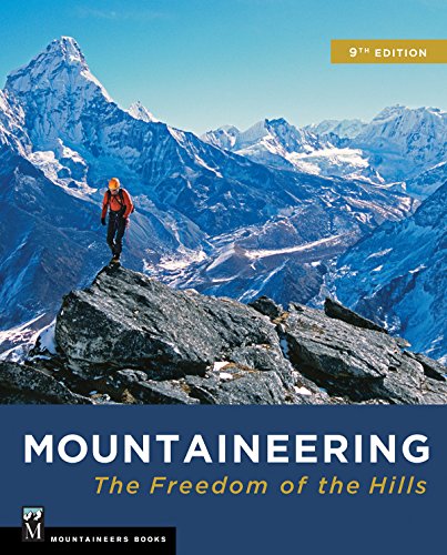
Pick up a copy of this book: https://www.amazon.com/Complete-Guide-Colorados-Wilderness-Areas/dp/1565795164#ace-g2342880709
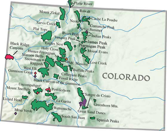
Opportunities abound. Flat Tops Wilderness and Weminuche Wilderness are both very large and have many loop opportunities.
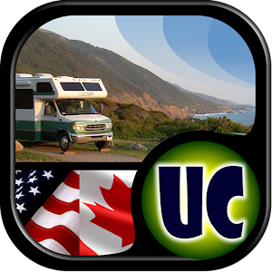
I just recently finished with a 3500-mile road trip, and sought out dispersed camping along the way. I used an app on my Android to pinpoint locations... Maybe it might come in handy for you too: Ultimate US Public Campgrounds
Just get the cheap "Ice Cleats" off Amazon they work excellent!
Nice score! I just stay at my friend's house, so no suggestions. Estes has lots of accommodations - cabins, motels, plus airbnb/private rentals are strong up there: https://www.airbnb.com/stay/rocky-mountain-national-park
Also, the Stanley if you're a fan of The Shining: http://www.stanleyhotel.com (be warned - the pictures on the website make it look isolated, but it sits just above main street... there's a Safeway hidden behind those trees!)
Thanks for the suggestions - appreciate it ! (With due apologies for my ignorance). I just wanted to clarify the trails that might be accessible from the locations you listed:
> Brainard
Is that the Lake Isabelle via Pawnee Pass Trail?
> Hessie
...Lost Lake via Hessie Trail?
> East Portal of Moffatt tunnel
What trailheads are accessible (via plowed roads) from here... ?
Got to do this trail while I was in town last week, some beautiful views! https://www.alltrails.com/trail/us/colorado/middle-columbine-trail--2
This trail can be short of you need a quick hike or you can keep following for a much longer day if that’s suits you better!
Get microspikes. I have these, they are inexpensive and effective.
https://www.amazon.com/dp/B07VK27PGH?
I moved here from OK and love it. If you're in the Springs I recommend the 7 Bridges hike.
100% chance of heavy crowds and traffic jams.
Weather is too variable to forecast but here's some historical data:
https://www.wunderground.com/history/weekly/us/co/loveland/KFNL/date/2020-5-30
You can probably carefully bend it back in shape and use a fiberglass wrap like this to reinforce it.
FiberWeld Permanent Repair Cast 2x36 Inch - High Strength Adhesive Fiberglass Wrap - Black, 38236 https://smile.amazon.com/dp/B08B3MKWH9/ref=cm_sw_r_apan_i_EBDC5WA4F85K7PZGSX26?_encoding=UTF8&psc=1
Just did Emerald Lake this week. You’ll be fine and have a great time if you buy something like this for $25 or so. They work incredibly well.
Wunderground shows the chance of rain at the park beginning to rise around 10AM. Being higher up than whatever weather station they're using, you're in those clouds and it's way less predictable when they'll be active. On the way to Chasm Lake before the boulder field turnoff, you have about a solid mile or two where you are above the treeline and that's still at the base of Longs.
Tomorrow looks similar and I cancelled a morning photography project at 10.6k because even at the treeline I've been caught in storms up there and it's terrifying. Knowing I'm the lightning rod makes me try to move fast and stupid. At most I've been given like 15 minutes of warning, a single stray cloud usually, and both tomorrow and Tuesday that cloud cover is going to be thick and menacing because it's between two storms.
Berthoud Pass has great hikes off the switchbacks. Look for open parking areas on the shoulder and follow the trails out from there. There are three different cabins that are relatively easy hikes from the road. https://www.alltrails.com/trail/us/colorado/first-creek-cabin is one of them. Looks like All Trails has a really good list of the trails in the valley.
I've never done this one, but have considered taking parents on this before if you're ok with going a little further than Breckenridge: https://www.alltrails.com/trail/us/colorado/narrow-gauge-trail-1432.
Devils Thumb Pass in IPW if you can snag a permit.
Also if check out this loop just outside RMNP.
Chief Mtn at sunrise is my favorite hike. It’s pretty short and easy but has a steady incline. Need to be on the trailhead by 4:45am to make it for sunrise at 530
https://www.alltrails.com/trail/us/colorado/chief-mountain-trail
I'd highly recommend downloading and paying for a premium subscription to AllTrails. It's got the ability to sort hikes by certain area, distance, difficulty, etc.
Since you're starting off you really can't go wrong by searching based on popularity, looking at photos sorted by new (to make sure snow isn't an issue) on an individual hike, and going from there.
At that point you can bookmark a few hikes and if using the app click driving directions to have it open right up within Google Maps.
If you purchase a premium account you can then download the maps themselves for offline use. This just gives you the added confidence and info you'll need to navigate any tricky trail systems. Heck you can even open up a downloaded hike and "record" your progress as well to better get an idea of difficulty, making sure you're on the right trail, etc.
Pretty much using the app roughly goes like this:
- Find an individual hike prior and download the map layers for offline use
- Hop in the car, pull the hike up and boot up driving directions
- Once starting the hike "record" the hike and also "load" that downloaded map to know where you're at.
My friends and I did a very fun loop in Indian Peaks. We did 3 nights/4 days midweek. Saw less than 20 people until the last day (Saturday).
Day 1: Hesse Trail head -> Devils Thumb Bypass -> Diamond Lake Trail -> Camp at Diamond Lake
Day 2: Diamond Lake -> Arapahoe Pass Trail -> Over Arapahoe Pass -> Camp along Arapahoe Creek
Day 3: Camp -> High Lonesome/CDT -> Camp just pass Devils Thumb Trail at Cabin Creek
Day 4: Camp -> CDT -> King Lake Trail -> Hesse
We were going to camp at King Lake, but it was super windy and exposed. The best camp was Diamond lake, and the worst camp was along Arapahoe Creek. I would camp at Monarch lake if I were to do it again. The biggest issue with IPW is the lack of trails North to South (or vice versa), so it makes loops slightly difficult.
This book is a great resource for peak bagging, and you could definitely use it to create some loops.
Let me know if you have any questions!
To this lake it's only 5.4 round trip! There are two other, IMO prettier lakes up higher (Lake of Glass and Sky Pond) but they bring the total up to over 8 miles and elevation gain up a good bit. You will also pass Alberta Falls on the way :)
The Loch Lake Trail via Glacier Gorge Trail Check out this trail on AllTrails. https://www.alltrails.com/trail/us/colorado/the-loch-lake-trail-via-glacier-gorge-trail
Try the Ute trail in RMNP, but stop about 2 miles in before the trail plunges into the valley. The first 2 miles is a mostly steady walk at 11,500' that allows you to experience high elevation without climbing up to it. This is one of the first hikes I did after moving here from sea level and found it a great bang for the buck.
Sounds like an awesome trip, I'm jealous. Dunno what parts of Colorado you're gonna be in but Maroon Bells is a classic. Been there a couple times and always see a lot of dogs. Definitely stop by if you're in the area, though I've heard they're going to make people have reservations this year to go there due to COVID.
Krueger Rock Trail and St Vrain Mtn Trail
https://www.alltrails.com/trail/us/colorado/kruger-rock-trail
https://www.alltrails.com/trail/us/colorado/saint-vrain-mountain-trail
I would call the park rangers for this district too, and see what they recommend. They’ll know the conditions, what’s open and what’s not, and be able to give you some tips.
This is my favorite up there but it's long, strenuous, and likely still snowy in spots. You could totally do an out-and-back in the camp lakes area.
I actually live in the area too. I have been looking for dispersed camping sites, and just found a place west of Cheyenne that looks promising, Vedauwoo. It looks like the campground is closed until June, but I think dispersed camping is still available in the area. Sadly, there’s not a lot of info online though so I’m still doing a lot of digging.
EDIT:
Check out this trail on AllTrails. https://www.alltrails.com/trail/us/wyoming/turtle-rock-phallic-trail-valley-mastif-regolith-skeleton-trail-loop
Here’s an 11ish mile loop that I bet connects to other trails too. I’m probably going to do some camping in that area in the next week or 2 so I can let you know if it’s worth it.
These are arguably the two best summits I've done all winter if you enjoy a little bit of isolation. Check out this trail on AllTrails.
https://www.alltrails.com/trail/us/colorado/tanglewood-trail This trail had a super nice packed trench and I didn't need my snowshoes at all. Obviously that could change any second if we get a bunch of snow. The trail itself leads to the Roosevelt Lakes in the basin of Mt Rosalie and Mt Evans, but you can also turn up the ridge from the saddle between Pegmatite Points and Rosalie and summit Rosalie for the gorgeous summit views of nearby Evans and Bierstadt as well as a good view of the Sawatch range. (I went a little further and did Epaulie and Epaulet which had some class 2 scrambles to summit)
https://www.alltrails.com/trail/us/colorado/south-boulder-peak-trail?p=-1 This hike starts out really chill crossing about 3 miles of low elevation then climbs straight up to the top of the saddle between South Boulder and Bear Peak, the views are spectacular since the flat irons are very prominent for ~8500ft in CO. I summited both peaks and hiked down via Fern Canyon to make it a loop. The trails remain open despite nesting raptors in the area and the views are spectacular and the hike itself is a nice challenge. Def need spikes as Shadow Canyon especially gets icy.
Also Twin Sisters in RMNP is a really gorgeous hike but depending on the day is often super busy so you don't get that isolated feeling but you can almost guarantee a packed trench due to high traffic and beautiful views of Mt Long and the Mummy range to the north.
The Parmalee Trail Loop in Mt Falcon Park is a good and relatively short trail (only 3mi). There are plenty of other connecting trails too in the park for you to make it longer.
https://www.alltrails.com/trail/us/colorado/parmalee-trail-loop?p=24974558
The beaver brook trail off windy saddle has a really remote feel (and you can go 9 miles out).
https://www.alltrails.com/trail/us/colorado/beaver-brook-trail
I'd recommend traction or poles for the current conditions.
Check www.alltrails.com for recent reports of trails. I think Sky Pond is doable if you are experience with snow shoes and micro spikes this time of year. Sometimes you can get by with less if the trial is packed, but I wouldn't count on it with this recent storm. I know some folks made it up to the Loch, but ended up turning back after that.
I'm taking a look at the area, and fuck Alltrails for restricting so much of their map function behind registration, but this Rogers Pass Lake seems to be the closest trail they feature assuming it starts from Moffat Tunnel. In any case, any of the trails which do start there and end at that lake will put you on the trail to Iceburg Lakes. It's just a straight shot up the Continental Divide and take a right.
Have you looked into going in from the North Rim at all? There is camping up there as well as access down the draws to the river. It's not easy, not by a long shot (hell, one of the draws is called the S.O.B. Draw), but the rangers on the north side can help (and give you permits for that route).
Another option that might be more suitable for a multi-day stay after a hike is Hermit's Rest Trail nearby: https://www.alltrails.com/trail/us/colorado/hermits-rest-trail
By the way, I did see this link that might prove helpful as far as pictures of the Gunnison Route: https://www.thevanimals.com/advanture/hiking-the-Gunnison-Route
Would you suggest the NCAR and Mesa trail or just the NCAR hike? NCAR is a little over 5 and adding Mesa trail puts it just under 10 miles. Check out this trail on AllTrails. https://www.alltrails.com/trail/us/colorado/bear-peak-west-ridge-via-ncar-and-mesa-trails?p=23002906
If you can hike Bear Peak, you can start hiking 14ers. I suggest parking at NCAR and attempting a solid hike. If you get there and change your mind, there are lots of trails weaving around and it is just a little drive for you north on 93.
Yes - Trail Ridge Road is a beautiful drive! The Emerald Lake hike (on the other side of the park) is short and has big visual payoff. Plus, there are three lakes along the trail and you can turn around at any time. Ouzel Falls is another easy and beautiful option, but is slightly longer.
Check out Zirkel Circle in Clark. 10.3 mile loop with about 2400 elevation gain. I've done this several times as a day hike and would love to do an overnight sometime. Gilpin lake is so beautiful. Lots of Aspen groves that will be starting to change. It's one of my favorite hikes.
https://www.alltrails.com/trail/us/colorado/mount-zirkel-loop-trail
Hit up Strawberry Park hot springs when you're finished! They don't take credit cards, cash or check only. Best place to soak for sure.
Here are two of my favorites that I think would be great at that time:
St Vrain creek is mostly sheltered, so even if the temps are cold you’re be out of the wind and warm up quickly. It’s out and back, so you can make whatever distance you want: https://www.alltrails.com/trail/us/colorado/ceran-saint-vrain-trail?p=23870471
Mount Galbraith is really close to Denver and has some great views. It’s very open, so if the sun is beating or the wind is blowing, there light be better options. I last did this with friends as a night hike under a full moon (in the snow) and it was amazing. There was so much light we didn’t need our headlamps. https://www.alltrails.com/trail/us/colorado/mount-galbraith-loop-via-cedar-gulch-trail?p=23971251
Bierstadt is really easy. As a first one you'll huff and puff a little but if you hike often it should be fairly easy and straightforward. You can always do torreys and grays another weekend this month. I've done 5 of them and Bierstadt was by far the easiest one so far. It felt just like a normal hike to me. If it wasn't for my coworker I could have summited it in 2 hours and been down in 1-1.5 hours. G&T is a big thigh burner with a lot of switch backs going up grays and then when heading over to Torreys you wish it was over. I'd personally get Bierstadt out of the way since it's so easy and such a popular one. It's packed full of people. Get there early that way when you're coming down you'll only encounter the lines and they'll move out of your way. Just under Bierstadt's summit is a small section of scrambling.
Fun fact if you're really wanting to do 2 for 1 you can do Bierstadt and Evan's together. Which is typically how it's done when doing Evan's. Take the sawtooth combo route over to Evan's. I would actually reccomend this if you want a more challenge to your first one, and it's totally doable as your first too. https://www.14ers.com/routelist.php?peak=Evans+and+Bierstadt
https://www.alltrails.com/trail/us/colorado/mount-bierstadt-the-sawtooth-and-mount-evans-loop
https://www.alltrails.com/explore/trail/us/colorado/big-meadow-and-ptarmigan-pass-loop-trail
I think this is your one. You can checkout the route and see how you can extend the trip if you want more miles. It looks like theres a mountain you could summit along the way for example.
Go easy your first time so you can feel it out.
Oh great reply. instead of actually answering my question and targeting the subject at hand you've done nothing but result to insults in all of your replies including your initial one.
Oh hey everyone can anyone tell me how alltrails algorithmically calculates all of it's ratings? Because since we all are hikers on here we are all probably also developers with high level knowledge of how alltrails has programictically employed their technology to calculate rankings.
That is the stupid question you are trying to ask.
Or maybe with a little effort from your ignorant lazy ass you can look up the support articles provided on alltrails and find out some basic info for yourself.
> Make whatever edits you think are needed to improve the accuracy of the trail (trail name, trailhead location, length, difficulty level, whether dogs are permitted, etc. You can also suggest a better verified route and draw that route by clicking on 'Draw Route' under "Step 1- Suggest a better route" in the top left hand corner
https://www.alltrails.com/trail/us/colorado/grays-and-torreys-peak/edit?ref=trail-suggest-edit
OH LOOK! By clicking on that link you can EDIT the actual trail Difficulty rating by suggesting an edit to the alltrails staff. WHO WOULD HAVE THUNK IT? Maybe, just maybe... after you submit that edit the staff reviews it and compares their notes to other things to prove that edit might be correct. Or maybe, just maybe... like google does... it uses an algorithm that they only know the answer to that helps them verify the massive amount of edits that come in from user submitted info. so they can clear the backlog of edits and get them published.
But you guess what the fucking common denominator in this whole guessing game is?! ONLY THEY KNOW.
Sighting was reported here: https://www.alltrails.com/explore/trail/us/colorado/west-branch-trail on June 8th, 3rd review down.
I'm only there for 2 days, 1 night. A Sunday and Monday trip. I might decide to stay a 2nd night but have a long drive home on Wednesday (12 hours). I'm in FoCo for a couple days before that for other business.
The Griffin memorial hike out of Silver Plume is great if you want to see a little bit of everything. Old mines, scenic views, etc..
It's overlooked by a ton of people, but I take friends and family there all of the time and they absolutely love it.
Most trails are going to be pretty tame during the week.
That said, hit up Mount Morrison behind Red Rocks. It's close to Denver, beautiful, and just a crazy calf burner. Go to Red Rocks entrance 4 right outside of Morrison and park right there. You'll see a trail that basically looks like it goes straight up (because it does).
It's such a workout that anybody else you see there will also be sweating their clothes off, so nothing to feel self conscious about.
https://www.alltrails.com/trail/us/colorado/mount-morrison-south-ridge-trail
Last year with less snowfall, June was still snowy above like 9k. I remember trying to do the B-17 hike and having to turn back because with the forested areas snow was still like 1m deep and too unstable for anything but snowshoes.
This year I'm not even going to bother trying to do Colorado hikes in June unless it's in the more arid regions. That's when I'm planning to go to Washington because they're low enough to be in wildflower season. Anywhere mountainous in Colorado is going to be too snowy or muddy to be an enjoyable summer hike.
My first recommendations would be the Fowler or Rattlesnake trails in Eldorado Canyon State Park. Excellent views of the front range, the Arapahoe range, and why we call this the "front range". You also get some great history of the area.
- Gregory Canyon
- Mesa trail between NCAR and Chautauqua park
- Mt. Sanitas (strenuous)
- Eagle-Sage Lollipop
- Betasso Loop
Relevant AllTrails
Not a very long hike, but there is a trail around Lower Cataract Lake that is nice. https://www.alltrails.com/trail/us/colorado/lower-cataract-loop-trail . There is a nice little cascade around the back side. I hiked from there up to Surprise Lake in early June many years ago and it was clear up to there. Not sure with higher than average snowpack this year.
Sounds like you are interested in Lost Creek Wilderness Loop. Check it out
​
1st week in June will most likely be too early for a true alpine wilderness experience this year. I would love to get out early too, but experience has taught me that 3rd week in June is usually as early as you can get into the high alpine areas. This year so far is at or above snowpack for most areas. Check out Snotel for snow depth in that area as it gets closer to June. Right now Lake Irene at 10500 ft in RMNP is posting 84 inches of snow on the ground.
Yeah I’m not sure about the road... AllTrails says you take a dirt road a quarter mile to the trailhead. I don’t mind hiking up the road, but do you know if the roads leading up to the dirt road would cause issues or are they cleared?
It's 7.5 from the Grays TH, up Kelso Ridge to Torreys, across to Grays, and down the Grays standard route. This is the Strava page for the route: https://www.strava.com/segments/7763776?filter=overall. I've done it a few times and my GPS watch gives between 7.2 and 7.5 miles. The 14ers route page says 6.75, though.
I can't speak to the Solomons, but my one and only pair of hiking boots are the Zodiac Plus GTX that I got at the REI garage sale 5 years ago, and they're fan-fucking-tastic.
I did find out that I have really high arches, so I got some fitted insoles for them last year and they feel like new shoes entirely! https://www.amazon.com/Keen-Utility-K-30-Insole-10-5/dp/B01MZ67LVR/
The toe box is quite stiff; I've never felt uncomfortable even on steep scrambles.
Greyrock up by Fort Collins is a good one... Make a day out of it and then stay before you head to Steamboat or further in the mountains...... If I were you after the early morning hike I'd hit up the breweries (Odell and New Belgium) get something to eat from Blind Pig or Choice City Butcher/Deli and hit the hay after. Solarium Hostel is cheap and fun spot to rest your head for the night.....
​
(they say Greyrock is good training ground for 14ers......) It's relatively quite this time of year. It won't be too crowded and isn't hard to get to. https://www.alltrails.com/trail/us/colorado/greyrock-trail
Lake Isabelle meets all of your criteria and is an amazing hike. The "lake" is a reservoir and gets partially drained in the fall, but don't let that detract you. Parking is tight, so go early. Blue Lake is a similar hike and leaves from an adjacent trail head at Brainard Lake Recreation area.
I have only been here at sunset but I think sunrise should be good too. Lily mountain. 360 degree views, Estes park on one side and rocky mountain on the other. https://www.alltrails.com/trail/us/colorado/lily-mountain-trail
No problem, depending upon how fit you are, another really awesome trail is Griffin Memorial out of Silverplum, it's pretty hard but filled with mining artifacts and an awesome vista. I do this trail after work sometimes.
https://www.alltrails.com/trail/us/colorado/griffin-memorial
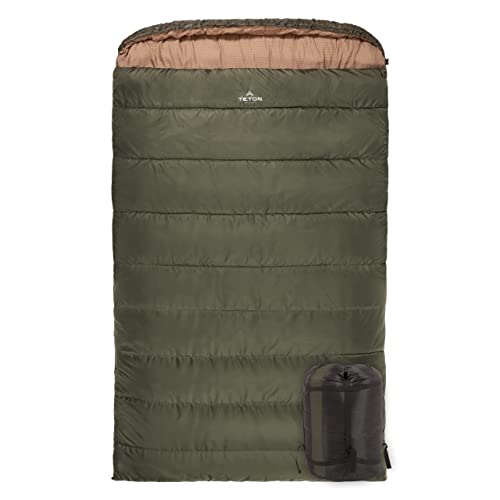
It's always cold in the mountains at night, usually in the 40s. For backpacking I have a 15° bag with a winter pad. For car camping we have this monster.
Some easy trails are Staunton State Park and Mount Falcon. You should have an easy time getting to either by car. Roxborough State Park isn't in the mountains, but it's beautiful and you wouldn't have any driving concerns whatsoever. There are tons more, just use the AllTrails app and look at recent reviews to get an idea about trail conditions. The only specialized gear I recommend are hiking shoes and microspikes. Don't skimp - the spikes are crucial and will make your hike 100 times more enjoyable because you won't be afraid of slipping the whole time. My favorite are the Ice Trekker Diamond Grips; you can pick some up at REI in Denver and have a great hike.
https://www.amazon.com/dp/B00A3T8Z6O/ref=cm_sw_r_cp_apa_fabc_z8pYFbAFSS6C4
what zones do you have permits for? some have higher bear activity than others.
I'd also recommend an ursack + an odor proof bag
I use this one and highly recommend it.
What kinda vehicle do you have? Tons of forest service roads in the area offer ample opportunities for dispersed camping.. but if your in a low clearance vehicle you needa careful and bring good maps because you wont have cellular signal.
Thank you so much. Thank you taking your time to explain it to me.
I have this Sawyer. I think we might have drank some water from one of the lakes in Titans but we survived that without getting sick. We also mostly boiled it as it was really cold outside(October).
I'm definitely going to get the tablets for treating. It sounds it's good to have them in your pack.
Lastly, which USGS maps do you use? I just went to their website and I am kinda lost. I have been buying the National Geographic maps where ever I go. Are those good enough? Would they show mining sites?
Thanks again. I really appreciate you typing all of this. It's super helpful.
I have the Ice Trekkers.
http://www.amazon.com/ICETrekkers-Diamond-Grip-Traction-Cleats/dp/B00BEQKM7K?th=1&psc=1
They work very well in icy conditions, and I've yet to break a pair. In the winter I can make it up the first Flatiron faster than in the summer.
As one would expect, they're not great on solid rock (like rubber shoes are). It actually becomes easier to stick to the ice. They work well in hard pack snow, but they're obviously not snow shoes, and won't work in the deep stuff. Absolutely worth having a pair.
Buy one size up for boots. I'm a 10.5, and the large fits all my shoes better than the medium.
Also, at the Boulder REI garage sale they sometimes have some at a discount.
Similarly most Colorado wilderness area trail heads expect people to pack in overnight and leave their cars at the TH. A great resource for hiking and camping is the Complete Guide to Colorado's Wilderness Areas
Absolutely! Maybe pick up a copy of this or similar. Trail Damage also has a lot of great info. Keep in mind that high altitude trails will not be open until mid to late June or even July in some cases. Southwest Colorado (Ridgeway, Ouray, Silverton, Lake City, Telluride) is one of the biggest areas for off roading and some of the most beautiful scenery in all of Colorado. If you are on the front range maybe check out Rollins Pass West (Near Nederland) or there is a 4WD trail starting at Camp Dick that goes up a few miles to the TH for St. Vrain Glacier Trail (Near Ward)