
What are
/r/wmnf's
favorite Products & Services?
From 3.5 billion Reddit comments
The most popular Products mentioned in /r/wmnf:


The most popular Services mentioned in /r/wmnf:
AllTrails
MetaFilter
WordPress
Wayback Machine
The Weather Channel
Weather Underground
SurveyMonkey
Dark Sky
The most popular reviews in /r/wmnf:
Do the whole skyline trail in the blue hills? It’s about 15 miles. It’s not crazy challenging in terms of elevation but still fun.
Edit: distance and also I lied if you do the whole thing the elevation gain is ~3400 ft.
Check out this trail on AllTrails. https://www.alltrails.com/trail/us/massachusetts/blue-hills-skyline-trail
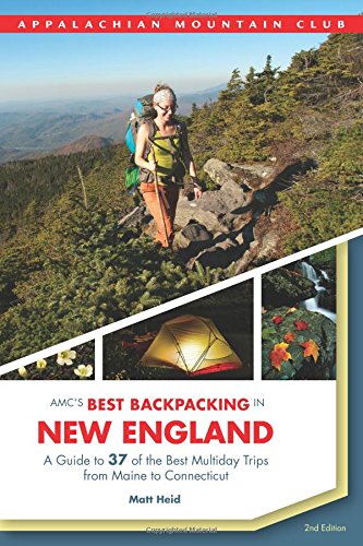
The Last Traverse; Tragedy and Resilience in the Winter Whites https://www.amazon.com/dp/1734930837/ref=cm_sw_r_cp_api_glc_fabc_QNgcGb3WAM7EN
Definitely going to read this next, thanks for the inadvertent book recommendation!!
There are a ton of options but one that comes to mind is Lonesome Lake. At just over 3 miles it would make an easy/moderate introduction to snowshoeing and winter hiking. There's a hut at the lake you could use to warm up in, if needed. It is a comparatively safe hike because of the hut and how heavily trafficked that area is (but obviously still come prepared). Bring cash if you want anything from the hut and get there very early because parking can be a pain.
mt. Chocorua is a great first big hike. But it does have 2500 feet of elevation change if you're going via the piper trail https://www.alltrails.com/explore/recording/piper-trail-to-chocura
You can also do Chocorua as a loop trail with the Carter ledge tail and others but that puts the trail squarely in the difficult category.
You can definitely get out in the whites and stay out of avalanche danger, staying below tree line and staying on low angle terrain. If you want to venture into some of the bigger lines in the presidentials, you'll want some training and partners who know what they're doing. Also, study the avalanche conditions put out by https://mountwashingtonavalanchecenter.org. They update daily, so you can follow how weather conditions affect the snowpack. And take an Avy 1 course.
Get this book by David Goodman https://www.amazon.com/Best-Backcountry-Skiing-Northeast-Classic/dp/1934028142. It's a great starting point. It's not all downhill, there are some xc tours as well.
Good beginner tours are Mt. Cardigan, the Sherburne trail, and Moosilauke Carriage Road.
This Grand & Magnificent Place might be what you're looking for. Or maybe Mountain Voices.
This loop on Greylock is pretty tough. The Thunderbolt part right before the Greylock summit was brutal (requires spikes until April at least). There is also an AT Trail Journal on Mt Williams if you want to put your name on it too.
Open Google Maps. Zoom to the Whites. Type "campground".
Looking for hikes? Google's got you fam! First result for "white mountains hiking trails" is AllTrails.com.
Call a few days ahead for busy campgrounds and have fun!
Awesome! Here's (maybe?) a link to the results:
https://www.surveymonkey.com/results/SM-C2PMM5PC/
I'd like to stress again that I'm not a survey monkey expert, so sorry if that's not the right link.
There are some reports that the water spigots are on on Alltrails.com at https://www.alltrails.com/trail/us/new-hampshire/presidential-traverse-trail. I’m planning to give the traverse a shot 6/26 so am wondering about water as well.
Definitely agree with you there. We decided to go to 13 Falls instead. Have not been but seems like a great spot for a mini vacation. I am about 2 hours away in Massachusetts, so similar position. Overnights in the whites are tough unless you pay at a spot or do a lot of googling about where you can stealth camp. I often drive back after hiking. Primitives work but are tough when you have to be off the trail, away from huts, and near water but not too close to water. All Trails has some good filtering options that include dog friendly and camping, so you can go that route. The other option is to find some 'primitive' campgrounds you can hike near. We're not hiking, but our next stop is Mollidgewock State Park, which will also be fun for the pup.
Hiking south from Gorham up Moriah, then headed north to Old Speck. 3 night trip in mid september. Can't wait. Here's the map: https://www.alltrails.com/explore/map/gorham-nh-to-grafton-notch-via-at
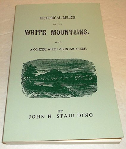
Historical Relics of the White Mountains by John Spaulding, published in 1855. Filled with wonderful old tails of the Whites, includes stories of witches and mysterious deaths!
Yes, here is a set you need Map 2.
I also have a pdf of the section, if you need that
I found this on google ( http://hudsonvalleyhikers.com/Pemi_Loop_Map_100_Percent.jpg )
I used to bump chairs in horrible weather during winters, and always wore my insulated Kinco gloves. Still wear them to ski and snowboard as well, and I never have cold or wet hands. I do buy a new pair every year though.
You can order Recco reflectors for your backpack (I found out about them when I ordered some pants that came with one) that SAR helicopters can find. It's at least something, if people know to look for you. https://www.amazon.com/Recco-Backpack-Rescue-Reflector/dp/B07JMPK3JH?th=1
They make hiking pants with trackers in them that can be located by rescuers.
>Recco Reflector - A small band-aid size battery-free transponder which makes you searchable to professional mountain rescue teams in the event of an avalanche or other emergency.
https://www.bobstores.com/ems-womens-squall-shell-pants/2070820.html
and you can buy them on Amazon, too https://www.amazon.com/Recco-Rescue-Reflector/dp/B07QDMLS76
Read this book before you do anything serious. Not trying to scare you but this is a great example of what can happen at any given time even with an experienced hiker.
I think you're just mincing words over "not difficult" versus "easy".
If someone got lost on Bond you would not say: "oh just a not difficult trail in the Whites, average even". The Wild River valley is pretty remote as well.
The fact that they are doing a 3 day backpack to begin with says that the trail isn't "not long or difficult"... it's not like people are backpacking Willard.
To quote the trail reviews: "difficult", "not for beginners", "remote", "secluded", "hard to follow", "set your compass", "unmaintained"...
https://www.alltrails.com/trail/us/new-hampshire/black-angel-trail
https://www.hikingproject.com/trail/7018168/black-angel
The only persons arguing otherwise are one trail runner, and people who haven't done it.
It’s finicky. but not “hard”.. one thing I do is use these if you’re going to be using platforms a lot.. makes it easy to drop them threw the crack and sinch your guylines tight
10pcs Fishbone Tent Stakes Pegs... https://www.amazon.com/dp/B07SN211SD?ref=ppx_pop_mob_ap_share
>In my experience I've found that tents that require being staked out >for structural reasons, tent to be more difficult to setup on tent >platforms like we often find in the Whites at the tentsights . A little >creativity can typically solve that issue.
These "platform stakes" and some cordage and you're good to go.
https://www.amazon.com/Plus-Canister-Shifter-Adapter-Function/dp/B00U2EE6M2/
Something like this? There's a bunch of different ones on Amazon and other places. Also a bunch of YouTube videos on how to use properly.
Rattlesnakeis pretty easy for a great view - did this with some friends at our peak COVID Lockdown-out-of-shapeness and had a good time. Pretty short so you may want more of a challenge, but I'd say it's quite similar to Cathedral Ledge.
I just finished my direttissima yesterday...this was my route:
https://www.alltrails.com/explore/map/map-ce11641--33?u=i
The only variation i made while on trail was I took the south slide up the tripyramid so I could drop my pack at the sleeper trail, I did an out and back up washington from where crawford and davis path meet (to take davis path instead of the tuckerman ravine trail) and also the road walk from the bottom of stony brook trail was entirely on rt16....the out and back for owls head is easier routing, head down after garfield and back up to galehead, that way when you do the twins you can head over to the bonds while youre already up there instead of having to make that climb twice.
Any chance you get for an out and back without your pack is WAY worth it.
Made this while planning something a week or two ago, I’m not overly familiar with how sharing maps works on it, but I marked all 48 on alltrails and you might be able to copy the map and just route plan individual hikes (this is for a linkup following roughly the FKT route but broken down to an 8 day pace):
We’ve hiked it last weekend anti clockwise https://www.alltrails.com/trail/us/new-hampshire/mt-cabot-loop-bulge-horn
The hike is very gradual and the trail is lovely, full of different kinds of mushrooms and frogs. We camped overnight at the unknown pond tentsite, so we weren’t rushing to get to the gate by 4pm. Some people parked their cars just before the gate, since it’s supposed to be closed between 4pm and 7:30am. So if that’s a concern for you, you can park just before the gate, it will make your hike a bit longer. If you do decide to camp at the unknown pond tentsite over the weekend, try to get there by 1pm to guarantee a spot. The view from the horn is spectacular, so don’t miss that, especially that there isn’t much of a view on Cabot, due to trees obstructing the view. Enjoy the hike!
I'm doing this trail over the weekend staying over in Saturday night. It sounds like the Paugus part is pretty isolated. Check out this map I created on AllTrails. https://www.alltrails.com/explore/map/map-2ef3dce--25?p=-1
I've used this: https://www.amazon.com/Rocky-Mens-Gore-tex-Waterproof-Socks/dp/B0751S4RMK
Looks like it's unavailable, but there are similar types out there. Might take some experimenting to find the perfect solution!
This was a little over a year ago but this was the loop I did with a few mates with the road closure. All Trails Recording You should expect this closure this time of year.
I was considering doing a sort-of loop with some offshoots to Cannon and the Kinsmans : https://www.alltrails.com/trail/us/new-hampshire/north-kinsman-south-peak-and-cannon-balls-loop-trail?u=m
The mileage is on the low end for what you want. For me it would be a good overnight but you might hike faster/longer spring-ish days. You could stay at Lonesome Lake Hut and save on weight or camp at one of the sites around.
We've had a few good rippers come through here over the winter but I think the majority of it came from the massive storm back in October.
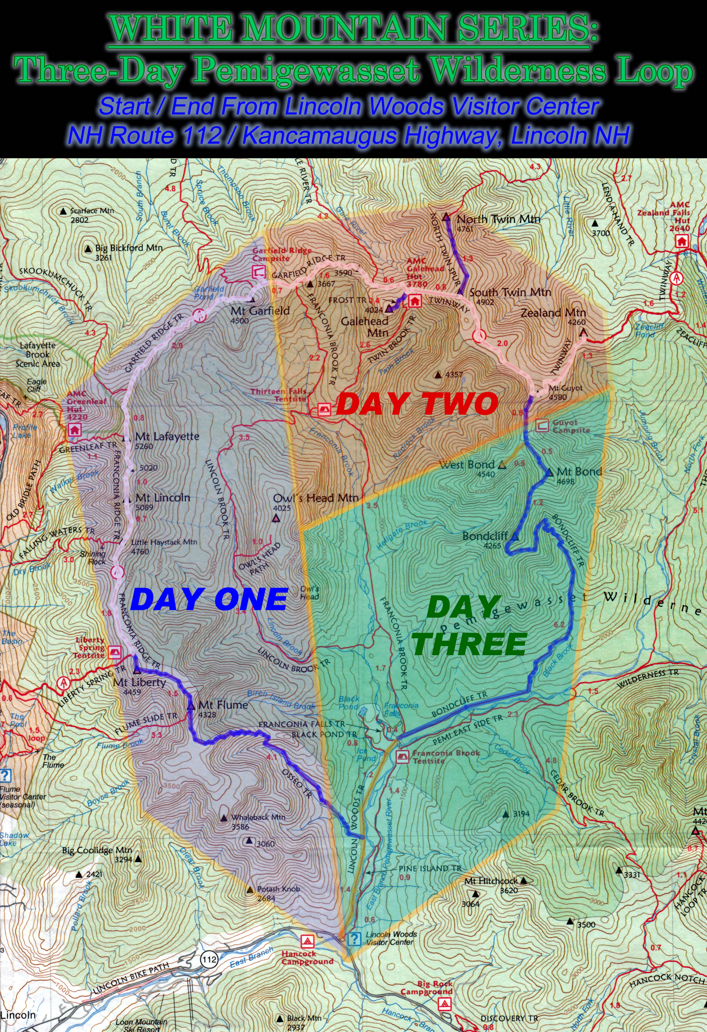
I was thinking this trail, https://www.alltrails.com/explore/trail/us/new-hampshire/north-twin-south-twin-guyot-west-bond-bond-bondcliff-zealand-and-hale-loop .
​
Going counterclockwise and adding Galehead and camping at Guyout Camp. Thoughts?
We veered off before reaching the shelter by taking the Carter North Trail down to get to Imp Trail so we never hit Imp mountain or the shelter. Here is the exact route we took: Wildcat to Carter Map
I couldn't tell you anything about that shelter or those trails beyond. I would say if you're just looking to hit the three Carters and you'd like to avoid the relentless trek from Carter Notch to Carter Dome, you could do what a lot of people seemed to be doing that day and do an out and back via 19 Mile Brook > Carter Dome Trail > Carter Moriah Trail to the three peaks and come back down the same way.
These are super useful, but not required, for setting up tents on wooden platforms: https://www.amazon.com/gp/product/B07SN211SD/ref=ppx_yo_dt_b_asin_title_o01_s00
Amazon, but target, Walmart, REI, cabelas sell them. I got this one, my dad had this when I was a kid we used to take the suburban to drive on the beach over night
Reliance Products Hassock... https://www.amazon.com/dp/B000FIDZLI
Works great. You throw some cat littler in a trash bag and throw it away when you are done of the weekend
Mikrospikes my sister is a hut master for AMC and spends a lot of winters up there and swears by these.
> I think I heard of an accident report book for the Whites.
<u>Not Without Peril - 150 Years of Misadventure On the Presidential Range</u> ^^non-referral ^^link