
What is Reddit's opinion of
Wikimapia?
From 3.5 billion Reddit comments
100 reviews of this app found across Reddit:
I know this probably won't be seen, but it's something I want to know.
On Google Maps, there's this blurred out area in Northeast Russia. Not only is it blurred out there, on others such as Bing Maps, it's obviously photoshopped over. In others, I think Yahoo, it's just blank. There's obviously something here that's being hidden, and the curious person in me wants to know.
You can commission some services to receive custom satellite imagery, and hell, I considered it at one time just as a "why not", but their tool actually wouldn't let me get into that area to get a photograph taken. I'm not a huge conspiracy theorist, but this has gotta be something that we're not supposed to know about. Blurring and pixelization of sensitive government areas is a given, but this is something completely different.
That damned UVB-76 thing months ago got me all hyped up on crazy Russian mysteries...
Edit: NoisomeOne provided this gem of a link which pretty much sums up all of the same things I had heard or found out about online, along with some supposed photos from the area. Says that it's owned by the United States. Hmm... crazy shit if true. If the photos are actually from this area, it looks like they're keeping it in somewhat decent shape. Find his comment and give it an upvote.
the russians acknowledge the importance of laika several times over including a statue that's actually quite beautiful.
http://www.universetoday.com/13606/russian-memorial-for-space-dog-laika/
There is actually a whole Saudi palace/huge villa there, it was there since forever and it didn't look like it was used much by actual royals at all during King Abdullah, but during this month there are hastily day and night ongoing renovations. I heard that 2 days ago there was a small scuffle with Saudi security there, and the actual closing off of the beach was initiated after an all-night party at that beach(14th July is huge in France), and that beach is less than a few hundred meters of Saudi living quarters. http://wikimapia.org/10600755/Residence-of-the-Royal-Family-of-Saudi-Arabia
Source: swam on that beach yesterday morning and conversed with a local, like to spend my vacations in the vicinity.
Might be a seaweed farm, according to Wikimapia
The creepyass thing on the right, you mean? It says ningyo no miira, which is some kinda Japanese Fiji Mermaid hoax.
You should go see it, OP. It's apparently at this temple.
Like everyone else here I have been trying to piece together the information that is being provided... US thinks the MH370 headed toward the Indian Ocean... For the amount of money that the US spends on military and surveillance I'm willing to bet they are closer than anyone else.
Here is a theory... Reservoir Engineer had posted some maps of radar coverage and possible routes that would have the best chance of avoiding detection. With the US claims of the plane flying west and the maps I mentioned above I started searching for landing strips that would fit... It looks possible that the plane could have landed at the Great Coco Island Airstrip and may never been detected. Possibly even refueling...
According to wiki it is a Chinese military airfield that appears to be unmanned and rarely used with a 4600 foot runway. Necessary stopping distance of a Boeing 777... 2000 to 5000 feet...
Wiki Info: http://en.wikipedia.org/wiki/Coco_Islands
Wikimapia: http://wikimapia.org/3523609/Coco-Island-Airport-Myanmar
The source made me suspicious so I did a little research.
Appearently, this airport is being used by the Turkish army for operations against the PKK, pretty much since the beginning of the invasion of Iraq.
Also, the fact that this airport is already visible on Google maps, makes clear that it has been there for a while already...
This video was shot in late March this year in Al-Bo Amer village near Deir Ezzor Military Airport, one of the two brothers (Ibrahim ابراهيم حمود الحسين) was killed in the explosion of the mortar that was fired from the airport base and the other one was severely wounded.
Woah, woah, woah! I used to live here. I recognized the intersection immediately, it did not change much. Here's the location on wikimapia:
The plane is coming in from the north towards south
It was a Shabiha checkpoint in Idlib blown up by Syrian rebels. Notice the watermark in the upper right? That is the logo of the Islamic Front. They are the non-al-Qaeda affiliated union of domestic Islamist groups. They want a Sharia state in Syria but could give a shit about attacking the infidel where he sleeps.
Best guess from r/SyrianCivilWar puts the location around here.
http://wikimapia.org/#lang=en&lat=35.640330&lon=36.710365&z=17&m=b
To avoid confusion.
The convoy was heading to/coming from KarAbila not KarBala.
Karabila is on the Syrian/Iraqi border and can be seen here.
Most edits are now making this distinction to clear up any of the obvious confusion!
It was actually probably mined (tunnel dug underneath the building and filled with explosives).
This apparently happened in al Mahila, which is on the southeast side of Damascus. The opposition around Damascus in general have been digging tunnels for a long time, so it's reasonable to conclude they're quite skilled at it. It also goes without saying that opposition forces know how to set us up the bomb.
According to the facebook page for Al Rahman Corps, the group that posted the video (page is in Arabic, recommend using Chrome for the auto-translate feature), they've been attacking the "general administration for the air force" since January 23, so that's probably more than enough time for them to dig a short tunnel and get everything into place.
Anybody want to go to Chicago to investigate this? http://wikimapia.org/#lat=41.882333&lon=-87.784&z=19&l=0&m=h It's indeed in a school zone and picture was taken just 4 hours ago so I'll go ahead and believe it. Also, does the "Nick's Pizza & Beef on Madison" down the road deliver? If so what would you like?
Air base:
https://www.google.com/maps/search/Primorsko-Akhtarsk+Air/@46.0570988,38.2285692,347m/data=!3m1!1e3
From other photos, looks like vehicles are in active service due fresh tracks on the ground (opposing to being in a storage as they usually are). Although, this is consistent with a military exercise as well. On the other note, it will be pretty dumb not to get some military ready when your neighbour goes haywire and has a tooth on you.
By the way, don't piss your pants:
http://wikimapia.org/#lang=ru&lat=46.535292&lon=39.611582&z=17&m=b&tag=516
Just to show how ridiculous the word "massing" in the title is.
This is why I hate wikipedia. Can I get at least a fucking map of the island to get an idea? No, but I can read about its dimensions somewhere around the middle of the article. Great, thanks.
Well, I found a map here
Additionally, they handle their incoming and departing traffic pretty damn well. Obviously things get backed up when it's the fucking hub for one of the largest airlines in the world, but it seems to generally avoid "well folks we're number seventeen for departure"-syndrome.
They have their incoming flights land on the outer runways and on one side of the airport they created a taxiway around the departure end of the inner runway so that there can be a continuous stream of landing/departing traffic from the two. Sometimes called the victor loop or victory loop.
Also, some nice things from a pilot's perspective is just how easy it is to taxi anywhere in the field. Ramp control gets you out and to the appropriate side of the ramp, and then with ground typically, it's a pretty simple taxi out. Compared to an airport with as many turns as Houston-Bush (IAH), it's a fucking breeze.
ATL Diagram to see how well laid out it is: http://flightaware.com/resources/airport/ATL/APD/AIRPORT+DIAGRAM/pdf
IAH Diagram: http://flightaware.com/resources/airport/IAH/APD/AIRPORT+DIAGRAM/pdf
Also with respect to the original question, I fucking hate Chicago Midway.
It was probably moved to make way for construction/development. A decade ago in my hometown there was a big to do about a 400 year old oak that an activist chained himself to because they wanted to move it to make a road wider, and evidently the older a tree is, the less chance it has of surviving a move.
Did a quick search for the thing and apparently it survived the move just fine. Also found an article listing that tree's weight as 460 tons.
Subs have a purpose built degaussing facility. We just park the boat in it, clear off all of the magnetic data back up tapes, and flip the switch. It's not strong enough to hurt anyone, people are still running the reactor as the thing does its thing.
Here's a link! http://wikimapia.org/6597074/Degaussing-Deperming-Facility
They are coming home after 45 days work shift on Bovanenkovo-Uhta gas pipeline,
part of the bridge over Nyarmayakha river was washed out
interesting. I didn't see that before. It is the M/V Pimrose, stranded in 1981. After that fights broke out:
This is where the tank backed through the concrete wall.
The camera man was filming from one of the highrises around here.
Location:
http://wikimapia.org/#lang=en&lat=35.713730&lon=36.057773&z=15&m=b
This is pretty significant if it gets confirmed. Qassab mountain dominates the nearby area around along with Nuba that SAA captured few days ago. Suddenly they are in position to really threaten supply lines towards Salma and are close to Baradun Dam. Whole that area north-northeast of Qassab and around Baradun Dam is sort of crossroad. They are now in position to get down towards villages on the one of 2 supply routes to Salma and approch it from the west. There was some reports of some advances towards Salma on the east side too but that area will require a lot more time. Still, this is pretty significant position, if they can keep it.
They are with this also suddenly less than 5(?) miles from Rabia from the south too which is second most important rebel stronghold in Latakia after Salma. There was significant avance north/northwest of Rabia for a while now. Any further advance to the north of Qassab will create dangerous salient for the rebels east of Rabia, in Toros area. If rebels are forced to withdraw from there Rabia will become pretty exposed. Salma and Rabia are main goals in the long run. Capturing those would significantly reduce the size of the Latakia rebel pocket and allow SAA to plan further push along the Turkish border towards Jisr.
This might be one of the most important developments on Latakia front recently. Hopefully we'll get more confirmations.
VOR, aircraft navigational beacon: wiki
And to be precise: This one in particular.
There's another one rusting away in the Arizona desert.. If you have base access, you can check it out. But watch out for bees, it's filled with them. If they ever recommision this particular one, it would be simple for them to launch thousands of bees into space. Don't tell the Russians.
Well, I think a major factor that people aren't seeing, is that the SAA is significantly shortening frontlines on some major fronts, and strengthening others by gaining the high ground and other defensive positions.
This push has already removed the Hadaddin salient in Southern Aleppo, and I am guessing they're aiming to remove the other one, while also capturing all major high-ground positions.
The Northern Hama offensives aims to remove the Rebel salient and positioning the SAA in several strong-points such as Khan Shikoun and the highground South of Tamanian.
The Northern Homs offensive aims to reduce the pocket, opne the road, possibly in order to lessen the amount of forces needed there, which relates to you point 1 and 2.
Latakia and the al Ghab offensive has as only goal to gain the highground, which will give them sigficant strategic leverage, with the theoratical capture of Salma and Sirminyah. This will help the SAA push to Jisr which will remove any danger to the coast, reduce/remove the pocket, and will give SAA the high ground that is the Latakia mountains.
This all relates to your points, which I all agree with.
Footage is not from Mallah farms, but from Layramoun
Loads of conflicting reports at the moment so its best to wait before rushing to conclusions, especially since this would be a major development in the war.
Edit: Thanks to /u/waitingandseeing, the actual tower is this one here, it coincides with the barrier as can be seen by this satellite imagery. This means that it was probably taken from the Layramoun industrial area. Located here where the government forces have been carrying out an offensive.
My god! That's only 17km away! Kurdish forces are on a fucking roll.
Remeber that current YPG lines are racing towards Slouk, and between there and Abyad it's pretty much empty.
EDIT: It seems like Tall Abyad will be the reverse of the situation in Kobane. A surrounded city from all sides (since I think both sides will wait on the other), except on the Turkish border. This will be a field-day for the Americans.
Google maps of this pond, anyone? :)
If Aleppo falls by the end of the year the government claimed it will then I can see a good majority of rebels laying down their arms and either going into exile, taking amnesty or even defecting back to the SAA in order to fight ISIS.
Also I was not aware the military academy is about to be/has been retaken, the SAA really is moving rapidly. Location here: http://wikimapia.org/#lang=en&lat=36.324202&lon=37.248502&z=15&m=b
SAA capture the Flin Jeans, Yeast factories + Brewery in Owaija district, Aleppo
Source: https://twitter.com/sayed_ridha/status/783587001773600768
Location of the factories: http://wikimapia.org/#lang=en&lat=36.261413&lon=37.181457&z=17&m=b
That is some pretty big ghanima, no organized retreat here. Almost unbelievable that these guys ran from 1 tank and 1 BMP with fighters when they have a defensive position with a lot more men and material. Then again we have seen them run like that many many times. Btw it's Ash Sha'ta village.
It seems as though the Mulleted Martyr is growing a beard as well.
It's hard to figure out exactly where they fired from, but here is Jub al-Ahmar. It lies approximately 16km SW of Jisr al-Shugur, 14km W of Qastun, and 8km SE of Salma. In relation to the rest of the theater, it is on the eastern edge of this map, on the opposition front lines just 8km W of al-Ziyarah.
Edit: Updated distances to better reflect firing location. Added a map of the Latakia theater.
NSFW: https://pbs.twimg.com/media/CAVq3UNUIAASemK.jpg
"Tripoli مقدم الشام @macroarch 17s18 seconds ago
This victim was killed in the security branch 227 headed by Major Gen. Rustum Ghazaleh. Loc :
http://wikimapia.org/#lang=en&lat=33.509975&lon=36.273798&z=17&m=b
https://pbs.twimg.com/media/CAVspqcVIAEk9vZ.jpg:large
Agreed - Rebel twitter feeds are putting out terrible photo after photo of the victims at the moment. Men, women, the young, the old, Shia, Sunni, Christian, Kurd - the regime has starved, tortured and murdered them all. I don't care if it falls foul of Godwin's law because it is true; as you say the only meaningful comparison with this is Auschwitz.
But good news everyone - the regime is secular!
Hi Colonel Warren,
Thanks for taking the time to do an AMA.
I'm a contributor at the Bellingcat project that aims to geolocate all airstrike videos uploaded to the Internet by all countries conducting airstrikes against the so-called Islamic State and other groups in Iraq and Syria (link to the project website: https://bellingcat.checkdesk.org/en).
I have a question about a specific video of an airstrike uploaded to YouTube by the CJTFOIR account. The description says to show an airstrike conducted on March 23, 2016, near Al Hawl, in Syria. This is a link to the video, https://www.youtube.com/watch?v=qkgRft0xAQ4.
However, the building targeted in the airstrike is actually in Iraq (though very close to the Syrian border). http://wikimapia.org/#lang=en&lat=36.137411&lon=41.297414&z=19&m=bh
Therefore, why was this video labelled 'near Al Hawl, Syria', when the target was in Iraq?
Actually they were looking down on "Little Kufayr" from "Bigger Kufayr". Look at the retreating force from where they are retreating and the buildings and look at this here:
http://wikimapia.org/#lang=en&lat=35.776687&lon=36.320071&z=16&m=b
It actually more than confirms the rebels controlling Bigger Kufayr. Hell even look at the L road they are driving and retreating from. It is that very road. Also notice the batch of little trees, it is the same patch from right left of that little street town.
it is staged. They are not even firing at rebels positions.
From the road look and the surrouding you can tell they are in this area and firing in direction of Jurf al Sakhri. The latter location is held by pro Assad force since the Castillo road was cut.
Credit to /u/passerby_me from /r/CombatFootage https://www.reddit.com/r/CombatFootage/comments/52rn9x/another_angle_of_the_fight_that_occurred/
According to rebel comment the 5 fighters we see entering the building at 1:40 are rebels and they succeed to push back the 20-30 pro-regime fighter we see leaving the building after.
A map of the area if you are not following closely this conflit : https://twitter.com/ahlalsham3/status/769929965529919488 + http://wikimapia.org/#lang=en&lat=36.165047&lon=37.114745&z=18&m=b
This is the same area of the "Wall of death" and the countless ATGM and artillery rebels videos of the last few weeks.
One of the worst meatgrinder of this war already.
~~Possible~~ location of the fighting starting arround 6-45 and camera position
Taking this ridgeline/hill was actually really important, because it overlooks most of the area(Al-Baghiliyah ) behind it as you can see in the last shot and on the map
edit im fairly certain now
TK-20 Severstal' farthest,
TK-17 Arkhangelsk next to it (the one with the famous walkthrough)
both mothballed
so I am guessing the one in front showing its broadside is TK-208 Dmitriy Donskoy
You can see them in this sat picture of Severodvinsk http://wikimapia.org/#lang=en&lat=64.572875&lon=39.768384&z=16&m=b Plus, a third one docked to the south
Here they are again in cold weather
k30.kn3.net/taringa/7/F/9/4/7/4/JuanpastorDiaz/E82.jpg
It is of Islamic Relevance:
> The Last Hour would not come until the Romans land at al-A’maq or in Dabiq. An army consisting of the best (soldiers) of the people of the earth at that time will come from Medina (to counteract them).[6]
Their official magazine is named after the town.
I'm just copy pasting my last comment, where I quickly translated this Milliyet article regarding this incident;
> It happened at 00.30 am, 15km away from the centre of Ceylanpınar, near Gökçayır district. 3 Turkish soldiers, who were guarding the border, were killed, from an attack which came from the Syrian village Telhanzir (Tel Khanzir?). Turkish Special Forces were immediately sent to the scene. Recently, there has been heavy clashes between YPG & ISIS Fighters in the Syrian village Telhanzir (Tel Khanzir?).
Location of Tel Khanzir
Update:
And this just in case it helps narrow down.
One of them came from Jablah (Lattakia) and another from Raqqa. The one from Raqqa joined the Free Syrian Army in the beginning. He then saw injustice committed by some of the rebel groups, joined Northern Sun Battalion and now fights for them in the SDF. He says that right now he is happy to fight because he feels like he is fighting for his people together with people from other ethnicities.
Location: http://wikimapia.org/#lang=en&lat=36.169200&lon=37.048817&z=13&m=b
Khan al-Assal massacre https://en.wikipedia.org/wiki/Khan_al-Assal_massacre
Moments Before Execution Of 51 Soldiers In Khan al-Assal https://www.youtube.com/watch?v=Nbf3L_8jzfE
Map of area. The blue pin represents the area taken by rebel forces in the last day or two, including the area in this footage.
Wikiamap of location.
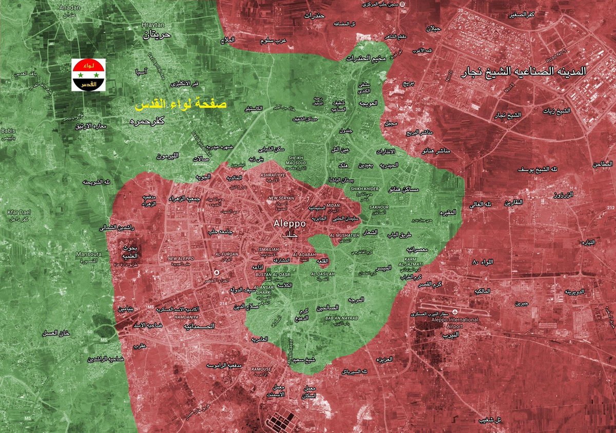
This is a map of the rebel and regime held areas of the general area as of December 28th. The pushback by rebel forces in the al-Brueij area is important because the regime forces had been slowly gaining ground and were trying to complete an encirclement of rebel forces by pushing through the Shikh Kider area to Midan and thus making a large encirclement of rebel forces.
Militants' morale is down in damascus. Darayya was taken, East ghouta shrank to half its original size in a few months, saa advancing on every front it targets
This will encourage more of them to surrender&be transferred
That'd be Camp Trinidad, a World War II Prisoner of War Camp, where the US detained German soldiers during the war.
A Wikipedia list of POW camps lists it as well.
Best I can do until someone who can speak Arabic translates, there is definitely more info in there I couldn't make sense of:
The offender Jamil was fired by the JaT a month ago based on the ethical complaints made against him.
The two individuals executed were married.
Ziyad Jaafar (Abu Issam) and his wife Shirin.
They were executed 1 km away from Jamel's home around the الشهباء (Shahba) area west of العلقمية (Alqamiyeh). I can't find Shahba but I did find Alqamiyeh.
They were found in a remote house.
According to this they were civilians.
Bdama and this hill: http://wikimapia.org/#lang=en&lat=35.801247&lon=36.262093&z=12&m=b&show=/34570173/Ruwaysat-‘Alī-Būghā&search=Bayt
If both under SAA control, Insurgent remnants SW of Jisr al Shughour will have to retreat North since supply routes will be under SAA artillery fire.
Leith mentions that they've passed the railway, but disputes the full recapture. However, if you look at the map, past the railway pretty much means that the SAA holds 90 percent of the town.
Fought alongside Syrian Arab Army, National Defense Forces, Syrian Republican Guard's in both Hasakah and Deir Ez Zor
These Two Photo's are the last 2 photos taking of him (That I know of) Yesterday after capturing new points @ Ard Turdah "Mountain Turdah" جبال الثردة area - http://wikimapia.org/#lang=en&lat=35.241746&lon=40.110741&z=15&m=b&show=/33473528/Ard-Turdah-Mountain-Turdah-جبال-الثردة
It needs to be mentioned that any group of RuAF military jets has flown to Latakia led by either a Tu-154 or Il-76 from their airfields. The "regular flight" (personal rotation, high officials,...,) Tu-154s and Il-62Ms indeed always go from Moscow to Latakia. An-124 heavy transport flights always go from Mozdok to Latakia. This flight not starting on the civil Moscow airport but from this military airfield makes it likely to be leading a group of military aircraft.
You're right. The area directly controlled by the Government is this area.
It would mean they're frontline is somewhere along this line, which would further indicate that earlier reports that these two towns were capture, are infact, true.
as far as I can tell this is the location
And checking the recent Kobani map it looks like a marked spot where conflict was taking place so it would seem like the right one.
It is true, here is a video of a fighter shooting from the turkish side.
https://www.youtube.com/watch?v=PcdqSkDIWTI&feature=youtu.be
here is the location on maps, landmarks match up, end of the video zooms out to see the silos if you didnt watch the whole thing
http://wikimapia.org/#lang=en&lat=36.900442&lon=38.352105&z=19&m=b
First building with a rebel seen inside at 2:45 is here - http://wikimapia.org/#lang=en&lat=36.253464&lon=37.187152&z=19&m=bs
2nd building they hammer at the end is here - http://wikimapia.org/#lang=en&lat=36.250192&lon=37.185540&z=18&m=bs
Here is the crane in the background - http://wikimapia.org/#lang=en&lat=36.243233&lon=37.185124&z=19&m=bs
Christ, we're seeing the Northern rebel lines truely crumbling as we speak. Watansy is reporting that there is more to come as well. We might even already see a push moving South soon.
>According to the report, the airfield was used by Hasakeh’s Directorate of Agriculture for crop dusting and has been out of service since 2010.
i have been trying to find something that resembles their claims and is to the south or south-east of Rimelan. They might be talking about this place which is also close the to village called Al-Buthah which might be the same place the report calls Rimelan Al-Basha. Though it is a very short and dilapidated looking runway it is the only one i could find anywhere near the place they are talking about and maybe it is good enough for crop dusters.
edit: appartently somebody agrees with me because now there is a new tag on the area for an US Air base under construction
EDIT: Because I really don't have a lot of other shit to do I've made an outline of how the frontlines in Eastern Aleppo are likely to look around now.
Pretty close to airport. Wouldn't be wise for insurgents to keep their ammo there.
P.S. Have you seen who'd been there in 2005?
Dunno where you got that from.
This is the location of that photo: http://wikimapia.org/#lang=en&lat=36.524510&lon=40.738624&z=15&m=b
It's 1.5kms north of the northernmost-SAA positions in Hasakah: http://wikimapia.org/#lang=en&lat=36.512189&lon=40.743570&z=14&m=b&gz=0;407384204;365124990;36048;0;0;125541
Deep within the YPG's half of the city. SAA obviously never held that place.
This happened summer 2013, but the SAA hasn't advanced much since then. Funny enough, they uploaded another GoPro-tank video of this exact same courtyard on October 5th.. This one is coming from a different angle, though, seen here.
We had a walk in cold beer cube in ours..then they redid it...it turned out it wasn't big enough and was hampering sales...but goddamn did it look glorious...it was right across from the subs too.
ClubPub what up!
EDIT: For the uninitiated it is the primary grocery store for FSU located across the street from a huge Fraternity community. It was ranked by Playboy as one of the best places in the country to meet someone. Rumor has it that after the announcement a DJ was invited to throw a party there cementing its nickname, Club Publix.
Yes. You can. http://wikimapia.org/#lang=en&lat=36.144091&lon=37.123988&z=18&m=b
Not the orchard with the road that cuts in its front, it matches the footage exactly at 0:12 - 0:14, the buildings, and the constructed rampart. It all matches.
http://wikimapia.org/#lang=en&lat=36.145900&lon=37.119882&z=19&m=b
This is the half destroyed building seen at 0:22.
So yes. Its provable.
I'm having a really difficult time with geolocating this, but it may be this position here. It could also be here perhaps. Based on the building's shape, the terrain (pavement), and tree proximity it could be either one, but both are on the north side of the base and suggest that the government is inside.
Just look at the geography. The defenders of airbase are seeing the trucks coming and even if such a truck would made it to a barrier, it would cause only some damage to the barrier, but no soldiers would be killed. And the barrier can be fixed afterwards. And even if ISIS should manage to overrun the first line of defensives there is still a second and a third one to also overcome. Currently ISIS improved a little bit their strategic position, becasue they captured the missle batalion here: http://wikimapia.org/#lang=en&lat=35.251963&lon=40.186186&z=15&m=b But you see it is still a long way...
Approximate Geolocation two child soldiers on the left at 1:09
SVBIED at 2:58
2nd attempt at 3:15
A M16 I think at 4:10
Also notice the child soldier at 6:28, 7:38
A rare M16(? I believe) at 6:48
Something I cant identify at 9:08
They were fighting a iraqi army outpost in the hills supported by most likely local militias. This battle is part of IS choke-offensive on Baiji refinery, as it takes control of its east and cuts supply lines (those north and west of Baiji already controlled)
Love canal. Not in the same state but still, dioxin. Fun stuff. Times Beach was really interesting in the way the contamination happened. They are both also on a pretty short list of entire towns lost to pollution/accident/industrial disaster in this country.
There was also 'Mount Dioxin' in Pensacola, Florida. http://wikimapia.org/11798816/Mt-Dioxin but for some reason no one ever talks about that one.
You butchered the information of the tweet.
Yusha Yuseef also said that the SAA has captured Tel al-Duwayr, east of Souran.
As you can see it is East of the defensive walls. North west of the water body they were using as a buffer and previously rebel held. I'm not sure if this is true or not but entirely possible a successful counter attack occurred especially if rebels are really fighting among themselves (isn't an unusual claim and rather believable).
For those who were confused on first glance as I was, Angel city is Inkhil. Inkhil is just to the east of Jasim, held by the rebels, and south-west of Sanamayn, held by the government with the Brigade 15 military base close by.
He also claims that the SDF accepted the wish of the Shaitat tribe to liberated their homelands all the way down at the northern shore of the Euphrates.
Location, this is the border crossing between Turkey and Idlib and coincidentally the main supply road of the rebels.
> Wow, if this map is accurate
It is not. Aleppo24 wrote that they reached a cemetery from the north which means it has to be one that you first reach from the north which would be this one. He just read cemetery and assumed it would be the large one in the city center.
Same happened a few days ago when there were reports about the SDF taking control of a hospital, while it was actually a small medical center in Qanāt ash Shaykh Tabash he just understood hospital and marked the National Hospital of Manbij.
My approach looks like that: http://i.imgur.com/UeFaqVy.jpg
I may have found the location of this. Note the positioning of the buildings and what look like trees.
http://wikimapia.org/#lang=en&lat=35.941324&lon=39.020026&z=17&m=b
Look at around the 0:25 mark, when the video is looking roughly south west.
Keep in mind that this is mostly desert roads, so looking in kilometers has to be nuanced, similar to when the SDF captured 400 sq km of sand it can often seem like a huge change yet it doesn't mean in terms of real gains.
~~Other than that this was captured recently by the government forces.~~ Wrong location, my bad.
This is the right location of Bir Abu Al'Allaj.
The location appears to be in the parking lot of the old Shaktar stadium, which is here
The video is supposedly taken on February 23rd and shows a battery of 4 artillery guns firing in a North North-Easterly direction.
Edit: Looking through twitter feeds I found this tweet made on february 24th in which photos of a 4 gun battery is posted. Pictures taken in daylight confirms it's most likely the same battery as shown in the video.
I don't think this article is true. The picture shows Siyasiyeh Bridge in Deir Ezzor. If I remember correctly, this bridge was destroyed last year. This is one of the bridges (both are destroyed) which leads into the daesh-controlled part of Deir Ezzor. Maybe daesh rebuilt it? I don't know... but I don't think they are able to do that.
It says it's 50 metres from the site of the Gracedieu.
So I'd hazard a guess that it's right around here: http://wikimapia.org/#lang=en&lat=50.892206&lon=-1.289445&z=17&m=b&v=1
https://en.wikipedia.org/wiki/Grace_Dieu_%28ship%29#Rediscovery
'Sham Front' is presumably Jabhat al-Shamiyya, or what is sometimes (possibly incorrectly) called the Levantine Front.
'Sawran' is another transliteration of Soran, which is a small town near Mare, north of Aleppo.
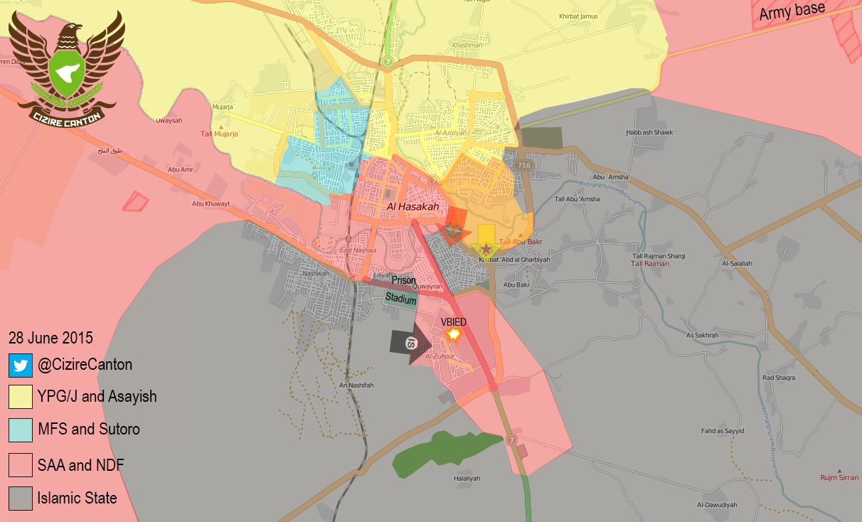
I coloured in the recaptured area (green) in the CizireCanton map.
Old map: https://pbs.twimg.com/media/CIk8DThUsAE6WXU.png:orig
New map: http://i.imgur.com/zt9QsZr.png
Sources? SAA is sustaining heavy losses in al-Milah, but that village is very big so this does not mean the entire area is lost.
EDIT: Elijah Reports that fighting is still going on. The area is NOT lost.
IS captured most of Jaffra some weeks back and was able to reinforce isolated troops on Saqer Island (crossed the eastern river bank). SAA flanked coming from SW (Airport) and recaptured most of Jaffra again. After that, ISIS was forced to establish a new supply route - the fisheries. Here: http://wikimapia.org/#lang=en&lat=35.313514&lon=40.193310&z=14&m=b&show=/32065716/Fisheries&search=Deir%20Ezzor However, Anafat bridge, and Aleesh garden are under SAA control already. If fisheries fall too, IS will be in big trouble there.
Next map will be a Saqer Island close up btw.
They are blocking it by not demilitarize the roads connecting to it like the road from Kafr Hamra which is rebel controlled:
http://wikimapia.org/#lang=en&lat=36.258117&lon=37.093277&z=12&m=b
aid wouldnt be able to pass through safely.
This is just trolling of the IS by the YPG/YPJ.
Dabiq is for the Moslems the same as Armageddon for the Christs.
Armageddon = Har megiddo, the hill of the former town of Megiddo in Israel. The place around this hill, where the bad will collect the army and where the last of all battles will be performed, the good against the bad -> and the good will win. This is part of the Apokalypsis part of the bible.
Dabiq is the same. There the bad will attack the defending (good) and the defending forces will win. This is than the start of the end of the world and the Messias will later come and so on and so on...
So, if the YPG will bitterly defeat the IS in Dabiq, it is the prove, the end of the world is still far away....or so. By bad luck, even the IS do not really believe in it.....
But the name was important enough for them to name their IS Magazine "dabiq".
And as it is not so far awayr from Afrin: http://wikimapia.org/#lang=de&lat=36.540164&lon=37.268665&z=15&m=b
This is Tuz Khurmatu. When you click on the parts of the town you can see it's nicely organised in kurdish, turkmen and arab districts.
Jabal Al-Arba'een: http://wikimapia.org/#lang=en&lat=35.942227&lon=37.161255&z=14&m=b&show=/25803951/Jabal-al-Arbaain&search=aleppo
Tal al-Bak'kar(not 100% sure): http://wikimapia.org/#lang=en&lat=35.928745&lon=37.084436&z=15&m=b&show=/10629522/Tall-Bakkarah&search=aleppo
Deir Hanna
http://wikimapia.org/m/#lat=35.6922411&lon=36.0179488&z=13&l=0&m=b
Daghemshalliyya
http://wikimapia.org/m/#lat=35.6946112&lon=36.0478179&z=13&l=0&m=b
Note: links only work on mobile
pure rebel propaganda. wear a tinfoil hat when reading. full of conspiracies and groundless predictions.
ISIS has been raiding this area from Aqaribat for a long time: http://wikimapia.org/#lang=en&lat=35.098563&lon=37.464752&z=12&m=b&gz=0;372893142;350259198;1658248;0;2015304;146182;1768112;312010;1514053;157425;10299;972180;164794;969372;58364;868274;0;952523
ISIS front in Baiji collapsed, Mosul is in danger and their troops in Salahudin risk encirclement, in the North of Raqqah the Kurds are massing troops and equipment, in Aleppo the SAA is nearing Kweires. And what does ISIS do [according to rebels] they plan attacks Hama.
Tal Brak in wikimapia: http://wikimapia.org/#lang=en&lat=36.675647&lon=41.042347&z=14&m=b
With the way things are going, I'd expect YPG would have taken it by tomorrow. I just hope that the archaeological site in Tal Brak hill doesn't get damaged from either YPG bombardment, Coalition airstrikes or if for some reason, IS spitefully destroyed archaeological site.
Great news! can't wait to get it verified and can't wait for the new maps.
This is one of the villages(Manaza)
Another one of the villages(Cikur)
The other two have not been identified on the map.(Al badur, Arbosh)
They will secure the Deir ez-Zor-Palmyra highway(M20 I think), anything else would be both pointless and counterproductive. Al-Shulah and al-Kabajb are the only villages they need to capture: http://wikimapia.org/#lang=en&lat=35.131702&lon=39.774628&z=11&m=b
When they capture those 2 villages, the 400km highway from Damascus to Deir ez-Zor will be entirely in government hand and the government doesn't have to worry about IS advancing from Deir ez-Zor into Palmyra and then from Palmyra into Homs and Damascus.
Actually, they were caught near the village of Dzerkalne.
If you take the shortest road from the border it's still almost 30km.
Guise! Guise! Hear me! Guise!
Srsly, if you want to see canon like that, just visit Moscow and go to the museum on Poklonnaya gora. Subway station Park Pobedy (blue line of subway).
HERE is the same 305mm canon, you can watch it easily.
(Also, if you come in this park from may till september, you'll see a lot of beatyful russian roller and scaters girls. See ya around!)
It wasn't entirely RIT's fault. When 490 was built, part of RIT's urban campus was claimed under eminent domain (source). They weren't very pleased about that, especially since some rather essential buildings were claimed. Rather than spread the campus across Rochester (like, say, Boston College does in Boston), they consolidated, moved out of the city, and bought a patch of land that no one wanted for anything so that they wouldn't get kicked out again.
I would also question your logic about RIT causing the suburban sprawl in Rochester. There's no doubt that Rochester's suburban sprawl is a problem, but this source suggests that it's been that way since 1970, a scant 2 years after construction on the new campus started. Also note that suburban sprawl is never directional; it always radiates out from a central point. In this case, Henrietta is just part of a bigger equation. Also note that the town has existed since 1818, and has grown naturally in that time as well as the growth induced by RIT's relocating here.
TL;DR: I actually kinda like it here. Also, some of your accusations are wrong, so learn you some history.
Edit: Removed the following paragraph because I couldn't find a source for it. I know that RIT was built on wetland, but can't confirm that it wasn't also built on farmland:
Also, FYI, RIT was built on undeveloped *wetland, not undeveloped farmland. Is that any greener? Hell no; it's probably worse, considering how endangered wetland environments are , but I just wanted to set the record straight. I think it is important to note, though, that RIT is pretty much hell bent on preserving the remaining wetlands, and there are actually student groups and science classes that have been reclaiming parts of RIT for the wetland environment.*