
What are
/r/BikeLA's
favorite Products & Services?
From 3.5 billion Reddit comments
The most popular Products mentioned in /r/BikeLA:


The most popular Services mentioned in /r/BikeLA:
Ride With GPS
Strava
MapMyRIDE
AllTrails
Weatherspark
Windy
Weather Underground
OpenStreetMap
SurveyMonkey
IFTTT
Google Groups
EveryTrail
TripAdvisor
The most popular Android Apps mentioned in /r/BikeLA:
Sprocket - Find your Bicycle & Bike Catalog Specs

Windy: wind, waves and hurricanes forecast
The most popular reviews in /r/BikeLA:
should be closed starting at 10 am this morning (Friday) until Tuesday.
Here's the route - if you go to the village, the navigation key is ALWAYS take the uphill option at both intersections. Works both ways too.
Daytime running lights, especially this rear 350 lumen tail light, it is so bright cars see it from so far away. I run this during the day and cars see me from so far back and always move into the other lane way before they get to me.
If you're willing to drive to azusa area, you can take that bike trail from the bottom of azusa (hwy 39) to seal beach which will give you around 75 miles of nonstop bike trail round trip.
example https://www.strava.com/segments/846900
And if you want to do some climbs, climb up azusa first to the fork and back down should give you the rest of the 25 miles
example
https://www.strava.com/routes/5086538
just do half of this loop, and then you can begin the ride to seal beach and back. Should give you a full century round trip.
Good luck with your century.
It's only a 25 mile ride from your start, but going to the back of the Hollywood sign and then to the Griffith Observatory is a pretty great ride for out-of-towners. Make your friends back home jealous. There is climbing, no spiders (maybe). Link to route starting near you.
EDIT: If you want a longer ride with more climbing, Mt. Wilson is an iconic ride around these parts. Route here.
EDIT 2: fixed link
Baldy is not hard at all. It's pretty long but never gets steep. There is plenty of street parking on Glendora Mountain Road just north of Sierra Madre if you're driving to there. Temperatures are nice this time of year too, it can get brutal in the summer because there is no water between the equestrian park at Dalton canyon and the village.
The first 8 miles or so are uphill and then there's a brief down hill before a short climb to the first real landmark - the shack. Mile 9 to mile 14 are mostly rollers (GLendora Ridge Road) and then you have another 3 and a bit miles of climbing and a steep descent into the village. Its a pity but the lodge probably isn't open, but you can probably refill your water at the fire station - there's a hose bib outside. Turn around and head back the way you came and you'll have a nice 44 mile, 5400 feet of climbing sort of day.
Navigation tip: there are only two intersections on the route. Going to the village always take the uphill option and coming back from the village always take the uphill option. :)
You can also go the back way through Camp Williams if you want something different. I don't personally care for the Mt Baldy Road option - it's steeper and has more care traffic AND fast car traffic. Plus a tunnel.
Oh man two weeks. Did I just kill the game? Guess I could hint further and say the tag was between kilometers 28 and 33 of this strava ride: https://www.strava.com/activities/397363515
Let's go, people! That's a nice ride in LA. Go tag!
Many here say climb ACH, I personally hate riding up ACH and have never understood why so many do it on the weekends (on weekdays it's not that bad). There's just too many cars traveling too fast. I prefer riding up Big Tujunga, it has much less traffic on it and you can make it a loop to descend ACH.
https://www.strava.com/activities/325550902
This is my favorite ride, if I'm feeling good and have the time I'll go left on ACH and ride up Wilson, or go left at AFH to Upper Big Tujunga to make a bigger loop.
I bike to Dawn Mine trailhead sometimes. There's a 5-6 trail loop there.
https://www.alltrails.com/trail/us/california/dawn-mine-trail-loop
Be warned, It's a tough climb on the bike to get to the trailhead if you ride up Cheney Trail Rd.
If you want to conserve energy for the hike, you can take the Goldline/Yellow to memorial, and 260 bus up to the top of Fair Oaks.
Yes, I was on a road bike. I was just being very cautious since it was the first time I'd been up there. I've since learned that many people ride the whole way and apparently their tires don't get cut up.
The whole route up there is a road, Hwy 39 - aka Azusa Canyon. Many people leave from Encanto Park which is near the 210/605 interchange. Here's a strava route for a popular ride called Circle of Doom.
I checked the cycling app Strava, but couldn't find any posted rides on that date going through the intersection. One came close but turned down a side street just before the intersection: https://www.strava.com/activities/475977626#11418126890
gotcha. gotcha. makes sense.
if you're set on doing SGRT, i'd exit somewhere before it starts heading NE and find your way to the LA River Bike Path. i imagine you'd want to enter at Imperial Hwy. then just ride that to the end at Atlantic. then to get to downtown, i might suggest the route that the annual LA River Ride maps out: https://ridewithgps.com/events/91603-19th-annual-la-river-ride-june-9-2019?lang=en
either way, best of luck on the century. leave early to beat the heat!
San Gabriel bike path starting up near Duarte going all the way down to Long Beach (or reverse). This ride might be more enjoyable with a partner as it's deserted in many parts and can be very hot and windy on some days.
I've been training in Glendale to La Tuna to La Crescenta, it's a long steady climb with an equally long descent. Can ride in either direction. https://ridewithgps.com/routes/33453099
ah gotcha!
this sycamore is actually just north of leo carrillo. http://www.tripadvisor.com/Hotel_Review-g32676-d675870-Reviews-Sycamore_Canyon_Campground-Malibu_California.html
have a great trip man!
I have been carless for going on four years now. The strategy is this: what route would be really annoying for a car to go on? Residential districts usually are less traffic and advisable. If you give me a start point and end point I can make a bike friendly route for you.
EDIT: According to the information you provided to others this is the commute I recommend for you
EDIT2: A working link this time
Check the Surly LHT sizing spreadsheet. You also might be able to find someone local willing to let you test ride their CC. If you measure your pubic bone height and compare it to the CC standover height, you'll probably be fine.
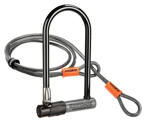
Cable locks are convenient but are also pretty easily defeated so I wouldn't use that as a primary lock. I mean, every lock is going to give up if a determined enough thief goes after it.
I got one of these for my ebike: https://www.amazon.com/Abus-Bordo-Granit-Security-Level/dp/B07921LT3W (folds up pretty small and mounts right on the bike, but it is heavy)
and paired it with a cable / mini-U lock
Here’s a good lock. Should work with a parking meter pole.
There’s a mini version too. https://smile.amazon.com/ONGUARD-45008112-Brute-Mini-Lock/dp/B007HOG61Y/ref=sr_1_4?crid=2PS8OQS8TX9ZA&keywords=OnGuard+brute&qid=1657808358&sprefix=onguard+brute%2Caps%2C160&sr=8-4
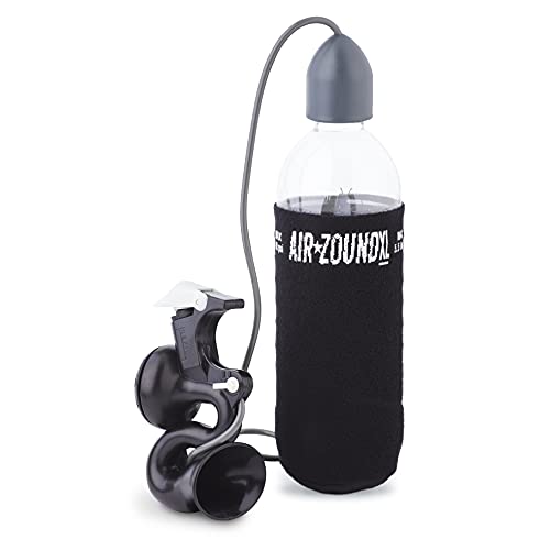
Get this outrageously loud air horn.
It will blast right through their earbuds, through cars rolled up windows, this thing blasts into your soul.
That link was for downtown LA (in case you didn't know, the high temperature is often about 10 degrees higher in the valley and 10 degrees lower by the beaches). Van Nuys gets hotter but in August 2021, if you left by 8 you'd generally be fine.
What time are you commuting to work? It's rarely above 75 degrees at 10am.
on wundermap radar, if the temps/wind is unchecked and [atmospheric conditions] windstream is checked, the prevailing direction shows for the area.
how do you ride a loop with a tailwind most of the ride?
i've never bothered checking because no matter which way i turn i always have a headwind.
Is this the route you’re talking about? Want to try it for myself, never heard of Cogswell Dam. Do you ride it out and back?
You'll be fine on the 710 bike path! There's not a lot of great places to stop until you get to long Beach though so make sure your waters are filled before then. Here's a route I've done that I like from near DTLA.
Also, don't leave your bikes locked up outside anywhere in Hollywood unless you're sitting within sight of them. Just like SF, bike theft is crazy rampant here and takes almost no time at all if left unattended, especially at night. If you can bring them inside or locked on an upstairs private balcony, that would be best.
Strava Activity It's about 8900 gained over 68 miles. I've done a similar ride to the ride you have planned. The San Gabriel Mountains are my favorite place to ride!
This(Cyclistthings.com) site has some growing resources. It includes routes on strava and points of interest on google maps which includes local coffee and bike shops! My favorite route is, by far, Crystal Lake which also has a cafe at the top!
What you’re looking for is a rickshaw!
In all seriousness if you’re looking for an adult trailer I get a sense of the situation you’re in. Perhaps you want to look at something like this, which is trailer for items not people, that you can further modify. Otherwise I’ve never seen a trailer for an adult.
QuietKat Two Wheel Game Cart, FatTire Off Road Cargo Trailer for Extra Storage While Hunting, Fishing, Exploring Backcountry, Three-Way Adjustable Rack Angle (20" x 4" Wheels/Tires), Black https://www.amazon.com/dp/B07QKS9ZB3/ref=cm_sw_r_cp_api_glt_i_HBJV3236G05XNHW6A7KQ
Hello! I purchased this rickshaw to transport my 84 year old grandmother on. It turns out maybe this is not the best way to transport an 84 year old with poor mobility and would be better suited for children or people who are more able. We rode it a half a mile and then back once. It worked okay, but there was nowhere to put her walker. Pedaling is actually not that hard. There are no gears and it has a caliper brake in front and a brake on the axel in the rear. I spent a solid 8 hours plus assembling this thing and it... works well for what it is. I would not recommend this for very long distances -- it is narrow so that it can fit through a standard doorway. I am trying to get what I paid for it since I sunk all that time into installing it, which is $788 plus tax, working out to $869.74. I can also sell you a 15 foot Kryptonite table (brand new) and U lock (not new) for an extra $100.
https://www.amazon.com/gp/product/B098MNHJ5M/ref=ppx_od_dt_b_asin_title_s00?ie=UTF8&psc=1
I use https://www.windy.com/?33.867,-118.120,10 for checking the wind. But yes Santa Ana's provide an atypical wind direction which is advantageous for PRs in some direction.
Neither did I till recently. 27mm is fine for May Canyon, and easily accessible from NoHo.
This loop through the SF Valley is very bike friendly and doesn't have a ton of climbing.
Can't ride this Sunday, but I'm planning to be at the Brand Park gate on Sunday, May 23rd at 8:15 a.m. and roll at 8:30. Probably do this route. No planned water stops; I'm taking 3 bottles.
I had posted about this group ride in a different thread:
The Montrose Ride AKA The Trader Joes Ride, takes place every Saturday at 4 different start times from the same location. The slowest group starts first, and the faster groups starts last. They all end at the same place and because of the staggered start usually end at the same time. This is not a full loop, it's 32 miles from start to finish, and another 10 miles if you ride back to the start. Here is someone else's GPS route, this link doesn't include the ride back to the start: https://ridewithgps.com/routes/1115009?lang=en
Start Location:
Trader Joes, 613 Mission St S, Pasadena, CA 91030. Free parking all over the neighborhoods
Start Times:
7:30am - Slow Speed group (think recumbents and tandem road bikes)
7:45am- Average Speed Group
8:00am- Average/Fast Group
8:30am(?) I think its 8:30, never ridden in this time slot- Fastest Group
Lately the fast riders have been dropping into the slower groups to take it easy, but inadvertently causing those slower groups to go faster. Start with the 7:45 group if you're not sure which group to ride with. Even the 7:45 group can start to pick up and average 20+mph in the second half.
There are no ride leaders, you just show up and start pedaling when everyone takes off at your desired time-slot. If you get dropped you're on your own. Everyone is very nice, so feel free to chat people up and see where else they ride.
The free way really isn't bad on a weekend because you'll be going the same speed as cars.
Here's an approach I did from Anaheim - there are a few spots we diverted off PCH that you might want to pay attention to, especially Gleneyre in Laguna Beach.
My strava is set to private, but feel free to add me: https://www.strava.com/activities/4256843806
If not, here is the RideWithGPS route: https://ridewithgps.com/routes/34531021
The Joe Kelly Mural is off Sunset and Silverlake behind the Floyd's barbershop.
Started on Fern Dell, climbed towards the observatory, went down Vermont towards Vista Del Valle, then took Vista Del Valle to Mt Hollywood to get back around to Fern Dell.
Edit: not sure I explained that well. Here’s the link: https://ridewithgps.com/trips/55222540
You can't ride on Pendleton unless you get a base pass first (or have a valid military ID, presumably). They only issue base passes at the south gate during normal business hours so you can certainly head down there mid-week and try to take care of that first, assuming they're even open in today's environment.
Alternately, just ride on the shoulder of the freeway from Las Pulgas down to Harbor (note that bikes are required to exit for the rest stop 2 miles in).
Here's a route example (also note the difference in San Clemente, I prefer to stay off PCH right there.) And if you go through Laguna, get off PCH and take Glenneyre. I used to ride this route a ton - start at the train station, meet some friends at Gypsum canyon RV park and then ride any number of different routes to Dana point. Grab some pizza and beer in Oside and take the metrolink back up.
Yep! They've got a set of bike paths that total up to somewhere around 30 miles of riding in a loop. Here's someone's map of it from everytrail: http://www.everytrail.com/view_trip.php?trip_id=353749
I like the Three Sisters/Filiorum/Portuguese Bend/Forrestal reserves a lot. They’re all connected. From below, they’re between the Trump golf course and Terrenea off of PV Dr S. From above, they can be accessed by Crest Rd off of Hawthorne or Crenshaw. There are tons of trails in there, but many are closed off to bikers. The soil there is very different from the Boundary trail. It’s basalt and schist. Hard packed when dry, but turned to sand when the horses get to it. Super sticky in the wet and the reserves are closed when it rains and until the soil dries.
Your ride here basically circled the Malaga dunes. That area is pretty fun. Also lots of trails and there’s some fun BMX/MTB features built up in the East end.
I also like the Blufftop Trail which hugs the cliffs from Bluff Cove to Lunada Cove.
Two really good trails that are a bit too technical for my CX bike are the Apsley/Douglas trail and the Lunada Canyon trail. I still like to take my CX bike there because, hey, good practice dismounting/remounting and running lol! Well, walking if I’m honest. These two trails also have very little traffic. I’ve had stretches of weeks hiking or riding them where I never see anyone else.
All of these trails hook up to each other nicely. Even between Lunada Bay and the Three Sisters reserve, there’s a dirt path along the coast. I’ve always wanted to use it, but every time I ride by, I see people walking on it and figure it’s too much of a bother. Just stay in the bike lane until the reserves.
Foxen Canyon Road near the Fess Parker winery is always a good little climb with some lovely views.
This loop covers most of it. I'd do clockwise instead and have a nice meal in downtown Los Olivos near the end.
I think I'll just do the 70mi because the century does a silly up-and-back turnaround on the 605 River Path. I'm volunteering by routemarking the day before which includes a free registration so I'll decide then!
You can see last year's routes here: https://ridewithgps.com/events/lariverride#routes/8596463/preview
- I try to avoid yelling or cursing at pissed off drivers (who are very rare as I stay away from bike-unfriendly streets). No minds are going to be changed, and they like getting a reaction.
- I always carry pepper-gel (but have never used it).
The Granit looks interesting I'll check it out:
​
I didn't realize that insurance companies rate your locks. I have renter's insurance and they didn't mention anything like that in the terms.
I learned a lot by reading this book at home.
Park Tool BBB-4-Big Blue Book of Bicycle Repair, 4th Edition, by Calvin Jones https://www.amazon.com/dp/B07QPVZ932/ref=cm_sw_r_cp_api_glt_fabc_8NF56PQWZYNXRDZSV7VK
For things I didn’t know or just wanted someone to tell me (because I was lazy) I went into the Bike Oven.
Bike Oven https://goo.gl/maps/dcNmAjRCw37pvPys9
In the end I found that by buying a bike stand and accumulating tools slowly I was able to do better job faster than going to a shop.
However, If you are looking to buy a new one, I can recommend the speedsleev as a saddle bag or the handlebar/frame bags from lead out. They have water bottles too and are based locally
This front light has never let me down. The lower flashing setting lasts for like 6 hours. And then when you 'need to see' just kick it up to a solid beam.
Don't recommend the "hot shot" rear from Cygolite. It's flimsy and doesn't mount well. Also when it flashes the brightest, it's literally too bright. Blinding to other cyclists.
Rear lights are all about 'being seen' so they don't have be aggressively bright. They just have to draw attention. This is my most trusted rear light.
https://www.amazon.com/dp/B00OACI5PQ/ref=twister_B00D42FYPM?_encoding=UTF8&psc=1
The gel straps mount securely to the seatpost or your chainstay. Again, good modes for brightness and the low flashing setting is plenty bright, and lasts for like 9 or 10 hours.
I bought some neck gaiters on Amazon (not this brand but similar) because it’s getting cold. I feel like it’s easier to breathe with them on because they’re super thin, even though that’s not what I originally got them for.
Many cyclists carry this pickle juice. It's supposed to instantly make cramps go away. I haven't tried it, but many say it really works!
Also, I've heard others mention mustard. Go into 7-11 and get a mustard pack from the hot dog stand.
I got this cover last year for my bike.
My last apartment, I kept it on the balcony. I didn't ride it much last summer, so I just let it sit out there. It didn't rain, of course, but it got very dirty. This cover kept it dust-free and dry during the winter rains.
My current apartment's balcony isn't actually big enough for my bike, so I keep it indoors now. I guess I don't actually need the cover anymore...
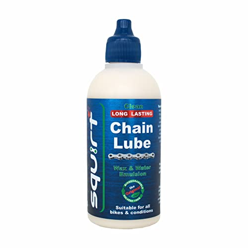
I prefer dry lube... More of a wax. I use Squirt but you have to make the chain VERY clean and free from previous lube and gunk before putting it on. The lube is very long lasting and doesn't attract much gunk since it's more of a dry lube
I've been using this handlebar mount (Satechi Universal Holder & Mount, currently $9) with a couple different iPhones for years now. It's sturdy and works great. Comes with a thick rubber band (more like an o-ring) that locks the phone in place as a safety (which does cover a smidge of screen, but it doesn't bug me). I wouldn't use it without the band, I had a phone pop off a previous handlebar mount and skitter across a street.
I only use Apple Maps for driving because Google and Waze go for the more circuitous routes and also like to make me attempt left turns at uncontrolled intersections onto super-wide major arterials. But for biking Google maps is the way because it actually deigns to attempt to generate bike routes.
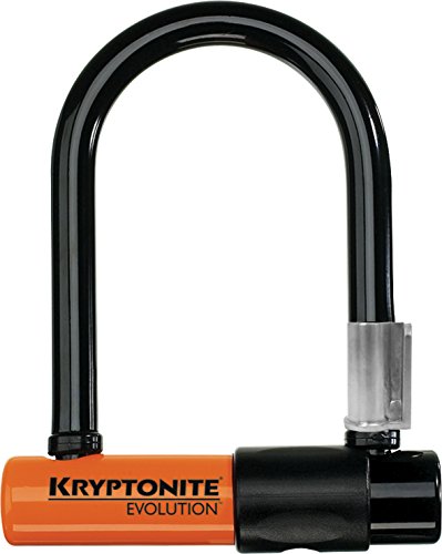
Unfortunately, this is actually a fairly easily defeated lock despite the looks of it:
:(
I'm not in LA but came across this post while searching for a Caviar courier subreddit(looks like it doesn't exist yet). Would this work for your bike and budget?
http://www.amazon.com/Origin8-Classique-Cargo-Front-Rack/dp/B00B135SSE
Add a heat bag, bungees(I prefer the flat kind).
The map routing situation can be dealt with some MacGuyvering or with more expensive fixes. I have this flattish seat bag that I used to keep spare tubes in; now I have it MacGuyvered onto one of the straps of my backpack. I stick my phone in there instead of a pants pocket. I turn the app volume all the way up and can hear Gmaps routing(if I need it) through the din of NYC traffic.
Bluetooth earbuds, as already mentioned, will work. Small portable BT speakers(that you can somehow attach to a backpack) will work. If you must have the visual map to look at, maybe the mount is your only option..
that sucks :(
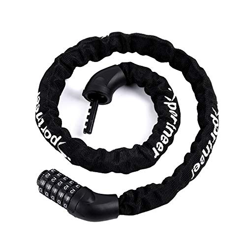
I recommend two Evolution Mini 5's ( http://www.amazon.com/Kryptonite-Evolution-Mini-Bike-U-Lock/dp/B000AMPRG0 ) and these: http://www.amazon.com/Two-Fish-Lockblocks-U-Lock-Mount/dp/B001P9EWKE