
What are
/r/seattlebike's
favorite Products & Services?
From 3.5 billion Reddit comments
The most popular Products mentioned in /r/seattlebike:


The most popular Services mentioned in /r/seattlebike:
Ride With GPS
Strava
OfferUp
AllTrails
The Weather Channel
MapMyRIDE
Komoot
Gumroad
Windy
The most popular reviews in /r/seattlebike:
There's a lot of great routes in here: https://ridewithgps.com/organizations/29-seattle-international-randonneurs/routes
​
Just filter by <80 miles and sort by location. Lots to take a look at!
If you want a fun challenge you could take the interurban up to Mukilteo, cross on the ferry, follow half of this route, cross deception pass, and then continue north on the RSVP route to Bellingham.
[edit] fixed link
Stay away from the burke if you want a good ride. From Kirkland you can do SO many good rides, Go out to Snohomish, go out to Bothell, Cherry Valley, May Valley. Cougar Mtn. Why spend the day on a bike path dodging dogs, strollers and cops? This is a random ride that I picked. Ignore the logboom start, and tailor it to your starting point. https://www.strava.com/activities/370195
My personal ride would be Kirkland: Redmond > Hollywood Hill, Woodinville Duvall Road, Right on West Snoqualmie Valley Road, Left on Ames Lake/Carnation rd, Left on 203, right on Stillwater/Kelly and drop down through Cherry Valley to Duvall. Then head back up either Novelty Hill into redmond or through Woodinvill Duvall Road to Kirkland.
Sorry for the spelling, it's late.
I like doing the Mercer Island Loop (about 13 miles) after work. I generally prefer clockwise, the shoulders are better. It's hilly enough to get a decent workout in a short time, plus the roads are very biker friendly.
Just yesterday I did the Lake Washington Loop (about 50 miles). A few large hills and lots of cool scenery.
As far as trails go, you can hit the Burke-Gilman/Samammish River, The Interurban, or the Centennail trail. On nice days they can get a bit crowded though. This is a good option if you don't like riding in traffic like me (too many /r/WTF videos of people dying I guess).
I'm a fan of using the Centennial Trail and SR-9. I've done both the Chuckanut Drive (RSVP) and the linked route, and have enjoyed them both for different reasons. If you want to reduce traffic encounters, however, the Centennial Trail and SR-9 route might be the better choice.
This route is worth considering! A lot more interesting in the second half especially. Hwy 30 kinda sucks so it’s nice to have an option to get off it. You can find video of the ride here too!
about 5 days a year we get more than 1 inch of rain - but there is measurable precipitation on something like 152 days. we get 37 inches of rain a year on average - NYC gets 50 inches but they have something like 300 days with no precipitation.
buy a good raincoat. buy neoprene booties (but you'll still get wet feet.) good gloves and a helmet cover are recommended. rain pants are optional.
https://weather.com/science/weather-explainers/news/seattle-rainy-reputation
Check out the STP route, its pretty close to what you mapped out. https://ridewithgps.com/ambassador_routes/1217-seattle-to-portland?lang=en
When I did the two day ride a few years ago we stayed at GWL as our halfway point.
This should do what you want, but I'd recommend this instead to avoid the very steep Lake Alice Road and a narrow staircase at the northwestern end of the Reinig Bridge.
EDIT: There's a set of narrow gravel switchbacks supported by retaining walls in the first route that will most likely result in a hike, as /u/bumpitysnook mentions below.
I do a loop similar to this a lot, and mix it up in various different ways!
A recommended deviation to your posted route that avoids downtown and SLU and spends more scenic time along the water. Assuming clockwise, but works the other way in reverse, too:
Keep going all the way down to the water front from the ID (down King/Jackson) and take Alaskan Way to the Elliot Bay Trail. Keep on EBT until 20th Ave/Gilman Ave in lower Magnolia. Hang a right on Emerson and catch the Ship Canal Trail to the Fremont Bridge.
Here's roughly the route as I'd recommend it: https://ridewithgps.com/routes/32897911
Some more variations on that same loop to get some more climbing in:
Include a loop of the Magnolia Bluffs and Discovery Park in between the Elliot Bay Trail and the Ship Canal Trail
Keep on LWB all the way south down past Seward Park, cut west on Othello to the Chief Sealth Trail heading north up Beacon Hill, through Jefferson Park, and eventually catch the 12th Ave/Jose Rizal Bridge back into the ID.
Instead of the Montlake Bridge, take the University Bridge and cut up Interlaken, either via Harvard Ave or Boyer/Delmar for a nice wooded climb to north Capitol Hill, and cut back east to reconnect with the Lake Washington Loop trail in Madison Valley or the Arboretum.
You probably already have a route, but if you're feeling adventurous, you could take Jan Heine's route over Babyshoe Pass. It's on my short list for this summer.
RWGPS link (I think this is maybe not exactly the same as Jan's but bikeroutetoaster seems to be down)
If you have a gravel capable bike, the Iron Horse / John Wayne Trail is a viable option. Frequent, affordable and secluded camping spots along the way. You can take the I-90 trail and bike-friendly roads to North Bend and start the trail there. US-97 has a wide shoulder on this route once you get on in Cle Elum.
​
I'd suggest at least 28mm tires if you're unfamiliar with the John Wayne Trail.
​
I've ridden to Leavenworth before over US-2 on a road bike. There were a couple of spots where you could hop on the Old Cascades Highway, and without snow at the pass, the whole chain-up lane was nice and wide open, but there really aren't any other paved options over, unless you want to go over the Snoqualmie Pass and head north from there.
If you're okay taking dirt/gravel roads, I've taken one of the dirt Forest Service roads by car like 40mi from around Index to Wenatchee. Very rough road, lots of elevation; doable, but not on a road bike.
EDIT: Here's the link to the route I took to Leavenworth on my road bike.
as long as you don't mind a hill or two this is a good route:
https://ridewithgps.com/routes/27552827
(an adaptation of the old Clyde Hill option from the Bellevue bike map - it's signed most of the way.)
One of the advantages of the whole course is that it's very compact; you can ride part of it pretty easily and it's easy to find places to get extra water.
The full course is here
This fun forest road climb convinced me to get a mtb. The climbs aren't tricky but the descent was exhausting on the hoods of my disc trucker.
https://ridewithgps.com/trips/17602945?privacy\_code=G4ROZYDB3uxWiXbX
Next time I head that way I'll explore more forest roads, it's real pretty up there. I'd do it again on a road bike if that's what I had, but it's a little more fun on the mtb.
I primarily use RideWithGPS.com to map my rides, it is pretty basic which I like. It will also put you on trails rather than roads. I know Google does something similar, but I just find it clunky. While riding I track my rides while riding with Garmin/Stava so I have a record of my rides.
Regarding finding your way around... unless you regularly take back roads riding your bike can get frustrating. I know how to drive from my how to Renton, but when I first started biking I would get turned around confused. It takes awhile, but eventually you have your own mental map built up just like you do in your car.
Centennial Trail is pretty fantastic. 30 miles in one direction with stops signs few and far between and hardly the usage you get on the Burke.
I think the speed limit might still be 15mph, but with the limit usage it is not nearly as big of a deal as the Burke.
FWIW I ride from Kenmore to Marymoor and back regularly during the week and usually avg about 18mph. It is much less crowded weekdays. If you want to extend that ride just keep going around Lake Sammamish. I would highly suggest going counter clockwise around the lake though as West Lake Sammamish has a bike line in that direction. East Lake Sammamish has a should going both ways.
Here’s another route to consider: https://ridewithgps.com/routes/29656323
It is a really lovely route that I’ve done before and has minimal time on the state highway. Probably not the most direct but quite scenic.
You can cut out the top portion and just cut over to Fort Casey in the middle.
I don't think there is another option unless you took that road that runs parallel to highway 3 and that most likely has zero shoulder, but looking at the strava heat map people do that and highway 3. If you wanted to take the ferry from Seattle over to ride that area then going on the Southworth ferry is the better option.
Here is the route from the Narrows bridge for route/road ideas.
Here is a route out of Bremerton, I've never done this ride so can't comment on it.
don't know why I didn't think this when I saw your post - from Centennial Park in Snoqualmie to the end of the pavement the middle fork Rd. is 20 miles and the grade is pretty consistent all the way.
it's not 20 miles, but this little loop is fun and the first 8+ miles are a very consistent grade
I did an overnight a couple months ago on the Mountain Loop Highway. Started from Granite Falls and rode up to Barlow Pass and camped in one of the first come first served spots on the side of the loop. Next day I rode into Darrington and then on to Arlington on the Whitehorse Trail. I was lucky enough to have someone pick me up there. Day 1: 33.2 miles and 2,471 feet of climbing. https://ridewithgps.com/trips/49649270 Day 2: 49 miles and 808 feet of climbing. https://ridewithgps.com/trips/49668960
I rode 67th Ave last Saturday. https://ridewithgps.com/trips/53248898 Its around 0.8miles. I would describe it as Dyatlov-y "Not great Not terrible" but I imagine it really depends on the time you ride through it and your confidence on the bike. It is flat and the cars were fairly respectful. I cant speak to the 8 miles of shoulder(?) of Highway 9.
Good Luck! Safe travels! Drink a brew from Aslan for me!
Head south out of Issaquah on Issaquah-Hobart Rd past May Valley Rd, take a left on Tiger Mountain Rd SE and go up the hill, you can access whats called the "West Side Rd" on MTB project and take that over to the Tiger Summit lot and start of the loop. Probably more pavement than you want (about 5 miles) but there's not a good way to get there on the north side and I'm of the opinion that the I-90 side of tiger is more for hikers and bikers should stay where all the bike trails are by HWY 18
There are MILES of trails that can be made even longer if you do a bit of research and know how to connect them.
A couple of my fave rides:
- Lake Sammamish Loop - I used to do this clockwise but switched after I realized Southbound W. Lake Sammamish Parkway has a bike lane.
- Lake Washington Loop - A nice combo of trail and reasonably protected roadway. Some nice hills without being too killer. If you want to shorten just cross I90 and eliminate either the southern or northern portion, just have a plan for Mercer Island, I swear I always get lost.
You can also link Lake Sammamish with the Burke via the I90 trail which has a big hill up and over Factoria.
The interurban is a great connector trail as well. It isn't great for getting through Seattle, but it travels north all the way to Everett and South all the way Auburn.
We live in a great area of cycling! Go explore! My 'best' training rides have been taking off from home and meeting people somewhere. I have ridden to Anacortes, Snoqualmie Falls, even Bellingham and met with family for the rest of the day.
Like was already said, you can keep going past Bothell on the Sammamish River trail (the Burke turns into it) all the way to Marymoor Park. It is pancake flat the whole way.
From Marymoor Park there aren't any really truly "flat" ways to get to either 520 or I-90, at least not by the same definition of flat like the Burke-Gilman or Sammamish River Trail. The Bellevue area between 520 and I-90 is kind of one large-ish hill no matter which way you slice it. Mercer Island and the I-90 bridge are also not "flat", but aren't terrible hills.
From Marymoor Park you can take the 520 bike trail to North Bellevue which is a bit of a chug but not too steep. Then you can cut South through Bellevue to the I-90 trail across Mercer Island back into Seattle. Nice thing here is that you are on bike paths, bike lanes, or low-traffic roads most of the way except for the brief hop across the 405/520 interchange. The route I would follow doing that is roughly this, almost exactly 50 miles: https://ridewithgps.com/routes/15411390
Another alternative is to keep going south from Marymoor Park along West Lake Sammamish Parkway, which is a pretty decent road to ride on. It's a bit rolling until you get to the south end of Lake Sammamish, at which point you've got to chug up to the top of Eastgate, which is really no better or worse than the 520 Trail/Bellevue route. Ends up being a few miles longer, as well. I've roughly outlined it here: https://ridewithgps.com/routes/15411502
As others have said, the Burke Gilman and Sammamish River trails are great for long distance rides but can get boring relatively quick since they are flat.
I recommend doing a loop around the south end of Lake Washington plus doing a loop around Mercer Island. Gives you a challenge of rolling hills and goes through some nice places. You'll get to go by Gene Coulon beach Park, see the Boeing factory, take a break at Seward Park, take a quick pic at the I90 Vista, and then enjoy the mercer loop. Here is the route I took a couple of weeks ago https://ridewithgps.com/routes/12238891
I don't regularly ride the BG but I have ridden the dark sections at night. I run a Light & Motion Viz360 on my helmet and a $35 Chinese LED from Amazon on my handlebars.
Whatever you run pay attention to where the beams are aimed down so they are illuminating the trail and not blinding oncoming traffic. Flashing/blinking/strobing headlights are not a legal option for bicycles in Washington. Only red LED taillights are allowed to blink and you still have to have a rear facing red reflector after dark.
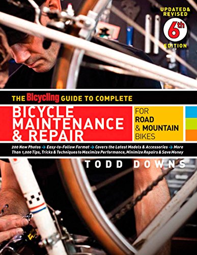
Sheldon Brown is like bike maintenance jesus. The website is dated but the info is not. https://www.sheldonbrown.com/beginners.html
I recommend the park tool videos already linked. Calvin Jones also wrote the big blue book of bicycle maintenance. I bought that when i was first starting out.
The book above may be just a touch advanced unless you're really interested in nerding out. i found this book to be pretty helpful for basic stuff (but be warned, occasionally it will say to take your bike to a shop...which is good advice but not always what you want to hear) https://www.amazon.com/gp/product/160529487X/ref=ppx_yo_dt_b_search_asin_title?ie=UTF8&psc=1
You can also post in r/ bikewrench but the mods there are pretty quick to ban anyone that tries to have a good time while learning. The people in /r/bicewrench are cooler and if you ask for actual help you'll get it (probably from me), along with some gentle ribbing.
other good youtubers include RJ the bike guy and sometimes the dudes at GMBN Tech put on a good episode.
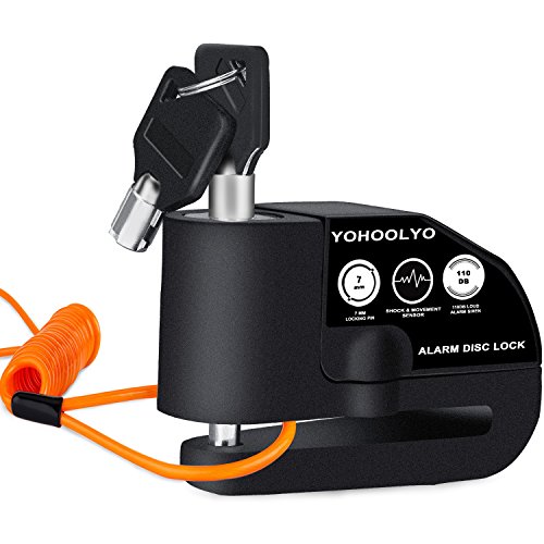
This is what I have. No idea if it’s better than the others but it’s very sensitive and extremely loud so I imagine it would be a decent deterrent.
Funny enough I just got my card for a bike locker and definitely intend to use it at the station. I have left my bike @ Northgate on the open bike racks and it was fine, there seems to be a good amount of observation/security there, but once I get my card it will put my mind at ease.
YOHOOLYO Alarm Disc Lock Motorcycle Disc Brake Lock Anti-Theft Waterproof 110 dB 7mm Pin 5ft Reminder Cable for Motorcycles Bike Scooter Carry Pouch (Black) https://www.amazon.com/dp/B01M4MG0YT/ref=cm_sw_r_cp_api_glt_i_BVMP1V8BSW48GCVED5WA?_encoding=UTF8&psc=1
Ravenna park has a pretty short dirt/gravel trail (1.5 miles?) that I tack on to a longer ride on pavement. Doesn't really require CX though. I've done it on slick tires.
https://www.alltrails.com/trail/us/washington/ravenna-park-loop-trail
This is it. I've loosely mapped out a version here in RideWithGPS: https://ridewithgps.com/routes/37517184
I added in the Cross Kirkland Corridor, as that kinda counts as gravel. You can add in Redmond Watershed for some extra single track-ish fun too.
The Lake Washington Loop is super picturesque 60 miles, but you can probably cut it in half by biking across the 520 or the 90:
https://www.alltrails.com/explore/recording/lake-washington-loop--18
here are some to get you started
The flattest century around here is the loop from Arlington to Darrington to Concrete and back to Arlington - it's a great ride and only about 2,800 ft. in the full distance
There’s lots of gravel in the Snoqualmie Tree Farm, the privately owned logging land between North Bend and Sultan, east of Carnation.
This is an example but you can avoid pavement altogether (not go through Carnation).
https://ridewithgps.com/routes/29686223
I think the gravel riding crowd must be on Strava because I’m not finding much on RWG offhand.
You do need an access permit — it is sometimes patrolled especially at the southern access (Spur 10 gate off the North Fork Road).
One that I've always enjoyed doing is this loop. You have a few options between Enumclaw and Black Diamond, but I'd recommend steering clear of the SR-169 bridge across the Green River.
This is the route that I like to take from Seattle to Tacoma. There is a steep winding hill just out of Algona. No cars and a couple of barriers to crawl over/around but it’s worth it.
How about something like this? Pioneer Highway hasn't given me too much trouble as long as I start my day early, but avoiding State Street/Smokey Point Boulevard is something I always try to do.
I took a look at RidewithGPS and these two are promising based on my experience on the east side.
This one hits all the trails in Redmond city limits. And this one hits the Sammamish River Trail and Cross-Kirkland Corridor. The corridor is gravel but really hard packed from what I remember. Easy enough on a road bike.
One of the frustrating things for me is that when I started this project, this was a free feature of Ride with GPS. Now it's only part of their paid membership.
The ridewithgps.com route planner has an option to highlight bike paths and lanes. In combination with satellite view, I find I can avoid most road that are shitty for bikes.
From Greenwood I head up the Fremont (and a little bit on the Interurban - but I have been trying to avoid trails for the most part these days), then cut over at 160th, past Shoreline CC, through Innis Ardin, Richmond Beach, and Woodway. Pretty nice roads, good views and little traffic. Route here: https://ridewithgps.com/routes/32730749
this one is a real good ride - with a lot less elevation that Stevens Pass.
[here])https://www.obatik.com/stories/biking-stories/trail-descriptions/selected-rides-across-the-520-bridge/centuries-across-520/) are a couple other personal favorites.
OOh, awesome, thanks for sending! That's actually the part I'm least familiar with so that's perfect.
I followed this route (RSVP Day 1 rough route) https://ridewithgps.com/routes/12326403
It was an amazing ride on bike trails the first half. The second half was much more on the road sharing space with cars so was a bit stressful. I did it 1 way and then stayed in anacortes, but would actually recommend going half way out and back to get the century distance with less logistics and more trails :)
Thanks! I haven't gotten the hang of using rwgps quite yet, but I was referencing this route for the Maple Valley portion and strung it together with South Lake WA, which I've done a few times, and Magnolia, which is a pretty regular loop I do. Sorry I can't be of more help!
Would love to check out that Sea-Anacortes route if you have it though!
For shits and giggles I stitched together the 4 most current segments from the ODT RideWithGPS and created a single route GPX. It has all the cuesheet entries as well as detailed GPS trackpoints.
Here's the GPX if your device supports that format: https://gofile.io/d/MpabjH
Unfortunately, RideWithGPS ignores GPX rte cuepoints on upload, so I cannot recreate the cuesheet on RideWithGPS.
And here's the route, minus all cues: https://ridewithgps.com/routes/32594464
One cool option is to take the Bolt Bus up to Bellingham and ride back. It would be closer to 120 miles though.
I followed this route a few years ago. Here is a similar route. Cheers!
Made a slightly easier, but longer one ;)
https://ridewithgps.com/routes/32545238
Adds 14 miles (what's a little more distance?) but saves you some climbing, and has a lower maximum grade.
Also! Get to pop in Snohomish Bakery (assuming they're open) for a tasty treat 40 miles in, then enjoy a (very) long stretch of farmland riding down past Carnation (do stop in at Sandy's Espresso in Carnation around mile 65!), and loop back to Redmond (avoiding the nasty Duthie Hill and Tolt Hill, ugg) before finishing via the BGT.
What's especially fun is that the hills are basically front-loaded, and it follows the Interurban North route. Leave early and you'll have it entirely to yourself. Once you get out past Snohomish there'll likely be few other folks until you get back to Redmond.
​
[edit] looking online, it might be that some of the off-road trails this route uses are closed :x. There's street options abounding, but boo.
You might do something like this: https://ridewithgps.com/routes/32526243
I could probably come up with a route that has less climbing, but who wants to go back and forth on the same path over and over?
This takes you south along the Duwamish River Trail to Tukwila, cuts over to Renton for the beautiful Cedar River trail then circles back to Issaquah via Poo Poo Point. Then up past Lake Sammammish, continuing north up to Mill Creek / Paine Field, and then returns via Lynwood to the BGT for the lazy route back to downtown Seattle. 100.5 miles :)
The only section *not* through an urban area is from Renton to Issaquah, but those roads are pretty well traveled and you're likely to find someone to help in case of an emergency.
The hills are mostly low grade, so shouldn't be too bad. Going further south isn't super fun as the North-South hills mean you pretty much have to backtrack to avoid a major grade.
In Ride With GPS you could try typing in "Seattle Century" into the search and looking through rides others have done. This one seems pretty promising and more interesting than looping.
Yakima Canyon! This is the time of year for it and with traffic down the road will be a lot more fun.
More generally, have you reviewed Ride with GPS? It mixes commute routes in with recreational rides but all of the popular stuff is there....
How about North Shore Road? It's more a segment of a ride than a complete ride, but you could combine it with other riding in the Tahuya State Forest like /u/theguth said.
My suggestion if you are renting from Evo. Just about 100% trail, though a little longer than you are looking for. 520 bridge is great on a nice day!
In shoreline you could hop on the Interurban trail and ride it north for as far as you like, as an out and back:
https://ridewithgps.com/routes/17553016
The full trail is like 48 miles round trip. All paved, fairly flat.
So, if I were to design a route for someone looking to do 50 miles in Seattle and see many of the best sites to see by bike… this is what I would suggest to them! (Beginning/leaving from Montlake Bike shop!)
This includes:
- The Ballard Locks (Gotta walk your bike through there, but it's cool!)
- Discovery Park (old military base with a SUPER fun descent and great views!)
- The BNSF "Hump Yard" (you might see some unfinished 737s on train cars waiting to be delivered!)
- The Waterfront park, including the sculpture garden and views of the Olympics
- Pike Place Market
- Alki Point (and some of the industrial docks on the way down — Marination Ma Kai is a Hawaiian Fusion restaurant at about the 21 mile mark that has an outdoor patio with views of downtown and space to stash your bike while you have a beer and spicy pork or "sexy tofu tacos"!)
- Alki Beach and Lincoln Park — more views and water!
- …then a little bit of a climb and trudge back over to…
- The Duwamish River, and passing by the Duwamish Longhouse and Cultural Center (the Duwamish are the native people of Seattle)
- Crossing through Georgetown (another beer spot, also a great Pinball Bar, Flip Flip Ding Ding!)
- Pass by Boeing Field, check out all the random Livery on the jets awaiting delivery, and maybe some weird military hardware
- Climb up to the Chief Sealth Trail (namesake of Seattle), a rolling greenway powerline trail
- Roll through Jefferson Park for top-of-the-world views of Downtown and the Industrial District
- Head over to the José Rizal Bridge for an awesome view of the stadia and downtown, with the highways snaking through it all
- Hop back up to the I-90 trail to take you through some nice parks and the bike tunnel over to…
- A super fun, hairpin-turn-y-descent to
- Lake Washington Boulevard!
- Take in some lakeside views on the return trip to Montlake.
If you don't have any plans such that missing a ferry and pushing your schedule back an hour would be problematic, I find hopping on the ferries to always be an enjoyable experience. One of my favorite ~50 milers is over to Bainbridge Island, through Suquamish to Port Gamble, out onto the Hood Canal Bridge just to say I rode to the Olympic Penninsula, and looping back through Poulsbo.
here's a variation on Yoderman's route that cuts through the high school parking lot and through the boeing parking lot to tukwila station - this is a good route that I ride a lot and that I've ridden recently
Ride this route all the time. My recommendation is here: https://ridewithgps.com/routes/29350062
This provides the most bike travelled routes, protected bike lanes in sections.
Have fun! Be on the lookout for distracted motorists! #gobybike.
ahh okay. That sounds like fun. And yeah that's my plan. Since I haven't done much bikepacking around here I'm keepin' it easy.
My intended route: https://ridewithgps.com/routes/14785037
Except starting from capitol hill
Glad you like it! There is a bike lane for most of it except for the road along Seward, which is a shared road. There aren't too many cars and the speed limit is low since it goes along the waterfront. The busiest part of the trail is probably Logan Ave but it has a bike lane, and it leads into a trail that goes around the Boeing factory.
If you only have time for one I recommend the south Lake Washington loop, simply because there are more things to see. I do the Sammamish River trail pretty frequently but only to rack up the miles. We usually start at Marymoor Park, which is awesome by itself, and head north. I would say the most memorable spot would probably be Redbook Brewery but it's not that far.
Oh that reminds me, a loop around Lake Sammamish is really nice too. Here is the route I take, which is the same as the yearly Flying Wheels route. https://ridewithgps.com/routes/9328983
Stay warm! Cycling caps under wool beanies are the way to go. Gaiters and wind resistant bananas. Fleece lined wind resistant pants and jackets. Waterproof socks. All of these keep you going.
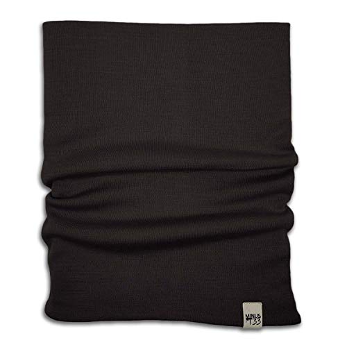
My go to for winter wear is the minus 33 merino wool gaiter for the neck. I'll share a bunch of links for warm wool stuff below
Minus33 Merino Wool 730 Midweight Neck Gaiter https://www.amazon.com/dp/B0047D248C/ref=cm_sw_r_apan_glt_fabc_RC6MAZWHBB5PA8JFKM1B?_encoding=UTF8&psc=1
Same brand has some nice beanies that are thin enough to fit under helmets.
These gloves are the way to go. You will stay warm with wool even in wet weather.
Hot Shot Men’s The Sentry Wool Fingerless Pop-Top Mittens – Oatmeal, Insulated for Cold Outdoor Weather https://www.amazon.com/dp/B0057XA2KS/ref=cm_sw_r_apan_glt_fabc_Y5EPX9DGZ458F9HGNMHV?_encoding=UTF8&psc=1
I use NEOS overshoes which go over the sneakers I use to ride https://www.amazon.com/gp/product/B000MPLLU6
I make sure the tops of these are under my rain pants and my feet stay bone dry. On days when it only rains one way I just knock the dirt off and stash them in my pannier.
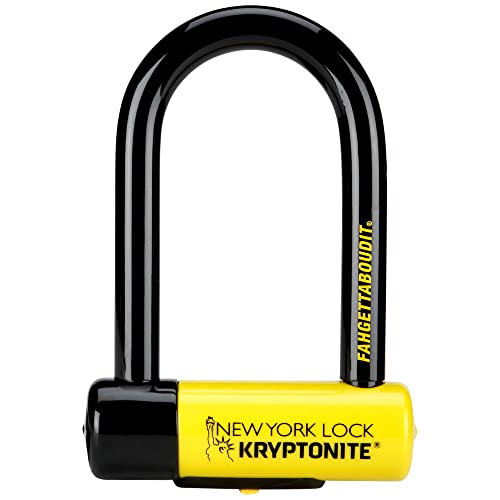
https://www.amazon.com/Kryptonite-York-Fahgettaboudit-1415-Chain/dp/B001SMUB7G
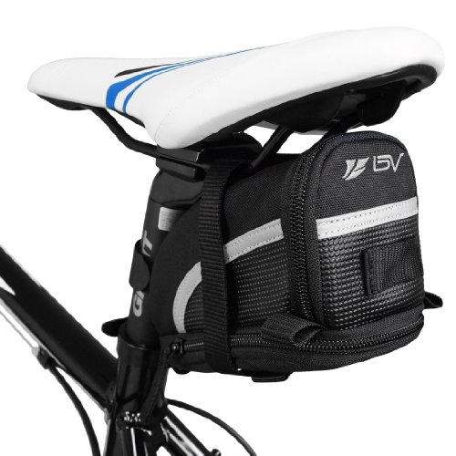
Backpack or if it’s a short ride I’ll have it over my shoulder. If I didn’t care about my frame I’d just wrap it around the top tube
Hey y'all, went down to snag my bike from my apartment garage this morning and the bike racks had been dismantled and my Giant has been stolen.
It's got bright green Kona Wah-Wah pedals and a pair of black pro bike tool water bottle cages https://www.amazon.com/dp/B017RPEXLC/ref=cm_sw_r_cp_apa_i_nUiJFbX7D7MVB
If anyone sees anything leads would be greatly appreciated. This happened in the past 48 hours but I don't have an exact idea of when.
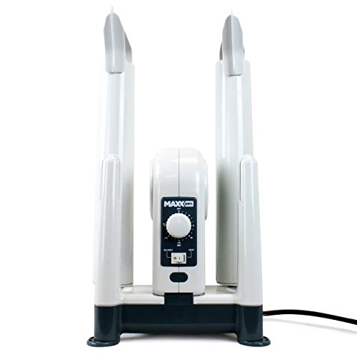
A shoe dryer. I'd never heard of shoe dryers before I moved here (from Los Angeles), but they've saved my life. I have this four-shoe stand dryer at home (fantastic for hiking boots, soggy shoes and socks from chasing my dogs around in the rain, etc.), and used to keep a pair of portable in-shoe dryers in my locker at work, before I went all-remote.
Also:
Dynamo lighting
Hydraulic discs
Yeah, like other people are saying, don't try to keep dry, try to keep warm. I have a long-sleeve wool thermal layer I put on under my jersey on cold days, and a thin rain shell I put over everything to help the rain slide off. Also, a warning about gloves: I also have a pair of Shower's Pass gloves that are fine for most of fall and spring, but on really cold, wet days they're not enough for my 40-ish minute commute, and once your hands are painfully chilled in cold, wet gloves, it really sucks. I eventually upgraded to these, which have served well enough the last couple of winters.
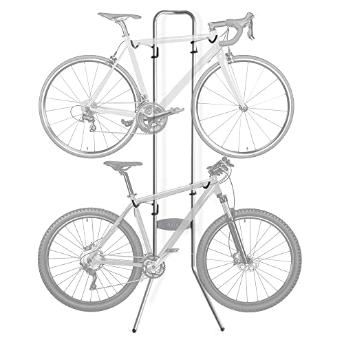
Those lean against the wall style bike hangers work better than I expected they would. We keep both our bikes in the entryway to our apartment and they barely occupy any space.
We got this one for $50.
You should check out the various rides Cascade does every year. There's bound to be some good options for you.
As for padded shorts I don't wear them for any rides under 20 miles in one direction (so never on my commutes or around town stuff). There's no getting around the fact that they kinda look like you're wearing a diaper. But for longer rides, you'd be crazy not to. I've never been stopped from riding longer because my legs were tired, it's always been because my ass was sore.
I'd recommend checking these out. They're cheap and have great reviews. I got a pair and they do the job just fine. I'll definitely be wearing them on the Seattle to Portland ride this weekend (with the aid of some sham cream).
These are the gloves I bought for this season and I've ridden in them in the 20s multiple times for about 30 minutes at at a time and have also done a 35 mile ride in them at little below freezing and they've done the job really well. They run a little small and the supposed touchscreen friendly finger tip doesn't work for shit, but I didn't buy them for that feature, so whatever.