
What are
/r/hiking's
favorite Products & Services?
From 3.5 billion Reddit comments
The most popular Products mentioned in /r/hiking:


The most popular Services mentioned in /r/hiking:
AllTrails
EveryTrail
Outdooractive
Komoot
ConsumerReports.org
Google Maps
TripAdvisor
Strava
Meetup
Garmin Connect
Medium
ipernity
OpenStreetMap
Flickr
Wikimedia Commons
The most popular Android Apps mentioned in /r/hiking:

GPS Logger for Android

GPS Test

MapFinder
BackCountry Navigator TOPO GPS

SAS Survival Guide
Planimeter - GPS area measure | land survey on map
BackCountry Nav Topo Maps GPS

Run with Map My Run
All-In-One Offline Maps

山と高原地図
AlpineQuest GPS Hiking

Gaia GPS: Hiking Maps, Topo Maps, Hike App

Map My Hike GPS Hiking
Ultra GPS Logger

Hiking Project
The most popular reviews in /r/hiking:
Northern California. This is the trail i went on yesterday and today, this is the one i hope to go on very soon.
I got this one: https://www.amazon.com/gp/product/B01NBU7XLH/ref=ppx_yo_dt_b_search_asin_title?ie=UTF8&psc=1
I actually have both the large and the medium, the large is good for big 4-5 log bonfires, and the medium is good for casual one log at a time fires. We mostly use the medium, and it folds up small enough to just live under the seat in my truck full time. I thought the mesh would be a problem but once the fire's going I think it actually helps, because it can draw air up from below. Amazon says I bought it in 2018 and I estimate we've used them 20 or so times since then and it's showing no signs of critical failures.
Here's a sense of the amount of wood we put through it on a typical trip too.
Awesome! Exercise and nature are a powerful combination. Relevant and recommended: Spark: The Revolutionary New Science of Exercise and the Brain by John J. Ratey
For those asking here is all the info you would ever want for this hike/area. https://www.alltrails.com/trail/us/new-hampshire/mount-lafayette-and-franconia-ridge-trail-loop
Cable Mountain Trail in Zion NP.
Three ways to get to Cable Mountain - strenuous hike up from the Weeping Rock trail head accessible from the Zion Shuttle busses (15 1/2 mile roundtrip, elevation gain > 2000ft); slightly less strenuous hike from the East Entrance trail head (longer at 17 1/2 mile roundtrip, but less elevation gain ~ 1000ft); east boundary trail head if you can find it (7 1/2 mile roundtrip, minimal elevation change).
Deertrap Mountain is another much less travelled destination at Zion NP, for those interested in finding some solitude there after hiking Angels Landing.
Nope, the route we took is a scramble . There are several alpine routes up, but it’s just a long hike from sentinel pass with a couple short 4th class sections.
Edit: another guide for the temple Scramble from Parks Canada
If you are up for a decent hike than Bridal Falls is pretty cool. There are not a ton of hikes in Colorado that have waterfalls of any kind so it can be a special treat. Here is a link to the hike, also All Trails is a fantastic website/app for finding cool hikes
Of course. Found It. It’s actually in Auburn. Called Hidden Falls. Beautiful hike and there are three levels of skill to choose from. Expect a good 3-4 hour hike and I prefer to wear flexible shoes as opposed to hiking boots. Hybrid shoe is good. There are some gnarly spots on the advanced trail. And best thing is everyone usually rests on the huge rocks river side and has lunch. Great for dogs too.
14 miles/6k' elevation gain? Going to be a looooooonnnnnggggggg day for you, IMHO. You probably won't die (I can't speak to your medical state, plus random things happen...), but pay attention to your body and turn back when you need to. Looks like a beautiful hike!
Boiling always works, and that pump is also excellent. Personally I prefer Pristine tablets - https://www.mec.ca/en/product/5035-754/Water-Purification-Tabs?org_text=water%20purific. They are light weight, and very effective. Drop a tablet into a bottle shake leave for 30min and it is perfectly safe to drink.
I have used these for years even with some nasty looking slew water with no issues.
Another option for a longer term camp is this - Hydroblu Go Flow Water Gravity 10L Bag with Versa Flow Water Filter https://www.amazon.ca/dp/B076CN19JZ/ref=cm_sw_r_cp_api_glt_i_SV1XMZ1BD99DET9VW3D8?_encoding=UTF8&psc=1
A gravity bag with filter. Lifestraw, hydroblu even MSR has similar ones and they are simple to use. Scoop the water right into the bag and then hang from a tree. And use it to fill your pots or water bottles as needed.
Just make sure you get one with a filter (some don’t come with the filter)
Hope this helps
With respect to the pump, it is slow to use. And will get plugged with sediment if you pump any dirty water, so it is my last choice.
If you have a filtration system there's all the water you need right in the gulch. You can't see in this pic but just past my tent beyond the greenery is a river running along the rock wall.
​
This obnoxiously huge Ushanka hat. I love it, plus head/ear warmth would never be an issue again.
Op, Where was this? I'll see if I can't get some information on the crash. I can't make out any identifying marks, though amateur guess would be C152/172, hard to tell from here how large the fuselage is. 152 skinnier.
Judging by the debris field I'm assuming fatalities, though it may just be people moving things over the years, the actual cockpit looks like it took severe damage.
My family has some land up near Cheaha Mountain in Alabama. There's a small tail dragger that my grandfather knew about nearby, went in hard, pilot survived and had to walk the 12 miles through ravine filled hills with a broken leg to get to the nearest town.
There's actually a bunch of crashes, Here's a good one though the one we found (which I wish I could find again) was unlisted. Happened some time in the late 40's early 50's. I can't find any info on the bomber that went into the side in the late 40's early 50's (may have been earlier.) Killed all on board, but one of the guys that lived down at towards the bottom of the hills had one of the .50 cals from it. He was easily in his 80's when I met him, so probably long since dead. Weird I can't find any info on it. Well known in the area by the old timers.
Having a dog is a bit of a limiting factor around there, but not much. You just can't take them into either of the national parks, but dogs are allowed on basically any of the other public land around there.
There's plenty of dog friendly hikes around the area that can suit pretty much whatever you're looking for. If you interested in some I'd suggest looking through some of the recommendations here and here.
I'm getting to be a bit of a minimalist, but I'm partial to a curry (dehyrdated peppers,powdered coconut milk, tossed in a bag with curry powder) over cous cous, or quinoa (perhaps rice if I have something fancier than a one burner stove.)
I'll also use dehydrated tortellini (I couldn't find a link to the brand I like) with whatever dried sauce I can find for light meals,too. I keep a box at home for last minute weekend trips.
Also, here's a good start for granola bars to make at home, although usually add some peanut butter: http://allrecipes.com/Recipe/Playgroup-Granola-Bars/Detail.aspx
Arethusa Falls and Frankenstein Cliffs https://www.alltrails.com/trail/us/new-hampshire/arethusa-falls-and-frankenstein-cliff-trail
​
Doesn't lead to the best views in the Whites, but the falls are spectacular and the rail bridge is fun to explore, which make it a good lil loop. Trail was pretty crowded to the falls, but most people turn back from there, so the rest of the loop including the bridge are beautifully isolated.
​
Have fun!
Innsbruck is amazing, but I'd also recommend Graz and the rest of Steiermark. There is plenty of hiking nearby, from Drachenhöhle near Bruck an der Mur to Thal near Graz, which has a beautiful little lake. (And the Arnold Schwarzenegger Museum apparently. That wasn't there when I was there last.)
Check the local and/or federal laws on collecting fossils or artifacts in the area you're hiking. Example: You can't take arrowheads from federal lands or Native American Reservations no matter how you find them.
My friend and I did this hike over the summer, and I finally got around to editing the video. Three Fingers Lookout is incredible. Absolutely worth doing.
If reading is your thing, my friend wrote an incredible blog post about our hike/backpack to the lookout which can be read here: https://medium.com/@siddharthdedhia/2-days-36-miles-one-epic-adventure-in-the-wilderness-of-washington-8ab4c3a8cbcb
You can actually sleep in the abandoned lookout, which is awesome. The hike itself is lengthy since there's about 9 miles of dirt road (bring a mountain bike) plus something like 9 miles of actual hiking.
Congrats on your weight loss, thats awesome! Best thing to do is go out with more experienced folks at first before you try and do anything on your own. If you don't have any immediate friends that are into hiking or camping, etc then you can check out Meetup.com and look for some local groups and events. Alternative to that, there are also officially guided hikes and multi-day trips, check for Registered Outfitters in the area you would like to check out. Make sure you are comfortable with the skills you learn from others as well before you start heading out into the back country by yourself.
I would highly recommend you don’t do Black Lake if this is your first time hiking in Colorado. 1643ft is the estimated elevation gain not the actual altitude overall (ex if you started at 0, you would climb 1,643 ft over the course of the hike). Since you’ll be starting above 8000ft, you could be as high as 10,000 ft at the highest point of the hike. It’s also nearly 10 miles round trip, parts are snowy right now, and it’s rated “difficult”.
Check out any hikes you might want to do on All Trails BEFORE you go. Bear Lake and Alberta Falls are all much more accessible hikes from the same parking lot and they’re gorgeous!
Local search and rescue has to go after hikers all the time because they go on trails unprepared and uninformed, I’d hate for that to happen to you!
It’s a Shutterstock photo: https://www.shutterstock.com/image-photo/gulmarg-cable-car-kashmir-india-200621147
With text stolen from an encyclopedia: https://www.britannica.com/place/Kashmir-region-Indian-subcontinent
And OP’s blog is also stolen text.
Please don’t upvote this fucking shit.
One of the hands-down nicest hikes I've done in NH that is more on the moderate side of things (ie, moderate length, moderate grade) is the Welch-Dickey loop. AllTrails lists it as their #2 in the white-mountains, but it seems to not be particularly well known and doesn't have even a fraction of the traffic a lot of the trails in NH see.
Its not quite in the rugged white mountains, but you get 360 degree views as you summit the two peaks.
https://www.alltrails.com/trail/us/new-hampshire/welch-and-dickey-loop-trail
Here is (one of/part of) the trail: https://www.alltrails.com/trail/us/wyoming/titcomb-basin-trail
It's best for a multi-day backpacking trip but if you're in really good shape I've heard you can get to Island Lake in one long day of hiking. Maybe you could make a loop out of it but idk, all I know is its a in-and-back and there is no biking allowed.
> this trail is actually on the MtCB ski slopes
There may be a ski trail with the same name... but I've done the hike and you can't see Crested Butte from it.. (In the OP image.. CB would be to the right if you could see it)
I like to have my daypack already filled with some key essentials - first aid kit, small survival kit (I use this one), flashlight, and trailmix just so I always know I'm ready with the basics. If you're going out in bear country, consider bear mace, or at least a bear bell.
For your first few solo hikes, start small and stay on trails that you can still get cell service just in case you need to fire-up google maps (of course, always have a trail map with you!). You can start to expand your reach beyond that.
Alltrails is a good resource for finding trails, and you can sort by easy/medium/hard to make sure you're getting a trail that fits your comfort zone.
Lastly, make sure someone knows where you're going to be hiking :) this simple rule is one I almost always forget about, but its incredibly important!
German Here. Frankfurt is Not very known for its mountains but there are a few good routes around.
https://www.outdooractive.com/mobile/de/wanderung/frankfurt-am-main-und-umgebung/steinheimer-grenzwanderung/7211637/ This is one example (warning: in german)
The area around Frankfurt Taunus is also pretty neat! (Altkönig)
Disclaimer: I dont live there but went hiking for a few times in that area.
Second this. You have to find a personal routine and you want to make sure you really master all the gear you need, even when you are cold and tired. And you will enjoy the hike more when you have honed your skills and gear to perfection on overnight trips before you start on a longer trip. Weather / season also has to be taken in account.
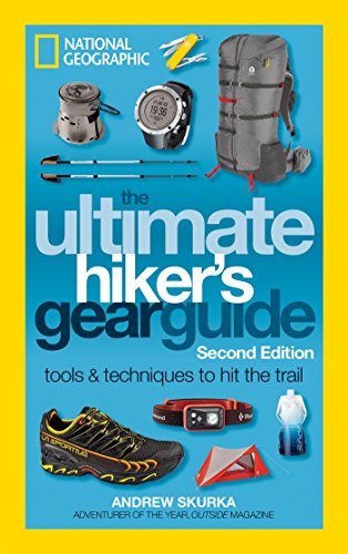
- Always buy your pack last, after you know what it’ll carry. Watch YouTube DIY vids about, and have a friend measure, your torso & waist dimensions.
- Always buy shoes first - professionally fit your shoes + insoles + socks at REI or a running store. Spend a full hour trying on many combos.
- Spend $8 on https://smile.amazon.com/Ultimate-Hikers-Gear-Guide-Second/dp/1426217846/ to learn everything in between.
- Just go. You’ll learn more by doing than on r/
GEAR AID Shoe Repair Glue, Fix Soles, Heels, and Leather and Rubber Boots with Aquaseal SR https://www.amazon.com/dp/B007UTZXT2/ref=cm_sw_r_cp_api_glt_fabc_S2K43VABWCTPJDJ16ZKX
This stuff wears better than the original shoe. On Solomons I find the toe cap often starts to peel and this puts it back for good.
Absolutely! CO is amazing. We went there to Estes Park in November and my five year old did a 1.7 mile hike with us, but he was captivated since it was far different views than Texas. We did go camping last weekend here and during a hike, the kids were asking for more cards from this. It was fantastic, I highly recommend it. Also, find a good hiking stick each hike! Kids love that. They will respect the reason to leave it behind when heading out, and finding a new one next time. gofindit - Outdoor Nature Scavenger Hunt Card Game for Families https://www.amazon.com/dp/B00XKO5RPQ/ref=cm_sw_r_cp_api_glc_fabc_YoKcGbSZ3E9CA
Peak Designs Capture Clip Pro is my method of choice. The camera attaches directly to your backpacking strap via the tri-pod mount on the bottom so it isn't swinging around or anything and the weight is transferred to the pack instead of around your neck. It has a quick release button so you can have your camera up and ready in seconds.
I was worried about dropping it at first so I started to loop the camera strap in the chest strap on my pack so if I were to ever drop the camera it would catch.
I absolutely love the Desolation Wilderness. Accident notwithstanding, it's probably my favorite place in the USA that I've gone. Only problem was camping near Aloha and seeing the lights of Placerville and Lake Tahoe on both sides of the ranges - kind of ruins the illusion, but I'll take what I can get.
I highly recommend taking first aid and search and rescue courses. Like I said, many courses focus on how to rescue someone else, but self-rescue is extremely important because you don't know what might happen. Solo hiking is, of course, more risky than hiking with a partner, but for me that's just not really an option most of the time due to my (very fulfilling) work.
<em>Medicine for Mountaineering</em> is a book I've used quite a bit. It's a little dry (the audience is not laypersons), but extremely informative.
I have WFR and had considered Wilderness EMT certification after grad school, but then COVID hit.
Have you used the hiking project at all? It shows all the different trails for each state with their trail data. Some of em will have pics. I use it whenever I go traveling somewhere new. It's pretty neat. Heres a link to their app if interested https://play.google.com/store/apps/details?id=com.hikingproject.android
If you're on Android I highly suggest GPS Logger.
https://play.google.com/store/apps/details?id=com.mendhak.gpslogger
No map included, but you can configure it to take your position every 3-10 seconds and then load that up on a viewer when you get home and see how much you did.
3 seconds was accurate enough for me at a 4mph pace (which is damn near jogging) and battery is basically un-effected. But longer intervals = longer battery life.
awesome picture, is it this? https://www.alltrails.com/trail/us/arizona/flatiron-via-siphon-draw-trail I've never been there at all but now I want to.
Thanks. According to all trails, it's 10.7 miles and it's on the other side of the mountain (pearl harbor side): https://www.alltrails.com/trail/hawaii/oahu/moanalua-valley-trail-to-the-haiku-stairs-stairway-to-heaven--3
Here’s GPS coordinates and AllTrails link:
34.91574,-111.97820
https://www.alltrails.com/trail/us/arizona/robbers-roost-trail
The GPS coordinates lead you to a parking lot accessible by all vehicles. It’s 3 miles round trip. There’s a closer trailhead, but it requires a high clearance vehicle, and it’s 1.2 miles round trip from there.
Happy to answer
> How challenging was it? I recently started getting my girlfriend into hiking as well. Was wondering if these would be a good place to have her start before she does lafayette for her first time.
These would per perfect. You can make it as easy or challenging as you like. Mt Major, for example, can be done in a nice 3 mile loop: https://www.alltrails.com/trail/us/new-hampshire/mount-major-southern-loop-trail
Really high payoff for the effort. Major is a real stunner.
> Any advice on how we should tackle it if so? Did you find doing it in two runs a lot? How much time did each day take you?
Two hikes would be quite hard for a beginner. 11 or 12 miles a day with 2500-3500 feet each day. Each took me a little over 5 hours including stops, but that's faster than normal. I don't think it's a good idea for someone starting out, although it's fine for someone with experience.
NH Family Hikes has a nice sequence of six hikes for beginners here: http://www.nhfamilyhikes.com/Belknap12list.php
You might want to consider adding Belknap to the Rowe/Gunstock trip to make it five hikes. It doesn't make it much longer and saves a trip. It would be hard to combine Anna with any of the others without making it a grind, which is why they left it hanging at the end.
Seems like this a popular option. I'm seeing I could potentially go from Mt Washington to Mt Clay to the north and then go West to the starting point instead of the out and back? Do you think that makes sense?
​
I would like to think that's not super common to experience if you're researching most hiking trails, especially in the US. Many are maintained (by volunteers, which you should do if you get into hiking!) and shouldn't be so overgrown that you can't find the trail for long stretches.
You should avoid "bushwacking" or "off trail" travel. You might also see "blow downs" referencing a lot of downed trees that haven't been cleared yet. Also look for routes that take you away from large water sources and drainages, since there will be less vegetation. You can look for "thru hikes" that are end-to-end hikes with the modern hiking crowd that typically has a low tolerance for bushwacking.
Depending on where you're going you can find reviews
https://www.alltrails.com/trail/us/tennessee/natchez-trace-garrison-creek-to-jackson-falls
That mentions 'overgrown' trails
This loop is ~10 miles, and covers a section of the Appalachian Trail. Lots of primitive camping available, and I hear the sunrise here is a sight to see.
Check out this trail on AllTrails. https://www.alltrails.com/trail/us/virginia/little-stony-falls-trail
There are parts of the trail that are currently closed... I suggest finding the upper parking lot and the hike in is 5 mins or less.
Thanks! That’s great to know. I was looking at Cathedral Trees, but I was planning on spending one day in Prairie Creek doing the James Irvine to Miners ridge loop, and one day in Jedidiah Smith State Park on this trail: https://www.alltrails.com/trail/us/california/fern-falls-via-boy-scout-tree-trail
Did you go to Jedidiah Smith State Park at all? I’m only going up for two days and then driving back, so I’m trying to make the most of my two days. Im also planning on hiking Humboldt Redwoods State Park on my drive up. I’ll probably only spend a couple of hours there though.
Went on a Tuesday as well a few weeks ago. I would say that it was quite empty. I probably saw around 15 people while I was in the canyon, and I even sat at the end of it for quite some time, around twenty minutes just looking around. I'd definitely make your way to the beach after the canyon too, super beautiful there as well.
If I can make some other recommendations too, I would highly recommend checking out this trail: https://www.alltrails.com/trail/us/california/cathedral-trees-trail--2 Another huge highlight of my trip. The whole of Prairie Creek Redwoods SP was just stunning. Enjoy your trip!! Very jealous. Let me know if I can answer any other questions and I'll try!
It was 7.2 miles climbing over 3,100' and we were able to park literally across the street from the trailhead since the park was pretty much empty.
Lava River Cave near Flagstaff (the cave formerly known as Government Caves)
Humphreys Peak (I'm sure under snow until at least April)
Look at meetup.com and see if there's anything in your area (or close enough to your area that you'd be willing to drive to join up). If there's not anything in your area, start a meetup group.
I don't know what your facebook situation is like, but mine is full of acquaintances -- you could try just putting it out there on fb that you two are looking for people to go hiking with and see if anybody you kind of know is interested.
Not quite mountains but Greenstone Ridge on Isle Royale or parts of Superior Hiking Trail like Bean and Bear Lakes. Also, as already said, Porcupine Mountains.
When I went to Isle Royale, you brought canoes and started at McCargoe Cove and canoed/portage south across the island and then we made day hikes out from our campsites. It was definitely a cool way to see the island. Plus we got to go to the largest island on the largest lake on the largest island on the largest freshwater lake in the world.
Where'd you park? On Falls or at the Park & Ride or by the Dam? It is a nice trail. I see people walking dogs, running, walking with kids or just exploring like you. Here's my last run:
http://connect.garmin.com/modern/activity/591661178#.VEWbuY13tjs.reddit
https://www.alltrails.com/explore/recording/whitefish-dunes-state-park-loop--10?p=-1
Could've walked this easy trail all day and stop in every little cave and outlook but we had a flight in 2 hours ¯_(ツ)_/¯
There’s an app called “all trails” I’m down in CO springs and it works great. It’s an hour drive, and not that long of a hike, but Garden of the gods is a national park class park. Also in the area is beaver creek, and seven bridges trails. Or you could do piles peak. Or go out to one of the other ranges, it’s a ~2hr drive but very worth it.
It’s too bad you missed out on Philmont, I was a ranger there one summer, it’s perfect. If you don’t get another shot at it I would definitely recommend you or your kid does the ranger gig when they’re older.
Edit: words are hard on mobile.
Edit 2: I’ve also hiked up in the “boulder open space” Never been myself but Beverly heights park looks cool. Or Mathew winters park maybe. https://www.alltrails.com/ That’s the website associated with the app I mentioned. It’s where I find every hike I go on. It tells you the difficulty, distance, rating and reviews.
WOOOOO! Hiking is AWESOME =) I saw in another response that you're in Northern CA. I'm envious! There's TONS of beautiful hiking up there. If you're able, you should check out the Boy Scout Tree Trail in Jedediah Smith Redwood State Park near Crescent City.
This is not meant in a snarky way at all, but buy a guidebook. I live on the other side of the world (Aus), so have no idea what's available around your area, but I bet there are plenty.
I like guidebooks, because they often give you better route descriptions, extra information etc, and the feeling of leafing through a real book is second to none. It's also a good way to support people who are often locals. But that's my opinion!
Otherwise, this link seems to offer some possibilities:
https://www.alltrails.com/us/colorado/boulder
I'm sure some others will be along with personal experience soon enough. Hope you enjoy it!
This was taken 100m from the parking lot but I think it's just under 7 miles to go around the lake with a small side trip. See more here.
Close to the city - there's some epic stuff that you can link up in the Marin Headlands. I did some combination of Miwok / Bobcat / Alta trails (trailhead leaves from Rodeo Beach) which is pretty great, and then some of the best views of the city are in the various roads that go parallel Conzulman Rd.
Mt Tam is pretty great, and there's a 9ish mile hike that circumnavigates the peak that I've been meaning to try, though can't speak to it personally yet.
Theres great hiking to be had in the muir woods area - my favorite way of doing that is picking two of the routes that go from the Panoramic Highway down to Stinson and back - Dipsea trail, Steep Ravine trail, Matt Davies trail -- they all link up. Would probably recommend going up Steep Ravine, and while dipsea is more historic I think I like MD more. For some added mileage / vert you can start in Mill Valley (park at Old Mill Park) and do the stairs part of dipsea.
Another mention in the Mt Tam / Muir Woods area is Bootjack trail, which I ended up on accidentally once and is one of the coolest redwoods river bed trails that I've seen in the area.
A little farther north - Pt. Reyes is obviously great. Hiking to Alomere Falls on Coastal from the southernmost part of the park is a good 7ish miler with lots of add-on opportunities. The waterfall opens out onto the beach, which is cool, though it also tends to get crowded so I'd leave early. The rest of the coastal trail through the park is also pretty epic, though I havent done all that much else.
Side note--if you do make it up to Pt Reyes, i'd highly recommend making a stop at Bovine Bakery in Pt Reyes Station, though theres other stuff in town too.
Also just remembered that this has some decent route plans for some of these - 4, 7, 9 and 10 include sections of what I talked about above.
Hopefully that helps!
New Paltz ( Minewaska State Park or The Gunks) you can take a bus to new paltz but then you need to get a ride to the park. taxi or hichhiking
I used this guide and added half dome to my Day 3. Favorite camp was Merced Lake, secluded with a nice view of the falls and river to wake up to.
Total trip was 40+ miles and completely amazing. First 3 days secluded (even Half Dome was empty around 8am) we saw on average 8 people a day. Day 4 in the village was a shit show but I loved it.
Let me know if you have any questions!
Well Dayton is western Ohio.
Caesar creek is pretty close to Dayton.
Here are some more: http://www.everytrail.com/best/hiking-dayton-ohio
If you really mean eastern Ohio, then check out Hocking Hills, the waterfalls are great this time of year.
I almost did Mt Leconte Summit last summer - http://www.everytrail.com/guide/mt-leconte-summit-via-alum-cave-trail. Alas, weather didn't cooperate and I had to turn back about 3/4 way in dense fog. The good thing about this trail though is that even if you don't attain the summit, the trail has interesting features along the route. Oh, and you can spend the night at the top if you make reservations ahead of time.
My fiance and I were Looking at going to the wheels through time motorcycle museum there and camping and hiking along the way. While planning I ran across this site which may be of help to you.
I spent weeks researching and planning the route. Double checking every resource etc. I plotted it out on a GPS tracker guiding me to the exact path. Looking at this every 10 to 15min because so easy to go on the wrong path. I attached a link of the path I did.
I didn't find any location as small as you described. But still it is daunting if you fall at certain parts you are gone.
Really recommend for experienced hikers/ climbers only. Also good weather is essential.
Glad you made it.
Also bones route
Cheers, have a look at this Link, we did the same Tour, Just in opposite direction. Unfortunately Not in english https://www.outdooractive.com/mobile/de/route/wanderung/allgaeuer-alpen/uebergang-prinz-luitpold-haus-zur-kemptner-huette/26789150/
Along the Rhein river is a nice trail. You can also select different stages. (And have a good wine in between as it’s partly vineyards).
Then if you want to take a longer train ride, the Black Forest is amazing.
https://www.blackforest-tourism.com/discovery/hiking/long-distance-trails
My water froze to slush climbing Whitney in October 2018. Lesson learned: Always take some hot water in a vacuum flask with you if it gets somewhere near chilly and you do a substantial climb...
http://www.ipernity.com/doc/charly13/47564460/in/album/1202584
Christopher Titus just talked about this on his latest podcast! (sort of) https://podcasts.google.com/?feed=aHR0cDovL3RpdHVzcG9kY2FzdC5saWJzeW4uY29tL3Jzcw&episode=ODAwYzU2ZGUwNmFlMzZjNmZiMThjMjA1N2E4ZjNjNzI&at=1562096662640
Probably doesn't help in your current situation, but I use Strava to track while I'm hiking, and it gives me distance/elevation. Then for display purposes, I download the GPX and load in Caltopo to get the tracks on a topo map like this: https://sway.com/s/Vrd86P9DJd1HeNuk/images/_gh82s1tiiC1X_
Your on a good start, your best bet imho is to concentrate on breathability of your clothes in hot weather (depending on your area) and also keeping warm when at high altitudes (again depending on your area) If there is 2 things I would try to always have in a day pack it's an emergency bivy bag like this;
https://www.rei.com/product/862117/sol-emergency-bivy-xl?
And a way to filter water such as;
https://www.amazon.com/dp/B00FA2RLX2/ref=cm_sw_r_cp_apa_glt_fabc_E33D5Z6HX3B74FEEDHR9
I have had more than once where I didn't bring enough water, and this saved my butt.
Past that, clothing of the correct type are very important, but I am still novice at this. I use smartwool for early or late in year, and mostly polyester in summer.
I would welcome others with more experience for clothing advise.
found it (or something similar) https://www.amazon.com/KingCamp-Stainless-Collapsible-Accessories-Backyards/dp/B08B3M6KJW kinda cool, never heard of a portable fire pit
I'm not familiar with the Lake District, but the wiki looks cool. Hilly, rocky terrain with lakes. Wiki says the highs only get around 59f?
This would be my weapon of choice 100% https://www.amazon.com/Bates-Mens-Combat-Hiker/dp/B00A53FCD2?th=1
Amazon.de lists a 2020 folded map by Hochgebirgsforschung, but it is currently out of stock. You should be able to find another source.
Good luck! Hiking that loop was on my wish list when I was much younger.
Here's a GoPro Hero 8 Black that meets your budget. I think GP's are great - they have larger sensors than a typical phone to enable you to get high quality videos. Save your phone for other uses like texting and taking additional photos and video footage to complement the GP footage. https://www.amazon.com/dp/B091G1TJ32/ref=cm_sw_r_cp_apa_glt_fabc_ZXY6QCG60R6RVRFE3PCC?_encoding=UTF8&psc=1
You might want to add the accessories kit (a must): https://www.amazon.com/dp/B01171X0UW/ref=cm_sw_r_cp_apa_glt_fabc_P2GHFQMD62YRWW2HJFVB?_encoding=UTF8&psc=1
I got sone Scarpa trail runners that I use for light hikes. Pretty comfy with good Vibram soles.
Scarpa Mens Neutron 2 GTX Trail Running Shoe https://www.amazon.com/dp/B074QTGL5F/ref=cm_sw_r_cp_api_glt_fabc_WT9XEPE41GW1Z9EMSEWE
I’ve never had any problems with mine, but I’m sure it’s not the right bag for everyone. The water bottle thing is an issue, but I prefer to use those side pockets for shoving things like gloves, a bandanna, etc, so they sort of become my shove-it pockets.
For internal storage, I like using bags like thisthat clip onto the inside of my bag and can be moved from bag to bag. Great for things you want to easily grab like first aid, moleskin, water purifying tablets, electrolyte tablets, etc. I don’t know anything about the bags I linked, but I have similar ones from Mountain Hardwear that are going on 20 years old now that have held up amazingly well.
The Skarab is a solid bag. If you’re a bigger person the 30L might not feel too big.
Do you have a local outfitter that’s open where you can go and try on some of the bags? That might seal the deal for you. I know with the pandemic trying things on is tough, but you’re in Florida, and it seems like most of Florida is operating business as usual, no?
I have those pants (also no zip) and I like them, but they are a bit more rugged and less lightweight loungy.
What about scrubs? Super lightweight and comfy. Easy to move. They even have quick dry stretch ones. Amazon Essentials Men's Quick-Dry Stretch Scrub Pant, Navy, Medium https://www.amazon.ca/dp/B077TQCJSC/ref=cm_sw_r_cp_api_i_P7KN66YDERM26ZVW2473?_encoding=UTF8&psc=1
Obviously looking for something small, lightweight. Weight to charging capacity ratio is huge.
This is the power bank I use on trail.
The Teton 1100 is only a 19L pack.
They make them in sizes up to the Grand 5500/90L.
To keep it simple, just buy a bigger pack and stuff the camera bag you already have into that.
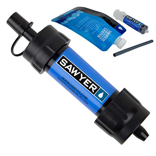
Sawyer Squeeze or this: lcfun Waterproof Lighter Outdoor Windproof Lighter Dual Arc Electric Lighters Rechargeable-Flameless-Plasma Lighter for Camping,Hiking,Outdoor Adventure (Red) https://www.amazon.com/dp/B07W7WQ3MG/ref=cm_sw_r_cp_api_glc_fabc_lou3FbJ7Q7HW5?_encoding=UTF8&psc=1
I have an Osprey bag and looooveee it. It's awesome because it's two in one, so I have the small day pack for short trips, but the huge backpack for long hikes (I actually travel full time and live out of it too). It also opens up like a suitcase which is super convenient. The company gives a lifetime guarantee for them so if something snaps or rips you can send it in to be fixed or replaced. I've been using mine for about a year and recommend it. It's definitely pricey (here's the Amazon link: https://www.amazon.com/dp/B014EBLI7Y?colid=1JUHPBXFPJXNE&coliid=I1GJ3DP66U6CUQ&ref_=hit_wr_dt_vr_md_pt) but I think it's a good investment.
It's not what you asked for but I went through the waterproof boot phase. Did not work. Water is often higher than the boots and then the boots never dry. So I bought waterproof socks that come to mid-calf. Use them with trail runners. Weight 122 gms for 2. I love them. They work. Got 100's of miles on them and still work. Got them on Amazon: waterproof socks
I got this nifty map from Amazon for when I’m ready.
- Always buy your pack last, after you know what it’ll carry. Watch YouTube DIY vids about, and have a friend measure, your torso & waist dimensions.
- Always buy shoes first - professionally fit your shoes + insoles + socks at REI or a running store. Spend a full hour trying on many combos.
- Spend $8 on https://smile.amazon.com/Ultimate-Hikers-Gear-Guide-Second/dp/1426217846/ to learn everything in between.
These are the ones I've been wearing, both when I was on duty (police officer) and when I'm out hiking, probably for a good 10 years now. Nice wrap-around and full view.
Check out Kamik boots like their Nationplus. I hike in these in sub zero temps and my feet are never cold. They have a removable liner which helps to dry them out when camping. Microspikes and snowshoes work well with them too.
I use map my hike. Does exactly what you said. Measures distances, speed, times, splits, elevation etc. and overlays the route onto google maps.
I bought Backcountry Navigator for Android a while back and like it.
Never tried any other ones so I can't compare but am generally happy with that.
** For Japan (only)**
山と高原地図 In app purchases. Sample map of Takao available for download. They print paper maps which I also bring with me. UI is all Japanese.
地図ロイド (chizroid) uses free GIS data from a local government server so needs a network. Haven't figured out how to pre-download all the map tiles I need. Custom maps usable! UI is "English".
SAS Survival Guide is one of the better apps you can have.
There's also a free Army field guide, but it's not very phone friendly.
#1, I'll look up the wag bags. Everything must be packed out, no burying for us.
#2, I've wondered about that. I've got a 10 year old son that I worry about- I'm sure my wife and I would both be fine for the other, but him...
#3, yeah, bad knees/hips kind of thing. I'm wondering about a small squatting toilet, something like this - https://www.amazon.com/TRIPTIPS-Portable-Folding-Toilet-Camping/dp/B08P535474
Re #1, get some Wag Bags these you carry out, but apparently have a chemical powder in them to prevent the stink. OR: Not sure if burying the waste is allowed there, but a good poop kit is easy to carry. Just need a trowel (Deuce of Spades for instance) and biodegradable TP and hand sanitizer.
#2 have your significant other stand guard. Could also bring a small silnylon tarp and have them hold it up, or you can tie it off to trees (or trekking poles). Check out these dual purpose poncho tarps: https://www.amazon.com/Ultimate-Arms-Gear-Waterproof-Military/dp/B01G2EXZSQ/ref=sr_1_37?keywords=silnylon%2Bponcho%2Btarp&qid=1671662005&sprefix=silnylon%2Btarp%2Bponcho%2Caps%2C152&sr=8-37&th=1&psc=1 I have one like it from aliexpress. I use it for wind deflection when I'm taking breaks on day hikes or backpacking.
#3 not sure I understand. If you have bad knees/hips like me then squatting is painful. I try to use the lean-against-a-tree/rock method wherever possible. A fallen tree can also be a nice place to sit with your butt hanging over. Though trees are likely not prevalent there. So not sure how to help with this one.
- Always buy your pack last, after you know what it’ll carry. Watch YouTube DIY vids about, and have a friend measure, your torso & waist dimensions.
- Always buy shoes first - professionally fit your shoes + insoles + socks at REI or a running store. Spend a full hour trying on many combos.
- Spend $8 on https://smile.amazon.com/Ultimate-Hikers-Gear-Guide-Second/dp/1426217846/ to learn everything in between.
- Just go. You’ll learn more by doing than on r/
A read a book called Weird Hikes a few months ago that was full of this kind of thing. You might like it.