
What are
/r/WildernessBackpacking's
favorite Products & Services?
From 3.5 billion Reddit comments
The most popular Products mentioned in /r/WildernessBackpacking:


The most popular Services mentioned in /r/WildernessBackpacking:
AllTrails
ipernity
Meetup
The Weather Channel
Walmart
Weather Underground
SemanticScholar
SlideShare
OpenStreetMap
Costco
Camelcamelcamel
NPR News
Outdooractive
Locus Map
QLandkarte GT
The most popular Android Apps mentioned in /r/WildernessBackpacking:

Locus Map Pro - Outdoor GPS navigation and maps

Locus Map Free - Outdoor GPS navigation and maps
BackCountry Navigator TOPO GPS
BackCountry Nav Topo Maps GPS
Knots Guide
The most popular reviews in /r/WildernessBackpacking:
Nice pic! tell her to remember exactly where her blisters were and tape some of this magic on those spots before your next big hike!
I agree with the above posts (minus the tourniquet). And, though it's the weirdest fucking place to find great snake bite treatment information, I swear, just read the first review of this product on Amazon and prepare to have your mind blown while reading the most helpful review in the history of mankind. https://www.amazon.com/Sawyer-Products-B4-Extractor-Pump/dp/B000AU9PEC/ref=sr_1_1?ie=UTF8&qid=1495611042&sr=8-1&keywords=snake+bit+kit
To add to this these are the ones I use when walking through cottonmouth territory
I got a random rotation timer tripod for my iPhone. This one is not the one I got but it looks the same. No batteries required.
These are a great alternative to the wetwipes. They're dry so they're lighter and also scent free which is a plus for hunting.
Wysi Multi-Purpose Expandable Wipes, Just Add Water - 100 Compressed Tablets https://www.amazon.com/dp/B001NWVBPC/ref=cm_sw_r_cp_apa_i_naH3DbDJHKRJX
There's a fairly famous book about the many cases where people have died on Washington. You don't have to deal with altitude sickness like the rockies but when the weather turns it can get ugly quick. A month or two ago the weather station on the summit recorded continuous winds over 110mph for 3 straight days.
I carry a PLB. You just register it with NOAA with your name, address, and emergency contacts and that's it. Several years later you need to send it in for a new battery and checkout.
I've always believed it's an insurance policy on group hikes or backcountry ski or mountain bike trips if somebody gets hurt. I could also help an injured total stranger I find on the trail. 100% of everybody carries a cell phone nowadays, but casual hikers apparently don't know they frequently don't work in the mountains. If somebody does get hurt, have everybody try their cells first before activating the PLB. Different carriers, who knows? They might work.
Downside is there's no two way communication. You can just call for help, but you can't tell them if you're lost, broken leg, having a heart attack, etc. I read somewhere PLBs have a stronger signal than InReaches, SPOTs, etc. so they're less likely to be blocked by trees overhead.
We (group of 2) backpacked the Wonderland Trail in August 2018. The total trail length was ~93 miles, which we did in 6 days. We planned our route using this guide book. We started at Longmire and went in the clockwise direction.
http://camelcamelcamel.com/Highlander-Outdoor-Discovery-45-Liter-Rucksack/product/B00BNTOVC0
has it even been sold for $100 or is it just good marketing? Look at watches on amazon some time. Every single one is a $2,000 dollar watch available year round for $150. Makes you wonder if they aren't just $150 watches.
In the interest of disclosure, I am an REI retail employee.
Let's start with sleeping bags. The Marmot Tressels is probably your best bet under $100, but it's definitely on the heavy side for a backpacking bag. If you can bump up to the $150 range you can get into the Kelty Cosmic Down or Marmot Tressels Elite, which will be substantially lighter and more compact.
For pads, you've got pretty good options. The Big Agnes Insulated Air Core Ultra, the REI Flash or Stratus, various Therm-a-rests or Klymits...it's a pretty wide open field.
Good packs are hard to find for under $100 new, but are much more trustworthy used than bedding. Check out Ebay or Craigslist.
Failing that, the Kelty Redwing is a pretty respecable pack for the lower end of the price spectrum.
In terms of tents, there are plenty of good 3-person options under $300, the lightest of which I can think of off the bat is the Kelty TraiLogic.
For stoves...this is among the best camp stoves I've ever used. Does not need to be complicated.
For cooking, there are a fair few hard-anodized aluminum camp cook kits on Amazon for fairly cheap that will do just fine. For 3 people, look for the largest pot to be in the 1.5-2 liter range.
Let me know if you have any other questions.
I use backcountry navigator (https://play.google.com/store/apps/details?id=com.crittermap.backcountrynavigator.license). It has pretty much all the features you could ask for. The real limiting aspect of phones is the rather junk nature of the GPS when not in cell range. It can take a long time for gps lock (like several minutes), during which a lot of power is consumed.
For occasional use I think it's fine, but if you're going to be checking on your position constantly because of backcountry off-trail travel, I'd stick with something like an etrex 10 and printed charts from caltopo.
REI has the etrex for sale really cheap right now; I think it would come out to about $50. The battery life, durability, and lock on speed are much better.
I actually like snake gaiters... they are a lot more breathable than boots and you can put them on a take them off as needed, but carrying telescoping trekking poles is a must too because you can basically pretend to be a blind person with their cane and snakes will scatter at the vibrations
Wife just started using these. She's had 1 leak while sleeping, but otherwise they've been great for her. Never used on the trail, though. She has pain with tampons, but only mild discomfort with the cups.
We've looked into the reusable bamboo pads, but they're a bit expensive. Well, looking on amazon they seem cheaper now. https://www.amazon.com/Charcoal-Menstrual-Reusable-Sanitary-Hibaby/dp/B01MT09RUQ/ref=sr_1_1_a_it?ie=UTF8&qid=1503611230&sr=8-1&keywords=bamboo+menstrual+pads
Used to be 20 bucks a piece.
Yeah, they are obliged to follow the standard set by the USDA for what constitutes a serving. After a long hike, you are obviously burning way more calories than the average American and will need to eat more as a result.
I'm not a very big guy but a 2.5 serving for me alone is rarely enough. There's already some good advice here on how to supplement your meals, but I'l add that the Backpacker's Pantry brand fills me up more. Some people seem to not like them but a spice missile loaded with some salt, pepper, garlic powder, etc makes any of these meals taste fine.
Thatsalotta food! I’m all for having plenty of food, and am somewhat prone to overpacking. That being said, it can be really helpful to think about when you will eat everything you bring, and realistically how much. For a 1-2 nighter, food for two of us usually fits easier in a gallon freezer bag and we each carry a few individual snacks.
That trail looks beautiful! Keep an eye on conditions though, it looks like the Coast Guard had to rescue someone recently? Assuming this is the same trail, there is a recent review that mentions it: https://www.alltrails.com/trail/hawaii/kauai/na-pali-coast-kalalau-trail?u=i
It seems to be $53 on Amazon and $60 for your link? Am I looking at a different one?
These ranchers don't do any of that. They pay the BLM something like 10% of the amount it would cost to "rent" private land to graze their cattle, and don't maintain anything. It still falls on the BLM to rehab wrecked watersheds, maintain roads and fences, etc. and the only reason the ranchers rotate grazing land is because the BLM disallows permits in areas for a while to allow the grass to come back.
There was even a case last year where a county sheriff threatened to arrest any rangers if they tried to close any of the federal land to grazing (they had plans to not renew grazing permits in a certain area because it had been overgrazed).
Sure. We neglected to get into the permit lottery in time, so we decided to just show up and try our luck at the backcountry office. We got super lucky and got a permit.
The route was from Hermit’s Rest trailhead to Boucher trail, first night at Yuma Point (shown). Day 2- Yuma point down to the Colorado River. We camped on the beach where Boucher creek enters. Incredible spot. Day 3- We hiked onto the Tonto Trail, back to Hermit’s Rest Trail and camped at Hermit Creek Campground. Day 4- Up the Hermit Creek Trail, and the Cathedral Stairs back to the rim.
Awesome trip. Gorgeous route. We encountered just two other groups until we got to Hermit Creek Campground. Perfect weather.
It was essentially this route , with the addition of the leg to the river, for a total of 22.4 miles.
If you are comfortable with it and prepared, sure. Doing a hike in campsite like that is definitely a good way to start. I might actually suggest a more popular destination to start, so there are people around even if they aren't ones you came with.
Two major things, especially if going solo:
- Make sure someone knows where you are going and when to expect you back (and worry if you aren't back)
- Absolutely make sure you have a good gps/map and compass and know how to use it. If your phone is your GPS, make sure you have an app that will function with out connection (I use Gaia Topo and pay for offline. Alltrails is another option for popular trails), and make sure you keep it on airplane mode so it doesn't run down the battery searching for service (GPS works in airplane mode). The biggest 'danger' in the plans you describe is you getting turned around on one of the 'day hikes' with most of your stuff back at camp (and frankly two people without a map/gps isn't much better than one - this isn't really a 'solo' hiker issue)
For looking for people to go with in the future: meetup.com often has outdoor groups that can be a good place to meet people (and sometimes facebook). If you are a university student, colleges often have an outdoor club and run trips.
I'm not sure about the Park itself, but Crags Trail (Trailhead at 38.87182N, 105.12344W, 10119ftASL) and Horsethief Falls Trail are good, shorter hikes - they are both on the western side of Pike's Peak. I used to live right down the road from both.
https://www.alltrails.com/us/colorado/divide
All that being said, calling anything on and around that mountain 'moderate' is pretty misleading. In the surrounding area, Woodland Park sits at 8500 feet above sea level, Divide is a bit higher, and the road from Divide to Cripple Creek passes above 10,000 feet above sea level, before decending in a mile-plus long series of switchbacks. The terrain is an awesome challenge, and the pink granite is very, very brittle and highly prone to errosion. Oh, and slicker than owl shit.
If you just happen to be a service-member, there is an USAF recreational area just to the southeast of Woodland Park - Farrish Recreational Area.
This is a pretty good resources --> http://salida.com/salida-best-of/best-of-arkansas-river.html
Salida is a good base as it is pretty much in the middle of the valley and provides good access to the Sand Dunes as well as up to Leadville. There's a lot of good stuff in Salida too, check out Elevation Brewery if you're into the Colorado craft-beer scene.
As far as trails definitely check out https://www.alltrails.com/ if you don't already use it. It will give you a good idea of the trails in the area.
With a bit of a learning curve on grids, coordinate systems, projections and the like... A proper GIS system allows you to see a great deal of different information in the same interface.
QGIS is open source and quickly becoming the standard, you can add layers from government servers depending on availability. Things like geological and metallurgical maps, old parish maps, geo-referenced photos you've taken of maps in books or whatever. OSGeo4W installer will include this and a bunch of tools like GDAL.
You can then export layers you create as KML, GPX or whatever is needed.
While it's more typical to find information readily available on the internet these days, I can recommend Joe Miller's Backpacking North Carolina as worth the expense and will give you some good ideas.
If you're in WNC proper, one of the trips in this book is the Cataloochee Loop which is 9.5 moderate miles around the Caldwell Fork with a side trip up to Hemphill Bald.
Another Smokies loop in this guide is the Deep Creek Loop out of Bryson City which goes up the Deep Creek Trail (very mild), across Martins Gap (stout, but short, take your time), and back down the Indian Creek Trail. It's about 13.5 miles. I've done it in two nights three days as a total lollygag with more relaxing than hiking.
If you're closer to the Piedmont, then Uwharrie or South Mountains SP would be good options for getting your feet wet.
To clarify:
The one who is 'most homeless' wins?
Maybe the rules could use refining but I'm here to help, not to judge.
Here ya go. Get a gallon ziploc bag and all of these instant refried beans you can fit into your weight limit. Add water, and eat. You should be able to get like 48 packages of these in your wright allowance. If you eat 2 servings per meal, a package should last you a day. So 48 days worth of meals, give or take a bit. Maybe fill out the last bit of weight allowance with multivitamins.
Might not want to do Taco Tuesday after this for a while though.
I also got giardia when using tablets to purify water (about 7 years ago). Not fun. Since then, I have been using a product called Polar Pure, and it works like a charm. I've been out for weeks at a time and used only this (it's like a refillable iodine solution, lasts for 10-15 years easily) and had zero issues. Super reliable, love the stuff.
I can find Bear Creek Darn Good Chili at my local Kroger-owned grocery store. It takes some simmering so it takes a while, and I add some sun dried tomatoes in place of a can of tomato paste.
If you have two pots you can do instant mashed potatoes and Stove Top stuffing as a meal.
Often the issue is getting enough fat content into whatever you're eating. So carrying a small amount of olive oil or ghee (clarified butter that doesn't have to be refrigerated, available at Indian grocery stores) to mix in with your entree can help a lot. And for breakfast, you can do either oatmeal or GrapeNuts (for a nice crunch, remember to sweeten it a little) but you should definitely mix it with powdered whole milk, which is a little hard to find. I usually get it at a Mexican grocery store, but last time, I tried Peak that I ordered from Amazon and really liked it.
In any case, I like to measure the stuff out into ziplock bags (and maybe Sharpie the instructions onto the bag) because the off-the-shelf packaging seems ridiculously bulky (and likely isn't in the proportions you need).
I just want to add how important these small tips are. Digestion warms you very quickly. I've motocamped in as low as 10'. I don't have any real high performance clothing, just jeans, carhardt coveralls and a hoodie. Cheap green tea from any grocery store is great because it's non-diuretic, decaffeinated and with Ozark trail Yeti knockoffs, it's easy to keep a mug hot while you sleep. Chex mix type stuff is great to munch right before sleep and to keep with you through the night. Dunno if it's placebo effect or not, but liberally sprinkling cayenne on it gets me warmer quicker.
I also found, and by no means am I suggesting pharmaceutical drugs (other than maybe a joint by the fire) a couple of melatonin tablets with me helps ease me into sleepy land.
If you're in a hammock I suggest keeping your tumbler on the ground and your snacks and peebottle inside with you. However since I've seen this, Rtic Stainless Steel Bottle (36oz) https://www.amazon.com/dp/B01GS9MUHM/ref=cm_sw_r_tw_api_9YMezb20NK52M #Amazon I'm debating just throwing it in the sling with me.
Injinji 2.0 Men's Run Lightweight No Show Wool Toesocks, Charcoal, Medium https://www.amazon.com/dp/B00AK8CMS0/ref=cm_sw_r_cp_api_jFLizbD983C2W
I have spent way too much time on Amazon in the last six months.
Get a closed cell foam (ccf) sleeping pad like the Zrest. You're young, your body can handle the hard ground, but we all need thermal insulation, even in the summer. That is what sleeping pads are really made for. As you get older, you'll likely want a more comfortable air mattress, but those are more expensive, heavier and more prone to issues.
Don't do an esbit stove. They smell for one thing. Just buy a cheap, $20, 25g BSR stove from Amazon: https://www.amazon.com/BRS-Ultralight-Camping-Portable-Titanium/dp/B01AKF4USW/ref=sr_1_2?s=sporting-goods&ie=UTF8&qid=1496159425&sr=1-2&keywords=bsr+stove and buy a fuel can from REI.
I haven't gone backpacking with my toddler yet but we have done some car camping just to get him excited about it. I was really paranoid about him getting smothered in a true sleeping bag so I got him a sleep sack with arms and legs from Amazon. Anything with 3.5 Tog would be for below 59 degrees. Like this one: Slumbersafe Winter Bamboo Sleeping Bag With Feet 3.5 Tog I Love Teddy 18-24 months https://www.amazon.com/dp/B01GNBIP38/ref=cm_sw_r_cp_api_di7XzbGBPA6TS It usually dips pretty low where we are so I put him in fleece pajamas, the sleep sack, and potentially a little beanie too. He didn't do so great on his first trip and I was super disappointed and thought my dreams of family camping would have to wait a while. But we tried again and he did awesome! Good luck!
I used Locus Maps Free for hikes in the Joyce Kilmer national forest last year, and liked it so much I bought the pro version. It allows you to import your own offline trail maps which you can find for free on the internet.
The whole route is shaped like a lollipop - the east fork quinault river trail up to enchanted valley is the out and back section. The loop is beyond enchanted valley - up Anderson pass and around O Neill pass.
https://www.alltrails.com/trail/us/washington/enchanted-valley-lacrosse-basin-oneill-pass-loop-trail
Thanks for the reply! The Baron Lakes were absolutely amazing. Someone I met on the trail said they heard it was overrated so getting to it I wasn't sure what to expect - it definitely wasn't overrated and was a highlight of the trip. I'm glad I setup camp there the last night.
I ended up doing the large mileage sections of the hike/circuit first as I figured those would be the days when I'd be most apt and energetic to get a large chunk of trail done since I would be fresh and not trail worn.
Here's a map of the route I made in AllTrails - hopefully this link works for anyone who is curious:
Thanks! There is only one legal trail to the campsite - it's just call the Kalalau Trail. It's 11 miles one way and includes the option for two side trails to huge waterfalls. Booking a permit is the tricky part - you need to get onto the permit site right at midnight 30 days before your trip to get a permit since they sell out immediately.
There's a loop up at the Grandjean campground. It's about 18 miles or you can extend it and go to the Stanley Lake and that'll be an extra 14 miles for a total of 32 miles.
Check out this trail on AllTrails. https://www.alltrails.com/trail/us/idaho/grandjean-sawtooth-lake-loop
neither trail head will have cell service so on the outbound we come out maroon snow mass trail and road walk a couple of miles till we get service and then call uber.. this is what we put together as our version of 4 pass https://www.alltrails.com/explore/trail/us/colorado/capital-creek-loop-to-haystack-mountain?mobileMap=false&ref=sidebar-static-map&ref=sidebar-view-full-map
Consider stalking ebay as well. I've found plenty of NOS shoes on there with some time... you may not find them today... but if you set up an IFTTT for your search, it'll just email you when someone lists it.
I took a risk and ordered this tent the other day. http://www.gearbest.com/camping/pp_184913.html
Since I ordered it the price has gone up $10.00 but I took a gamble on it. If it doesn't perform then I will count it as a loss.
As for the footprint issue. I use tyvek home wrap cut to whatever size I need. It is lightweight, extremely durable, and pretty cheap.
My current fav. Can't beat the price https://www.walmart.com/ip/Outdoor-Products-Arrowhead-Backpack/51036936?wmlspartner=wlpa&selectedSellerId=0&adid=22222222227039387108&wl0=&wl1=g&wl2=c&wl3=80416918969&wl4=pla-177639076369&wl5=9032722&wl6=&wl...
Got me thru Nor Cal and Oregon on the PCT this past summer and still going strong. ; )
Here's the All Trails link.
Love this loop. Very few visitors in September, no crazy long/steep passes, plenty of really pretty lakes and some spectacular views. You can expect some snow in September, especially this year, but I've gone without spikes and have had no problems.
https://www.alltrails.com/trail/us/california/matterhorn-canyon-and-the-sawtooth-range-trail
this is the full loop. We did half of it going counter clockwise and exiting down the trail in the middle which goes over sawtooth pass. You have to drive two hours down a spooky one lane road to get to the mineral king trailhead. I can’t speak about the northern half cause we didn’t do that. Franklin lake on day one was a nice easy way to get acclimated to altitude while only hiking 5 miles. Next day hiked over franklin pass down and around to little Claire lake. The following day about 9 miles to the lost canyon, which is stunning. Last day was up and over sawtooth which was an adventure cause they way down is all scree.
You could easily extend this trip and include some fun off trail stuff as well. Franklin lake was my favorite campsite. It had a legit little sandy beach and we camped in a cute grove right next to the beach. We got in early and laid out all afternoon. Apparently it can get crowded on weekends but we were completely alone on a Wednesday.
Found this the other day while searching for the same answer... https://www.omnicalculator.com/sports/hiking
I haven't used it to plan any trips and I'd like to hear what others think of the numbers it puts out.
I think Trapper's Falls trail is the best trail in the porkies. Government peak trail is not worth your time. Basically the east side of the park isnt worth its IMO. The escarpment trail is nice.
I would look at doing something like summit to trappers, stay next to the lake (wonderful campsite right there, good skipping stone beach too.) then up big carp maybe?
Honestly I have never been that big of a fan of the porkies. Since you have been there twice I would suggest something new. maybe pictured rocks (great one nighters there) or even do a section of the NCT?
Looks like you are going to hit some weather. https://www.wunderground.com/q/zmw:49953.1.99999
Hey if you liked it you are in for a great first trip. It is popular place and should be in for a great time if you liked the prokies before.
Hi there! We are more Northwest (Harrison area). We are doing Rockfish Gap to Chester Gap in the Shenandoah Valley in Virginia: https://www.alltrails.com/es/explore/trail/us/virginia/appalachian-trail-rockfish-gap-to-chester-gap
We are so excited to do this. We've been slowly ramping up our hikes and backpacking trips in preperation. We're doing a 9.5 trail on Sunday, then we have a 24.5 scheduled in Feb.
Here is for the actual peak -- if you start from the Sugarloaf campground parking lot as your staging area, then the Brown's Loop and the Med Bow loop will all start and end at the same place. (Click on the 'view full map' option on either alltrails page.) You could do Brown's as a one night / two day backpacking trip, camp at the campground the second night ($10 / night) and do Med Bow as a day hike on the third day. Be warned, even as soon as next month, nighttime temperatures will have the potential to get chilly! There's a standing fire ban also, so don't plan on having a fire on your backpacking night. Also, mosquitoes. Let me know if you have any other questions - I live here.
https://www.alltrails.com/trail/us/wyoming/browns-peak-loop-in-snowy-range
That’s essentially the loop I did, spent the first night at deep lake, then to heart lake for 2 nights (summit day), and then at the north gap lake and back.
This map is a Frank Church loop. Its about 105 miles through some of the most remote wilderness in the country. I only say this because I don't know your skill level, just a general disclaimer, but this is not an area that you are able to bail out of. Your only options for getting out are hitching a ride on a bush plane or a river raft. If you have a spot or gps device, there are options for rescue that way, but you will be intensely isolated in these areas. Along Big Creek and the Middle Fork there are ranches and homesteads grandfathered into the wilderness so there are opportunities to drop in, maybe get a meal or a room, etc. If you look at the maps, many of the "ranches" are hunting and rafting outfitters that have some pretty impressive amenities. There are options for flying in resupplies. There is a usps air mail plane that flies every wednesday so there are no extra fees besides general postage (which is insane). I can give you more info on that if you want.
Check out this map(https://www.alltrails.com/explore/map/sawtooths-loop--5). Thats about 75ish miles looping the Sawtooths from Stanley Lake and hitting the ICT on the West side. You can extend the loop by hiking into Red Fish Lodge (beer and burgers), adding the Alice-Toxaway Loop from Imogene Lake (incredibly scenic), hiking south on the ICT along the Middle Fork of the Boise River to Atlanta (hot springs, cliff jumping, burgers, beer), and Sawtooth Lodge at Grand Jean (Hot spring pool, burgers and beer, the lodge is the cabin of Emil Grandjean, first forester of Idaho and pal of John Muir).
I would start here by determining where permits are still available. With short notice, I have had success hiking out of Bridalveil Creek, on the southern side of the park. Buena Vista Lake is a beautiful destination in that area. Here is a cool loop I found in that area matching your distance preference. There are definitely more popular hikes along the JMT and near the valley, but those permits are harder to snag with short notice. Besides, all parts of the park are beautiful! Good Luck!
https://www.alltrails.com/trail/us/colorado/rattlesnake-arches
It's one hell of a doozy getting there. If you are flying I would rent a 4wd. I drove my fwd tiny convertible going slow at 10mph and still had to park a few miles up the road from the trailhead
Latir Loop - Alpine lake camping and a good deal of time spent above 12,000'. Can hit as much as 5 12ers depending on how long you want to spend out there, but it's really easy to hit Latir and Virsylvia Peaks at least.
Santa Fe Baldy Loop - See the famous Lake Katherine and hit 3 12ers.
Wheeler Peak has been mentioned, but I think this is a better day hike than overnighter. Can still be done, though.
If there is snow you might want to check out your options in Bandelier National Monument, especially if you are interested in ruins.
I recently completed this route over eight days...https://www.alltrails.com/explore/map/2017-yosemite. It was a lot of hiking but I'll never forget the experience.
This is our (from my girlfriend and me) post about or three week hiking trip to Iceland in 2018. No hotels, no campsites, nearly no contact to other people. I hope this supports some of you when planing a similar trip.
Please give us any kind of feedback you have. Because we're both from Germany, feel free to correct any kind of language mistakes as well. Thanks!
​
For those of you who are technically interested:
The site is build with hugo, so feel free to take a look at my GitHub repository.
This bike bell will make continuous sound or you can “turn it off”.
TIMBER! Mountain Bike Bell - Quick Release
Model https://smile.amazon.com/dp/B0184TO7NY/ref=cm_sw_r_cp_api_glt_fabc_E3GPAX5JWHSDQB5N4JN8
Obviously if you can find it at your local bike shop that is better than Amazon :)
- Always buy your pack last, after you know what it’ll carry. Watch YouTube DIY vids about, and have a friend measure, your torso & waist dimensions.
- Always buy shoes first - professionally fit your shoes + insoles + socks at REI or a running store. Spend a full hour trying on many combos.
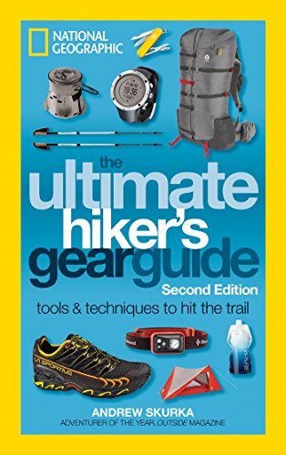
- Spend $8 on https://smile.amazon.com/Ultimate-Hikers-Gear-Guide-Second/dp/1426217846/ to learn everything in between.
- Just go. You’ll learn more by doing than on r/
- Always buy your pack last, after you know what it’ll carry. Watch YouTube DIY vids about, and have a friend measure, your torso & waist dimensions.
- Always buy shoes first - professionally fit your shoes + insoles + socks at REI or a running store. Spend a full hour trying on many combos.
- Spend $8 on https://smile.amazon.com/Ultimate-Hikers-Gear-Guide-Second/dp/1426217846/ to learn everything in between.
- Just go. You’ll learn more by doing than on r/
My notifications were all weird, but here we go:
I print the portions of the map that I need on rite in the rain paper. You have to use a laser printer to print on it though. It's worth it. You can pull that stuff out in the middle of a downpour and work with it, let it get wet, nothing will happen to it, you can even write on it in the rain.
Alternatively you can do it Army TRADOC style and just print it out on regular paper and then laminate it just in case it gets wet, but it seems like a lot of work to produce something you may never use again.
The best way is the dedicated tick removal tools. Tiny spoons with a segment missing. You slide them under the tick and lift up. No risk of squeezing tick guts into you.
https://www.amazon.com/TickCheck-Tick-Remover-Spoon-Carabiner/dp/B07K4F66LH
The only underquilt that u could have by Saturday would be an eno underquilt because Amazon has them they have one called the ember 2 but it isn't very good only good to 50. Eagles Nest Outfitters - Ember 2 Under Quilt, Lime/Charcoal https://www.amazon.com/dp/B00MU2HWMA/ref=cm_sw_r_cp_tai_KizvxbQHH1HQ2
I got mine from Amazon, but i'm sure you can find them at places like bed,bath&beyond or even probably CVS/wallgreens/etc. I'll try and remember to let you know how mine held up tomorrow.
Packrafts from Supai Adventure Gear are pretty commonly used by people crossing the Colorado river inside the Grand Canyon. They are cheaper and lighter (but less capable in whitewater & less durable) than Alpacka rafts, and should work fine if the place where you cross the river is calm. You'll need some cheap paddles too, of course.
For a cheaper but heavy option, I have heard of people using inflatable boats by Sevylor, like this one. The advertised weight on Amazon is ~7 pounds, compared to ~1.5-2 pounds for the Supai rafts, but they also cost a lot less.
If it were me, I think I'd make my decision based on how much other weight I needed to carry. If you're already going to have heavy packs, maybe it's worth the money to get a much lighter and more packable raft...I own the Supai Matkat raft and personally think it's pretty perfect for things like you want to do, but it's definitely not cheap.
Bought the physical map on Amazon and scanned it. Great Smoky Mountains National Park (National Geographic Trails Illustrated Map) https://www.amazon.com/dp/1566953014/ref=cm_sw_r_cp_apa_sBYKyb1ABXKWY
Agreed with the Amazon sales. Everytime I notice one at a good price I buy a pair (or two).
Looking it up, the String Bikini has some options available for $7 (might just be white?) Link!
The stove is legit. I've boiled over 100 cups so far this year. You won't regret it.
The pot is unnecessary. The heat ring does improve efficiency, but not enough to notice. Maybe if you had to melt snow for all your water on a month long expedition. Instead, get this 2.6oz, 660ml pot from Amazon for a couple bucks: https://www.amazon.com/dp/B004444XMY/ref=cm_sw_r_cp_apa_HCx0zb52S1YB7
Okay so that's very common. There is an American version (always with daypack) and a European version (without day pack)
It looks very similar on amazon, and people get confused. This is the direct link https://www.amazon.com/dp/B01IJK1OIY?ref=yo_pop_ma_swf
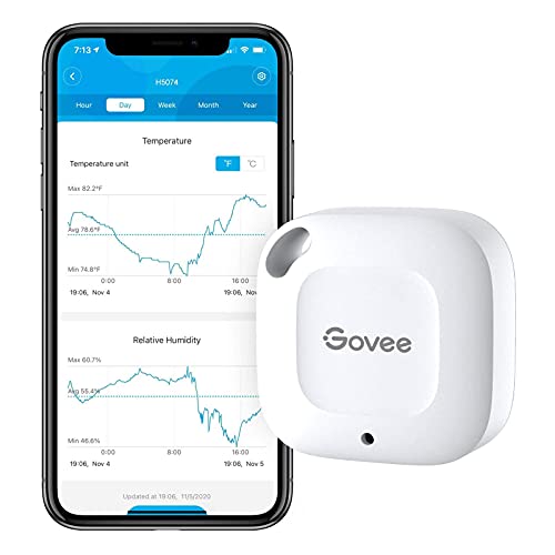
I use the Kestrel Drop 2 data logger but there are others, like the Tempo Disc that are cheaper on Amazon.
​
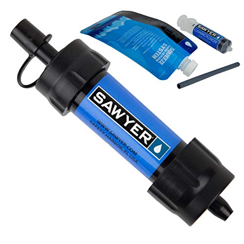
Like pretty much everyone else, Sawyer squeeze for filtration. I finally got a CNOC Vecto bag this year for it, and its a gamechanger. I've also got a cheap coupler so I can use my smartwater bottle to backflush it (the coupler also comes in handy for just hanging bag+filter+bottle and letting gravity do the work).
I'm a sidesleeper, and I'm usually cold - the NeoAir X-Lite is by far the warmest and most comfortable sleep pad I've ever had.
Stove-wise, I just use a tiny, folding 25g titanium screw-on FOME stove I bought on Amazon. I only use a 600ml titanium mug as a pot, so it doesn't take much fuel to bring water to a boil. This is my third year with that stove, and I absolutely love it.
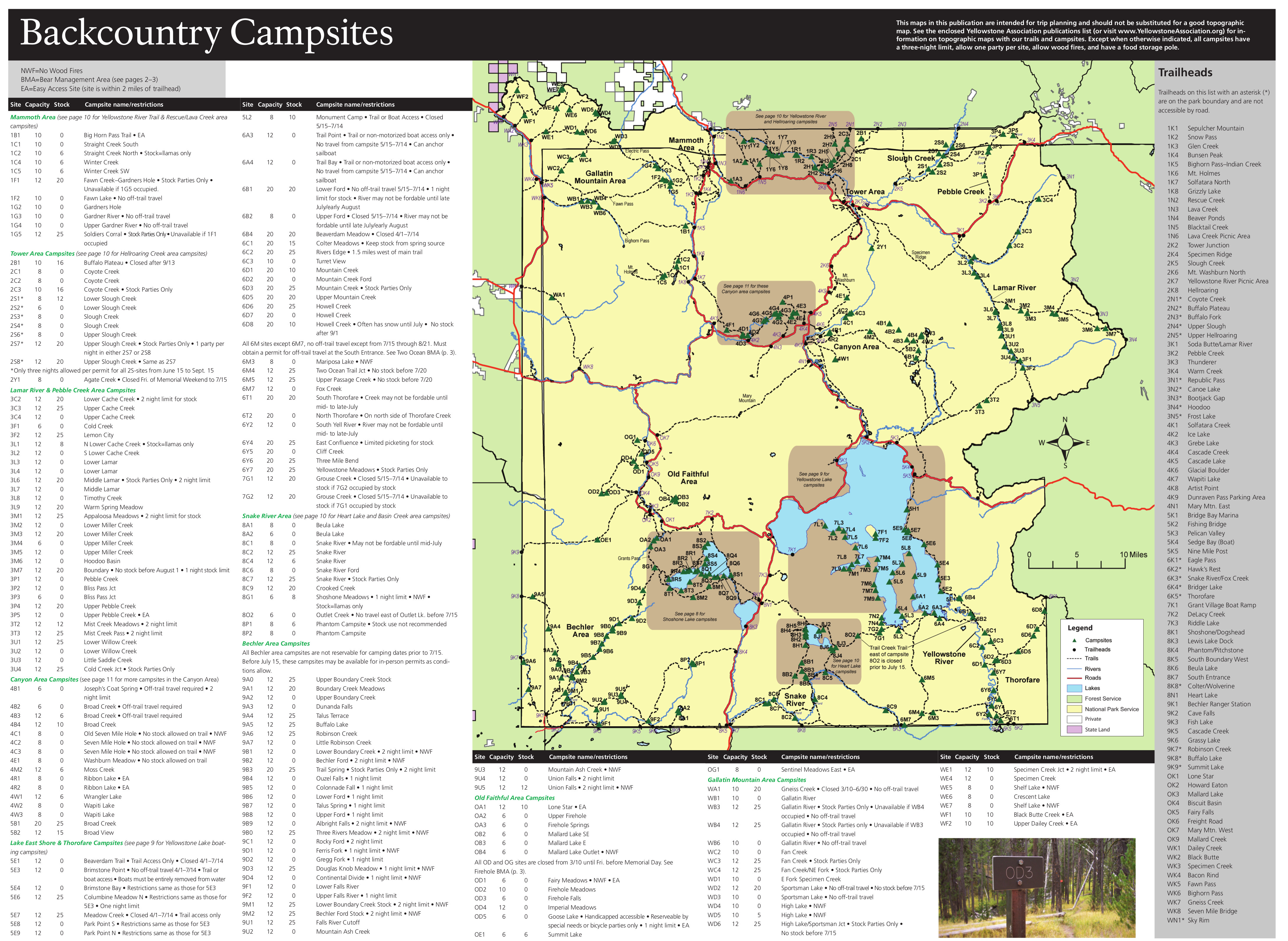
Yellowstone is a choose-your-own adventure place, having someone serve you up a route takes out half the fun! That being said I know it is a huge area and the prospects of planning a trip there can be intimidating. There is a lot of information available online that can help you get started.
The 4 points on your list above are kind of funny because I'd recommend a different quadrant of the Park for each of those.
- Remote : SE quadrant - The Thorofare is the most remote region in the contiguous 48
- Mountainous : NW quadrant - The Gallatin range is the most mountainous section of YNP
- Wildlife : NE quadrant - The Lamar Valley is one of the premier wildlife areas in all of North America
- Geyser : SW quadrant - A lot of backcountry thermal areas are off-trail but in the SW quadrant you could go by Lone Star and the Shoshone Geyser Basin on-trail
Taking a look at the backcountry map and playing around in Caltopo will quickly get you familiar with the trail system, at least in the sense that you will be able to spot the areas in which a 50-mile trip will be possible. In my opinion most of the trail system isn't really conducive to long loops like that. Hitchhiking is easy in the park, especially for a very small backpacking group, an out-and-back could be a great option.
Once you've used online resources to narrow down some route ideas the Yellowstone Trail and Backcountry Guide is very valuable for specific information on trails and campsites.
Maybe begin your search by looking at a route around the Heart Lake/Snake River areas with a jaunt up to Mt Sheridan. Hope this helps you get started!
Katadyn BeFree 3L!
Initially I was pretty annoyed at how difficult it was to get the BeFree to fill my water bottle. Either I had to hang it really low for the water to drip into the bottle or hold it perfectly over the top. To fix this, I also purchased this adapter (ironically made by Sawyer), that fits on the end of the BeFree filter. I then attached a small bit of tubing from the hardware store. When I use it, I place the tubing into my water bottle. That way I hang the BeFree and don’t have to watch it while the water filters.
I got the method from this blog post!
I will always recommend the Klymit Static V sleeping pad. I have the luxe insulated (for the wide) version but the standard one is on Amazon for $36 right now.
https://www.amazon.com/dp/B007RFG0NM/ref=cm_sw_r_apa_i_yrIMEbJ6VRTXA
I've slept on mine for 7-10 nights, I'm 330lbs, and I don't touch the ground when side sleeping. I LOVE this thing.
Hopefully the link below works, but I got that solar panel a few months ago. It's super light and works like a charm. I've taken it backpacking and store it right up against the back/frame of the backpack to minimize flexing. The solar cells are encased in some type of plastic that's reasonably sturdy but flexible
The only annoying part is that the USB output port kind of awkwardly sticks off the corner.
I generally use it in tandem with a small battery and have been happy with it. I still need to test the actual power output to get some hard data
Lixada 10W High Power Paper Shaped Mini Portable Monocrystalline Silicon Solar Panel Charger USB Port for Cell Phone Camping Riding Climbing Travel Outdoor Activity https://www.amazon.com/dp/B06Y655DJD/ref=cm_sw_r_cp_apa_i_YkSHCbCAF23ET
If you're on Android (which solves your GPS device problem as well), there's an app called Locus that I have been using for years. It allows planning, recording, saving maps for offline use, etc. It's served me well for hiking, geocaching, and driving. I think the full version is a one time $5 charge. Totally worth it.
Edit: Locus Maps Pro. It's actually $7.50. Still worth it.
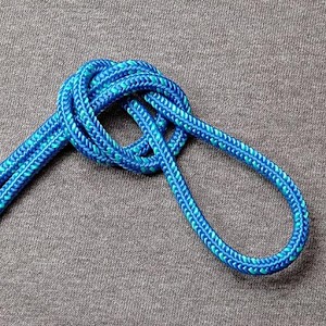
Farrimond Friction Hitch is a favorite of mine right now. It makes an adjustable sized loop that is very useful for tensioning lines. It's very similar to a prussik. Easier to tie and untie than a rolling hitch.
Other favorites:
Siberian hitch for fixing a line to a point with a quick release.
Constrictor knot for bundling.
Trucker's hitch is great if you need mechanical advantage to produce a very tight line.
Easy to tie classics that you'll find yourself using a lot: Bowline, clove hitch, sheet bend.
I also highly recommend the app KnotsGuide., which is available for both android and iphone.
Android? I just used Backcountry Navigator on a four day trip, and I was impressed. I downloaded the topos I wanted beforehand and was good to go.
Rain skirts / rain kilts
This is the one I use:
https://www.amazon.com/gp/product/B07RKSZQTG/ref=ppx_yo_dt_b_search_asin_title?ie=UTF8&psc=1
I'm happy with it's simplicity, minimalistic profile, and functionality.
I have multiple herniated disks in my back, and I'm a side sleeper. I use this mattress, with good results. https://www.amazon.com/gp/product/B07WRD3VVT/ref=ppx\_yo\_dt\_b\_search\_asin\_title?ie=UTF8&psc=1
Lab wash bottle as a bidet. You can get a heck of a lot of water pressure going. I cut the narrowed part off, and widened the bore a bit with a small drill bit.
If you're going to plan to potentially got 12 days or more between resupply I'd suggest packing a few NRG-5 style ration bars for emergencies. I usually take a package or 2 with me just in case. 2400ish calories, 72g of protein, and are vitamin fortified. At about half a pound each.
The stuff isn't actually all the bad to be honest. Similar in flavor to shredded wheat with a little bit of sweetness. Mix with water and some dried/dehydrated fruit and makes a decent breakfast porridge.
Connecting a few cables could take 20 minutes. Otherwise, you're just waiting on shipping. The most time consuming thing will be shopping for the parts that meet your power demands.
I built mine to go in/on my car so I can hike all day and come back to charge stuff up and watch a movie or two. This seemed more relevant to what OP is trying to do - living completely off grid and having access to a computer.
I realize this is a backpacking sub so I'll assume most people just want to bring a phone/GPS/watch so they can stay in touch and watch a few movies at the campsite.
Small electronics like a phone/GPS/watch will just needs some DC power which simplifies the whole thing, and you're better off just buying a small prebuilt thing like this (although I've never heard of that brand). Strap it to your pack and, assuming the specifications are all accurate, it should be able to charge fully in ~16 hours of direct sunlight. You likely won't burn through all the power every day so you could pretty easily maintain a solid state of charge while you adventure.
This blog looks to cover just about everything.
I am about to finish putting together my own. The total cost was $350 for a complete setup including a solar panel, charge controller, battery, inverter, and cabling yielding 650Wh of usable stored power and constant charging throughout the day with a panel.
Compare this to popular commercial brands. The closest capacity Jackery power station has a usable capacity of 518Wh for $449. That does not include panels or cables.
I’ve posted this brand before and didn’t get any shade thrown my way, so I’ll say it again - cheap, Oranginer shoes off Amazon. I have flippers for feet, as in cannot wear shoes that are not Crocs or 4e.
Oranginer Men's Minimalist Shoes... https://www.amazon.com/dp/B081T7KJTP?ref=ppx_pop_mob_ap_share
It's going to be tough to find something that fits your criteria, especially as multiple areas in Oregon have fire closures in effect from the wildfires late last year.
I'd suggest checking out https://www.alltrails.com/ and see if you can find something using the filters. The most common ones will be Mt. Hood, Three Sisters, and Crater Lake Rim, but all of those are going to have snow in April. There are some in eastern Oregon that may work, but getting out there is quite a drive.
Here is the All Trails information. We didn’t do this hike but this will get you in the general area. I didn’t plan the trip and as far as I am aware no permits are required (correct me if I am wrong).
Check out this trail on AllTrails. https://www.alltrails.com/trail/us/california/mount-eddy-trail
There's no cabins or anything like that. It could be done as a day hike though. It's around a 10 mile round trip to the lakes and back out.
https://www.alltrails.com/trail/us/oregon/seven-lakes-basin-and-sky-lakes-trail
this is a little longer than All trails shows but i have done it a couple of times and its awesome
https://www.alltrails.com/explore/trail/us/colorado/capital-creek-loop-to-haystack-mountain
I bought this bag for my trip to WA this summer. Worked well up at elevation where it got down to about 7 Celsius at night. I didn't actually use it as a mummy bag either. Just as a blanket while sleeping on a 3 inch(7.6ish cm) self inflating mattress.
Obvious spam, but these , are the best headphones in that price.
The most help I can be is to recommend you the latest edition of 'Backpacking Washington'. We reference it every season, even after I've become familiar with a lot of the trails across the state.
Not yet... but this push is coming. Read up on the Republican party position on transferring public land to state ownership: https://www.npr.org/2016/10/19/498427493/heres-one-controversy-you-may-not-hear-about-in-the-last-trump-clinton-debate
When hiking you can use liner socks and another pair of socks. Liner socks are very thin and silky. It can feel like your getting blisters but don't. Farthest day hike in them was 40.5 miles and no blisters.
Examples but not exactly like I use.
https://www.amazon.com/hiking-liner-socks/s?k=hiking+liner+socks
Mine seem a bit more like these in terms of knit and fabric. Mountain equipment coop might have some good ones.
- Always buy your pack last, after you know what it’ll carry. Watch YouTube DIY vids about, and have a friend measure, your torso & waist dimensions.
- Always buy shoes first - professionally fit your shoes + insoles + socks at REI or a running store. Spend a full hour trying on many combos.
- Spend $8 on https://smile.amazon.com/Ultimate-Hikers-Gear-Guide-Second/dp/1426217846/ to learn everything in between.
- Just go. You’ll learn more by doing than on r/
May I introduce you to burrito tortilla wraps. A lot of your meals can be eaten on 1-2 tortillas. About 200 calories each for the largish ones. So 400-800 calories per day by eating 1 or 2 with each lunch/dinner. I've even been know to just eat them as a snack with some cheese sauce or plain.
A bigger variety on the snacks. Eating the same thing day after day, especially when you're under extra stress hiking, makes it's easier to decide to skip eating them.
I also switched from ramen noodles to Yakisoba last year. Tastes a lot better, 100 more calories for the same weight. The one downside for backpacking is they aren't salty. They actually are a slightly sweet. Also you don't swamp them with water like ramen. Just 1 cup of water per packet and it should just be noodles and sauce once it's soaked up all the water. Though I do also find they go well with dehydrated/freeze dried veggies/meat/mushrooms and butter as a noodle soup base.
I also like the BelVita breakfast biscuits. Good way to add about 230 calories to each breakfast for not too much weight.
I keep hearing about the Aquamira stuff, how is it? All I have is some oldschool 2 part Potable Aqua tabs (Tetraglycine Hydroperiodide and Ascorbic Acid). Luckily never had to use them before.
Echoing others saying mittens over gloves. I worked for years as a ski lift operator in temps that would get down to -30F. Never found a single glove that kept my hands warm enough, but mittens did the trick- from the cheap Kinco’s to more expensive Gordinis.
Hand and feet warmers work wonders. I’m also someone who just suffers from cold extremities, always have been despite being “conditioned” from the time I could walk by a father who loved ice fishing more than anything. The disposable ones are probably best for the feet but I’ve had the same reusable hand warmers since I was a kid that you can refill the fuel on.
When you go to sleep, pour hot water in a nalgene or two and put it in the sleeping bag.
I also have these winter boots if you can manage to find a pair, they’re a pain in the ass to get on but they’re the warmest I’ve ever had, just gotta keep a layer of snow seal on them.
>I don’t own a headlamp but maybe I should.
https://www.amazon.com/gp/product/B01MTMYY75/ref=ppx_yo_dt_b_search_asin_title?ie=UTF8&psc=1
1.6 ounce and rechargeble.
- Always buy your pack last, after you know what it’ll carry. Watch YouTube DIY vids about, and have a friend measure, your torso & waist dimensions.
- Always buy shoes first - professionally fit your shoes + insoles + socks at REI or a running store. Spend a full hour trying on many combos.
- Spend $8 on https://smile.amazon.com/Ultimate-Hikers-Gear-Guide-Second/dp/1426217846/ to learn everything in between.
- Just go. You’ll learn more by doing than on r/
"Living off the land" is nice and romantic in theory, but turns out to be somewhat more challenging in practice. Read <em>Into the wild</em> by Jon Krakauer for a nonfiction account of one young man who starved to death trying to do just that.