
What are
/r/transit's
favorite Products & Services?
From 3.5 billion Reddit comments
The most popular Products mentioned in /r/transit:


The most popular Services mentioned in /r/transit:
Inkscape
The Verge
Affinity Designer
Wikimedia Commons
Flaticon
OpenStreetMap
Mapy.cz
Rome2rio
Zapier
GeekWire
The most popular Android Apps mentioned in /r/transit:

GPS Status & Toolbox

Transit: Real-Time Transit App

Mini Metro
The most popular reviews in /r/transit:
Yeah, for no reason at all I was looking at rail around Chicago some days ago, and it is evident how flat the land is because there are so many straight tracks. So I would assume that with such straight tracks you already have trains doing something like 250 km/h on them. But .... no.
https://www.openstreetmap.org/#map=8/41.150/-85.515&layers=T
I think your map wants to put stations along a pearl necklace too much. If you could create a train connection between Chicago and Detroit in 120 minutes, that would be really competitive. If I ask google about flights it says it is 20-30 daily and it takes one hour and its two hours to transfer to/from city centers.
If I measure some straight lines from Chicaco-Toledo-Detroit it is about 440 km, and to do that in 120 minutes you need an average speed of 220km/h which is really fast between stops, but within reach. Add more stops and you ruin it and maybe train wont have an advantage over flights.
Only reason I added Toledo is because it seemed like a good stop for another connection Toledo-Cleveland, or Toledo-Columbus, but I do not know what makes economic sense. But think network of HS, and don't be too fooled by the word "corridor". The magic of HS is for trips that take 1-2 hours, not ability to spend a day on a train and cross US coast to coast.
Also it seems really expensive to build high speed rail through the appalachians. To reach east coast it is probably better for Detroit to connect into canada and back into US above the appalachians. I got it to be 1000 km to route Detroit-Buffalo-Suracuse-Albany-New York. It is not an appealing route to do in HS if you compare to flights, and HS is expensive. But as a night train during 7 hours its 142km/h in average speed. That might be doable by just upgrading existing rail, and end up with a train ticket that is in level with the flight tickets.
Hunter Harrison is the CEO of Canadian Pacific Railway (CP). He was also, oddly enough, the CEO of Canadian National Railway (CN).
Harrison was installed as chief of CP after a shareholder proxy fight instigated by Pershing Square Capital, details of which you can Google if you're interested. But the basic reason is that Harrison achieved significant operational efficiencies at CN, and Pershing wanted him to do the same thing at CP, and he has.
Whether that achievement has been for better or worse is debatable. I have a source at CP that says Harrison's demands on the workforce are unreasonable, and that some cuts come to the cost of regular maintenance that will bite the railroad in the ass.
Nonetheless, the rationale seems to be Harrison can now bring operational efficiencies to Norfolk Southern (NS). Problem is this is being pitched as a merger, which will upset the general balance of Class I railroads in North America: CN and CP in the north, BNSF and Union Pacific in the west, and NS and CSX in the east.
CP has been pushing other benefits for the merger, such as easing Railway congestion in Chicago, but its all secondary to the main goal of cost cutting and market power.
edit: If you want to see CP's case for the merger, they've been pushing hard on LinkedIn.
Hi there, thanks for your question!
I use Inkscape, which is a free vector graphics software that (for me) runs well and is reasonably intuitive to learn.
For these maps I tend to use a PNG background for geographic reference, which I trace over. Sometimes I also trace metro lines over existing maps of the current Auckland rail network, using it as a basis or reference for line and station spacings.
I haven't tried drawing any, but the Transit Map Blog did have a post from someone who had used Affinity Designer to draw their fantasy map.
I guess that information might be useful for this thread.
Inkscape might be good for a drawing app, it's open source too so no purchase cost.
I've also heard of people using Affinity Designer to draw transit maps.
In 2015 the car average per mile was 4700 BTUs.
Going from 4700 to 571 with an EV is an 88% reduction in operational energy. More broadly
>Lifetime emissions for an EV in Europe are between 66 and 69 percent lower compared to that of a gas-guzzling vehicle, the analysis found. In the US, an EV produces between 60 to 68 percent fewer emissions. In China, which uses more coal, an EV results in between 37 to 45 percent fewer emissions. In India, it’s between 19 to 34 percent lower.
>It’s important to note that the study assumes that the vehicle was registered in 2021 and will be on the road for around 18 years. Study authors ended up with a range of potential emissions reductions for each region by looking at the energy mix under existing policy, as well as projections from the International Energy Agency for what the future electricity mix will look like as climate policies develop. But it’s difficult to predict how much the world’s energy infrastructure will actually change. For example in the US, President Joe Biden has set a goal of getting 100 percent clean electricity by 2035 — but still needs to pass the policies to make that happen. The study also doesn’t take into account other non-climate related environmental effects that constructing the cars might have from things like mining and waste.
However small or large a role cars will play in future transportation, their future is mostly electric. Compared to combustion cars, both EV cars and rail have low energy usage per passenger mile or kilometer.
It could confirm what we already know, or we could learn new stuff. That's what's great about experiments.
And bridj is hopefully is building it's service in a way it could finance what's needed to scale.
>> although I don't know that it could ever scale enough to have a big dent in a city's transit patterns.
There's a phenomena among gen-x(?) of not really wanting to get a car. Maybe a combination of bridj and uber-pool would be good-enough for them and cheaper than a car. Combine that with the benefits of free time to surf/read/sleep while someone drives you might make a lot of this generation become accustomed to not driving to work and prefer it.
And even that would have a huge effect on city traffic patterns.
rome2rio.com is an excellent website. Here are directions: http://www.rome2rio.com/trip/LosDdh
You would need to take a ferry from Panama to Cartagena, Colombia. Otherwise, it's mostly buses, except for a train in the US between Los Angeles and San Antonio.
But what about all those folks that spent horrendous amount of money to buy the super expensive overperfoming car with top speed of 300 % of maximum allowed speed? Has anyone thought about them? /s
In all seriousness, folks like this are preventing this area in our city becoming a pedestrian zone only. Despite the fact it is the main hub for trams and for trains (both local and international). Despite the fact there is a route around this part. Despite the fact this area is right next to historic core of the city and because of all the traffic it is the most hated part of the city.
But no, the car always has to get through, right? Don't get me wrong, I like driving a car (or a truck as in /r/trucksim), but the how we ended up in this car worshipping era is beyond me.
sorry, this isn't what you are looking for but the South Lake Union Line is a street car in Seattle and its nickname is the South Lake Union Trolley. so people made shirts like this:
https://www.amazon.com/S-L-U-T-Apparel-Ride-the-T-Shirt/dp/B07BW56X53
which I find hilarious.
if you are above ground, there are a number of gps speedometers you can download for your phone. I've used this one for years and like it, but I'm sure there are other good options https://play.google.com/store/apps/details?id=com.eclipsim.gpsstatus2&hl=en_US
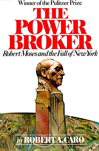
This is a more speculative post than we usually see from Mr. Elkind. Would recommend his book - https://www.amazon.com/Railtown-Fight-Angeles-Metro-Future/dp/0520278275 - for those who are interested
It was a comment meant partly seriously (see my other comment about CH₄; I'd welcome a reputable source that says that CH₄ quantities in permafrost and below the oceans are actually in the "known" category and not in the "unknown" category), and partly as a tongue-in-cheek reminder that there's more at stake here than whether this single new transportation option proves viable or not.
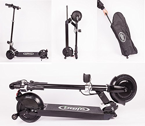
I'd really like to read a study about the impact of scooters on existing transit systems but I'm sure it's still too early for that. At one point I considered getting one myself as there are some very compact models out there. Having one that I could fold up and take onto a bus would really increase the effective range of my city's bus system (for me, anyway). I don't ride the bus often, but having one similar to this -- which has the incredibly simple design advantage of an extendable handle for wheeling while folded -- would change that. I still think about it.