
What are Reddit's favorite GPS Navigation Apps?
Google Maps
Ride With GPS
Waze
MapMyRIDE
Citymapper
OsmAnd
MapQuest
Mapy.cz
Yandex.Maps
MAPS.ME
Magic Earth
Organic Maps
Locus Map
CoPilot
NavIT
Navmii
Google Maps Navigation
XCSoar
Sygic GPS Navigation
MapFactor Navigator
MAPS
Maverick
Top Reddit reviews mentioning GPS Navigation Apps:
She has mental problems. She pretends that it never happened. She also denies getting wasted and forgetting to pick me up at Karate when I was 12. I walked three miles in the snow at night , in sandals and my karate gi, in January in Colorado. She showed up at home three hours later, puked in the hallway and passed out.
She is different now, but refuses to acknowledge what a shitty parent she was.
Edit: Spelled gi correctly. Also looked up the exact distance. It was actually 3.5 miles
That's Plaza Cleaners in Portland, OR. It says Plaza Cleaners on the sign inside the door. It's located at 909 NW Everett St. You can even see the sign in the window HERE.
Not Elite Cleaners, not Minneapolis. Sorry. I know this came from that buzzfeed post going around, seems like they made shit up.
imagine being the google maps driver for this area, i can't believe how bad this place is
i had no idea ~~parts of philly~~ camden was this bad.
I didn't actually know. I just checked Google Maps for crossroads in approximate distances from the places shown in the picture. The first guess was 10 kilometers off, the second crossroads was a direct hit. (There isn't many big roads / crossroads in Lapland.)
Helped being a Finn, though, since knew where to look at.
FAKE!
Just kidding, it's real. Still not sure what he is, but - in another shot, you can see a "CWF" on the back of his getup. South Africa seems nice.
This is in Norway. Reine in Lofoten.
Although this image has most definitely been altered either on camera or afterwards, I was there in February 2011 during the solar storm, seeing some of the most amazing northern lights I've ever seen and this place is absolutely breathtaking.
THERES PLENTY MORE MONEY TO MAKE
FIGURE THIS OUT AND PREPARE TO MEET AGAIN
JULY NINETEEN
FIFTY SIXTH AND SIXTH
HOT DOG STAND OUTSIDE RUE CAFE
ASK FOR MISTER INPUT
Here's a link to the meetup location.
EDIT: Thanks to rophel for pointing out that it should be the Rue57 cafe.
Actually, I know exactly where this is, and sorry to say, but this is most likely private property. Note that the red building in the background is Kildare's, though it used to be McFadden's, which can be seen in the google maps link that I provided.
It's a business area with a lot of bars at the south end of Ohio State University that is often patrolled with many police officers and it's not uncommon to see people being kicked out or even banned from this area. My friend was banned for mindlessly pulling some leaves off of one of the trees (the same trees you see the guy leaning against in the video).
I'm pretty sure what you linked to is a run of the river hydroelectric generating station, not any sort of mining operation. Your screenshot was taken here at what seems to be the outlet of the hydroelectric plant. If you move the map a bit farther upstream, you see the inlet to the hydroelectric plant here
Notice how the water going into the dam in the second location is the same colour as the water going out of the plant in the first location (your picture). Also, if you go to street view, you can see loads of power lines going away from the generating station and an old pelton wheel on display at the entrance.
That actually looks more like the White Castle in Brooklyn on Myrtle Ave, Near Washington https://maps.google.com/maps?q=white+castle+near+Myrtle+Avenue,+New+York,+NY&hl=en&ll=40.693736,-73.963534&spn=0.007012,0.016512&sll=40.702217,-73.921288&sspn=0.007044,0.016512&oq=white+castle+myrtle+av&hq=white+castle&...
SO! After some research I have concluded this is in fact not in Detroit. Notice the similarities between the sidewalks, The front of the white castle, and the building in the background, as well as the location of the Dumpster in the mid right third. I live near this white castle, IT IS MOST CERTAINLY NOT DETROIT.
Also chances are this wedding party actually took place at the bar next door, which is predominantly populated by the ethnic group you guys are referring to, in a grotesque and disgusting way IMO. It's called Bamboo Lounge.
OP. YOU FUCKED UP. How did no one notice this until now?
I think this is it: http://i.imgur.com/UsJQ8.png. Here's the Google maps link.
Here is the Google
> On mobile Firefox if you search thru Google for a address you cant click the link to the address take you to Google maps and continue from there.
That is why I have ceased using Google Maps. For navigation now I use OSMAnd. I especially like the fact the maps can be offline as it means I never miss a bit when driving through poor service areas.
Nobody has mentioned the WTF is this guy doing?
I'll raise you one better: Google Maps has a 360 degree panorama of the hut!
Friendly google maps link! of a guy buying drugs in Flint. poor google street view team. they were so young too.
You can see the actual colours on this site.
You can see the red colour on the boats on Google as well, which suggests to me that it's some kind if camera error.
I think they were done with the scene. Go up the street a bit. Figured this out because I noticed the car going from left to right so it would have been recording them before the point in the original post.
I love the fat guy in the tank top and his reaction in the drive by. "Hey, is that th... HEY GOOGLE!"
Then the one guy giving the google car the death stare.
edit I HAVE BEEN NOTIFIED THAT HE IS WEARING WHAT WE CALL A TSHIRT. THANK YOU
If we check here in a few months, we'll get to see the OP!
Took this picture in downtown Atlanta a while back, it's an apartment building next to the library.
Found it!
Here: link
Already been done (kinda).
With added scuba gear!
This is less of a case of “ugly building” and more of a case of “construction is ugly”.
The building is still not finished, and will look much nicer when finished.
Here is the building next door from the same complex of buildings. The new building will look the same since all buildings in that complex are supposed to look like that.
Something else mildly interesting. Teds Luncheonette in Largo Florida is where parts of this scene were filmed.
I like to go there for my birthdays to have breakfast, the inside is pretty different, but there are still pictures of Samuel L. Jackson, Tim Roth, Quentin Tarantino, etc on the walls. Plus they make some awesome food too.
Ok, some facts:
1 - This is the Insano water slide at Beach Park Fortaleza.
2 - It's not really new, I think it was built around 1995-6.
3 - I don't think there's ever been any serious accidents there. Aside from getting the wedgie of the ages you're pretty much safe.
4 - I've been there in 1998 and holy shit it's a great feeling.
This neighborhood looks like a charming place to live...
Someone in the last thread suggested calling these Pubstomps and I think that's fucking brilliant. =)
Either way, now's the right time to get in touch with your local Barcraft and see if there's any interest among your community. Even if it ends up just being a poll with an overwhelming "not interested", do your part and give it a shot!
EDIT: Here's a map that has links to all of the BarCraft communities: BarCrafts around the world!
Very interesting. Here is the island on google maps, for those wondering... https://maps.google.com/maps?q=Tromelin&hl=en&ie=UTF8&ll=-15.891705,54.528397&spn=0.022412,0.042272&sll=44.145447,-120.583402&sspn=4.280591,10.821533&t=w&hnear=%C3%8Ele+Tromelin&z=15
Try looking around here.
Found it in Street View
For the lazy or on phones: http://imgur.com/Lvp0j
I'm sorry, but you can drive there, so it must be close. ;)
If it doesn't load or takes too long, just get directions from Singapore to Beijing, China using Google Maps - it's pretty funny.
Safest Street in Camden. The Goolge Maps drive probably left the doors unlocked as well. https://maps.google.com/maps?q=camden+aquarium&hl=en&ll=39.953588,-75.119947&spn=0.000916,0.002064&sll=39.925996,-75.107517&sspn=0.058647,0.132093&gl=us&hq=aquarium&hnear=Camden,+New+Jersey&t=h&fll=39.94856,...
There are no large predators in the waters of the great lakes. Try doing the same thing in ANY body of water in Florida. We used to go to swimming at this lake when I was a kid/teenager. I've been to the bottom out in the middle, which is roughly 25 ft. deep. I've also been swimming in that lake at night on multiple occasions. Stupidest thing I've ever done. We'd pull our cars up to the side of the lake and shine the headlights out over the water to see the yellow reflections off of the eyes of the handful of alligators watching us.
Citymapper. Simply the best transit app/website I’ve ever used. Takes into account subways, regional rail, bike share, light rail, car share apps, you name it. Google maps has gotten better but Citymapper used to be able to find me a faster transit route like 50% of the time. They’re also really on top of delays and construction work too. If you use transit and it supports your city, you should be using it.
This should be higher up. Here's the exact setting on google streetview for the lazy
Apparently this is huge in Pittsburgh and nowhere else, though I guess they've expanded to Miami, in case no one got the reference. And here's the sandwich
OP's friend most likely works at SuperCheap Auto
The Diomede Islands are two and a half miles apart. An ice bridge can form between the two islands in the winter, as can be seen on Google Maps.
And this is, in my opinion, the greatest thing ever built by man. Have a walk around it.
Darn Google needs to learn to clean up, they left secret strategy documents right out in the open.
The checkpoint is in the SB Lanes of 93, between Tripoli Rd. And Waterville Valley. See Waze
If you want to avoid it, I recommend Rte3, from Lincoln, or SR 175, from Tripoli Rd.
Dammit, beat me to that. The other company visible is Westernco Donuts, and you can see the intersection is 4th and something that starts with "M" -- Marginal Way.
What about The Big Android in the Server cage?
This is grass roofed house near Gol, Norway.
Looking this up on Google Maps - oh HELL no. There is no way I would live in the middle of a desert like that.
The Sill is approximately in the middle. There are some houses/buildings (whether occupied or not, unknown) up and down the Birdsville Track. Marree is SSW from The Sill; Birdsville is NNE.
Edit: I love the bush "airports", like Dulkaninna Airport. A long strip of dirt, in the middle of an endless sea of dirt, with no buildings.
Nice, those are all right next to each other in downtown Denver.
I know you're joking, but this is how.
He actually went to my Alma mater, Wheaton College (IL). Supposedly he named the movie after an actual Elm street in Wheaton, IL. I have driven down Elm st many a time. It is your typical suburban street and the perfect backdrop for some horror.
Nay, that's Latvia's capital, Riga.
Actually I don't believe that's the right Shell gas station. There is one closer to Disneyland, on the corner of Ball Road & Harbor Blvd.
Compared to the flickr picture, you can see the Chevron across the intersection, the palm trees to the right and the Shell gas price display.
I drive down Ball Road from time to time and got gas there before.
I live about 50 km from "real" Chernarus, it's based on location in northern Bohemia, Czech Republic.
https://maps.google.com/?ll=50.682809,14.146099&spn=0.047803,0.132093&t=h&z=14
You can clearly see Elekro and Cherno, Mirkov is Mogilevka and Český Bukov is Pusta.
Notice Kozí Vrch, that's Pik Kozlova, mountain between Elekro and Cherno
so, i'm from a lake forest, and there are two del tacos right down the street from each other. he'll need to be more specific if he wants help
the corner of Van Buren and Franklin -- Link to streetview
However, there is now a building on the right.
It's fifteen minutes tube station to tube station. Chuck in a ten minute walk from the o2 to the tube, and from Westminster to the HoP.
On a busy commuting morning, it might be half an hour. 3 hours is what it took me to fly from Heathrow to Moscow.
What one has to keep in mind is that we weren't really in lockdown until Friday when the new restrictions were introduced (we could still go tighter I think, but yeah).
As of yesterday Sydney is at 9% mobility according to the Citymapper mobility index (https://citymapper.com/cmi/sydney) meaning people are moving around less. To compare, last year during Melbourne's lockdown they got to 7%, Sydney's lowest in March was 11%, and Sydney's current is the lowest of all the cities whose mobility data is published).
While recent numbers are pretty troubling (and we can expect them to get worse over the next few days), we will start to see them coming down pretty soon I think. Still, the government has totally bungled this, we didn't need to be in this mess, it's very frustrating! Just don't lose hope, guys. Stay at home :-)
That would be enough to circle Manhattan with werewolf dick about three times and still have two miles of it left over
It's actually not a river it's a mountain ridge.
I recreated the image in Google Earth: http://i.imgur.com/hyYYd.jpg
Here is a link to it in Google Maps (you can see the circles for reference): https://maps.google.com/?ll=33.290542,-103.822453&spn=0.123546,0.138016&t=w&z=13
I get confused by the lights near Cambridge Common (the park, not the restaurant) coming out of the underpass on Cambridge Street, where there's a red light and a green arrow at the same time.
Mountains. When warm and moist air is forced upwards by elevation, storms form.
Actually no it wasn't parked legit. I work in that area.
The driver is a douchebag. He ran over a cops foot because he thought he was above getting a ticket and got arrested. That's justice.
You can try the waze carpool app to see if someone has a similar weekly work route and get some gas money:
Here's the non referral link: https://www.waze.com/carpool
It's here.
Nope. That was Iceland, this is on a small island just North of England, and just West of Norway.
Google allows for people to upload pictures for the inside of businesses or down places which the streetcam car can't do. It's in conjunction with Google Business Photos.
Made me think of the three-way intersection on McGrath highway in Somerville.
This was taken at the Selous Game Reserve in Tanzania. Couldn't tell you what type of giraffe that is though.
Exactly. It's a community driven service, so if people don't report stuff that's wrong, they'll never get fixed.
As well as reporting within the app, users can go to https://www.waze.com/editor/ and amend things, too.
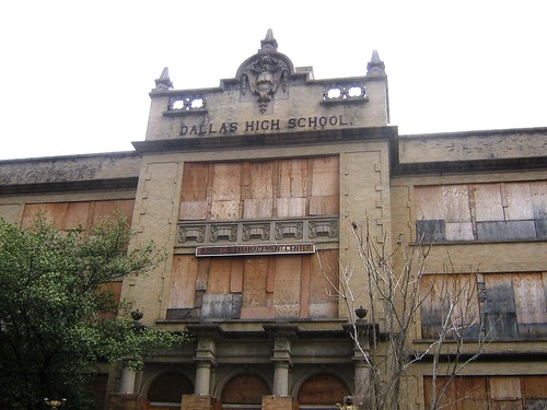
Seeing this old abandoned school reminds me of the old Dallas High School. The building is right in the middle of downtown, was abandoned decades ago, and always looks kind of surreal to me, like a Hollywood set for a horror film. I've always wanted to break in and check out the inside.
http://farm1.static.flickr.com/150/417921697_1deba041ea.jpg
It will be gone soon. A builder has been approved to turn it into an apartment complex.
I have seen these all over the US and Europe, nothing new.
Edit: Several of these on the A1 in Luxembourg.
Edit: Wikipedia on them
A while ago I put together a map showing the area the battle takes place.
Larger version, in case anyone's interested: http://i.imgur.com/sFW4M.jpg
Also, here's what it looks like today, courtesy of Google Streetview. Obviously a lot has changed, but the three buildings that feature most in the photo are still standing. The rightmost building still has a pharmacy, amusingly.