
What is Reddit's opinion of
Google Street View?
From 3.5 billion Reddit comments
100 reviews of this app found across Reddit:
"Alright. alright. Space. What about Space Mr.Anythingispossible"
"Well just give a 360 camera to some astronauts and have them float around."
https://www.google.com/streetview/#international-space-station/
This is actually probably a volunteer, not a Google employee. Google actually rents these things out if you are going somewhere interesting.
As an Alaskan resident who contributes regularly to Streetview using Photosphere on my camera, I've considered applying to rent one of these (Alaska has so much undocumented wonder, and so many people want to see it, but it's very expensive to visit) but I'm worried about some locals desiring to not be on camera.
EDIT: Realized I may make Alaskans sound like crazy coots, which is not the intent. I edited my comment appropriately. Alaska has the strongest privacy laws in the US, all the way to the Constitution level. This is the reason, for example, that the Anchorage man who shot up an airport in Florida had his guns returned to him after turning himself into the FBI with clear mental health issues and seeking help (before going on a spree.) This draws a very certain type of individual who wants privacy and things left off the internet, which I can respect. Nearly any Alaskan you will ever meet is very kind and nonviolent, but privacy advocates are definitely up here in a higher concentration.
It looks like the Local Guide Street View Program is no longer active as of December 2020. Google has a list of cameras you can buy if you want to spend money creating StreetView, it's aimed towards businesses.
If you don't want to spend money and still want to contribute towards building information about areas on Google Maps for your city/country, you can look into becoming a Google Local Guide. You earn points for your contributions and level up. You also get some perks depending on your level that vary on location. This can be anything from extra Drive storage to coupons from other companies or early access to Google products/features.
https://www.google.com/streetview/contacts-tools/
Pretty much they don’t pay people to take the photos anymore (I’m sure by this point a lot of it has been done)
Companies can buy the camera equipment for their productions, i.e. tour guides
Flotte billeder! Har du overvejet at låne sådan en street-view rygsæk til at tage billeder af de ruter du går? Det ville i hvert fald være nogle fantastiske tilføjelser til gmaps :)
Since I am a bit of a Google Earth VR junkie, here is what I have learned. There are 5 different fully decked out street view vehicles. Car, dolly, hand held backpack, bicycle, and snowmobile. The backpack is loaned out upon approved request. Then anyone can become a Google Certified Street View photographer by getting an approved 360x360 camera (cell phone combo) and applying. Google then supplies a free processing app. It takes 50 published photos to get that certification. All specific shot points can be seen on Google Maps by zooming in far enough. They appear as blue dots. Also, other things are besides interiors have been captured. That includes things as ski slopes, popular hiking trails, virtually all non-3D areas. gondola car and ride interiors, you name it. Their stated goal with their certified photographers is to cover everything on this earth that is interesting. They now have over 3 BILLION photos. See this to learn more.... https://www.google.com/streetview/
It's not necessarily a job.
If you own a 360 camera, Google will let you do their job for free. ;)
That's the Google Way!
https://www.google.com/streetview/publish/
Hence, the dog could just belong to the owner who uploaded that particular footage.
Who takes a cab to a trail that maybe hours away from your own location? I mean for some hikers, they would hike the trail regardless of Google, so why not add on a backpack and help document some trails and locations for Google Maps?
More details about the program: https://www.google.com/streetview/loan/
As far as other personal expenses, that just seems odd to even think they would pay for that stuff. I am not sure how much hiking you do, but normally if I go on a long hike, I carry a maybe a light lunch and plenty of water, but asking for reimbursement of less than $5 is rather silly.
Anyone can become a trusted photographer for Google and provide stores with in-door streetviews. A requirement is at least 50 public streetviews/photospheres.
Google has a website where you can see more about this and even see locals in your area that you can hire to do these streetviews.
https://www.google.com/streetview/hire/
Obviously not all types of stores are suitable for in-door streetviews, but I cannot wait until more stores add these photos. It will save both of us a lot of time.
Just got time to google the item. (me don't work for Google, just use them only)
The Official name for this item "Street View Trekker backpack". The Street View Trekker is essentially a backpack with a built-in 360-degree camera, hard drive for data storage and batteries to power day-long hikes. (old model was 18kg, new model lighter, but no numbers provided)
if you wish to loan the device to map some areas, this is the form
https://www.google.com/streetview/loan/
Ps this fellow, is just a contractor (saw his pass) He have to display his Identifications, as some people are sensitive to their image taken.
Privacy Faces (moving objects)
By right, the software would remove faces/moving objects (i.e cars) But the during the capture if the imagery, if the object was spotted at the same location, during the subsequent (when is the subsequent time, no idea) image capture, that image is likely to be in the Google Street view.
It's likely this has been requested from the owner of the house rather than Google blurring it themselves.
"If you see that your face or license plate requires additional blurring, or if you would like us to blur your entire house, car, or body, submit a request using the "Report a problem" tool. Please note, however, that once Google blurs an image, the effect is permanent. If you submit a request to have your house blurred from Street View imagery, all historical and future images of your house will also be blurred."
This is from the streetview website https://www.google.com/streetview/policy/#blurring-policy
Did you ever see the street view of the ISS and how many DSLRs and lenses they got up there? Everybody could be dual wielding cameras and they still would end up with lots of spares.
https://www.google.com/streetview/#international-space-station/
I was selected to go to Local Guides summit 2017, so I got a free vacation to San Fransisco. And it was really an awesome trip, great food, great parties, great people. So because of this trip, I have to say Local Guides is better in my opinion. But only 150 are selected to go to this every year.
Other than the summit. Local Guides gave me a free movie ticket, and free Google Drive storage, and a local guide shirt.
I've also earned money as a Google Trusted photographer https://www.google.com/streetview/hire/ where Google recommends me to local businesses and I get paid to do 360 photos of their business
For Yelp, I've been Yelp Elite since the beginning of 2018 and haven't gotten any rewards or gone to any Elite events or anything yet. But I do have to say that I feel like Yelp's community is better and more appreciative of my contributions. For example Yelp gives me notifications when people like my photos and like my reviews, and it's just nice knowing that people do appreciate them.
I'd recommend just contributing to both. Just save a copy of your photos and reviews and submit them to both.
Here. Just a heads up not every country that’s listed gets published updates (as far as my knowledge that would only be Germany and Finland but I could be wrong)
If you run the Google Street View app on a $200 tablet and load it into a $15 Google Cardboard VR viewer then it is possible to find some spectacular 360deg VR panoramas shot underwater on healthy and diverse coral reefs:
https://www.google.com/streetview/#oceans
Small comfort, I know, but as long as we've still got the juice to keep that level of tech up and running then might as well enjoy it while we can.
​
Nothing. The people taking these cameras to remote locations aren't employees, they're people who fill out an application to borrow the pack. Google doesn't pay for any part of their trip.
https://maps.apple.com/vehicles/ is a list of areas the Apple Maps vehicles will be in.
https://www.google.com/streetview/understand/ for Google Street View cars (There is a dropdown menu below the map for a list of non-US locations).
Most likely because the homeowner requested it—which is pretty easy for anyone to do. From Google Street View’s Image Acceptance and Privacy Policies:
> Blurring policies: […] If you see a face or a license plate that requires additional blurring, or if you would like us to blur your entire house or car, submit a request using the Report a Problem tool. Please note, however, that once Google blurs an image the effect is permanent. If you submit a request to have your personal home blurred from Google Street View imagery, all historical and future images of your home will also be blurred.
There's a bit of a sordid history: https://bits.blogs.nytimes.com/2013/04/23/germanys-complicated-relationship-with-google-street-view/
But the good news is that for a brief moment late last year several German cities were listed on the "where we're going next" page. This guy has a screenshot: https://productforums.google.com/forum/#!topic/maps/OCkSrf-paoY
It's likely that given their past issues with Germany they're taking extra special care with the imagery before they publish it. I would expect it very soon though.
Yup the Steeetview site shows them as mapping Douglas County and a bunch ig other counties through September. My brother’s seen it twice now, yesterday he followed it down Indiana Street for a bit lol
Using data from Streetview website, I drew on the map the minimal coverage that should be published for Kenya. By minimal I mean the listed towns and the major roads between them. Since they actually listed regions and not towns, maybe they'll cover more (I hope so). But looking at the coverage for Ghana, Senegal and Tunisia I'm not sure they will cover a lot of things.
As you can see it will probably miss a big part of the country in the north (which is emptier, and probably security concerns near Somalia and South Sudan). I think we can also expect some trails in Mount Kenya NP since they covered towns around it.
For interested people, the data I found is HERE.
This is the file that list all locations (past, present and few future) where Google sends cars. You can find interesting things there, like India (which was planned, but Indian government blocked the publication of pictures) or new Austria coverage. It's used for the list visible on https://www.google.com/streetview/understand/ but only lines with the entry ""publish": "Yes" will be in the list.
There is a cache listed in the ISS. Well, technically it's listed in Kazakhstan, but the final is on the ISS. You can even see the locker it's stored in on Street View.
It is certainly a bit confusing that Google has apparently allocated the ISS an Earth surface location of "Bldg 9, Space Vehicle Mockup Facility" in Houston E.g. in the top right here or the bottom left here
But as others have pointed out, I think the imagery we're seeing might be entirely real, in orbit, no mockups.
>View one of the Google Street View locations on your computer and then imagine seeing it in VR instead of on your computer screen.
Google Street View photographers take 2D photos used to create what you see on Google Maps Street View. If you've seen a 360 photo in any headset, you've seen what Street View VR looks like -- whether it's in a Cardboard headset or in a Vive. On your computer you can move around in Street View by clicking with your mouse. In Wander you move around the same way using your controller.
So it's not a 3D experience like you'd find in a game. It's like a virtual tour you'd see in a VR realtor tour of a house or a tour you'd find at Kuula.co.
Google Earth is a different story because it has 3D models viewable on PCVR headsets. Google Earth also lets you drop down to ground level where it switches over to regular 2D Street View -- the same thing you'd see in Wander or on the Daydream headset or in a Cardboard headset.
If nothing else, you'll find an incredible number of places to visit because Google's photographed a lot of the planet and ordinary people have uploaded their own 360 photos into Google Maps. You can see those in Wander as well. A while back I visited Antarctica for the first time. There aren't that many places to visit there, but there are places you can see. I'd speculate that Google Street View has one of the largest libraries of 360 photos in the world. And, in Wander as on your computer, you can "move around" in most locations.
If you're looking for 3D, you're out of luck until Google starts taking stereo Street View photos which I don't know if they'll do even though their newer cameras could make that happen.
4-5-6 years at this point, it's not a part of Google Earth but a branch off of their streetview program -- businesses then get a "see inside" on their Google Business Listing.
That’s the updated Street View model with updated cameras and fixed with 2 LIDAR sensors for 3D imaging.
Official site says they’re driving around Berlin until November.
Well, they aren’t exactly sending employees around: https://www.google.com/streetview/loan/
They lend out a backpack for people to record on their behalf. In other words. They get people to do it for free.
Depending on where you are and where you’re willing to go, you can volunteer and get the equipment from Google. They want walking paths and hiking trails where their normal vehicles aren’t allowed (edit: …and I guess they want business interiors now as well). I was going to do it, but apparently there’s nothing anyone wants to see here. 🤷🏼♂️
They also have approved the Insta360 Pro camera that you can attach to your car and upload to google. Camera is $3500 but Insta360 says Google will also offer 50 cameras through its Street View camera loan program. So if you are going to be going to an area that has not been street viewed contact them. Im probably going to do this next summer when I go on my bike packing trip. There's a bunch of gravel roads I'll be riding on not covered by street view.
Camera Loaner application https://www.google.com/streetview/loan/
More on publishing to street view https://www.google.com/streetview/publish/
Unlike Street View, there is no public schedule for acquiring 3D imagery in Maps.
One thing to keep in mind though is that if your city doesn't have an airport nearby it will be very difficult/cost prohibitive for them to get the imagery needed. It's easy to imagine them solving this problem with drones or solar-powered aircraft in the future though.
On the German version of https://www.google.com/streetview/explore/ you can read:
"Jeden Tag nutzen tausende Nutzerinnen und Nutzer Google Maps und wir möchten dafür sorgen, dass ihr den Weg zu den Orten findet, wann immer ihr es wollt. Um dies zu schaffen müssen wir sicher gehen, die richtigen Straßennamen, Straßenschilder, Streckenführungen und Informationen über Geschäfte und andere Orte, die für euch von Interesse sind, zu verwenden. Deswegen werden wir ab dem 29. Juni 2020 die Fahrten durch weite Teile Deutschlands wieder aufnehmen. Oben auf dieser Seite findet ihr alle Informationen darüber, wo wir gerade sind.
Wir wissen, dass das Interesse an unseren Kamera-Autos groß ist. Es sind dieselben Autos, welche wir in der Vergangenheit genutzt haben, um Bilder für Street View aufzunehmen. Bei den kommenden Fahrten nutzen wir das Bildmaterial aber nur, um Google Maps zu verbessern und haben keine Pläne, dieses zu veröffentlichen."
So if it was a Google car then pictures will not be published in Germany.
If the camera was white with dark spots then it's an Apple car and nobody knows if Apple will publish the pictures. Probably not but if they do then Google will have to do it as well to not stay behind.
you can always go to https://www.google.com/streetview/explore/ scroll down until the "Where we're headed" section, there you can choose a country and they show you in what regions they are working now ( when they started and when they plan to finish )
i have no idea in what region of germany that place you mention is so i will let you look if they are at least near the area :)
> dont like the job? then just leave
yes? it's pretty easy to not "type in <em>google.com/streetview/contacts-tools</em>, buy a 1000 dollar camera, put it on your backpack, walk all over town" if you don't want to.
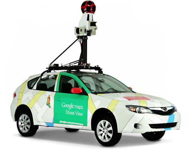
Are you asking how they get the pictures for street view? If so they drive round in a car with a camera on top taking pictures along with the GPS location data then upload them on google maps.
> That's so not true. Many (especially bigger cities have street view).
Compared to other EU countries (except Austria, although apparently they are going to join GSV), it's very limited. Just take a look.
> I think the state should not interfere in what persons believe nor what they wear, besides they are violent or calling for violence.
Exactly :)
He's sitting here https://www.google.com/streetview/#international-space-station/japanese-experiment-module-kibo
I count at least ten. :D
https://www.google.com/streetview/#international-space-station/columbus-research-laboratory This room has even more.
> You'll be able to re-submit them when the portal submissions go live again.
And from here on out, it's probably a good idea to submit a 360 image to Google Maps Street View at the same time you submit the portal.
I believe it was July of 2016 when they had a sort of contest for Parks and Recreation Month where every photo you contributed to a park would enter you into a drawing for a Ricoh Theta S. That's about the closest to a "deal" they've ever come.
You might try the camera lending program. There was a guy on here awhile back that was able to borrow a Theta S from them to do 360 images of some hot air balloon festival.
Everyone's saying that's some sort of google-sponsored thing, but the thing you linked is just a photo sphere added by a google user. You can create photo spheres with just about any camera with the right technology. Google will loan you the streetview backpack under some sort of criteria, though.
Coincidentally, this morning I was looking at a 360 picture of the same place :)
If you use the Google Street View App (freely available for both iOS and Android), you can find even more 360 photos of both the rooftop and the Hall.
Great media experience for those who live far away!
Try to Google for "Street View camera loan program". I couldn't easily find a Google page talking about it so it may no longer exist. But there are lots of articles on the net that mentions the program.
EDIT: All links seems to point to https://www.google.com/streetview/loan/, but that just redirects to a list of compatible cameras available to buy. They may not have the program anymore, or they may no longer advertise it.
They don't publish new coverage in Finland probably because someone else is doing that (low quality) unofficial coverage, I mean it's literally promoted on Google's website...
I think you used to be able to rent/borrow the gear from Google if you wanted to capture a specific area. This is all I can find at the moment though:
Probably takes a bit longer to rack the ks up in a suburb just going round and round each block making sure you get every street.
Looking at the link below they started in July and are ending in December. So they're not running around all day every day.
A car or other system is equipped with cameras attached to a computer that takes pictures regularly, and they get tagged with GPS data as they go. The cars also have LIDAR that measures the exact distance to other objects such as buildings, to allow for more accurate positioning of images. The rest is image processing. Google has a description of the process here.
In addition to visiting specific locations, you can also visit any of these locations that Google has in it's Street View Gallery.
https://www.google.com/streetview/
That gallery is available in the Viso Places app. You can even tour the Space Station, wander around Venice (on and off the water), and tour one of Google's most recent captures -- Disneyland. You can walk around it like you're there. These types of experiences don't benefit from 6DoF but they may be what most people on the planet experience.
With the Lenovo Explorer you can also explore Street View locations using the Google Earth app. But I don't think it has all the features, such as shared experiences and rapid teleportation, that Viso Places has.
Photos and videos are fine, but apps like Google Earth and Street View go a step beyond by allowing you to move around in them.
Google does have a program where you can apply to borrow a free Street View kit: https://www.google.com/streetview/loan/
You may need to get someone from your town or local chamber of commerce to increase your chances.
Google street view has been mapped for the ISS if you wish to see the inside of the station.
It's pretty cool.
Google doesn't save up imagery to release it in one big batch; it releases it when the processing is done. The processing starts right after the imagery was taken. There is new imagery taken and posted daily, with the locations constantly changing.
You can see where they are currently collecting imagery at https://www.google.com/streetview/understand/.
Nicht sehr genau aber in etwa: https://www.google.com/streetview/understand/
(Allerdings sind nicht alle Autos unterwegs um Bilder zu machen. In Deutschland zB werden keine Bilder gemacht bzw nicht veroeffentlicht)
>They will be back in Germany later this year, though. Find the schedule here
Just checked some sources and unfortunately while they will drive around they don't plan to release them, but that may change sometime later. Hopefully
https://www.googlewatchblog.de/2017/08/google-maps-die-streetview/ (in German)
https://www.google.com/streetview/privacy/#service-use
> Reporting Issues
>Request Blurring or Image Removal
>If you find content that you believe violates the Google Terms of Service, the Google Maps/Earth Additional Terms of Service, or these Geo Imagery and Privacy Policies, please report it to us using the Report a Problem link.
>In addition to the automatic blurring of faces and license plates in Google-contributed content, we will blur an entire car, house, or person when requested.
Not sure on procedure. You may just need to use the "Send Feedback" function on Google Maps.
Well right now I'm working on making 50 spherical images for google earth so I can get that sweet street view trusted badge.
From there I want to work towards this because I think it would be amazing.
Idk how long they've been doing this but: they tell you where they're updating and when
I'm sorry yours was a bust. Check your area on that link and get to cruising 😎
Taip vyksta, bet čia nesamones rašinėja, kaip "kasmet fotkina" ar "matė prieš 3 metus". Buvo grafikas paskelbtas,kada eis per lietuvą ir niekas čia kasmet nevažinėja.. https://www.google.com/streetview/explore/
Drifting away a little from my experience here, but I think Google Streetview needs a sequence of still images which you can upload with the Streetview app.
Best to do a bit more research on this - it probably requires some other info such as GPS stamps as well.
This page has Google's recommended devices. https://www.google.com/streetview/contacts-tools/
It lists the insta360 One, rather than the X2...and the GoPro Fusion rather than the Max.
There's lots of competition and you probably won't find free virtual tour software or sites that do everything you won't.
Brodecki listed some of the challenge. One big one is knowing how to place arrows so when someone clicks an arrow they appear to move in that direction to the next pano.
Google lets people take a series of 360 photos and upload them to Street View as virtual tours. There are photographers that can do this or you can do it yourself. However, as Google notes, you'll need to use software or a service to connect your photos. Here's Google's info on that. https://www.google.com/streetview/contacts-tools/
The Unity Store has tools that let you do it all yourself. But those tools aren't free. One of them is over $200.
A less complex scenario might be where a 360 photo only has 3 arrows: show me the next photo, show me the previous photo, let me choose a photo.
Some sites let you navigate anywhere like you can do on Street View. And a site can also show you a filmstrip that lets you choose the photo you want to see.
A final solution might simply be to create a 360 photo slideshow that users can page through.
There are commercial sites that host your tour and help you build them but I don't know of a free one.
Note: Long ago Google did acquire a company that lets you build virtual tours with connected photos. But that only works/worked for web-based tours - not in VR. I can see if that still exists if that's an option. The tool automatically created those connecting arrows based on how you arranged your 360 photos. I'd have to look it up because it might not even be in my bookmarks anymore but I tested it and it worked well - for browser-based tours .. not VR tours.
I'm sourcing the images from Google Street View, a Google project that sends a car out on the roads and takes a 360-degree image multiple times a second.
So on average half the time the image I request will actually be the backwards view from the car and things will appear to go in reverse.
They blur faces and license plates, not skin or hands. Other things like houses and places get blurred by request.
I don't think this is a nefarious plot for Google to cover up their employee littering its just a lazy blur job when people complained about the dude littering.
The guy being down-voted is 100% right, this is the same frame of street view slightly rotated, which makes it very very likely that this was edited after the fact.
The website is a mess. If you're not good at graphic/web design you might be better off using a very simply premade landing page with some basic information to contact you about creating a virtual tour.
Use a site builder like WordPress/Squarespace etc and choose a pre-made design and just edit the text/photos.
Like the person below said Google already lets businesses create 360 virtual tours: https://www.google.com/streetview/business/
Are people supposed to go to www.peelenvironments.ca and search for the company? Or is your business creating a virtual tour so the company can upload it to Google business?
It's not totally uncommon for Google to blur a streetview image at someone's request. Laws in the US are pretty in favor of G's right to take and display these images but you can send them a request for blur and they can approve it. So AT&T probably asked them to blur the building entrance.
> Blurring
> [...] If you see that your face or license plate requires additional blurring, or if you would like us to blur your entire house, car, or body, submit a request using the "Report a problem" tool.
Check the location in google maps street view and see if it's visible--that it's obviously a park and the tables etc. are really present. If not, consider downloading the street view app, taking a photosphere of the location, and uploading that to google.
https://www.google.com/streetview/explore/#sv-headed
According to here it does shows numerous areas of Germany as being scheduled for coverage by Street View vehicles soon. Just recently Austria has seen an increase in coverage, Germany might be following too. Since Google's blurring algorithm has gotten better and instantly blurs license plates, faces and some street house numbers. So maybe that is enough for privacy?
Well, my initial response was about the fact that you can get a Google Street View backpack loaned to you for free from the Goog, and that 6 GoPros would be significantly more expensive than free, BUT the Google "loan" link seems to redirect to a store nowadays so....
> I think the problem here is more that in Germany, at least at the time of Google cars roaming through the streets, it was commonly rephrased that you could not only have that part censored but your entire property which would be an unbelievable amount of work for Google
People in Germany can demand their property be censored from street view.
Which makes it a bit more effort for Google, but the largest hurdle is simply the huge amount of small-side streets, as Germany is rather densely populated, but the street view cars are still out and about in Germany.
Driving around in Iraq and taking pictures is dangerous.
In Germany, the government requirement was that any house could opt-out of pictures _before_ being published. Google built a UI to do this and many people used it, so that the resulting imagery in the few cities that Google published was spotty.
The amount of labor in guessing which house should be blurred and doing so from every angle made "Blur"many not worth the effort back in 2011.
Either software has gotten better, or Germans have gotten more reasonable... Google is driving Germany right now: https://www.google.com/streetview/explore/#sv-headed
You can borrow a trekker here. https://www.google.com/streetview/loan/
You can also work with a pro here https://www.google.com/streetview/contacts-tools/
Which park? I helped map a few including Yellowstone.
Google has special rigs on their personal cars but a lot of street view stuff is published by Google “trusted pros”. https://www.google.com/streetview/contacts-tools/
Here are the cameras they support: https://www.google.com/streetview/contacts-tools/products/
But you’re right that he’s using a GoPro fusion.
Sources: Am trusted pro, I drive around with a GoPro Max on my roof. Fun shit, get a lot of weird stares.
Google does already offer a 360 tour to be booked with a recommended affiliate photographer via Google Maps (https://www.google.com/streetview/contacts-tools/). If you own a business listing there is an option to book a photographer to do 360 google maps approved photography (so your business has "inside" shots as well as outside). Third party companies can also do 360 photography, but only an official Google partner will be able to properly link the images to a Google maps listing. Third party companies can share photographs in a business listing, but they don't appear on Google Maps as standard.
You could still offer a service to do 360 photography, but make it clear it's third party and perhaps let the price reflect this. The best bet would be to become a verified Google recommended partner, however they require specific (expensive) equipment.
Don't hold your breath. Doing a little research one can find out that Google has amassed about 100 BILLION 360 degree images. Many of them now also come from Google "Trusted" photographers who use CHEAP 360 degree blue tooth and smart phone enabled cameras. BTW - Anyone can now become a Google "Trusted" photographer and start providing these 360 degree images. 10's of thousands of people have already done that. https://www.google.com/streetview/
I think the collections are the same ones in Google's Street View Gallery.
https://www.google.com/streetview/gallery/
Compare those collections to the ones in Wander and you'll see they match.
If that's the case and Wander simply shows us that gallery, it may be up to Google to update its gallery. But I can't rule out that Wander may also get some gallery tours from -- I don't know where.
There are lots of good places not in the gallery since the Earth is a big place. Say "Mount Everest," for instance, and you wind up there. Then, zoom in on the map and you'll see dozens of blue dots. Those represent 360 photos that users have taken at places around Mount Everest. You can click those dots to visit those places. You an do the same thing with a place like "Central Park." When you get there, zoom in on the map and you'll see blue dots you can visit.
perfect! that's exactly what i thought (that's been my experience, too). in that case i'd 1000% recommend going the street view route. it's a really great intro to what's possible with VR. google also runs a trusted pro program where you can find people like me in your area who you could consult with in person, and possibly even review gear & workflow & samples
Everything else is out of date info, I'm pretty sure. This is what remains of the GTP program. Everything else is open to the public.
​
- Distinguish your published work and profile with the Street View badge
- Get access to trusted brand assets and the right to market yourself as a trusted photographer
- Receive more exposure by being featured in our for-hire index
- Acquire leads as local businesses request shoots
- Access to a private forum on Local Guides connect
This official streetview site lists some software that they suggest to use to publish streetview.
https://www.google.com/streetview/contacts-tools/products/
Select publishing tools from the drop-down list.
📷40°41'32.9"N 74°03'27.2"W
Liberty State Park
Street View - Jun 2011📷📷📷📷Image capture: Jun 2011© 2019 GoogleUnited StatesTermsReport a problem
I was going by this post in the r/Atlanta thread, which claimed:
> You actually do get paid to do it, IF, you do it a shit ton for free.
(Emphasis on "IF" in the original.)
If you look at the Google page about "loaning" out the camera, it says the following:
> Google is not able to provide funding or sponsorship for applicants to the Street View loan program, beyond the equipment loan itself.
So contrary to your claim that I'm just an idiot, it really does sound like Google expects people to beg for the privilege of lugging around a camera in order to provide Google with images for its own proprietary use, with no compensation except that they graciously don't charge you a rental fee for the equipment.
Here was my to the answer:
Realised that it was Google Street view on a railway. Used this site: https://www.google.com/streetview/gallery/ and saw only Switzerland and Portugal had Street View on trains. It definitely wasn't Switzerland so it must be Lisboa or Porto. Found bridges in Porto on 3D maps.
You can loan a street view camera for a unique locations you might be going to and want to capture for the world, or just for your town that might not have it done yet:
That is so crazy to think about! But it makes sense. did you know that you can put in an application to borrow one of the street view cameras? You just have to fill out an application over here https://www.google.com/streetview/loan/
Here's a good place to start - it gives you the guidelines for how your picture should be handled, etc :
​
https://www.google.com/streetview/earn/
​
There are some links on the page, as well, that point you to the Street View app and interaction w/ Local Guides. I haven't read it all, but I was browsing the other day and saw this page.
​
Round 5: >!I expected this one to be tricky (as all official underwater coverage is), but this one was featured on the home page of the street view website (https://www.google.com/streetview/). I understand though that it may not be very obvious to check there.!<
Just to clarify Streetview is 360 photos taken by the Google cars. And there are 360 photos inside of businesses. They are two separate things.
Anybody can contribute 360 photos of businesses. You just use the Streetview iOS or Android app, and you can walk in a circle several times with any smart phone, and the app stitches together a 360 photo. Or you can use a 360 camera like the Theta foe example https://www.amazon.com/Ricoh-Theta-360-Spherical-Camera/dp/B074W5BKYS/ref=sr_1_3?ie=UTF8&qid=1529612699&sr=8-3&keywords=theta
I just became a "Google Trusted photographer" by contributing good quality 360 photos for free on my own, and after a certain number I got a message in the app that asked if I wanted to join the Google Trusted photographer program.
You can also loan the streetview equipment which might be what you're talking about https://www.google.com/streetview/loan/
I'm a level 9. I have 79,877 points. Mostly from 15,444 photos.
Let them walk. Around Disneyland, Venice, the Taj Mahal or just about any place they like -- . Here are some places Google's already captured ..
https://www.google.com/streetview/
To walk, they gaze at where they want to go and press their controller button to move -- just like in a video game. If people want to revisit a place they've been in real life, such as where they grew up or got married, they can enter the address and begin exploring. Let them walk around the block if they like and even take photos.
Available for the Go, Rift and Gear VR ..
Google publishes their streetview car schedule so you can get a rough idea of when they will be in your area. Not your street specifically but it'll give you a time range to look forward to.
Source: Screenshots taken on https://www.google.com/streetview/understand/ on September 16 (plus for Florida new data has been added according to today)
Cars driving around should end this December and footage should be released within the next months.
You can see the car passing by. I've seen it here, and I'm in the maps now!
They have a website telling their plans too, they're taking photos in Sydney now until December.
r/answers
https://www.google.com/streetview/images/understand/device-car.jpg
A car like that, with a 360 camera mounted on a mast. Then super impose an image of the car over the 360 view to make it look like it's seeing a birds eye view of the car.
They're planning on taking new pictures of more areas though. If you choose Germany in the drop-down menu on this website, there are a lot of German cities to be added.
I agree, getting the river valley mapped would be pretty awesome. Looks like there was a group from Open Edmonton who applied a couple years ago, but it doesn't look like anything came of it...
Going off of the application from their website it seems they're looking for projects that want to do more with the footage than 'just' capture it for the sake of google maps though.
Part of your role as a Street View Trusted photographer includes helping businesses create and/or verify a Maps listing if the business hasn't already done so. See "Verified Listings" on this page. I'm thinking this is what made OP conflate the two.
You can become a Street View Trusted photographer and sell your services to businesses and all that: https://www.google.com/streetview/hire/
I gave it a shot because there wasn't one in my city and thought I could make some good scratch. Turns out unless you're in a bigger, more tech-savvy area there probably won't be a lot of interest. I wasn't too keen on slavishly advertising and going door-to-door so I bailed. Now I just do stuff for fun.
You can use pretty much any consumer camera to do this. The LG360 Cam works, Samsung 360 (2016 or 2017), Ricoh Theta S, etc... Take a look at the google street view website for suggested cameras : https://www.google.com/streetview/publish/ As well as the image acceptance and policies : https://www.google.com/streetview/privacy/
It could be worse, like whoever rappelled down to get some nice shots of the Ambrym Volcano: https://www.google.com/streetview/#ambrym-volcano-vanuatu/lava-lake-marum-crater-ambrym-volcano-1
Some get to walk through Versailles or Japanese garden parks. Others get volcanoes.