
What are Reddit's favorite android apps in the category maps and navigation?

HERE WeGo - Offline Maps & GPS

Transit: Real-Time Transit App

Maps & GPS Navigation — OsmAnd

Waze - GPS, Maps, Traffic Alerts & Live Navigation
Citymapper - Transit Navigation

Offi - Journey Planner
Moovit: Bus & Train Live Info

Headunit Reloaded Emulator

GPS JoyStick Fake GPS Location
Velociraptor - Speed Limits & Speedometer
MapFactor GPS Navigation Maps
BackCountry Navigator TOPO GPS

Uber

Magic Earth Navigation & Maps
Locus Map Free - Outdoor GPS navigation and maps
DigiHUD Speedometer

Locus Map Pro - Outdoor GPS navigation and maps
NavMe for Pebble

DB Navigator

CoPilot GPS - Navigation
Avenza Maps

Speed Overlay

TomTom Speed Cameras

GPS Emulator
Map Marker
Soviet Military Maps Free

Circuit: Delivery Route Planner

TomTom GPS Navigation Traffic

Mapy.cz - Cycling & Hiking Maps with navigation
Avare

Taxify

Grab - Cars, Bikes & Taxi Booking App
PlugShare

SG BusLeh: Award Winning
BackCountry Nav Topo Maps GPS
National Rail Enquiries

OVinfo

Trafi

BKK FUTÁR
PAT Track
Map Live Wallpaper
GPS Reset COM - Navigation Tools & Repair

Jakdojade: public transport

TransLoc Rider

Gaia GPS: Hiking Maps, Topo Maps, Hike App

Winnipeg Bus Live

GPS Fix
Sakay.ph
Road Warrior Route Planner
MarineTraffic ship positions
Ottawa Transit: GPS Real-Time, Buses, Stops & Maps
Navmii GPS World (Navfree)

Yandex.Taxi Ride-Hailing Service

SNCB/NMBS
ERG 2016 for Android

RTO: Vahan Vehicle Registration

A2DP Volume

Japan Travel –Route, Map, JR

Quicky Transit

Trainer Triangulator Tool

SBB Mobile

Transit for CUMTD
Subway Korea (Subway route navigation)

Beat - Ride app
Depot: Chicago CTA and Divvy
ÖBB Scotty

AppRadio Unchained Reloaded
chffr - dash cam by comma.ai
UK Bus Checker
HVV
Maverick: GPS Navigation
Rejsekortscanner

Ola cabs - Taxi, Auto, Car Rental, Share Booking

Via - Affordable Ride-sharing

Nysse - Journey planner

TransitDB Vancouver
FuelLog - Car Management

Transit Now: TTC, MBTA, Nextbus
Japan Trains
BusLink

Curb - The Taxi App
GT Buses

MBTA Tracker

Easy - taxi, car, ridesharing
US Topo Maps Free

Journey Planner
Bangalore BMTC Info
HyperDia - Japan Rail Search

WTB: Brisbane Bus Tracking

Czech Public Transport IDOS

Metrodroid (was Farebot M)
Leaf Manager

Madrid Metro | Bus | Cercanias

Gaspy - NZ Fuel Prices
Suica Reader
MyTransit NYC Subway, Bus, Rail
Rail Planner Eurail/Interrail

ADSB Receiver

QLD Rego Check
SEPTA Instant
Next Train Ireland Free
RATP : Subway Paris

MBTA mTicket

BVG FahrInfo Plus

Next Bus Dublin Free
Transit Now Toronto for TTC 🇨🇦
FindShip
BusBuddy Ottawa

Fleet by Postmates

calimoto Motorcycle GPS Navi

Waze Carpool - Get a Ride Home & to Work
RocketMan Transit + Bixi Bikes
Ottawa Bus Follower

Vianavigo

NextBus

Luas at a Glance (feat. Cross City)
Trees for Cars by Leo Grand

MVG Fahrinfo München

Ride Systems
BRouter Offline Navigation

OSM Offline Maps Android Wear

Navier HUD 3
Transit Tracks: Chicago CTA
BTP - Bangalore Traffic Info

Compass
TransLoc Transit Visualization

CoPilot Truck USA & CAN - GPS

ParKing Reminder: Find my car, Automatic

Auckland Transit

Yandex.Transport
PeerShip

Christchurch Metro
DOT Mobilpendlerkort
US Topo Maps Pro

Colorado Roads
Fasten

Leap Top-up
OneBusAway
Kurviger Pro - Motorcycle Navi

Wikiloc Outdoor Navigation GPS

MyRoutes Route Planner
Lyft

CoPilot USA - GPS Navigation
Parkopedia Parking

FindTaxi - Taxi Finder

Caltrain

Micro

BikerSOS - Crash detection

TriMet Tracker Free
GoPass
Top Android App reviews:
When I was still commuting, I'd use to turn on the Moovit app when I'm inside the LRT and seated. Once I'm near my stop, the phone will vibrate and alert me, and that's my cue to wake up. Mga 30mins din na nap yun. I'm not worried about thieves since I secured my zippers with S biners.
Also, pag may mahabang free-for-all na pila sa jeep, wag ka dun sa madaming kumpulan ng tao - lalampasan lagi ng jeep yun kasi kailangan nila itabi. Dun ka mag-abang malayo layo ng konti sa dulo. Ingat ka din sa gamit mo pag pasok sa jeep, diyan ka vulnerable sa mandurukot kadalasan.
Transit just needs to let me know when my train/bus arrives at certain stops. I get that it currently lets me know when the next train is arriving at a stop I choose, but if I get on said train, it would be nice to show me what stops are next and what time I get to those stops. Helps for planning, which is why timetables are laid out the way they are.
Edit: In terms of planning though, it looks like Google Maps just got a whole lot more useful. Transit's planner's still a bit meh.
Citymapper has been doing for years. One of the best and most reliable apps on Android IMO.
Glad to see Google is stepping up its game though, since this ought to be by default on Android phones it'll be a big plus for Maps user, and without having to use an external app.
I recommend Velociraptor. It's a great, little open source app that displays an overlay with your current speed (and optimally speed limit) whenever Google Maps is open.
It really sucks that at need an extra app for this. I don't trust my car's analogue speedometer and much prefer having a digital one right on my map next to the speed limit.
Pop in stop ID? What is this, the dark ages?
Download Transit (free for Android and iOS). Uses GPS to list nearest stops with next arrivals in the bottom half. Map on top half of screen shows nearby routes, MAX lines, city bikes, and car2go
Works in 100 different cities, cause fuck all this fragmented "one app" for everything BS
Not knowing exactly which bus stop to get down at was the only reason why I did not take buses when I initially moved to Singapore.
But then I found apps like Citymapper and Moovit. If you select a route you're taking they let you know when you are arriving at your bus stop.
Also I don't know if everyone knows about this (took me quite a while to figure out) but the card tapping machines on the buses display the name of the current stop. It changes to the approaching bus stop when you get close to it.
Try the Transit - Real time Transport app.
Its pretty much as up to date as the digital bus station boards, and way more user friendly than other transit apps I've used.
Plus, you have the option of allowing it to track your phones GPS once you're riding the bus to share its position with other users at stops down the line. The more people use it, the better it gets.
https://play.google.com/store/apps/details?id=com.thetransitapp.droid
People should use the gps map app waze as it allows you to see and report all sorts of road conditions such as weather and Gardaí checkpoints.
edit: https://play.google.com/store/apps/details?id=com.waze&hl=en
https://play.google.com/store/apps/details?id=com.thetransitapp.droid&hl=en
for those not using Apple products
Have you tried Waze? They were recently bought by Google and share a lot of data/information with Google Maps. "Community driven", which means that users report stopped cars, accidents, objects on road, etc. I use it daily with about an hour each way commute and have convinced a lot of people to try it out.
Link: https://play.google.com/store/apps/details?id=com.waze
Get the Waze app as well and help other drivers know about police, radar, accidents, and construction in the city. As well as being aware of all those from others marking them live.
HERE WeGo has offline maps. It's essentially the evolution of the old NOKIA maps if I'm not mistaken. Fantastic free GPS/map app.
Google maps can be used offline but I don't think you can download full <em>countries</em>, just areas and it takes a lot of space.
Itse oon tykännyt Here WeGosta, eli entisestä Nokia mapsista/Herestä. Sisältää suoraan peltipoliisivaroittimen, ylinopeusvaroittimen ja toimii muutenkin autonavigoinnissa kuin junan vessa.
Jeesustelijoille voisin sen verran todeta, että totta kai lähtökohtaisesti nopeusrajoituksia noudatetaan, mutta hyvin usein varsinkin maakuntien maanteillä on ihan puhtaita haista-vittu-kategorian sakkorysiä, joiden ei ole tarkoituskaan parantaa liikenneturvallisuutta, vaan kerätä sakkotuloja ulkopaikkakuntalaisilta. Tyypillisiä settejä on just nää "satasen alue, rajoitus putoaa alamäessä kahdeksaankymppiin ja mäen juuressa läpällä kamera vaikkei lähimailla ole mitään" - tyyliset ratkaisut. Enemmän ajavana säästää pitkän pennin kun on laite joka muistuttaa erityiseen huomaavaisuuteen nopeusrajoitusten kanssa.
As for a good maps app: how about Here Maps? It is pretty well-designed, has (free!) offline, world-wide maps and navigation and it works really well.
It should be accessible through Yalp: https://play.google.com/store/apps/details?id=com.here.app.maps
Here WeGo https://play.google.com/store/apps/details?id=com.here.app.maps&hl=en
Formerly Here Maps/Nokia Maps owned by Nokia, sold to a consortium of German car companies in 2015. Great offline support.
Highly recommend downloading the Transit app. It will show you realtime arrivals for the MTS and NCTD buses around San Diego and other cities too! It also has a useful trip planner and GO feature so you wouldn't get lost!
I use the transit app. It tracks UM and Ann Arbor’s city buses. Also works for other cities too. Apple App Store and google play store links below.
https://apps.apple.com/us/app/transit-subway-bus-times/id498151501
https://play.google.com/store/apps/details?id=com.thetransitapp.droid&hl=en_US&gl=US
I use Öffi, the interface is less cluttered than the BVG app, and uses the same data source. It starts quickly and does the job very well. Also works in other areas in Germany/Europe, but you have to switch manually.
Nokia's mapping division was sold off years ago but is still around and retains the HERE branding. They have an Android app now which still supports offline navigation, works on the HMD devices just as well as any other Android phone.
https://play.google.com/store/apps/details?id=com.here.app.maps&hl=en_US
I was confused by the names thinking this was an official city of Winnipeg Transit app.
TL;DR 3rd party app "Google Play:Transit" will use crowdsourcing for real time location of buses.
Game-changer!
Open street maps is wayy better, people just don't appear to know about it. That plus OSM doesn't record your visits to your dealer.
Why would you use OpenStreetMap if there is Google Maps?
There are free apps built upon OSM for all platforms.
OsmAnd for android is utterly fantastic.
Nice, I hope it will integrate with the "Transit" phone app (https://play.google.com/store/apps/details?id=com.thetransitapp.droid&hl=en). Currently for Victoria that just uses the schedule rather than real-time information.
I liked osmand, available through the play store https://play.google.com/store/apps/details?id=net.osmand&hl=en Or fdroid has the full version I believe https://f-droid.org/en/packages/net.osmand.plus/
Citymapper - works wonderful for transportation. It works with Metro, Bus, Cercanías, the Taxi app that you have installed on your phone (Uber, Hailo), Car2Go, BiciMad... And it has a wonderful interface!
https://play.google.com/store/apps/details?id=com.citymapper.app.release
Here Drive. I've been using it since the Nokia 5800 days (when it was Ovi Maps), and it lets you download entire states and countries (the whole world if you have the free space on your phone), and lets you do completely offline navigation, no cell connection needed.
Edit: It's called Here Maps on iOS and Android.
Edit 2: It's come in super handy on road trips. On my way to Big Bend we had no connection for part of the journey, and almost none at all inside the national park, and the collections of POIs I'd made at home before leaving and saved on my computer (it'll sync with the phone app) came in super handy.
#17: FWIW, you can solve the cell service problem with OsmAnd or Skobbler, which let you save entire states to your phone. I used the Southern Tier map set on that route, but I usually needed something supplemental to get to Warmshowers hosts or for the few times I went off-route. Battery became a big problem in several cases, and I still recommend paper maps. If you have an Android, I highly recommend that first app. Skobbler is probably the best choice for iPhone users.
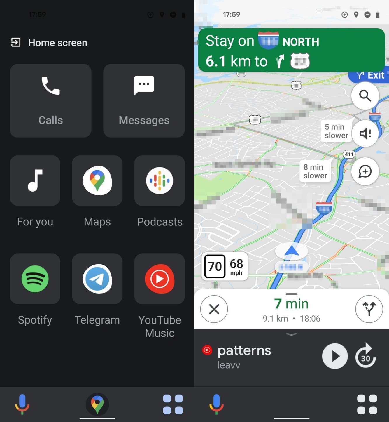
For phone-only users, there are a couple ways to keep using the app's features:
- Open Google Maps and then start Navigation. The phone will automatically show an overlay at the bottom of the screen with a home button, the mic button for voice control, and an "app drawer" button wich will show apps compatible with phone navigation (in my case Spotify or YT Music). This overlay acts and loos better than the current AA for phone implementation
​
- Install Headunit Reloaded Emulator and use "self mode", wich starts full blown Android Auto on the phone's screen. You can change settings to adjust video quality, layout and compatibility, even autostart.
No, it's been over a year since new roads have been built in my city, still no update in google maps.
But Here maps (former Nokia maps) are updated within weeks.
https://play.google.com/store/apps/details?id=com.here.app.maps
They're both free, I'd just install and download maps for both, just in case one craps out.
I'm a huge fan of Transit for Android. It shows me all the bus lines near my location and you can click on line then on the location icon to see where the bus actually is (typically with a delay of just under a minute).
I'm in the UK and I use Velociraptor to get speed limit display on Google Maps. You can set it so it only appears when navigating.
https://play.google.com/store/apps/details?id=com.pluscubed.velociraptor
I was driving I-5 between Eugene and Portland one wintery day a few years ago and was driving with the Waze app running like I usually do. All of a sudden it had me take some random exit that I almost passed because I wasn't prepared to get off the freeway at all. Anyway I did it more out of curiosity than really wanting to save time or anything. The road it routed me to was 35 mph and I thought, "this is stupid!". The road paralleled I-5 in a couple spots and I came around a corner (as I was looking for another on-ramp getting ready to turn Waze off) and saw this huge back-up in both directions of I-5. Two tractor trailers and what looked like 10 cars/suv's were scattered across both the northbound and southbound lanes. Both directions closed for miles, except for the little road I was on. Waze had me drive about two miles farther up and I jumped on the freeway with zero traffic except for two cars that were behind me that I assume were also using Waze. Amazing.
On Android, velociraptor works pretty well. Open street map data source isn't very good near me, but I'm trying to submit improvements and using one of the paid sources in the meanwhile.
Or they could just drop their reskin of Transit App and encourage people to use the full version. That would save the devs time, and it allows Calgarians to get full functionality on the "new" official app.
Transit is worth checking out, too.
Not as good as Google Maps for planning a trip, but great for knowing which buses are departing nearby, and when, at a glance.
Open source : Maps (for of open Street maps)
Not open source but best overall and kinda really reliable :Here we go maps
Use the Transit App. My commute point is at a spot where the north route turns into the south route, and the predicted times are absolutely trash. The app shows where the actual bus is (assuming it has GPS built in, which nearly all of them do now). No more calgary transit russian roulette, I can now watch the bus, and head outside when the bus passes building X.
You can download the COTA schedule or use the Transit app, its supposed to give you live bus tracking and I've found it to be pretty accurate. Bus times can be a real crapshoot in general though.
https://play.google.com/store/apps/details?id=com.thetransitapp.droid&hl=en
Osmand works completely offline using only gps. you put in a destination and it gives you direction.
I made those widgets in KWGT (used to use Zooper Widgets) by importing full size image files.
The trick to high resolution icon is to go to Google Play on web browser, Waze for example, drag the icon into new tab/address bar, and delete "=w300-rw" at the end of URL and hit enter, BAM! super large icon!
Tema colectivos: te recomiendo Moovit, te dice paradas, líneas, horarios, podés buscar de una dirección a otra y te tira varias opciones, te dice que líneas frenan por parada y está actualizada (Hasta donde sé, Google Maps te puede fallar si hubo alguna modificación de línea o de ruta).
Here WeGo is pretty good. I use it when I'm abroad and going to places were signal is lacking.
The biggest downside is that the maps are very large - partly because they are so detailed.
https://play.google.com/store/apps/details?id=com.here.app.maps
"Öffi" for Android supports these regional network plans: • Berlin & Brandenburg (BVG, VBB) • Frankfurt & Rhein-Main (RMV) • München (MVV, MVG) • Augsburg (AVV) • Schwerin & Mecklenburg-Vorpommern (VMV) • Rostock (RSAG) • Kiel, Lübeck & Schleswig-Holstein (nah.sh) • Hannover & Niedersachsen (GVH) • Göttingen & Südniedersachsen (VSN) • Braunschweig (BSVAG) • Bremen (BSAG) • Bremerhaven & Oldenburg (VBN) • Leipzig & Sachsen-Anhalt (NASA) • Dresden (DVB, VVO) • Chemnitz & Mittelsachsen (VMS) • Essen, Dortmund, Düsseldorf & Rhein-Ruhr (VRR) • Köln, Bonn (KVB, VRS) • Lüdenscheid & Märkischer Kreis (MVG) • Paderborn & Höxter (nph) • Mannheim & Rhein-Neckar (VRN) • Stuttgart (VVS) • Reutlingen & Neckar-Alb-Donau (NALDO) • Ulm (DING) • Karlsruhe (KVV) • Trier (VRT) • Nürnberg, Fürth & Erlangen (VGN) • Würzburg & Regensburg (VVM) • Straßburg & Freiburg • Baden-Württemberg (NVBW) • Plauen & Vogtland (VVV) • Wien, Niederösterreich & Burgenland • Oberösterreich (OÖVV) • Linz (Linz AG) • Salzburg • Innsbruck (IVB) • Graz & Steiermark (STV) • Bregenz & Vorarlberg • Basel (BVB) • Luzern (VBL) • Zürich (ZVV) • Brüssel (STIB, MIVB) • Amsterdam • Kopenhagen (Metro) • Stockholm (SL) • London (TfL) • Birmingham • Liverpool • Dublin • Warschau (ZTM)
and more.
https://play.google.com/store/apps/details?id=com.thetransitapp.droid&hl=en
https://itunes.apple.com/us/app/transit-real-time-app-for/id498151501?mt=8
This uses people's location when they are using the route feature to catch a specific bus, and updates live bus locations by using people's geo-location. It was accurate for me even through the rainstorm on Wednesday night with all the delays.
The cell data screen on the Republic App will allow you granular control over which apps can access cellular data. On the 'CELL DATA' screen, just tap on the white bar at the bottom (where it displays 'Call Data Used') and you can toggle cellular data access for messenger, etc there.
Have you tried HERE Maps? https://play.google.com/store/apps/details?id=com.here.app.maps&hl=en
It's a great GPS app that allows you to preload map data onto your phone, allowing you to use your phone's GPS without using data. It's a great app.
I personally find Here Maps to be better. The interface is much more intuitive.
And the quality of the maps seem to be at least equal, if not better, to Open Street Maps (although that may vary by region).
Nokia Here is great. It even knows the current speed limit and beeps when you go over (but in a helpful, not annoying way). Unfortunately, I'm invested in the Google ecosystem for my search history, starred places, contacts, etc., and the Here search is nowhere near as reliable as Google's.
AFAIK Google Maps will only store offline maps for 30 days, because of something about licensing.
Instead: Nokia HERE is the best offline GPS map app I've used.
You can also use OSMAnd for mapping on Android. Download your map(s) and use offline. No data/wireless needed once all setup, and it uses your device's GPS/location. https://f-droid.org/app/net.osmand.plus or https://play.google.com/store/apps/details?id=net.osmand for download.
I'd recommend either downloading offline maps in Google Maps and/or installing a dedicated offline navigation app, ideally one based on OpenStreetMap (basically the maps equivalent of Wikipedia), which are very accurate, more accurate than Google Maps or its competitors in my experience. OsmAnd works very well. I've used it for a job that required me to go door to door in areas with little to no Internet coverage. Since OpenStreetMap data usually includes far more exact street layouts and addresses, it's ideal for this purpose.
> Grab a map of the subway and keep it handy.
Personally though I can really recommend the "Citymapper" app for your phone for this.
This app features digital versions of the subway map, available to view offline.
But it also gives the option to plan and set a journey and save it offline, so you can even easily access it while underground.
Sounds like an advertisement (And I think in some way I'm just doing that xD) But this app has already helped be a great deal when I was in Tokyo, London and Amsterdam. Really useful if you're planning on travelling with public transport.
Now any 'verbal' advertisement wouldn't be complete if I didn't add a Apple and Android url.
Mag ik je aanraden om Waze eens te proberen? Dit is een app gebaseerd op de wegdata van Maps, met ingebouwde functionaliteiten voor melden van flitsers en vertragingen e.d.
Headunit Reloaded does a decent job of it, somewhat laggy but gets it from your phone on to any other Android unit via WiFi. I tested it on my new headunit for my Mustang and it was surprisingly okay, but I prefer the native version of apps on it instead.
Als App: Kann nur HERE WeGo wärmstens empfehlen (war früher mal die Nokia-Navi App, soweit ich informiert bin). Gratis offline Karten für ganz Europa (und eventuell weltweit, hab mich nicht weiter dafür interessiert), von der Bedienung her imho sehr angenehm und hat mich bereits problemlos durch Österreich und Slowenien navigiert. Die überwiegend positiven Kommentare bei einer gratis Navi-App sollten auch recht eindeutig sein.
The HERE app from Nokia lets you download State, province, or country maps.
It doesn't intuitively find places unless you are online but you can create 'collections' of locations that will be saved for offline access, or lookup addresses offline. good if you know where you will be and want to save some spots ahead of time, or as a backup in case you can't access google maps.
Install Headunit Reloaded onto the tablet - https://play.google.com/store/apps/details?id=gb.xxy.hr&hl=en_US&gl=US
Yes, this! Also, for anyone with an Android phone, I highly recommend OsmAnd - https://play.google.com/store/apps/details?id=net.osmand&hl=en_US - it's not great for real-time navigation (although it can do it), but it's phenomenal because you can download offline maps for entire states, and they never expire.
It's also great if one is into hiking, as it has way more trails than google maps. I realize that's tangential to the OP's needs, but just an FYI, as I love camping, hiking and backpacking, and it's one of my essential tools (I pay for the paid version that has unlimited downloads and topo maps). There are other apps better focused on hiking/backpacking, and better apps focused on real-time navigation, but for the "I want offline maps for an entire country/state," I really love OsmAnd.
Found the Play Store app but there are no links to source code.
From their website:
> # Advertising Data Services >Smart location context that takes advertising campaigns to the next level. Yield more profits with your ad spend by reaching the right audience using a REST API that enriches user location data with smart location context for more precise audience segmentation and attribution.
So now I want to ask:
Are you sure about that?
I usually use the "scotty" app.
Edit: https://play.google.com/store/apps/details?id=de.schildbach.oeffi also works fine, but is not live afaik and doesn't really do routing. More of a timetable helper.
Bon matin! (je dis ça juste pour t'agacer! ��)
Open Street Map sur android permet de télécharger une province au complet (plus qu'une même). C'est ben pratique en tout temps, pour éviter de télécharger des données en LTE/4G. C'est une ressource que j'utilise depuis plusieurs années, autant en Amérique qu'en Europe. Icitte
You can see the data that Google collects from your account. My Activity will show you all the stuff Google collects and you can delete it. My Timeline will also show you where Google has you "checking in" with Maps. The timeline data can be deleted and can be disabled. FYI, Google offers offline maps and wifi only mode (which uses a tiny amount data despite being WiFi only).
Otherwise, I think Here is probably a good option for you. I used ti awhile ago but went back to Maps simply to have my Google apps more integrated with each other.
Edit: I think you should also just understand that navigation apps are going to need a fair bit of access to know where you are, manage maps, and give you directions.
If you have an Android phone check out the Öffi app . It pretty much works with all public transport in Germany and has many useful features :)
My favorite app is Öffi. You can search from point to point and the visual representation of the possible routes is the best of all apps I know.
Use the Waze app. Users will report when they see speed traps and you'll have warning. It's available for android or ios and it is free. Works great.
Waze in the Google play store link, Waze for IOS link, I think
Citymapper was invaluable to me during a recent trip to London.
They cover a limited number of cities, so be sure to check the list.
The best one I've found is Offi - Journey Planner. The Directions feature lets you put in start/end locations and times, and will tell you whatever combo of public transport you'll use for the whole trip -train, tram, bus etc. It's not a beautiful app but it's the most fully featured I've found.
If you want something just for trains, Melbourne Train Trapper is a pretty simple app that can do similar journey planning on the train network.
I recently traveled in Europe using HERE Maps and had no issues at all. Highly recommended, although I can vouch for European offline maps only.
A little context for people that don't know. Waze is a free app that uses data collected from users to provide real time traffic information which gets layered on to a conventional GPS/nav app. It's free. Google bought them for something like a billion.
What is great about Waze is the real time traffic data let you avoid brutal rush hour accidents like this one so you can pick a different place to get on the freeway or choose a new route altogether. It even let's you know where red light cameras are and people often use it to report speed traps and things like minor collisions and construction. This app has saved me many hours in traffic.
https://play.google.com/store/apps/details?id=com.waze&hl=en
On the S10 I just have AA installed and updated.
On the Atoto I have HeadUnit Reloaded installed. First I downloaded the trial version to make sure it worked. Once confirmed I bought the paid app. https://play.google.com/store/apps/details?id=gb.xxy.hr&hl=en_US
Install HeadUnit Reloaded onto your Head Unit, plug in the phone and it should prompt a set up. I think you might need USB debugging on both the phone and headunit enabled.
If you have other questions, I can try to answer them.
The app simply called Transit also has that same live HSR feed. WIth the app's latest update, the feature called "Go" can dynamically on-the-fly tell you the best busses to catch to get to your destination the quickest based on this live data. Not trying to throw out a promotion for the heck of it, but it has helped me on the ocasional times I had to take the HSR.
I use the Transit app on my android phone. Looks like there's an iPhone version as well: https://itunes.apple.com/us/app/transit-real-time-app-for-bus-subway-metro/id498151501?mt=8
Edit: The android version, by request: https://play.google.com/store/apps/details?id=com.thetransitapp.droid
No recommendation for phones, but HERE WeGo's offline maps are great. Travelled around a bit with offline maps and they never fail me. In fact, Google Maps now support offline maps.
I have an app called "Transit" on Android. It works beautifully for ETS (plus St. Albert and Strathcona County transit if you use those.)
Or, you can just use Waze. They're everywhere this week. Google Play | iFruits
Transit App has worked beautifully for me. It also includes a ton of other bus and public transportation lines, but if you're looking specifically just for BART, there is an option to turn specific bus systems on or off in the settings, so you can make BART the only visible service.
I've used Osmand+ for over 3 years. It just keeps getting better. There is a free version that limits access to only 10 tilesets. The learning curve is a bit much for the casual user, but enthusiasts will have no problem figuring it out.
A couple of the config options are a little screwy, such as pointing to external SD card for maps downloaded from another source. The UX is decidedly NOT Material.
We were in Europe for 3 weeks with Osmand maps I downloaded before we left. Even though I had data and could use Google Maps, my wife preferred navigating with Osmand. Especially in Netherlands, Belgium and France, because the road data is very precise. Knowing which lanes to be in for turns a kilometer in advance saved my butt more than once.
Edit: add link to free
Transit has live GPS feeds of about half the Metro Transit bus fleet. It's not the shitty mess that NexTrip is. There absolutely are dependable options for planning public transit if you spend a little time looking.
T-Mobile kinda sucks for domestic roaming. There no native coverage in West Virginia except for the panhandle. I have no business in West Virginia except having to pass through it while driving to Pittsburgh from the south. There's roaming on ATT, but 50MB is useless in the age of smartphones. For any roadtrip of decent length, I recommend downloading Here Maps and the individual maps for any states you're going through.
The waze app has a feature to make it nice and easy to report these potholes. It also makes it simple to point out shakedown points to fellow travellers.
Only you can help prevent highway robbery!!
Use Waze because 80-90% of cops running radar are on there.
Save music and podcasts locally to your phone for rural areas in case you lose service. Similarly, use offline maps in Google Maps so you can navigate and reroute without service.
Keep nicotine gum in your car so that if you get too tired and start falling asleep at the wheel, you can use it to wake up long enough to find somewhere safe to pull over and rest. It will wake you up in about thirty seconds and wears off quickly once you stop chewing it so you can fall asleep. Even if you would never smoke or vape, consider this...the gum is not really harmful and it could save your life.
Get a lock box and pack it somewhere you can't reach it while driving. It is considered a separate search space in traffic stops and, should your car get searched, they can't open it without a warrant. If it is a combo lock or password (something you know), the Fifth Amendment protects you from having to open it under any circumstances.
(obligatory "I am not a lawyer" and "do your own research")
Drive safe and see you there!
Apparently they renamed it from Here Maps to Here WeGo.
Android: https://play.google.com/store/apps/details?id=com.here.app.maps&hl=en_CA
iOS: https://itunes.apple.com/us/app/here-wego-city-navigation/id955837609?mt=8
Try searching for the area around which your trying to save like the country and click download button when the place pops up click here. Also if you want offline for the best app is HERE WeGo it is good for offline use, I recommend having both google maps for online and HERE for offline.
~~Don't spread false information. GPS Joystick works perfectly fine.~~ https://play.google.com/store/apps/details?id=com.theappninjas.gpsjoystick&hl=en_US
Edit: I am an idiot. Both are the same app. Ignore me.
https://play.google.com/store/apps/details?id=com.theappninjas.gpsjoystick&hl=en
This. You need to enable the privacy mode, that will generate a new installation with random name. But that's only the first part. The following steps will require root permission, so if you are not comfortable with that I would advise against it.
You will need to locate the installed APK with new random name using a root explorer, I use ES file explorer. The location can be different for different devices, mine is under /data/app. Move the apk into a new folder under /system/priv-app. Uninstall both the Ninja GPS installed earlier. and reboot the device. You should see that the gps spoofer is back as system app (non-removable). Now if u run the spoofer, the system will not ask for mock location permission.
Hope it helps.
Edit: I forgot to mention, you will need systemless root. The only one i know is Magisk. Download it from xda and use your Magisk to hide root from play store. You cts profile should be green or else you won't be able to log into pogo.
Transit has realtime BART schedules as well as most of the major transit agencies in the area (Caltrain, Muni, AC Transit, etc.)
This app is what I used for a while. Takes a little bit to get used to but otherwise not too bad of an app. It works with gpx files but not all gpx files will be displayed in a correct manner so that it can be used for navigation though.
If you have an android phone, you can use the free app "HERE WeGo". Inside the app, go to Download maps. (The map for Georgia is located under "Europe".) Their maps are also free and although I can't vouch for all of the Georgia map, I have examined the small village roads in my village and the map is accurate as far as asphalt roads go. Dust roads are not visible. The problem though is that there are almost no place names, so you have to locate your destinations by Google Maps and plot them into the navigator. If this is an acceptable solution, you don't need internet connection at all during your trip. I agree with TBOIOMATb_CYKA that reception is mostly exceptional, but the problem is that in some parts of Georgia there is no connection at all. You shouldn't rely on having a connection. You can also buy paper maps. There used to be a map shop right next to the Dry Bridge in Tbilisi which had all kinds of maps and a big printer to make tailor made maps for your needs.
Falls du die von der Bahn nicht magst gibt es noch Öffi: https://play.google.com/store/apps/details?id=de.schildbach.oeffi&hl=de
Hatte ich jetzt schon in einigen Städten benutzt. Hat ein netteres UI, ist kleiner und braucht nicht so viele Rechte wie die der Bahn. Aus irgendwelchen Gründen hat die in Frankfurt manchmal schneller die S-Bahn Verspätungen als die Bahn App.
Or use this.
- Velociraptor - Map Speed Limit – Android Apps on Google Play - https://play.google.com/store/apps/details?id=com.pluscubed.velociraptor
IAP is for support for open street maps.
Is PDX Bus still iPhone only?
If so, Transit is the best app I've used. It looks great, it works well and is easy to use.
They have an iOS version as well if you're a UI snob. I've always thought PDX Bus looked like garbage.
There's no first hand map app but one like this https://play.google.com/store/apps/details?id=net.osmand&hl=en uses OSM data.
The main native site https://www.openstreetmap.org/ works really well from a mobile browser. So just hitting this on your phone will work.